Ro Ellen, Tennessee
Submit your own pictures of this place and show them to the world
- OSM Map
- General Map
- Google Map
- MSN Map

| Males: 1,055 | |
| Females: 1,051 |
| Median resident age: | 38.3 years |
| Tennessee median age: | 35.9 years |
Zip code: 38024
| Ro Ellen: | $73,096 |
| TN: | $65,254 |
Estimated per capita income in 2022: $36,131 (it was $15,599 in 2000)
Ro Ellen CCD income, earnings, and wages data
Estimated median house or condo value in 2022: $180,940 (it was $71,600 in 2000)
| Ro Ellen: | $180,940 |
| TN: | $284,800 |
Mean prices in 2022: all housing units: $223,070; detached houses: $223,339; townhouses or other attached units: $343,600; in 3-to-4-unit structures: $514,806; mobile homes: $142,455
Detailed information about poverty and poor residents in Ro Ellen, TN


- 2,00596.1%White alone
- 602.9%Black alone
- 140.7%Hispanic
- 40.2%Two or more races
- 30.1%American Indian alone

Races in Ro Ellen detailed stats: ancestries, foreign born residents, place of birth
 Recent articles from our blog. Our writers, many of them Ph.D. graduates or candidates, create easy-to-read articles on a wide variety of topics.
Current Local Time: CST time zone
Land area: 40.9 square miles.
Population density: 51 people per square mile (very low).

| Ro Ellen CCD: | 0.5% ($372) |
| Tennessee: | 0.8% ($715) |
Nearest city with pop. 50,000+: Jackson, TN  (36.9 miles , pop. 59,643).
Nearest city with pop. 200,000+: Memphis, TN (74.1 miles , pop. 650,100).
Nearest city with pop. 1,000,000+: Chicago, IL (411.3 miles , pop. 2,896,016).
Nearest cities:
), ), ), )Latitude: 36.02 N, Longitude: 89.27 W
Area code commonly used in this area: 731


| Here: | 3.5% |
| Tennessee: | 3.0% |

- Construction (8.7%)
- Printing & related support activities (7.2%)
- Electrical equipment, appliances, components (5.9%)
- Educational services (5.8%)
- Plastics & rubber products (5.4%)
- Religious, grantmaking, civic, professional, similar organizations (5.3%)
- Textile mills & textile products (5.2%)

- Construction (14.4%)
- Printing & related support activities (10.5%)
- Plastics & rubber products (8.6%)
- Textile mills & textile products (6.7%)
- Department & other general merchandise stores (4.2%)
- Religious, grantmaking, civic, professional, similar organizations (4.2%)
- Electrical equipment, appliances, components (4.2%)

- Educational services (9.2%)
- Health care (8.3%)
- Electrical equipment, appliances, components (8.0%)
- Food & beverage stores (8.0%)
- Religious, grantmaking, civic, professional, similar organizations (6.6%)
- Finance & insurance (5.4%)
- Social assistance (4.7%)

- Other production occupations, including supervisors (9.2%)
- Laborers and material movers, hand (6.0%)
- Material recording, scheduling, dispatching, and distributing workers (5.0%)
- Cashiers (4.9%)
- Electrical equipment mechanics and other installation, maintenance, and repair workers, including supervisors (4.9%)
- Other sales and related occupations, including supervisors (3.7%)
- Building and grounds cleaning and maintenance occupations (3.6%)

- Other production occupations, including supervisors (12.8%)
- Electrical equipment mechanics and other installation, maintenance, and repair workers, including supervisors (8.8%)
- Building and grounds cleaning and maintenance occupations (5.7%)
- Laborers and material movers, hand (5.2%)
- Construction traders workers except carpenters, electricians, painters, plumbers, and construction laborers (4.6%)
- Other sales and related occupations, including supervisors (3.8%)
- Supervisors, transportation, and material moving workers (3.8%)

- Cashiers (9.2%)
- Material recording, scheduling, dispatching, and distributing workers (7.3%)
- Laborers and material movers, hand (7.1%)
- Assemblers and fabricators (6.1%)
- Retail sales workers, except cashiers (5.7%)
- Other office and administrative support workers, including supervisors (5.2%)
- Information and record clerks, except customer service representatives (4.7%)
Average climate in Ro Ellen, Tennessee
Based on data reported by over 4,000 weather stations


(lower is better)

Air Quality Index (AQI) level in 2022 was 61.7. This is about average.
| City: | 61.7 |
| U.S.: | 72.6 |

Nitrogen Dioxide (NO2) [ppb] level in 2003 was 3.30. This is significantly better than average. Closest monitor was 20.1 miles away from the city center.
| City: | 3.30 |
| U.S.: | 5.11 |

Sulfur Dioxide (SO2) [ppb] level in 2003 was 1.35. This is about average. Closest monitor was 20.1 miles away from the city center.
| City: | 1.35 |
| U.S.: | 1.51 |

Ozone [ppb] level in 2003 was 34.2. This is about average. Closest monitor was 6.7 miles away from the city center.
| City: | 34.2 |
| U.S.: | 33.3 |

Particulate Matter (PM2.5) [µg/m3] level in 2022 was 7.65. This is about average. Closest monitor was 6.7 miles away from the city center.
| City: | 7.65 |
| U.S.: | 8.11 |
Tornado activity:
Ro Ellen-area historical tornado activity is above Tennessee state average. It is 106% greater than the overall U.S. average.
On 3/21/1952, a category F4 (max. wind speeds 207-260 mph) tornado 3.8 miles away from the Ro Ellen place center killed 2 people and injured 10 people and caused between $50,000 and $500,000 in damages.
On 3/21/1952, a category F4 tornado 5.3 miles away from the place center killed 4 people and injured 5 people and caused between $50,000 and $500,000 in damages.
Earthquake activity:
Ro Ellen-area historical earthquake activity is significantly above Tennessee state average. It is 380% greater than the overall U.S. average.On 5/4/1991 at 01:18:54, a magnitude 5.0 (4.4 MB, 4.6 LG, 5.0 LG, Depth: 3.1 mi, Class: Moderate, Intensity: VI - VII) earthquake occurred 48.5 miles away from the city center
On 3/25/1976 at 00:41:20, a magnitude 5.0 (4.9 MB, 5.0 LG) earthquake occurred 65.1 miles away from Ro Ellen center
On 9/26/1990 at 13:18:51, a magnitude 5.0 (4.7 MB, 4.8 LG, 5.0 LG, Depth: 7.7 mi) earthquake occurred 80.4 miles away from Ro Ellen center
On 4/27/1989 at 16:47:49, a magnitude 4.7 (4.6 MB, 4.7 LG, 4.3 LG, Class: Light, Intensity: IV - V) earthquake occurred 28.0 miles away from the city center
On 4/18/2008 at 09:36:59, a magnitude 5.4 (5.1 MB, 4.8 MS, 5.4 MW, 5.2 MW) earthquake occurred 184.4 miles away from Ro Ellen center
On 4/18/2008 at 09:36:59, a magnitude 5.2 (5.2 MW, Depth: 8.9 mi) earthquake occurred 184.3 miles away from the city center
Magnitude types: regional Lg-wave magnitude (LG), body-wave magnitude (MB), surface-wave magnitude (MS), moment magnitude (MW)
Natural disasters:
The number of natural disasters in Dyer County (17) is near the US average (15).Major Disasters (Presidential) Declared: 13
Emergencies Declared: 2
Causes of natural disasters: Floods: 13, Storms: 12, Tornadoes: 6, Winds: 3, Winter Storms: 2, Flash Flood: 1, Hurricane: 1, Ice Storm: 1, Landslide: 1, Mudslide: 1, Other: 1 (Note: some incidents may be assigned to more than one category).
Hospitals and medical centers near Ro Ellen:
- OAKWOOD COMMUNITY LIVING CENTER (Nursing Home, about 7 miles away; DYERSBURG, TN)
- METHODIST HEALTHCARE ALLIANCE HLTH SRV (Hospital, about 7 miles away; DYERSBURG, TN)
- DYERSBURG REGIONAL MEDICAL CENTER Acute Care Hospitals (about 7 miles away; DYERSBURG, TN)
- HIGHLANDS OF DYERSBURG HEALTH AND REHAB (Nursing Home, about 7 miles away; DYERSBURG, TN)
- DYERSBURG DIALYSIS (Dialysis Facility, about 7 miles away; DYERSBURG, TN)
- DYERSBURG MANOR NURSING HOME (Nursing Home, about 7 miles away; DYERSBURG, TN)
- PROFESSIONAL HOME HEALTH AND HOSPIC SVCE (Home Health Center, about 7 miles away; DYERSBURG, TN)
Colleges/universities with over 2000 students nearest to Ro Ellen:
- Dyersburg State Community College (about 8 miles; Dyersburg, TN; Full-time enrollment: 2,211)
- The University of Tennessee-Martin (about 32 miles; Martin, TN; FT enrollment: 7,013)
- Union University (about 34 miles; Jackson, TN; FT enrollment: 4,051)
- Jackson State Community College (about 38 miles; Jackson, TN; FT enrollment: 2,958)
- Bethel University (about 43 miles; McKenzie, TN; FT enrollment: 5,878)
- Murray State University (about 67 miles; Murray, KY; FT enrollment: 8,930)
- Rhodes College (about 73 miles; Memphis, TN; FT enrollment: 2,052)
Points of interest:
Notable location: East Dyer County Volunteer Fire Department (A). Display/hide its location on the map
Churches in Ro Ellen include: Roellen Baptist Church (A), Rehoboth Church (B), Old Union Church (C), Union Grove Church (D), Mount Tirzah Church (E). Display/hide their locations on the map
Cemeteries: Viar Cemetery (1), Walker Cemetery (2), Shaw Cemetery (3), Reynolds Cemetery (4), RoEllen Cemetery (5), Pierce Cemetery (6), Rehoboth Cemetery (7). Display/hide their locations on the map
Lakes and reservoirs: Bishops Lake (A), Pillow Lake (B). Display/hide their locations on the map
Rivers and creeks: Lewis Creek (A), Hunsacker Creek (B), RoEllen Creek (C), Pond Creek (D), Middle Fork Forked Deer River (E). Display/hide their locations on the map
Park in Ro Ellen: Tigrett Wildlife Management Area (1). Display/hide its location on the map
| This place: | 2.6 people |
| Tennessee: | 2.5 people |
| This place: | 74.4% |
| Whole state: | 69.8% |
| This place: | 3.3% |
| Whole state: | 4.2% |
Likely homosexual households (counted as self-reported same-sex unmarried-partner households)
- Lesbian couples: 0.1% of all households
- Gay men: 0.3% of all households
| This place: | 16.0% |
| Whole state: | 13.5% |
| This place: | 8.3% |
| Whole state: | 5.8% |
For population 15 years and over in Ro Ellen:

- Never married: 18.0%
- Now married: 69.2%
- Separated: 1.2%
- Widowed: 5.1%
- Divorced: 7.7%
For population 25 years and over in Ro Ellen:
- High school or higher: 66.2%
- Bachelor's degree or higher: 4.5%
- Graduate or professional degree: 2.0%
- Unemployed: 4.6%
- Mean travel time to work (commute): 21.6 minutes


| Here: | 12.0 |
| Tennessee average: | 13.3 |
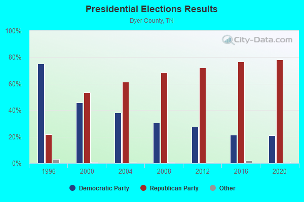
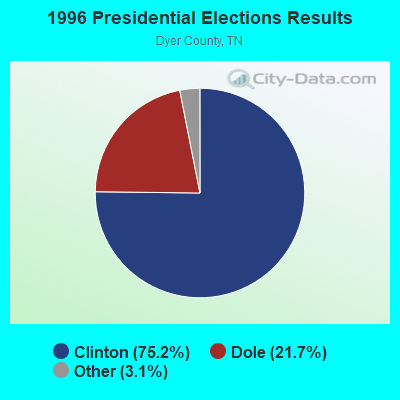
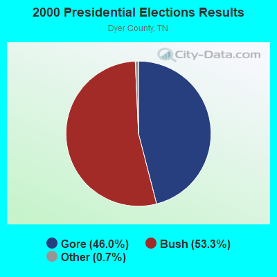
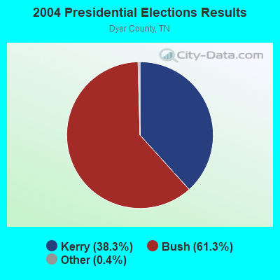
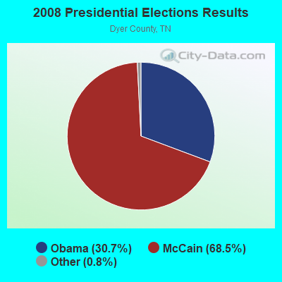
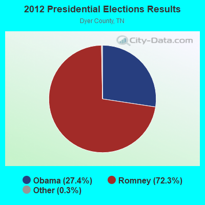
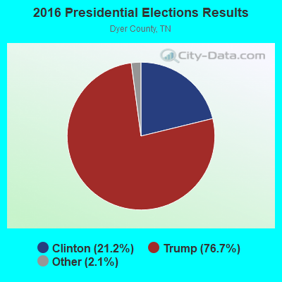
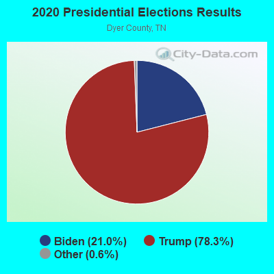
Graphs represent county-level data. Detailed 2008 Election Results
Religion statistics for Ro Ellen, TN (based on Dyer County data)
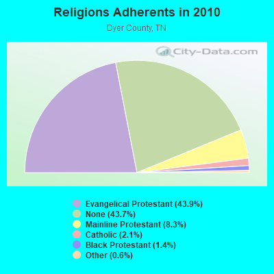
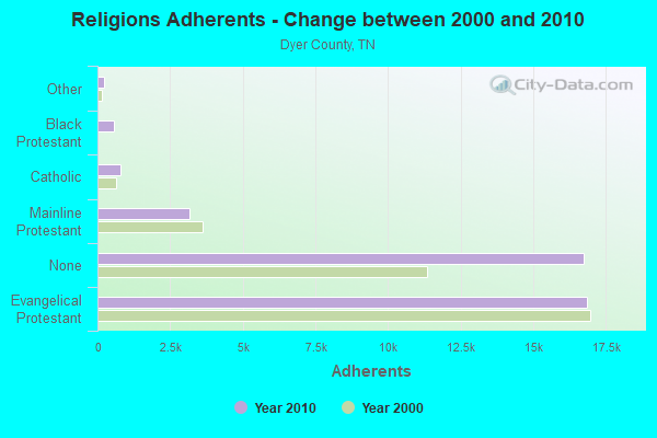
| Religion | Adherents | Congregations |
|---|---|---|
| Evangelical Protestant | 16,830 | 78 |
| Mainline Protestant | 3,176 | 16 |
| Catholic | 800 | 1 |
| Black Protestant | 555 | 7 |
| Other | 238 | 2 |
| None | 16,736 | - |
Food Environment Statistics:
| Dyer County: | 2.39 / 10,000 pop. |
| State: | 1.99 / 10,000 pop. |
| This county: | 0.27 / 10,000 pop. |
| State: | 0.17 / 10,000 pop. |
| This county: | 0.27 / 10,000 pop. |
| Tennessee: | 0.65 / 10,000 pop. |
| Dyer County: | 6.64 / 10,000 pop. |
| Tennessee: | 5.16 / 10,000 pop. |
| Dyer County: | 6.11 / 10,000 pop. |
| Tennessee: | 6.56 / 10,000 pop. |
| Dyer County: | 11.5% |
| Tennessee: | 11.4% |
| Dyer County: | 33.2% |
| Tennessee: | 30.2% |
| Dyer County: | 16.2% |
| Tennessee: | 13.5% |
Strongest AM radio stations in Ro Ellen:
- WTRO (1450 AM; 1 kW; DYERSBURG, TN; Owner: DR PEPPER PEPSI COLA BOTTLING CO.)
- WCRV (640 AM; 50 kW; COLLIERVILLE, TN; Owner: BOTT BROADCASTING COMPANY/TENNESSEE)
- WDIA (1070 AM; 50 kW; MEMPHIS, TN; Owner: CLEAR CHANNEL BROADCASTING LICENSES, INC.)
- WGSF (1030 AM; 50 kW; MEMPHIS, TN; Owner: FLINN BROADCASTING CORPORATION)
- WMQM (1600 AM; 50 kW; LAKELAND, TN; Owner: WMQM, INC.)
- KOTC (830 AM; daytime; 10 kW; KENNETT, MO; Owner: EAGLE BLUFF ENTERPRISES)
- KLCN (910 AM; 5 kW; BLYTHEVILLE, AR; Owner: SUDBURY SERVICES, INC.)
- WSM (650 AM; 50 kW; NASHVILLE, TN; Owner: GAYLORD ENTERTAINMENT COMPANY)
- WDXI (1310 AM; 5 kW; JACKSON, TN; Owner: LIBERTY RADIO II, INC.)
- WTJS (1390 AM; 5 kW; JACKSON, TN; Owner: CAPSTAR TX LIMITED PARTNERSHIP)
- WJCE (680 AM; 10 kW; MEMPHIS, TN; Owner: ENTERCOM MEMPHIS LICENSE, LLC)
- WCPC (940 AM; 50 kW; HOUSTON, MS; Owner: WCPC BROADCASTING CO., INC.)
- WKDA (1200 AM; 50 kW; NASHVILLE, TN; Owner: RADIO NASHVILLE, INC.)
Strongest FM radio stations in Ro Ellen:
- WASL (100.1 FM; DYERSBURG, TN; Owner: DR PEPPER PEPSI-COLA BOTTLING CO.)
- W205BN (88.9 FM; DYERSBURG, TN; Owner: WAY-FM MEDIA GROUP, INC.)
- WKNQ (90.7 FM; DYERSBURG, TN; Owner: MID-SOUTH PUBLIC COMMS. FOUNDATION)
- W202BG (88.3 FM; DYERSBURG, TN; Owner: BIBLE BROADCASTING NETWORK, INC.)
- WLSQ-FM (94.3 FM; DYER, TN; Owner: F. DARRELL BOYD)
- WYNU (92.3 FM; MILAN, TN; Owner: CAPSTAR TX LIMITED PARTNERSHIP)
- WWYN (106.9 FM; MCKENZIE, TN; Owner: RAINBOW MEDIA, INC.)
- WAPO (90.5 FM; MOUNT VERNON, IL; Owner: AMERICAN FAMILY ASSOCIATION)
- WAUV (89.7 FM; RIPLEY, TN; Owner: AMERICAN FAMILY ASSOCIATION)
- WKVZ (94.9 FM; RIPLEY, TN; Owner: EDUCATIONAL MEDIA FOUNDATION)
- WWGM (93.1 FM; ALAMO, TN; Owner: GRACE BROADCASTING SERVICES, INC.)
- WTNE-FM (97.7 FM; TRENTON, TN; Owner: GIBSON COUNTY BROADCASTING COMPANY, INC.)
- WTNV (104.1 FM; JACKSON, TN; Owner: CAPSTAR TX LIMITED PARTNERSHIP)
TV broadcast stations around Ro Ellen:
- WDYR-CA (Channel 33; DYERSBURG, TN; Owner: TRI-STATE CHRISTIAN TV, INC.)
- WJKT (Channel 16; JACKSON, TN; Owner: CLEAR CHANNEL BROADCASTING LICENSES, INC.)
- WBBJ-TV (Channel 7; JACKSON, TN; Owner: TENNESSEE BROADCASTING PARTNERS)
- WJTE-LP (Channel 19; JACKSON, TN; Owner: TIGER EYE BROADCASTING CORPORATION)
- W26CJ (Channel 26; JACKSON, TN; Owner: MS COMMUNICATIONS, LLC)
- W22BR (Channel 22; JACKSON, TN; Owner: MS COMMUNICATIONS, LLC)
- W52CZ (Channel 52; JACKSON, TN; Owner: MS COMMUNICATIONS, LLC)
- W64BZ (Channel 64; JACKSON, TN; Owner: MS COMMUNICATIONS, LLC)

- 55.0%Electricity
- 30.5%Utility gas
- 12.4%Bottled, tank, or LP gas
- 2.0%Wood

- 42.3%Utility gas
- 42.3%Electricity
- 15.5%Bottled, tank, or LP gas
Ro Ellen compared to Tennessee state average:
- Median house value below state average.
- Unemployed percentage significantly below state average.
- Black race population percentage significantly below state average.
- Hispanic race population percentage significantly below state average.
- Foreign-born population percentage significantly below state average.
- Renting percentage significantly below state average.
- Length of stay since moving in significantly above state average.
- Number of rooms per house significantly below state average.
- House age significantly below state average.
- Percentage of population with a bachelor's degree or higher significantly below state average.
State forum archive:
- Tennessee Pages: 2 3 4 5 6 7 8 9 10 11 12 13 14 15 16 17 18 19 20 21 22 23 24 25 26 27 28 29 30 31 32
- Chattanooga Pages: 2 3 4 5 6 7 8 9 10 11 12 13
- Cookeville Pages: 2 3 4 5 6 7 8 9 10 11
- Kingsport - Johnson City - Bristol Pages: 2 3 4 5 6 7 8 9 10 11 12 13 14 15 16 17 18 19
- Knoxville Pages: 2 3 4 5 6 7 8 9 10 11 12 13 14 15 16 17 18 19 20 21 22 23 24 25 26 27 28 29 30 31
- Memphis Pages: 2 3 4 5 6 7 8 9 10 11 12 13 14 15 16 17 18 19 20
- Nashville Pages: 2 3 4 5 6 7 8 9 10 11 12 13 14 15 16 17 18 19 20 21 22 23 24 25 26 27 28 29 30 31 32 33 34 35 36 37 38 39 40 41 42 43 44 45 46 47 48 49 50 51 52 53 54 55 56 57