Reservation, Oregon
Submit your own pictures of this place and show them to the world
- OSM Map
- General Map
- Google Map
- MSN Map

| Males: 1,458 | |
| Females: 1,558 |
| Median resident age: | 35.2 years |
| Oregon median age: | 36.3 years |
| Reservation: | $80,358 |
| OR: | $75,657 |
Estimated per capita income in 2022: $29,917 (it was $15,158 in 2000)
Reservation CCD income, earnings, and wages data
Estimated median house or condo value in 2022: $339,548 (it was $108,600 in 2000)
| Reservation: | $339,548 |
| OR: | $475,600 |
Detailed information about poverty and poor residents in Reservation, OR
Compare current foreclosures near Reservation, OR:
| Photo | Address | Area | Beds / Baths | Price | Details |
|---|---|---|---|---|---|

|
#1
SW 4th St
Pendleton, OR 97801
|
1,340 sq. feet
|
1 baths 3 beds |
show details | |

|
#2
SW 24th St
Pendleton, OR 97801
|
1,414 sq. feet
|
1 baths 3 beds |
show details | |

|
#3
SW 8th St
Pendleton, OR 97801
|
1,360 sq. feet
|
2 baths 3 beds |
show details | |

|
#4
Poverty Flat Rd
Pendleton, OR 97801
|
801 sq. feet
|
1 baths 3 beds |
show details | |

|
#5
SW Hailey Ave
Pendleton, OR 97801
|
1,399 sq. feet
|
1 baths 2 beds |
show details | |

|
#6
NE Nelson Dr
Pendleton, OR 97801
|
1,784 sq. feet
|
2 baths 3 beds |
show details | |

|
#7
SW 30th St
Pendleton, OR 97801
|
1,059 sq. feet
|
1 baths 2 beds |
show details | |

|
#8
SW Court Ave
Pendleton, OR 97801
|
1,416 sq. feet
|
2 baths 3 beds |
show details | |

|
#9
NW 11th St
Pendleton, OR 97801
|
- sq. feet
|
- baths - beds |
show details | |

|
#10
SW 12th Dr
Pendleton, OR 97801
|
- sq. feet
|
- baths - beds |
show details |
| Photo | Address | Area | Beds / Baths | Price | Details |
|---|---|---|---|---|---|

|
#11
NW 3rd Dr Apt B
Pendleton, OR 97801
|
- sq. feet
|
- baths - beds |
show details | |

|
#12
SW Court Ave Apt 107
Pendleton, OR 97801
|
- sq. feet
|
- baths - beds |
show details | |

|
#13
NE Riverside Ave
Pendleton, OR 97801
|
- sq. feet
|
- baths - beds |
show details | |

|
#14
SW 3rd St # B
Pendleton, OR 97801
|
- sq. feet
|
- baths - beds |
show details | |

|
#15
SW Nye Ave
Pendleton, OR 97801
|
- sq. feet
|
- baths - beds |
show details | |

|
#16
SW Nye Ave
Pendleton, OR 97801
|
- sq. feet
|
- baths - beds |
show details | |

|
#17
SE Byers Ave Apt 1
Pendleton, OR 97801
|
- sq. feet
|
- baths - beds |
show details | |

|
#18
SE 7th St
Pendleton, OR 97801
|
- sq. feet
|
- baths - beds |
show details | |

|
#19
SE Isaac Ave Apt 4
Pendleton, OR 97801
|
- sq. feet
|
- baths - beds |
show details | |

|
#20
SE 10th St
Pendleton, OR 97801
|
- sq. feet
|
- baths - beds |
show details |
| Photo | Address | Area | Beds / Baths | Price | Details |
|---|---|---|---|---|---|

|
#21
Oak Ln
Meacham, OR 97859
|
- sq. feet
|
- baths - beds |
show details | |

|
#22
SE Court Ave # 1
Pendleton, OR 97801
|
- sq. feet
|
- baths - beds |
show details | |

|
Check over 1 million property listings on Foreclosure.com!
|
browse all offers | |||

- 1,40047.8%American Indian alone
- 1,36446.6%White alone
- 802.7%Two or more races
- 622.1%Hispanic
- 100.3%Asian alone
- 60.2%Other race alone
- 40.1%Black alone
- 10.03%Native Hawaiian and Other
Pacific Islander alone

Races in Reservation detailed stats: ancestries, foreign born residents, place of birth
 Recent articles from our blog. Our writers, many of them Ph.D. graduates or candidates, create easy-to-read articles on a wide variety of topics.
Current Local Time: PST time zone
Land area: 249.4 square miles.
Population density: 12 people per square mile (very low).

| Reservation CCD: | 1.0% ($1,043) |
| Oregon: | 1.2% ($1,687) |
Nearest city with pop. 50,000+: Kennewick, WA  (46.5 miles , pop. 54,693).
Nearest city with pop. 200,000+: Northwest Clackamas, OR (197.4 miles , pop. 224,220).
Nearest city with pop. 1,000,000+: Los Angeles, CA (801.6 miles , pop. 3,694,820).
Nearest cities:
), ), ), Latitude: 45.67 N, Longitude: 118.56 W
Area code commonly used in this area: 541


| Here: | 4.1% |
| Oregon: | 3.9% |

- Public administration (19.7%)
- Arts, entertainment, recreation (13.0%)
- Health care (8.8%)
- Educational services (7.2%)
- Construction (7.2%)
- Agriculture, forestry, fishing & hunting (5.8%)
- Accommodation & food services (5.0%)

- Public administration (20.9%)
- Arts, entertainment, recreation (13.3%)
- Construction (12.2%)
- Agriculture, forestry, fishing & hunting (8.7%)
- Health care (4.6%)
- Educational services (3.7%)
- Food (2.8%)

- Public administration (18.3%)
- Health care (13.3%)
- Arts, entertainment, recreation (12.7%)
- Educational services (11.0%)
- Accommodation & food services (7.3%)
- Social assistance (6.5%)
- Agriculture, forestry, fishing & hunting (2.6%)

- Supervisors and other personal care and service workers, except child care workers (5.6%)
- Building and grounds cleaning and maintenance occupations (4.8%)
- Other management occupations, except farmers and farm managers (4.7%)
- Secretaries and administrative assistants (3.7%)
- Other office and administrative support workers, including supervisors (3.4%)
- Law enforcement workers, including supervisors (3.0%)
- Counselors, social workers, and other community and social service specialists (2.9%)

- Building and grounds cleaning and maintenance occupations (7.3%)
- Electrical equipment mechanics and other installation, maintenance, and repair workers, including supervisors (5.1%)
- Law enforcement workers, including supervisors (4.9%)
- Supervisors and other personal care and service workers, except child care workers (4.3%)
- Other management occupations, except farmers and farm managers (3.9%)
- Laborers and material movers, hand (3.6%)
- Construction laborers (3.4%)

- Supervisors and other personal care and service workers, except child care workers (7.0%)
- Secretaries and administrative assistants (7.0%)
- Other management occupations, except farmers and farm managers (5.7%)
- Other office and administrative support workers, including supervisors (5.0%)
- Information and record clerks, except customer service representatives (5.0%)
- Preschool, kindergarten, elementary, and middle school teachers (4.5%)
- Cashiers (4.4%)
Average climate in Reservation, Oregon
Based on data reported by over 4,000 weather stations


(lower is better)

Air Quality Index (AQI) level in 2022 was 58.0. This is better than average.
| City: | 58.0 |
| U.S.: | 72.6 |


Particulate Matter (PM2.5) [µg/m3] level in 2022 was 6.82. This is about average. Closest monitor was 2.6 miles away from the city center.
| City: | 6.82 |
| U.S.: | 8.11 |
Earthquake activity:
Reservation-area historical earthquake activity is significantly above Oregon state average. It is 1277% greater than the overall U.S. average.On 10/28/1983 at 14:06:06, a magnitude 7.3 (6.2 MB, 7.3 MS, 7.0 MW, Class: Major, Intensity: VIII - XII) earthquake occurred 258.1 miles away from the city center, causing 2 deaths (2 shaking deaths) and 3 injuries, causing $15,000,000 total damage
On 4/13/1949 at 19:55:42, a magnitude 7.0 (7.0 UK) earthquake occurred 216.9 miles away from Reservation center, causing $80,000,000 total damage
On 10/3/1915 at 06:52:48, a magnitude 7.6 (7.6 UK) earthquake occurred 361.9 miles away from Reservation center
On 8/18/1959 at 06:37:13, a magnitude 7.7 (7.7 UK) earthquake occurred 393.3 miles away from the city center, causing $26,000,000 total damage
On 2/28/2001 at 18:54:32, a magnitude 6.8 (6.5 MB, 6.6 MS, 6.8 MW, Class: Strong, Intensity: VII - IX) earthquake occurred 215.2 miles away from Reservation center, causing $2,000,000,000 total damage and $305,000,000 insured losses
On 2/28/2001 at 18:54:32, a magnitude 6.8 (6.8 MD, Depth: 32.2 mi) earthquake occurred 223.2 miles away from the city center
Magnitude types: body-wave magnitude (MB), duration magnitude (MD), surface-wave magnitude (MS), moment magnitude (MW)
Natural disasters:
The number of natural disasters in Umatilla County (10) is smaller than the US average (15).Major Disasters (Presidential) Declared: 5
Emergencies Declared: 2
Causes of natural disasters: Floods: 5, Storms: 3, Landslides: 2, Mudslides: 2, Winter Storms: 2, Drought: 1, Fire: 1, Heavy Rain: 1, Hurricane: 1, Other: 1 (Note: some incidents may be assigned to more than one category).
Hospitals and medical centers near Reservation:
- ST ANTHONY HOME CARE SERVICES (Home Health Center, about 10 miles away; PENDLETON, OR)
- ST ANTHONY HOSPITAL Critical Access Hospitals (about 10 miles away; PENDLETON, OR)
- ST ANTHONY HOSP HOME CARE AND HOSPICE (Hospital, about 11 miles away; PENDLETON, OR)
- PENDLETON COMMUNITY HOSPITAL (Hospital, about 12 miles away; PENDLETON, OR)
- EASTERN OREGON TRAINING CENTER (Hospital, about 13 miles away; PENDLETON, OR)
- EASTERN OREGON PSYCHIATRIC CENTER (Hospital, about 13 miles away; PENDLETON, OR)
- AMBER VALLEY CARE CENTER (Nursing Home, about 13 miles away; PENDLETON, OR)
Colleges/universities with over 2000 students nearest to Reservation:
- Walla Walla Community College (about 32 miles; Walla Walla, WA; Full-time enrollment: 4,263)
- Eastern Oregon University (about 34 miles; La Grande, OR; FT enrollment: 3,127)
- Columbia Basin College (about 49 miles; Pasco, WA; FT enrollment: 5,111)
- Lewis-Clark State College (about 90 miles; Lewiston, ID; FT enrollment: 3,199)
- Washington State University (about 100 miles; Pullman, WA; FT enrollment: 25,055)
- University of Idaho (about 104 miles; Moscow, ID; FT enrollment: 10,416)
- Yakima Valley Community College (about 114 miles; Yakima, WA; FT enrollment: 3,632)
Points of interest:
Notable locations in Reservation: Bonifer (A), Indian Ceremonial Ground (B), Emigrant Hill Viewpoint (C), Tutuilla Mission (D), Isqúulktpe Creek Overlook (E), Homly (F), Minthorn (G), Deadman Pass Safety Rest Area (H), Indian Agency Headquarters (I), Umatilla Tribal Fire Department (J), Tamastslikt Cultural Institute (K). Display/hide their locations on the map
Cemeteries: Red Elk Cemetery (1), Tutuilla Presbyterian Indian Mission Cemetery (2), Agency Indian Cemetery (3), Saint Andrews Mission Cemetery (4), Homeli Cemetery (5), Old Agency Cemetery (6). Display/hide their locations on the map
Creeks: North Fork McKay Creek (A), Buckaroo Creek (B), Coonskin Creek (C), Cottonwood Creek (D), Meacham Creek (E), East Fork Spring Hollow Creek (F), Mission Creek (G), Moonshine Creek (H), North Coyote Creek (I). Display/hide their locations on the map
| This place: | 2.9 people |
| Oregon: | 2.5 people |
| This place: | 53.7% |
| Whole state: | 66.3% |
| This place: | 9.3% |
| Whole state: | 6.3% |
Likely homosexual households (counted as self-reported same-sex unmarried-partner households)
- Lesbian couples: 0.1% of all households
- Gay men: 0.3% of all households
| This place: | 15.8% |
| Whole state: | 11.6% |
| This place: | 7.4% |
| Whole state: | 5.0% |
For population 15 years and over in Reservation:

- Never married: 28.4%
- Now married: 55.4%
- Separated: 2.8%
- Widowed: 5.1%
- Divorced: 11.1%
For population 25 years and over in Reservation:
- High school or higher: 84.0%
- Bachelor's degree or higher: 15.1%
- Graduate or professional degree: 3.7%
- Unemployed: 7.3%
- Mean travel time to work (commute): 16.4 minutes


| Here: | 9.4 |
| Oregon average: | 11.5 |
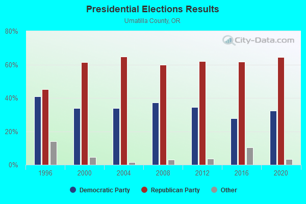
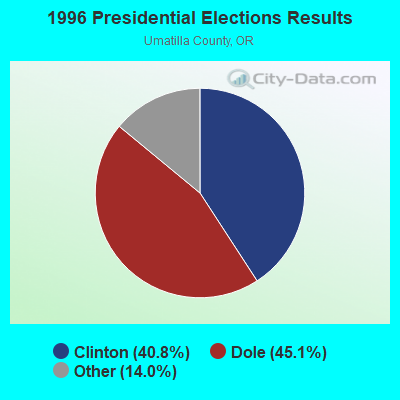

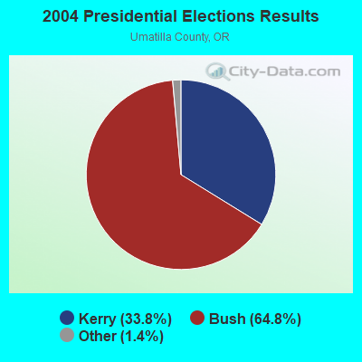
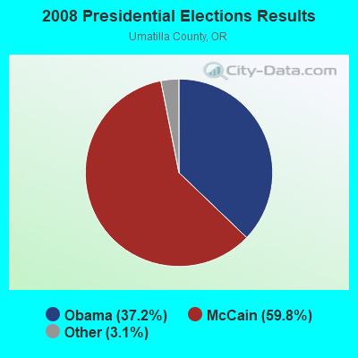

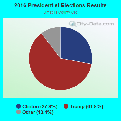
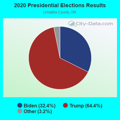
Graphs represent county-level data. Detailed 2008 Election Results
Religion statistics for Reservation, OR (based on Umatilla County data)
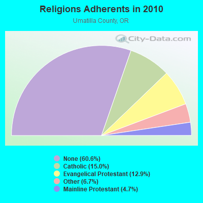
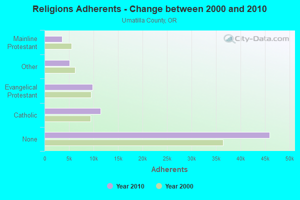
| Religion | Adherents | Congregations |
|---|---|---|
| Catholic | 11,402 | 6 |
| Evangelical Protestant | 9,816 | 75 |
| Other | 5,107 | 17 |
| Mainline Protestant | 3,575 | 24 |
| None | 45,989 | - |
Food Environment Statistics:
| This county: | 2.18 / 10,000 pop. |
| Oregon: | 2.03 / 10,000 pop. |
| Umatilla County: | 0.55 / 10,000 pop. |
| State: | 0.33 / 10,000 pop. |
| Umatilla County: | 1.78 / 10,000 pop. |
| State: | 2.01 / 10,000 pop. |
| Umatilla County: | 1.91 / 10,000 pop. |
| Oregon: | 1.69 / 10,000 pop. |
| Umatilla County: | 7.92 / 10,000 pop. |
| State: | 9.93 / 10,000 pop. |
| This county: | 7.8% |
| Oregon: | 7.4% |
| Umatilla County: | 32.4% |
| Oregon: | 25.6% |
| This county: | 16.9% |
| Oregon: | 14.2% |
Strongest AM radio stations in Reservation:
- KUMA (1290 AM; 5 kW; PENDLETON, OR; Owner: ROUND-UP RADIO, INC.)
- KFLD (870 AM; 10 kW; PASCO, WA; Owner: CAPSTAR TX LIMITED PARTNERSHIP)
- KUJ (1420 AM; 5 kW; WALLA WALLA, WA; Owner: ALEXANDRA COMMUNICATIONS)
- KONA (610 AM; 5 kW; KENNEWICK-RICHLAND-P, WA; Owner: COMMONWEALTH LICENSE SUBSIDIARY, LLC)
- KTIX (1240 AM; 1 kW; PENDLETON, OR; Owner: KSRV, INC.)
- KTBI (810 AM; daytime; 50 kW; EPHRATA, WA; Owner: TACOMA BROADCASTERS, INCORPORATED)
- KWEI (1260 AM; 50 kW; WEISER, ID; Owner: TREASURE VALLEY BROADCASTING CO.)
- KQQQ (1150 AM; 25 kW; PULLMAN, WA; Owner: RADIO PALOUSE, INC.)
- KOHU (1360 AM; 4 kW; HERMISTON, OR; Owner: WESTEND RADIO, LLC)
- KALE (960 AM; 5 kW; RICHLAND, WA; Owner: NEW NORTHWEST BROADCASTERS, LLC)
- KPOJ (620 AM; 50 kW; PORTLAND, OR; Owner: CITICASTERS LICENSES, L.P.)
- KBOI (670 AM; 50 kW; BOISE, ID; Owner: CITADEL BROADCASTING COMPANY)
- KXL (750 AM; 50 kW; PORTLAND, OR; Owner: ROSE CITY RADIO CORPORATION)
Strongest FM radio stations in Reservation:
- KUMA-FM (107.7 FM; PENDLETON, OR; Owner: ROUND-UP RADIO, INC.)
- KOLW (97.9 FM; MILTON-FREEWATER, OR; Owner: CAPSTAR TX LIMITED PARTNERSHIP)
- KRKL (93.3 FM; WALLA WALLA, WA; Owner: EDUCATIONAL MEDIA FOUNDATION)
- KWHT (103.5 FM; PENDLETON, OR; Owner: KSRV, INC.)
- KUBQ (98.7 FM; LA GRANDE, OR; Owner: GRANDE RADIO, INC.)
- KUJ-FM (99.1 FM; WALLA WALLA, WA; Owner: ALEXANDRA COMMUNICATIONS)
- KLRF (88.5 FM; MILTON-FREEWATER, OR; Owner: LIFETALK RADIO, INC.)
- KZZM (101.9 FM; WESTON, OR; Owner: BUTTERFIELD BROADCASTING CORPORATION)
- KNLT (95.7 FM; WALLA WALLA, WA; Owner: NEW NORTHWEST BROADCASTERS, LLC)
- KHSS (100.7 FM; WALLA WALLA, WA; Owner: TWO HEARTS COMMUNICATIONS, LLC)
- KWWS (89.7 FM; WALLA WALLA, WA; Owner: WASHINGTON STATE UNIVERSITY)
- KGTS (91.3 FM; COLLEGE PLACE, WA; Owner: WALLA WALLA COLLEGE)
- KRBM (90.9 FM; PENDLETON, OR; Owner: OREGON PUBLIC BROADCASTING)
- KONA-FM (105.3 FM; KENNEWICK, WA; Owner: COMMONWEALTH LICENSE SUBSIDIARY, LLC)
- K201DH (88.1 FM; PENDLETON, OR; Owner: CALVARY CHAPEL OF TWIN FALLS, INC.)
- KEYW (98.3 FM; PASCO, WA; Owner: CAPSTAR TX LIMITED PARTNERSHIP)
- KCMB (104.7 FM; BAKER, OR; Owner: OREGON TRAIL RADIO, INC.)
- KXRX (97.1 FM; WALLA WALLA, WA; Owner: CAPSTAR TX LIMITED PARTNERSHIP)
- K261CG (100.1 FM; PASCO, WA; Owner: NORTHWEST CHICANO RADIO NETWORK)
- KFAE-FM (89.1 FM; RICHLAND, WA; Owner: WASHINGTON STATE UNIVERSITY)
TV broadcast stations around Reservation:
- K59BO (Channel 59; PENDLETON, ETC., OR; Owner: OREGON PUBLIC BROADCASTING)

- 41.0%Electricity
- 24.5%Wood
- 13.6%Bottled, tank, or LP gas
- 11.9%Utility gas
- 7.9%Fuel oil, kerosene, etc.
- 1.0%Other fuel

- 49.4%Utility gas
- 28.2%Electricity
- 13.3%Wood
- 6.5%Fuel oil, kerosene, etc.
- 2.6%Bottled, tank, or LP gas
Reservation compared to Oregon state average:
- Unemployed percentage below state average.
- Black race population percentage significantly below state average.
- Hispanic race population percentage significantly below state average.
- Foreign-born population percentage significantly below state average.
- Renting percentage significantly below state average.
- Length of stay since moving in significantly above state average.
- Number of rooms per house significantly below state average.
- House age significantly below state average.
- Institutionalized population percentage significantly above state average.
- Percentage of population with a bachelor's degree or higher below state average.