Ramer, Alabama
Submit your own pictures of this place and show them to the world
- OSM Map
- General Map
- Google Map
- MSN Map

| Males: 1,281 | |
| Females: 1,383 |
| Median resident age: | 41.4 years |
| Alabama median age: | 35.8 years |
Zip code: 36069
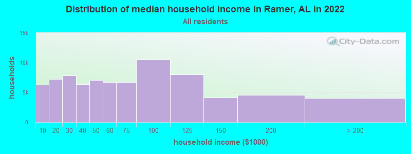
| Ramer: | $50,535 |
| AL: | $59,674 |
Estimated per capita income in 2022: $28,912 (it was $17,777 in 2000)
Ramer CCD income, earnings, and wages data
Estimated median house or condo value in 2022: $147,133 (it was $74,800 in 2000)
| Ramer: | $147,133 |
| AL: | $200,900 |
Mean prices in 2022: all housing units: $222,867; detached houses: $229,373; townhouses or other attached units: $182,167; in 2-unit structures: $200,493; in 3-to-4-unit structures: $161,400; in 5-or-more-unit structures: $64,742; mobile homes: $118,076
Detailed information about poverty and poor residents in Ramer, AL


- 1,61461.2%White alone
- 99537.7%Black alone
- 110.4%Two or more races
- 110.4%Hispanic
- 50.2%American Indian alone
- 20.08%Asian alone

According to our research of Alabama and other state lists, there were 13 registered sex offenders living in Ramer, Alabama as of May 23, 2024.
The ratio of all residents to sex offenders in Ramer is 205 to 1.
 Recent articles from our blog. Our writers, many of them Ph.D. graduates or candidates, create easy-to-read articles on a wide variety of topics.
Current Local Time: CST time zone
Elevation: 476 feet
Land area: 102.4 square miles.
Population density: 26 people per square mile (very low).
| Ramer CCD: | 0.3% ($199) |
| Alabama: | 0.4% ($289) |
Nearest city with pop. 50,000+: Montgomery, AL  (22.9 miles , pop. 201,568).
Nearest city with pop. 1,000,000+: Houston, TX (564.4 miles , pop. 1,953,631).
Nearest cities:
), ), ), ), ), )Latitude: 32.03 N, Longitude: 86.25 W
Area code: 334

| Here: | 2.9% |
| Alabama: | 2.6% |
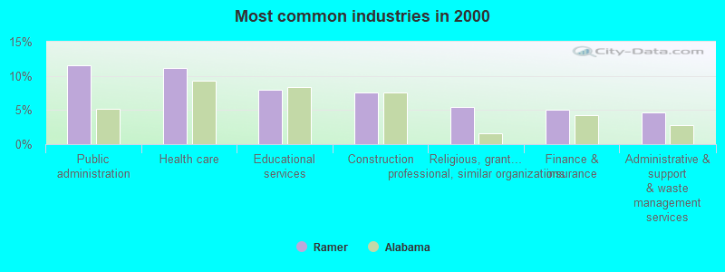
- Public administration (11.6%)
- Health care (11.2%)
- Educational services (8.0%)
- Construction (7.6%)
- Religious, grantmaking, civic, professional, similar organizations (5.5%)
- Finance & insurance (5.0%)
- Administrative & support & waste management services (4.7%)
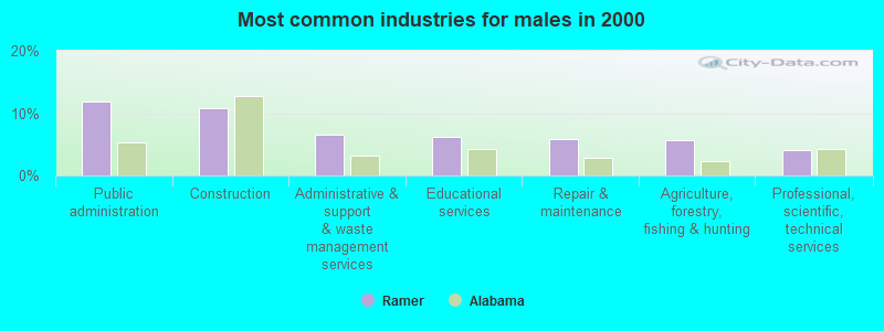
- Public administration (11.8%)
- Construction (10.8%)
- Administrative & support & waste management services (6.5%)
- Educational services (6.2%)
- Repair & maintenance (5.8%)
- Agriculture, forestry, fishing & hunting (5.6%)
- Professional, scientific, technical services (4.1%)
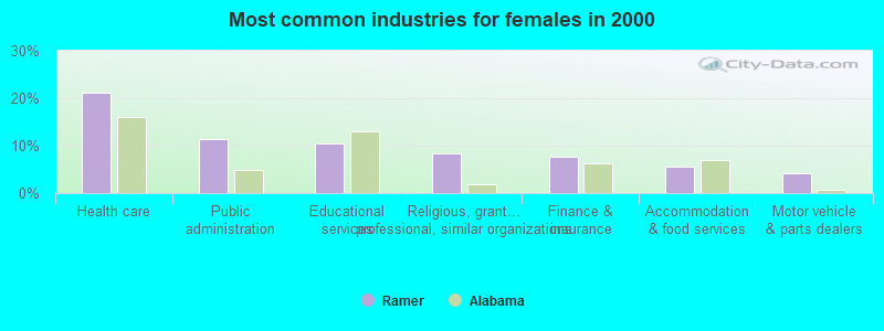
- Health care (21.2%)
- Public administration (11.4%)
- Educational services (10.6%)
- Religious, grantmaking, civic, professional, similar organizations (8.5%)
- Finance & insurance (7.7%)
- Accommodation & food services (5.6%)
- Motor vehicle & parts dealers (4.2%)
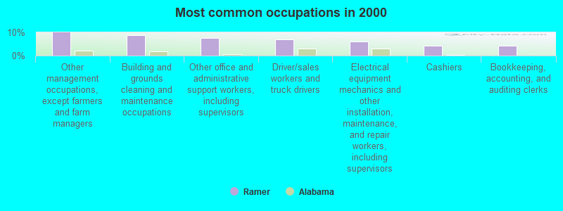
- Other management occupations, except farmers and farm managers (10.0%)
- Building and grounds cleaning and maintenance occupations (8.7%)
- Other office and administrative support workers, including supervisors (7.6%)
- Driver/sales workers and truck drivers (6.9%)
- Electrical equipment mechanics and other installation, maintenance, and repair workers, including supervisors (5.9%)
- Cashiers (4.3%)
- Bookkeeping, accounting, and auditing clerks (4.3%)
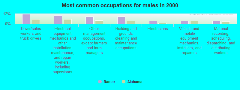
- Driver/sales workers and truck drivers (11.8%)
- Electrical equipment mechanics and other installation, maintenance, and repair workers, including supervisors (10.1%)
- Other management occupations, except farmers and farm managers (8.8%)
- Building and grounds cleaning and maintenance occupations (8.8%)
- Electricians (3.7%)
- Vehicle and mobile equipment mechanics, installers, and repairers (3.7%)
- Material recording, scheduling, dispatching, and distributing workers (3.6%)

- Other office and administrative support workers, including supervisors (14.6%)
- Other management occupations, except farmers and farm managers (11.6%)
- Cashiers (10.3%)
- Bookkeeping, accounting, and auditing clerks (10.3%)
- Building and grounds cleaning and maintenance occupations (8.5%)
- Counselors, social workers, and other community and social service specialists (6.1%)
- Preschool, kindergarten, elementary, and middle school teachers (4.5%)
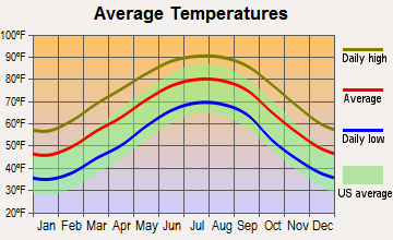
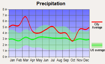
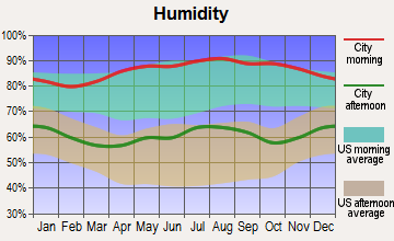
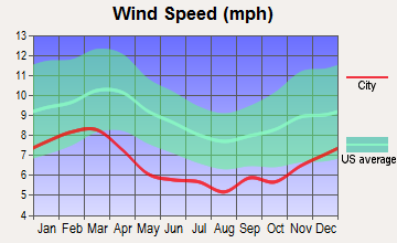
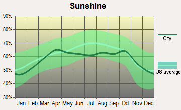
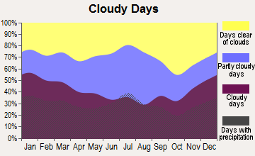
Average climate in Ramer, Alabama
Based on data reported by over 4,000 weather stations

(lower is better)
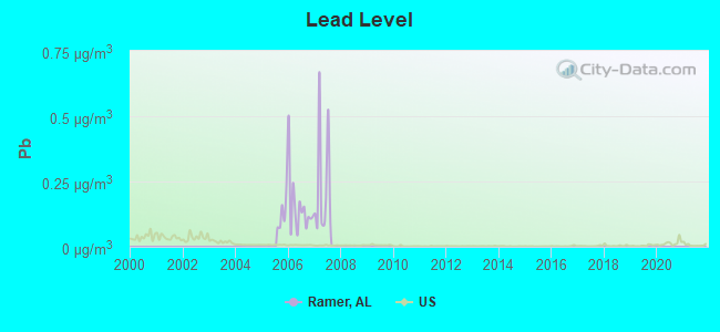
Lead (Pb) [µg/m3] level in 2007 was 0.230. This is significantly worse than average. Closest monitor was 22.7 miles away from the city center.
| City: | 0.230 |
| U.S.: | 0.009 |
Tornado activity:
Ramer-area historical tornado activity is slightly below Alabama state average. It is 38% greater than the overall U.S. average.
On 4/18/1969, a category F4 (max. wind speeds 207-260 mph) tornado 25.0 miles away from the Ramer place center killed 2 people and injured 14 people and caused between $50,000 and $500,000 in damages.
On 12/19/1974, a category F3 (max. wind speeds 158-206 mph) tornado 17.7 miles away from the place center injured one person and caused between $500 and $5000 in damages.
Earthquake activity:
Ramer-area historical earthquake activity is significantly above Alabama state average. It is 53% greater than the overall U.S. average.On 10/24/1997 at 08:35:17, a magnitude 4.9 (4.8 MB, 4.2 MS, 4.9 LG, Depth: 6.2 mi, Class: Light, Intensity: IV - V) earthquake occurred 87.3 miles away from Ramer center
On 1/18/1999 at 07:00:53, a magnitude 4.8 (4.8 MB, 4.0 LG, Depth: 0.6 mi) earthquake occurred 111.6 miles away from the city center
On 4/29/2003 at 08:59:39, a magnitude 4.9 (4.4 MB, 4.6 MW, 4.9 LG) earthquake occurred 174.0 miles away from Ramer center
On 11/7/2004 at 11:20:21, a magnitude 4.3 (4.3 MW, Depth: 3.1 mi) earthquake occurred 107.4 miles away from the city center
On 6/24/1975 at 11:11:36, a magnitude 4.5 (4.5 MB) earthquake occurred 149.0 miles away from the city center
On 4/29/2003 at 08:59:39, a magnitude 4.6 (4.6 MW, Depth: 12.3 mi) earthquake occurred 173.9 miles away from Ramer center
Magnitude types: regional Lg-wave magnitude (LG), body-wave magnitude (MB), surface-wave magnitude (MS), moment magnitude (MW)
Natural disasters:
The number of natural disasters in Montgomery County (15) is near the US average (15).Major Disasters (Presidential) Declared: 9
Emergencies Declared: 5
Causes of natural disasters: Storms: 7, Floods: 5, Hurricanes: 5, Tornadoes: 5, Winds: 3, Drought: 1, Snowfall: 1, Winter Storm: 1, Other: 1 (Note: some incidents may be assigned to more than one category).
Colleges/universities with over 2000 students nearest to Ramer:
- Alabama State University (about 24 miles; Montgomery, AL; Full-time enrollment: 5,457)
- Troy University (about 24 miles; Troy, AL; FT enrollment: 16,148)
- Auburn University at Montgomery (about 24 miles; Montgomery, AL; FT enrollment: 4,092)
- Faulkner University (about 25 miles; Montgomery, AL; FT enrollment: 2,887)
- Tuskegee University (about 42 miles; Tuskegee, AL; FT enrollment: 2,810)
- Enterprise State Community College (about 57 miles; Enterprise, AL; FT enrollment: 2,101)
- Auburn University (about 60 miles; Auburn University, AL; FT enrollment: 22,741)
Public elementary/middle school in Ramer:
- DUNBAR-RAMER SCH (Students: 205, Location: 56 NAFTEL RAMER RD, Grades: PK-8)
Points of interest:
Notable locations in Ramer: Wiggins Farms (A), South Montgomery County Volunteer Fire Department (B). Display/hide their locations on the map
Churches in Ramer include: New Hope Church (A), Pleasant Grove Church (B), Oakdale Church (C), Pleasant Hill Church (D), Sardis Church (E), Weeping Mary Church (F), White Cloud Church (G), Little Zion Church (H), Strata Church of Christ (I). Display/hide their locations on the map
Cemeteries: Sprague Cemetery (1), Fair Prospect Cemetery (2), Fannin Cemetery (3), Philadelphia Cemetery (4), Sentell Cemetery (5), Garner Cemetery (6), Bell Cemetery (7). Display/hide their locations on the map
Lakes and reservoirs: Edwards Ponds (A), Browns Ponds (B), Russells Lake (C), Vinson Ponds (D), Warrs Lake (E), Skinner Lake (F), Leisure Lake (G), Evans Lake (H). Display/hide their locations on the map
Streams, rivers, and creeks: Bedsole Branch (A). Display/hide its location on the map
Tourist attraction: Montgomery City County Publicrary (Cultural Attractions- Events- & Facilities; 5444 State Highway 94) (1). Display/hide its approximate location on the map
Birthplace of: Oscar Gamble - Baseball player.
Drinking water stations with addresses in Ramer and their reported violations in the past:
RAMER WATER COMPANY, INC. (Population served: 1,515, Groundwater):Past monitoring violations:
- Follow-up Or Routine LCR Tap M/R - In JAN-01-1995, Contaminant: Lead and Copper Rule. Follow-up actions: St Violation/Reminder Notice (MAR-04-1996), St Public Notif received (MAY-31-1996)
- 2 routine major monitoring violations
Drinking water stations with addresses in Ramer that have no violations reported:
- PILGRIM-PROVIDENCE WATER AUTHORITY (Population served: 576, Primary Water Source Type: Groundwater)
| This place: | 2.3 people |
| Alabama: | 2.5 people |
| This place: | 67.9% |
| Whole state: | 67.8% |
| This place: | 3.4% |
| Whole state: | 4.7% |
Likely homosexual households (counted as self-reported same-sex unmarried-partner households)
- Lesbian couples: 0.2% of all households
- Gay men: 0.2% of all households
| This place: | 24.1% |
| Whole state: | 16.1% |
| This place: | 9.4% |
| Whole state: | 7.3% |
Banks with branches in Ramer (2011 data):
- Brantley Bank and Trust Company: South Montgomery County Branch at 10 5 Main Street, branch established on 1975/12/15. Info updated 2006/11/03: Bank assets: $65.1 mil, Deposits: $53.9 mil, headquarters in Brantley, AL, positive income, 2 total offices, Holding Company: Brantley Bancorp, Inc.
For population 15 years and over in Ramer:
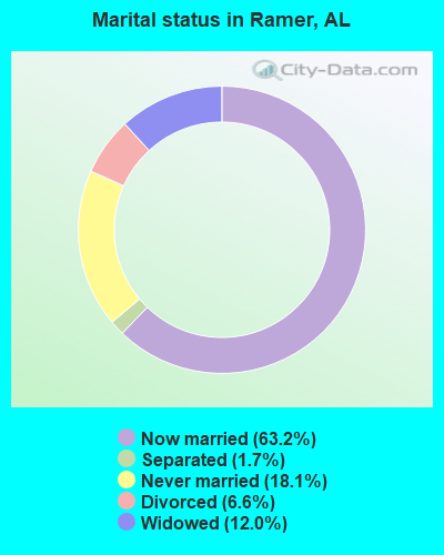
- Never married: 18.1%
- Now married: 63.2%
- Separated: 1.7%
- Widowed: 12.0%
- Divorced: 6.6%
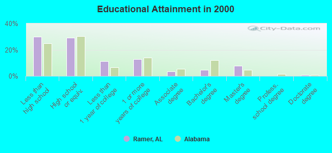
For population 25 years and over in Ramer:
- High school or higher: 70.0%
- Bachelor's degree or higher: 13.5%
- Graduate or professional degree: 8.8%
- Unemployed: 3.3%
- Mean travel time to work (commute): 32.9 minutes
| Here: | 15.1 |
| Alabama average: | 13.2 |
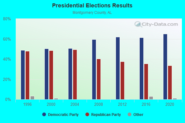
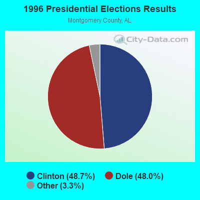
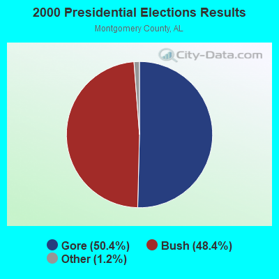
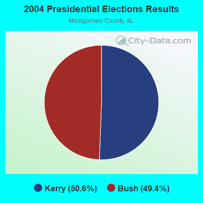
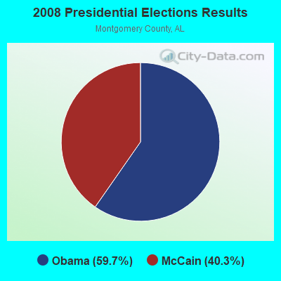
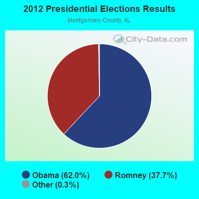
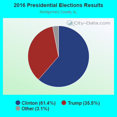
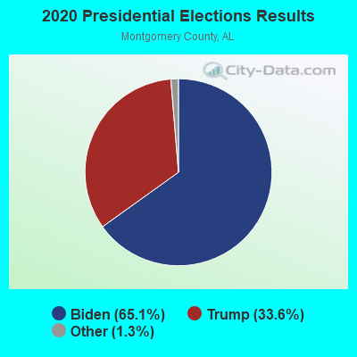
Graphs represent county-level data. Detailed 2008 Election Results
Religion statistics for Ramer, AL (based on Montgomery County data)
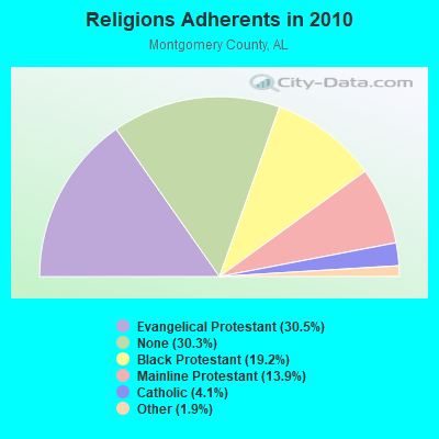
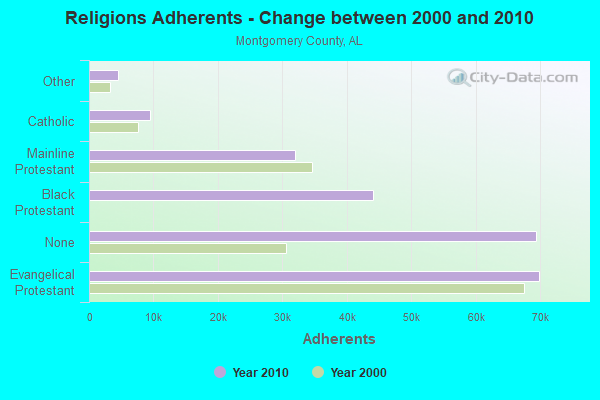
| Religion | Adherents | Congregations |
|---|---|---|
| Evangelical Protestant | 69,894 | 182 |
| Black Protestant | 44,089 | 89 |
| Mainline Protestant | 31,983 | 54 |
| Catholic | 9,480 | 9 |
| Other | 4,424 | 19 |
| Orthodox | 85 | 1 |
| None | 69,408 | - |
Food Environment Statistics:
| Montgomery County: | 1.68 / 10,000 pop. |
| Alabama: | 1.89 / 10,000 pop. |
| This county: | 0.18 / 10,000 pop. |
| Alabama: | 0.20 / 10,000 pop. |
| This county: | 0.35 / 10,000 pop. |
| Alabama: | 0.65 / 10,000 pop. |
| Montgomery County: | 4.78 / 10,000 pop. |
| Alabama: | 6.32 / 10,000 pop. |
| This county: | 6.37 / 10,000 pop. |
| Alabama: | 5.75 / 10,000 pop. |
| Here: | 11.7% |
| Alabama: | 11.8% |
| This county: | 33.0% |
| State: | 31.7% |
| Montgomery County: | 12.0% |
| Alabama: | 13.5% |
6.40% of this county's 2021 resident taxpayers lived in other counties in 2020 ($54,021 average adjusted gross income)
| Here: | 6.40% |
| Alabama average: | 6.87% |
0.09% of residents moved from foreign countries ($1,237 average AGI)
Montgomery County: 0.09% Alabama average: 0.02%
Top counties from which taxpayers relocated into this county between 2020 and 2021:
| from Elmore County, AL | |
| from Autauga County, AL | |
| from Jefferson County, AL |
7.08% of this county's 2020 resident taxpayers moved to other counties in 2021 ($60,559 average adjusted gross income)
| Here: | 7.08% |
| Alabama average: | 6.41% |
0.08% of residents moved to foreign countries ($1,123 average AGI)
Montgomery County: 0.08% Alabama average: 0.02%
Top counties to which taxpayers relocated from this county between 2020 and 2021:
| to Elmore County, AL | |
| to Autauga County, AL | |
| to Jefferson County, AL |
Strongest AM radio stations in Ramer:
- WMSP (740 AM; 10 kW; MONTGOMERY, AL; Owner: CUMULUS LICENSING CORP.)
- WACV (1170 AM; 10 kW; MONTGOMERY, AL; Owner: MONTGOMERY BROADCAST PROPERTIES, LTD)
- WLWI (1440 AM; 5 kW; MONTGOMERY, AL; Owner: CUMULUS LICENSING CORP.)
- WTBF (970 AM; 5 kW; TROY, AL; Owner: TROY BROADCASTING CORP.)
- WJOX (690 AM; 50 kW; BIRMINGHAM, AL; Owner: CITADEL BROADCASTING COMPANY)
- WXVI (1600 AM; 5 kW; MONTGOMERY, AL; Owner: SUNSHINE 16 RADIO NETWORK, INC.)
- WDJC (850 AM; 50 kW; BIRMINGHAM, AL; Owner: KIMTRON, INC.)
- WAPZ (1250 AM; 5 kW; WETUMPKA, AL; Owner: J & W PROMOTIONS, INC.)
- WASG (550 AM; 25 kW; ATMORE, AL; Owner: 550 AM, INC)
- WAPI (1070 AM; 50 kW; BIRMINGHAM, AL; Owner: CITADEL BROADCASTING COMPANY)
- WNSI (810 AM; 50 kW; JACKSONVILLE, AL; Owner: UNITED BROADCASTING NETWORK, INC.)
- WQLS (1200 AM; 10 kW; OZARK, AL; Owner: STYLES BROADCASTING OF DOTHAN, INC.)
- WGST (640 AM; 50 kW; ATLANTA, GA; Owner: CITICASTERS LICENSES, L.P.)
Strongest FM radio stations in Ramer:
- WQLD (104.3 FM; LUVERNE, AL; Owner: CAPSTAR TX LIMITED PARTNERSHIP)
- WZHT (105.7 FM; TROY, AL; Owner: CAPSTAR TX LIMITED PARTNERSHIP)
- WLWI-FM (92.3 FM; MONTGOMERY, AL; Owner: CUMULUS LICENSING CORP.)
- WTSU (89.9 FM; MONTGOMERY-TROY, AL; Owner: TROY STATE UNIVERSITY)
- WAPR (88.3 FM; SELMA, AL; Owner: UA-ASU-TSU EDUCATIONAL RADIO CORP.)
- WBAM-FM (98.9 FM; MONTGOMERY, AL; Owner: DEEP SOUTH BROADCASTING COMPANY)
- WHHY-FM (101.9 FM; MONTGOMERY, AL; Owner: CUMULUS LICENSING CORP.)
- WMCZ (97.1 FM; MILLBROOK, AL; Owner: CAPSTAR TX LIMITED PARTNERSHIP)
- WMXS (103.3 FM; MONTGOMERY, AL; Owner: CUMULUS LICENSING CORP.)
- WQKS-FM (96.1 FM; MONTGOMERY, AL; Owner: MONTGOMERY BROADCAST PROPERTIES, LTD)
- WVAS (90.7 FM; MONTGOMERY, AL; Owner: ALABAMA STATE UNIVERSITY (ASU))
- WAXU (91.1 FM; TROY, AL; Owner: AMERICAN FAMILY ASSOCIATION)
- WKXN (95.9 FM; GREENVILLE, AL; Owner: AUTAUGAVILLE RADIO, INC.)
- WLBF (89.1 FM; MONTGOMERY, AL; Owner: FAITH BROADCASTING, INC)
- WKMX (106.7 FM; ENTERPRISE, AL; Owner: WKMX, INC.)
- WQZX (94.3 FM; GREENVILLE, AL; Owner: HAYNES BROADCASTING, INC.)
- WTBF-FM (94.7 FM; BRUNDIDGE, AL; Owner: TROY BROADCASTING CORPORATION)
- WAOQ (100.3 FM; BRANTLEY, AL; Owner: ALATRON CORPORATION, INC.)
TV broadcast stations around Ramer:
- WRJM-TV (Channel 67; TROY, AL; Owner: JOSIE PARK BROADCASTING, INC.)
- WSFA (Channel 12; MONTGOMERY, AL; Owner: LIBCO, INC.)
- WCOV-TV (Channel 20; MONTGOMERY, AL; Owner: WOODS COMMUNICATIONS CORPORATION)
- WNCF (Channel 32; MONTGOMERY, AL; Owner: CHANNEL 32 MONTGOMERY LLC)
- WAKA (Channel 8; SELMA, AL; Owner: ALABAMA BROADCASTING PARTNERS)
- WMCF-TV (Channel 45; MONTGOMERY, AL; Owner: TRINITY BROADCASTING NETWORK)
- WDIQ (Channel 2; DOZIER, AL; Owner: ALABAMA EDUCATIONAL TELEVISION COMMISSION)
- WETU-LP (Channel 39; WETUMPKA, AL; Owner: CABLE VIDEO PRODUCTIONS, INC.)
- WBIH (Channel 29; SELMA, AL; Owner: FLINN BROADCASTING CORPORATION)
- WAIQ (Channel 26; MONTGOMERY, AL; Owner: ALABAMA EDUCATIONAL TELEVISION COMMISSION)
- W61DH (Channel 61; MONTGOMERY, AL; Owner: FRAZER MEMORIAL UNITED METHODIST CHURCH)
FCC Registered Antenna Towers:
73 (See the full list of FCC Registered Antenna Towers in Ramer)FCC Registered Broadcast Land Mobile Towers:
3- Mike Green Forestry Fire Tower (Lat: 32.114028 Lon: -86.198306), Call Sign: KBI752,
Assigned Frequencies: 151.175 MHz, 151.175 MHz, 159.315 MHz, 159.315 MHz, 159.465 MHz, 159.465 MHz, Grant Date: 06/04/2015, Expiration Date: 08/17/2025, Registrant: Alabama Forestry Commission, 2201 Cong. Dickinson Dr., Montgomery, AL 36109, Phone: (334) 425-5078, Fax: (334) 242-5079, Email:
- Rural Between Al Hwy 94 & Us 331 3.5 Mi Sw (Lat: 32.003750 Lon: -86.258583), Call Sign: KIW48,
Assigned Frequencies: 456.050 MHz, Grant Date: 09/10/2011, Expiration Date: 10/07/2021, Cancellation Date: 12/11/2021, Registrant: Commserv-Inc, Montgomery, AL 36121, Phone: (334) 272-7373, Fax: (334) 244-6499, Email:
- Lat: 32.047750 Lon: -86.225028, Call Sign: WQTV720,
Assigned Frequencies: 467.337 MHz, Grant Date: 04/22/2014, Expiration Date: 04/22/2024, Certifier: Joyce Hubbard, Registrant: Commserv, Inc., Montgomery, AL 36119, Phone: (334) 272-7373, Fax: (334) 244-6488, Email:
FCC Registered Microwave Towers:
15 (See the full list of FCC Registered Microwave Towers in this town)FCC Registered Amateur Radio Licenses:
11 (See the full list of FCC Registered Amateur Radio Licenses in Ramer)FAA Registered Aircraft:
1- Aircraft: ROBERT L BIRD BIRD 1 (Category: Land, Seats: 2, Weight: Up to 12,499 Pounds), Engine: AMA/EXPR UNKNOWN ENG (Reciprocating)
N-Number: 2896T, N2896T, N-2896T, Serial Number: 001, Year manufactured: 2013, Airworthiness Date: 01/24/2013, Certificate Issue Date: 10/27/2018
Registrant (Individual): Matthew P Holston, 9733 Hobbie Rd, Ramer, AL 36069
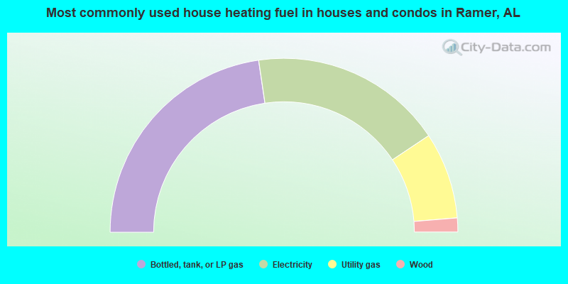
- 45.3%Bottled, tank, or LP gas
- 35.9%Electricity
- 16.1%Utility gas
- 2.6%Wood
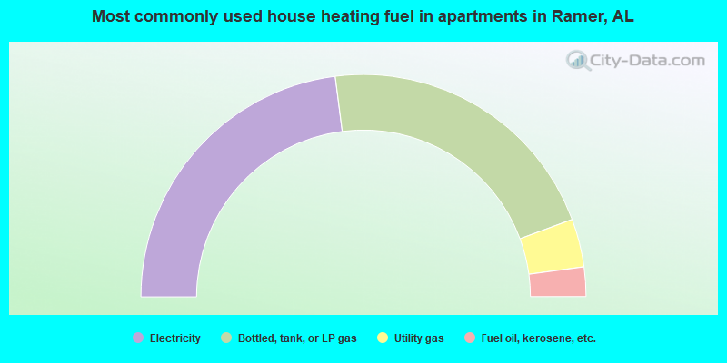
- 46.0%Electricity
- 42.8%Bottled, tank, or LP gas
- 7.0%Utility gas
- 4.3%Fuel oil, kerosene, etc.
Ramer compared to Alabama state average:
- Unemployed percentage significantly below state average.
- Hispanic race population percentage significantly below state average.
- Foreign-born population percentage significantly below state average.
- Renting percentage below state average.
- Length of stay since moving in significantly above state average.
- Number of rooms per house significantly below state average.
- House age significantly below state average.
- Number of college students significantly below state average.
Ramer on our top lists:
- #50 on the list of "Top 101 larger cities with the lowest real estate taxes percentage (population 50,000+)"
- #3 on the list of "Top 101 counties with the worst general health status score of residents (1-5), 3 years of data"
- #16 on the list of "Top 101 counties with the most Black Protestant adherents"
- #22 on the list of "Top 101 counties with the most Black Protestant congregations"
- #28 on the list of "Top 101 counties with the lowest percentage of residents that visited a dentist within the past year"
- #38 on the list of "Top 101 counties with the lowest percentage of residents that exercised in the past month"