Puerco, Arizona
Submit your own pictures of this place and show them to the world
- OSM Map
- General Map
- Google Map
- MSN Map

| Males: 1,022 | |
| Females: 1,068 |
| Median resident age: | 24.8 years |
| Arizona median age: | 34.2 years |
Zip code: 86512
| Puerco: | $35,966 |
| AZ: | $74,568 |
Estimated per capita income in 2022: $20,116 (it was $8,722 in 2000)
Puerco CCD income, earnings, and wages data
Estimated median house or condo value in 2022: $121,854 (it was $71,400 in 2000)
| Puerco: | $121,854 |
| AZ: | $402,800 |
Mean prices in 2022: all housing units: $131,025; detached houses: $148,206; townhouses or other attached units: $108,704; mobile homes: $81,811; occupied boats, rvs, vans, etc.: $11,371
Detailed information about poverty and poor residents in Puerco, AZ


- 1,69580.8%American Indian alone
- 28113.4%White alone
- 753.6%Hispanic
- 371.8%Two or more races
- 80.4%Black alone
- 10.05%Asian alone
- 10.05%Native Hawaiian and Other
Pacific Islander alone

 Recent articles from our blog. Our writers, many of them Ph.D. graduates or candidates, create easy-to-read articles on a wide variety of topics.
Current Local Time: MST (no DST) time zone
Land area: 1618.9 square miles.
Population density: 1.3 people per square mile (very low).

| Puerco CCD: | 0.5% ($369) |
| Arizona: | 0.9% ($962) |
Nearest city with pop. 50,000+: Coconino, AZ (115.4 miles  , pop. 74,488).
Nearest city with pop. 200,000+: Albuquerque, NM (162.7 miles , pop. 448,607).
Nearest city with pop. 1,000,000+: Phoenix, AZ (178.7 miles , pop. 1,321,045).
Nearest cities:
), Latitude: 34.96 N, Longitude: 109.48 W
Area code commonly used in this area: 928


Puerco tourist attractions:
| Here: | 7.3% |
| Arizona: | 3.8% |

- Educational services (27.3%)
- Construction (15.6%)
- Public administration (12.1%)
- Social assistance (6.2%)
- Accommodation & food services (4.5%)
- Real estate & rental & leasing (3.8%)
- Gasoline stations (2.8%)

- Construction (29.1%)
- Educational services (22.6%)
- Real estate & rental & leasing (6.0%)
- Public administration (5.3%)
- Agriculture, forestry, fishing & hunting (3.8%)
- Mining, quarrying, oil & gas extraction (3.0%)
- Rail transportation (3.0%)

- Educational services (32.0%)
- Public administration (18.8%)
- Social assistance (12.4%)
- Accommodation & food services (6.8%)
- Gasoline stations (5.6%)
- Health care (4.9%)
- Food & beverage stores (3.4%)

- Preschool, kindergarten, elementary, and middle school teachers (16.6%)
- Cashiers (7.0%)
- Construction laborers (6.0%)
- Building and grounds cleaning and maintenance occupations (5.8%)
- Other construction workers and helpers (4.9%)
- Driver/sales workers and truck drivers (4.7%)
- Other sales and related occupations, including supervisors (4.1%)

- Preschool, kindergarten, elementary, and middle school teachers (15.1%)
- Construction laborers (12.1%)
- Other construction workers and helpers (9.8%)
- Other sales and related occupations, including supervisors (6.0%)
- Electrical equipment mechanics and other installation, maintenance, and repair workers, including supervisors (4.5%)
- Vehicle and mobile equipment mechanics, installers, and repairers (4.2%)
- Laborers and material movers, hand (4.2%)

- Preschool, kindergarten, elementary, and middle school teachers (18.0%)
- Cashiers (12.8%)
- Building and grounds cleaning and maintenance occupations (7.9%)
- Counselors, social workers, and other community and social service specialists (7.5%)
- Driver/sales workers and truck drivers (6.0%)
- Information and record clerks, except customer service representatives (5.6%)
- Secretaries and administrative assistants (5.6%)
Average climate in Puerco, Arizona
Based on data reported by over 4,000 weather stations


Earthquake activity:
Puerco-area historical earthquake activity is significantly above Arizona state average. It is 1381% greater than the overall U.S. average.On 6/28/1992 at 11:57:34, a magnitude 7.6 (6.2 MB, 7.6 MS, 7.3 MW, Depth: 0.7 mi, Class: Major, Intensity: VIII - XII) earthquake occurred 405.3 miles away from Puerco center, causing 3 deaths (1 shaking deaths, 2 other deaths) and 400 injuries, causing $100,000,000 total damage and $40,000,000 insured losses
On 10/16/1999 at 09:46:44, a magnitude 7.4 (6.3 MB, 7.4 MS, 7.2 MW, 7.3 ML) earthquake occurred 396.6 miles away from the city center
On 5/19/1940 at 04:36:40, a magnitude 7.2 (7.2 UK) earthquake occurred 376.0 miles away from Puerco center, causing $33,000,000 total damage
On 12/31/1934 at 18:45:56, a magnitude 7.1 (7.1 UK) earthquake occurred 393.8 miles away from the city center
On 10/15/1979 at 23:16:54, a magnitude 7.0 (5.7 MB, 6.9 MS, 7.0 ML, 6.4 MW) earthquake occurred 383.6 miles away from Puerco center
On 7/21/1952 at 11:52:14, a magnitude 7.7 (7.7 UK) earthquake occurred 539.5 miles away from Puerco center, causing $50,000,000 total damage
Magnitude types: body-wave magnitude (MB), local magnitude (ML), surface-wave magnitude (MS), moment magnitude (MW)
Natural disasters:
The number of natural disasters in Apache County (12) is smaller than the US average (15).Major Disasters (Presidential) Declared: 6
Emergencies Declared: 3
Causes of natural disasters: Floods: 4, Fires: 3, Storms: 3, Winter Storms: 2, Drought: 1, Flash Flood: 1, Heavy Rain: 1, Hurricane: 1, Tornado: 1, Other: 1 (Note: some incidents may be assigned to more than one category).
Colleges/universities with over 2000 students nearest to Puerco:
- Coconino Community College (about 124 miles; Flagstaff, AZ; Full-time enrollment: 2,090)
- Northern Arizona University (about 125 miles; Flagstaff, AZ; FT enrollment: 22,494)
- San Juan College (about 146 miles; Farmington, NM; FT enrollment: 5,112)
- Eastern Arizona College (about 148 miles; Thatcher, AZ; FT enrollment: 3,810)
- Northcentral University (about 162 miles; Prescott Valley, AZ; FT enrollment: 5,927)
- Central New Mexico Community College (about 162 miles; Albuquerque, NM; FT enrollment: 19,398)
- University of New Mexico-Main Campus (about 163 miles; Albuquerque, NM; FT enrollment: 23,042)
Points of interest:
Notable locations in Puerco: Good Luck Well (A), Peplote Windmill (B), Platts Windmill (C), Beacon Well (D), Potter Windmill (E), High Lonesome Well (F), White Well (G), Rattlesnake Windmill (H), Bobcat Windmill (I), Witch Well Ranch (J), River Windmill (K), Roberts Ranch (L), Chambers Windmill (M), Seventeen Windmill (N), Little Wallace Windmill (O), Long H Ranch (P), Sleepy Hollow Windmill (Q), Arizona State Inspection Station (R), Puerco Pueblo (S), Crows Nest Windmill (T). Display/hide their locations on the map
Cemetery: McCarrell Memorial Cemetery (1). Display/hide its location on the map
Lakes and reservoirs: Michigan Lake (A), Wild Cow Lake (B), Deep Lake (C), Red Lake (D), Long Tree Lake (E), Red Lake (F), Barth Lake (G), Deer Tank (H). Display/hide their locations on the map
Streams, rivers, and creeks: Brown Wash (A), Crazy Creek (B), Cedar Lake Wash (C), Dead Wash (D), Little Milky Wash (E), Seven Springs Wash (F), Teds Wash (G), East Fork Dry Creek (H), Beaver Dam Wash (I). Display/hide their locations on the map
Parks in Puerco include: Territorial Government Formation Site Historical Monument (1), Petrified Forest National Park (2). Display/hide their locations on the map
| This place: | 3.2 people |
| Arizona: | 2.6 people |
| This place: | 70.6% |
| Whole state: | 66.2% |
| This place: | 7.9% |
| Whole state: | 7.8% |
Likely homosexual households (counted as self-reported same-sex unmarried-partner households)
- Lesbian couples: 0.4% of all households
- Gay men: 0.4% of all households
| This place: | 35.9% |
| Whole state: | 13.9% |
| This place: | 11.6% |
| Whole state: | 6.2% |
For population 15 years and over in Puerco:

- Never married: 39.1%
- Now married: 49.6%
- Separated: 2.9%
- Widowed: 6.2%
- Divorced: 5.0%
For population 25 years and over in Puerco:
- High school or higher: 68.4%
- Bachelor's degree or higher: 10.1%
- Graduate or professional degree: 2.6%
- Unemployed: 18.2%
- Mean travel time to work (commute): 33.2 minutes


| Here: | 23.0 |
| Arizona average: | 13.1 |
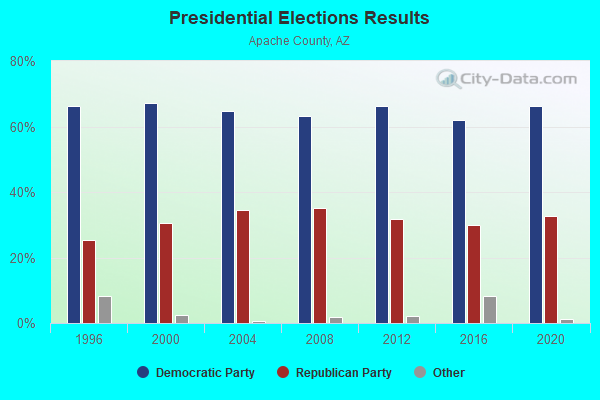
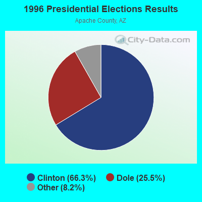
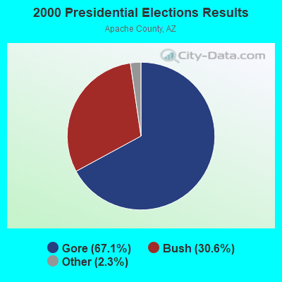
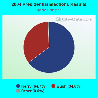
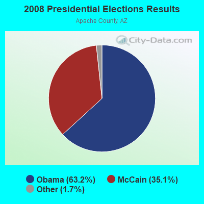
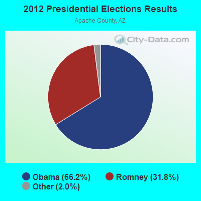
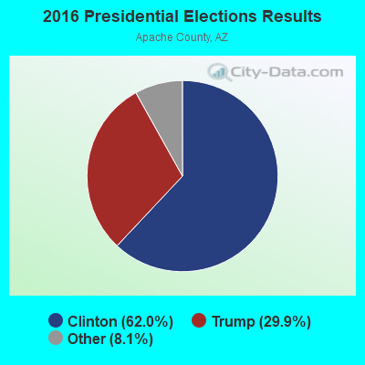
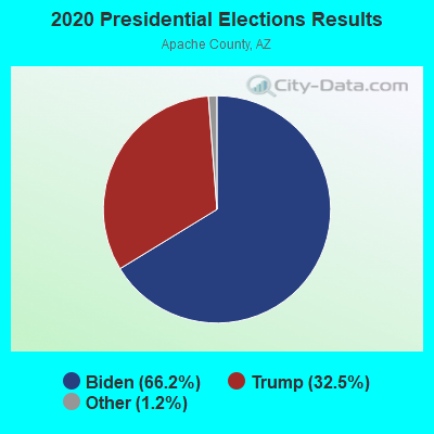
Graphs represent county-level data. Detailed 2008 Election Results
Religion statistics for Puerco, AZ (based on Apache County data)
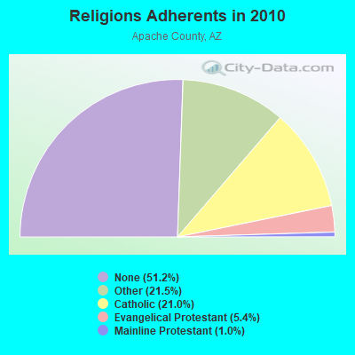
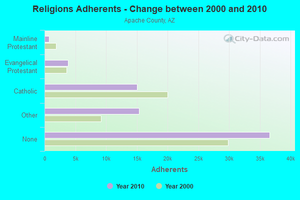
| Religion | Adherents | Congregations |
|---|---|---|
| Other | 15,377 | 35 |
| Catholic | 15,000 | 13 |
| Evangelical Protestant | 3,834 | 73 |
| Mainline Protestant | 715 | 11 |
| None | 36,592 | - |
Food Environment Statistics:
| Apache County: | 1.58 / 10,000 pop. |
| State: | 1.36 / 10,000 pop. |
| Here: | 0.57 / 10,000 pop. |
| State: | 0.55 / 10,000 pop. |
| Here: | 4.74 / 10,000 pop. |
| Arizona: | 2.47 / 10,000 pop. |
| This county: | 2.87 / 10,000 pop. |
| Arizona: | 6.21 / 10,000 pop. |
| Apache County: | 12.8% |
| Arizona: | 8.0% |
| This county: | 31.5% |
| Arizona: | 22.8% |
| Apache County: | 10.2% |
| Arizona: | 14.2% |
Strongest AM radio stations in Puerco:
- KHAC (880 AM; 43 kW; TSE BONITO, NM; Owner: WESTERN INDIAN MINISTRIES, INC.)
- KTNN (660 AM; 50 kW; WINDOW ROCK, AZ; Owner: THE NAVAJO NATION)
- KMIA (710 AM; 50 kW; BLACK CANYON CITY, AZ; Owner: ENTRAVISION HOLDINGS, LLC)
- KDJI (1270 AM; 5 kW; HOLBROOK, AZ; Owner: PETRACOM OF HOLBROOK, L.L.C.)
- KFNX (1100 AM; 50 kW; CAVE CREEK, AZ; Owner: NORTH AMERICAN BROADCASTING CO., INC.)
- KKOB (770 AM; 50 kW; ALBUQUERQUE, NM; Owner: CITADEL BROADCASTING COMPANY)
- KFLT (830 AM; 50 kW; TUCSON, AZ; Owner: FAMILY LIFE B/CING SYSTEM, INC.)
- KVWM (970 AM; 5 kW; SHOW LOW, AZ; Owner: PETRACOM OF SHOW LOW, LLC)
- KGAK (1330 AM; 5 kW; GALLUP, NM; Owner: KRJG, INC.)
- KMIK (1580 AM; 50 kW; TEMPE, AZ; Owner: ABC, INC.)
- KPXQ (1360 AM; 50 kW; GLENDALE, AZ; Owner: COMMON GROUND BROADCASTING, INC.)
- KUAZ (1550 AM; daytime; 50 kW; TUCSON, AZ; Owner: ARIZONA BOARD OF REGENTS)
- KDWN (720 AM; 50 kW; LAS VEGAS, NV; Owner: RADIO NEVADA CORP.)
Strongest FM radio stations in Puerco:
- KWKM (95.7 FM; ST. JOHNS, AZ; Owner: KM RADIO OF ST. JOHNS, L.L.C.)
- KTHQ (92.5 FM; EAGAR, AZ; Owner: COUNTRY MOUNTAIN AIRWAVES, LLC)
TV broadcast stations around Puerco:
- K08HQ (Channel 8; CHINLE, AZ; Owner: KOB-TV, LLC)
- National Bridge Inventory (NBI) Statistics
- 1Number of bridges
- 3ft / 1.2mTotal length
- 1,382Total average daily traffic
- 152Total average daily truck traffic
- 1,392Total future (year 2038) average daily traffic

- 71.6%Wood
- 23.5%Bottled, tank, or LP gas
- 4.9%Electricity

- 49.5%Wood
- 30.9%Bottled, tank, or LP gas
- 11.7%Electricity
- 8.0%Utility gas
Puerco compared to Arizona state average:
- Median household income below state average.
- Median house value significantly below state average.
- Black race population percentage significantly below state average.
- Hispanic race population percentage significantly below state average.
- Median age significantly below state average.
- Foreign-born population percentage significantly below state average.
- Length of stay since moving in significantly above state average.
- Number of rooms per house significantly below state average.
- House age significantly below state average.
- Percentage of population with a bachelor's degree or higher below state average.
Puerco on our top lists:
- #78 on the list of "Top 100 cities with largest land areas"
- #2 on the list of "Top 101 counties with the lowest Particulate Matter (PM2.5) Annual air pollution readings in 2012 (µg/m3)"
- #29 on the list of "Top 101 counties with the largest increase in the number of deaths per 1000 residents 2000-2006 to 2007-2013 (pop. 50,000+)"
- #75 on the list of "Top 101 counties with the highest percentage of residents relocating from other counties between 2010 and 2011 (pop. 50,000+)"
- #78 on the list of "Top 101 counties with highest percentage of residents voting for Obama (Democrat) in the 2012 Presidential Election (pop. 50,000+)"
- #84 on the list of "Top 101 counties with the highest percentage of residents relocating to other counties in 2011 (pop. 50,000+)"