Omaha, Georgia
Submit your own pictures of this place and show them to the world
- OSM Map
- General Map
- Google Map
- MSN Map

| Males: 782 | |
| Females: 829 |
| Median resident age: | 37.2 years |
| Georgia median age: | 33.4 years |
Zip code: 31815
| Omaha: | $41,183 |
| GA: | $72,837 |
Estimated per capita income in 2022: $20,422 (it was $15,338 in 2000)
Omaha CCD income, earnings, and wages data
Estimated median house or condo value in 2022: $80,885 (it was $34,500 in 2000)
| Omaha: | $80,885 |
| GA: | $297,400 |
Mean prices in 2022: all housing units: $90,091; detached houses: $131,437; mobile homes: $25,765
Detailed information about poverty and poor residents in Omaha, GA


- 1,31771.4%Black alone
- 50227.2%White alone
- 160.9%Hispanic
- 80.4%American Indian alone
- 20.1%Two or more races
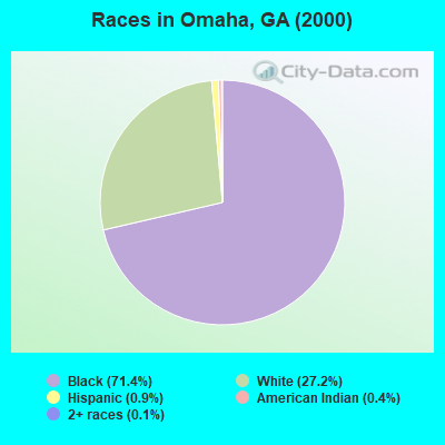
Races in Omaha detailed stats: ancestries, foreign born residents, place of birth
According to our research of Georgia and other state lists, there were 3 registered sex offenders living in Omaha, Georgia as of May 23, 2024.
The ratio of all residents to sex offenders in Omaha is 537 to 1.
The ratio of registered sex offenders to all residents in this city is lower than the state average.
 Recent articles from our blog. Our writers, many of them Ph.D. graduates or candidates, create easy-to-read articles on a wide variety of topics.
Current Local Time: EST time zone
Elevation: 310 feet
Land area: 184.9 square miles.
Population density: 8.7 people per square mile (very low).

| Omaha CCD: | 1.1% ($366) |
| Georgia: | 0.9% ($919) |
Nearest city with pop. 50,000+: Columbus, GA  (24.9 miles , pop. 185,781).
Nearest city with pop. 200,000+: Montgomery, AL (83.4 miles , pop. 201,568).
Nearest city with pop. 1,000,000+: Houston, TX (644.0 miles , pop. 1,953,631).
Nearest cities:
), ), ), ), )Latitude: 32.13 N, Longitude: 84.88 W
Area code commonly used in this area: 229

| Here: | 2.8% |
| Georgia: | 2.9% |
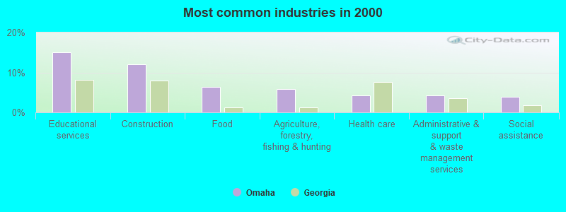
- Educational services (15.1%)
- Construction (12.0%)
- Food (6.3%)
- Agriculture, forestry, fishing & hunting (5.9%)
- Health care (4.2%)
- Administrative & support & waste management services (4.2%)
- Social assistance (3.9%)

- Construction (21.0%)
- Agriculture, forestry, fishing & hunting (10.2%)
- Educational services (7.5%)
- Administrative & support & waste management services (5.9%)
- Wood products (5.1%)
- Food (4.3%)
- Truck transportation (4.0%)
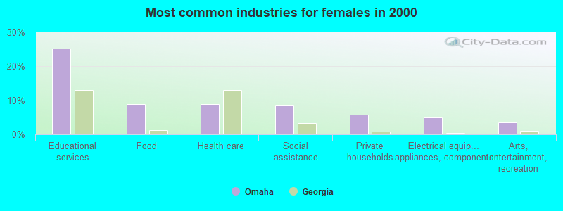
- Educational services (25.2%)
- Food (9.0%)
- Health care (9.0%)
- Social assistance (8.6%)
- Private households (5.8%)
- Electrical equipment, appliances, components (5.0%)
- Arts, entertainment, recreation (3.6%)

- Other production occupations, including supervisors (10.9%)
- Preschool, kindergarten, elementary, and middle school teachers (6.2%)
- Textile, apparel, and furnishings workers (5.2%)
- Cooks and food preparation workers (4.0%)
- Fishing, hunting, and forestry occupations (3.9%)
- Building and grounds cleaning and maintenance occupations (3.9%)
- Painters and paperhangers (3.5%)

- Other production occupations, including supervisors (14.3%)
- Fishing, hunting, and forestry occupations (6.7%)
- Painters and paperhangers (6.2%)
- Electrical equipment mechanics and other installation, maintenance, and repair workers, including supervisors (4.9%)
- Driver/sales workers and truck drivers (4.3%)
- Construction traders workers except carpenters, electricians, painters, plumbers, and construction laborers (4.0%)
- Supervisors, construction and extraction workers (4.0%)

- Preschool, kindergarten, elementary, and middle school teachers (13.3%)
- Textile, apparel, and furnishings workers (7.9%)
- Building and grounds cleaning and maintenance occupations (6.8%)
- Other production occupations, including supervisors (6.5%)
- Counselors, social workers, and other community and social service specialists (5.8%)
- Cooks and food preparation workers (5.8%)
- Laborers and material movers, hand (4.7%)
Average climate in Omaha, Georgia
Based on data reported by over 4,000 weather stations


Tornado activity:
Omaha-area historical tornado activity is slightly above Georgia state average. It is 40% greater than the overall U.S. average.
On 3/13/1954, a category F3 (max. wind speeds 158-206 mph) tornado 16.2 miles away from the Omaha place center killed 2 people and injured 20 people and caused between $5,000,000 and $50,000,000 in damages.
On 3/31/1961, a category F3 tornado 22.3 miles away from the place center injured 7 people and caused between $5000 and $50,000 in damages.
Earthquake activity:
Omaha-area historical earthquake activity is significantly above Georgia state average. It is 21% greater than the overall U.S. average.On 10/24/1997 at 08:35:17, a magnitude 4.9 (4.8 MB, 4.2 MS, 4.9 LG, Depth: 6.2 mi, Class: Light, Intensity: IV - V) earthquake occurred 157.3 miles away from Omaha center
On 4/29/2003 at 08:59:39, a magnitude 4.9 (4.4 MB, 4.6 MW, 4.9 LG) earthquake occurred 168.9 miles away from the city center
On 8/2/1974 at 08:52:09, a magnitude 4.9 (4.3 MB, 4.9 LG) earthquake occurred 183.5 miles away from Omaha center
On 1/18/1999 at 07:00:53, a magnitude 4.8 (4.8 MB, 4.0 LG, Depth: 0.6 mi) earthquake occurred 163.8 miles away from Omaha center
On 4/29/2003 at 08:59:39, a magnitude 4.6 (4.6 MW, Depth: 12.3 mi) earthquake occurred 168.9 miles away from the city center
On 6/24/1975 at 11:11:36, a magnitude 4.5 (4.5 MB) earthquake occurred 203.9 miles away from Omaha center
Magnitude types: regional Lg-wave magnitude (LG), body-wave magnitude (MB), surface-wave magnitude (MS), moment magnitude (MW)
Natural disasters:
The number of natural disasters in Stewart County (10) is smaller than the US average (15).Major Disasters (Presidential) Declared: 7
Emergencies Declared: 2
Causes of natural disasters: Floods: 4, Storms: 4, Tornadoes: 4, Hurricanes: 3, Drought: 1, Heavy Rain: 1, Tropical Storm: 1, Other: 1 (Note: some incidents may be assigned to more than one category).
Colleges/universities with over 2000 students nearest to Omaha:
- Columbus State University (about 26 miles; Columbus, GA; Full-time enrollment: 6,876)
- Columbus Technical College (about 27 miles; Columbus, GA; FT enrollment: 3,241)
- Georgia Southwestern State University (about 40 miles; Americus, GA; FT enrollment: 2,689)
- Auburn University (about 49 miles; Auburn University, AL; FT enrollment: 22,741)
- Tuskegee University (about 53 miles; Tuskegee, AL; FT enrollment: 2,810)
- Darton State College (about 55 miles; Albany, GA; FT enrollment: 5,000)
- Albany Technical College (about 58 miles; Albany, GA; FT enrollment: 3,707)
Points of interest:
Notable locations in Omaha: McMurrons Landing (A), Fitzgeralds Landing (B), Banks Landing (C), Marvins Store (D), Lawsons Landing (E), Lumpkin Volunteer Fire Department (F), Louvale Community Fire Department (G), Stewart County Courthouse (H). Display/hide their locations on the map
Churches in Omaha include: Ebenezer Church (A), Mount Gilead Church (B), Mount Moriah Church (C), Mount Olive Church (D), Mount Zion Church (E), New Hope Church (F), Pleasant Grove Church (G), Greater New Hope Church (H), Saint Marks Church (I). Display/hide their locations on the map
Cemeteries: Armour Cemetery (1), Mathis Cemetery (2), East Side Cemetery (3), Florence Cemetery (4), North Side Cemetery (5), Trinity Cemetery (6), Ebenezer Cemetery (7). Display/hide their locations on the map
Reservoirs: Perkins Lake (A), Davis Pond (B), Elders Pond (C), Gordys Pond (D), Hallidays Pond (E), Holders Pond (F), Jenkins Pond (G), Ushers Millpond (H). Display/hide their locations on the map
Streams, rivers, and creeks: Hightower Branch (A), Sand Branch (B), Grass Creek (C), Hannahatchee Creek (D), Frog Bottom Creek (E), Colochee Creek (F), Bussey Branch (G), Broach Creek (H), Black Creek (I). Display/hide their locations on the map
Parks in Omaha include: East Main Street Residential Historic District (1), Hannahatchee Wildlife Management Area (2), Lumpkin Commercial Historic District (3), Louvale Church Row Historic District (4), Florence Marina State Park (5), Sheppard Plantation Battle Monument (6), Florence Landing Recreation Area (7). Display/hide their locations on the map
| This place: | 2.5 people |
| Georgia: | 2.6 people |
| This place: | 67.1% |
| Whole state: | 68.5% |
| This place: | 6.5% |
| Whole state: | 5.9% |
Likely homosexual households (counted as self-reported same-sex unmarried-partner households)
- Lesbian couples: 0.6% of all households
- Gay men: 0.2% of all households
| This place: | 23.9% |
| Whole state: | 13.0% |
| This place: | 9.7% |
| Whole state: | 6.1% |
For population 15 years and over in Omaha:
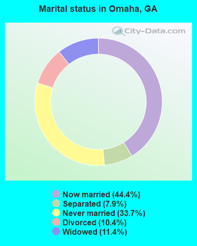
- Never married: 33.7%
- Now married: 44.4%
- Separated: 7.9%
- Widowed: 11.4%
- Divorced: 10.4%
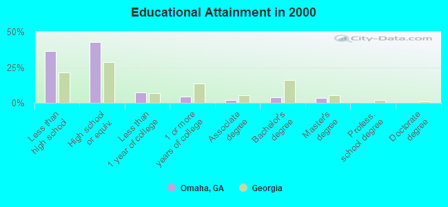
For population 25 years and over in Omaha:
- High school or higher: 63.7%
- Bachelor's degree or higher: 7.5%
- Graduate or professional degree: 3.4%
- Unemployed: 11.2%
- Mean travel time to work (commute): 31.9 minutes
| Here: | 16.1 |
| Georgia average: | 13.3 |
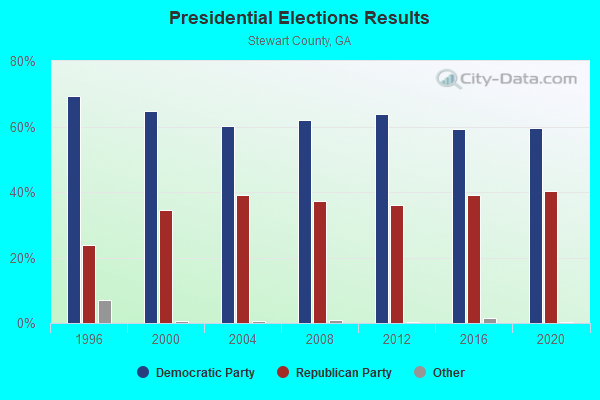
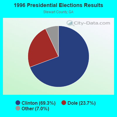
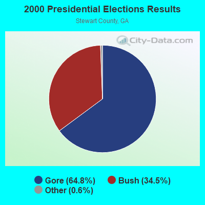

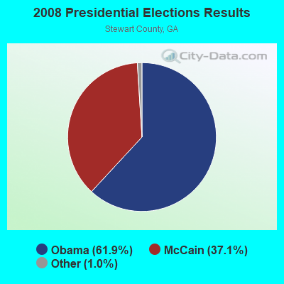
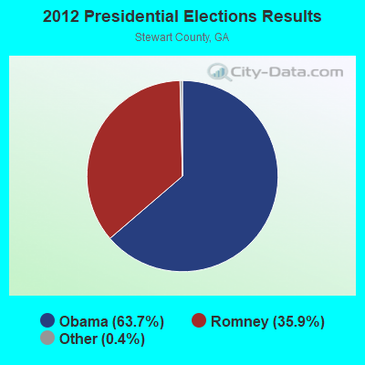
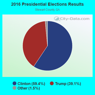
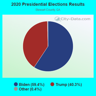
Graphs represent county-level data. Detailed 2008 Election Results
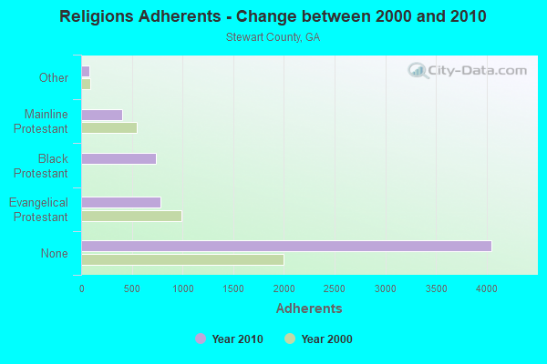
Religion statistics for Omaha, GA (based on Stewart County data)
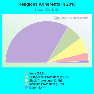
| Religion | Adherents | Congregations |
|---|---|---|
| Evangelical Protestant | 782 | 8 |
| Black Protestant | 733 | 6 |
| Mainline Protestant | 408 | 7 |
| Other | 84 | - |
| None | 4,051 | - |
Food Environment Statistics:
| Stewart County: | 2.15 / 10,000 pop. |
| State: | 1.91 / 10,000 pop. |
| Stewart County: | 2.15 / 10,000 pop. |
| Georgia: | 0.86 / 10,000 pop. |
| Stewart County: | 10.77 / 10,000 pop. |
| State: | 5.12 / 10,000 pop. |
| Here: | 8.62 / 10,000 pop. |
| Georgia: | 7.41 / 10,000 pop. |
| Stewart County: | 16.6% |
| State: | 10.4% |
| This county: | 33.1% |
| State: | 27.8% |
| Stewart County: | 10.7% |
| State: | 14.6% |
Strongest AM radio stations in Omaha:
- WDAK (540 AM; 5 kW; COLUMBUS, GA; Owner: CLEAR CHANNEL BROADCASTING LICENSES, INC.)
- WMLF (1270 AM; 5 kW; COLUMBUS, GA; Owner: CLEAR CHANNEL BROADCASTING LICENSES, INC.)
- WMAC (940 AM; 50 kW; MACON, GA; Owner: CUMULUS LICENSING CORP.)
- WHAL (1460 AM; 4 kW; PHENIX CITY/COLUMBUS, AL; Owner: CLEAR CHANNEL BROADCASTING LICENSES, INC.)
- WGST (640 AM; 50 kW; ATLANTA, GA; Owner: CITICASTERS LICENSES, L.P.)
- WRCG (1420 AM; 5 kW; COLUMBUS, GA; Owner: ABG GEORGIA, LLC)
- WSB (750 AM; 50 kW; ATLANTA, GA; Owner: CXR HOLDINGS, INC.)
- WCNN (680 AM; 50 kW; NORTH ATLANTA, GA; Owner: DICKEY BROADCASTING COMPANY)
- WGUN (1010 AM; 50 kW; ATLANTA, GA; Owner: WGUN, INC.)
- WKNG (1060 AM; daytime; 50 kW; TALLAPOOSA, GA; Owner: WKNG, INC.)
- WNSI (810 AM; 50 kW; JACKSONVILLE, AL; Owner: UNITED BROADCASTING NETWORK, INC.)
- WMLB (1160 AM; 50 kW; EAST POINT, GA; Owner: ATLANTA AREA BROADCASTING, INC.)
- WJOX (690 AM; 50 kW; BIRMINGHAM, AL; Owner: CITADEL BROADCASTING COMPANY)
Strongest FM radio stations in Omaha:
- WKCN (99.3 FM; LUMPKIN, GA; Owner: ABG GEORGIA, LLC)
- WCGQ (107.3 FM; COLUMBUS, GA; Owner: ABG GEORGIA, LLC)
- WEAM-FM (100.7 FM; BUENA VISTA, GA; Owner: DAVIS BROADCASTING INC., OF COLUMBUS)
- WIOL (92.7 FM; EUFAULA, AL; Owner: HATCHEE CREEK COMMUNICATIONS, INC.)
- WVFJ-FM (93.3 FM; MANCHESTER, GA; Owner: PROVIDENT BROADCASTING COMPANY)
- WAGH (98.3 FM; FORT MITCHELL, AL; Owner: CLEAR CHANNEL BROADCASTING LICENSES, INC.)
- WRVX (97.9 FM; EUFAULA, AL; Owner: RIVER VALLEY MEDIA, L.L.C.)
- W220BI (91.9 FM; EUFAULA, AL; Owner: MONTGOMERY CHRISTIAN EDUC., RADIO)
- WBFA (101.3 FM; SMITHS, AL; Owner: CLEAR CHANNEL BROADCASTING LICENSES, INC.)
- WFXE (104.9 FM; COLUMBUS, GA; Owner: DAVIS BROADCASTING)
TV broadcast stations around Omaha:
- WTVM (Channel 9; COLUMBUS, GA; Owner: RAYCOM AMERICA, INC.)
- WRBL (Channel 3; COLUMBUS, GA; Owner: MEDIA GENERAL BROADCASTING OF SO. CAROLINA HOLDINGS, INC.)
- WLTZ (Channel 38; COLUMBUS, GA; Owner: LEWIS BROADCASTING CORPORATION)
- WXTX (Channel 54; COLUMBUS, GA; Owner: FISHER BROADCASTING - GEORGIA, L.L.C.)
- WACS-TV (Channel 25; DAWSON, GA; Owner: GEORGIA PUBLIC TELECOMMUNICATIONS COMMISSION)
- WCGT-LP (Channel 16; COLUMBUS, GA; Owner: COLUMBUS TELEVISION, INC.)
- WSWS-TV (Channel 66; OPELIKA, AL; Owner: PAPPAS TELECASTING OF OPELIKA)
- W55CR (Channel 55; ATLANTA, GA; Owner: WORD OF GOD FELLOWSHIP, INC.)
- W30BD (Channel 30; EUFAULA, AL; Owner: TRINITY BROADCASTING NETWORK)
Omaha fatal accident list:
FCC Registered Antenna Towers:
3- Christophe Le Scanve, Canyon Road (Lat: 32.071056 Lon: -84.905056), Type: 80.7, Structure height: 13259 m, Overall height: 77.7 m, Registrant: Verizon Wireless Of The East LP, Networkregulatory@verizonwireless.Com, Np2ne Network Engineering, Alpha-retta, Phone: (770) 797-1070
- Christophe Le Scanve, Canyon Road (Lat: 32.071056 Lon: -84.905056), Type: 80.7, Structure height: 13259 m, Overall height: 77.7 m, Registrant: Verizon Wireless Of The East LP, Networkregulatory@verizonwireless.Com, Np2ne Network Engineering, Alpha-retta, Phone: (770) 797-1070
- Christophe Le Scanve, Canyon Road (16442781) (Lat: 32.071056 Lon: -84.905056), Type: 80.7, Structure height: 13259 m, Overall height: 77.7 m, Licensee ID: E, Registrant: Verizon Wireless Of The East LP, Networkregulatory@verizonwireless.Com, Np2ne Network Engineering, Alpha-retta, Phone: (770) 797-1070
FCC Registered Broadcast Land Mobile Towers:
2- Ga Hwy 39 4 Mi S (Lat: 32.109889 Lon: -85.052722), Call Sign: WNIT475,
Assigned Frequencies: 31.1000 MHz, 31.1400 MHz, Grant Date: 04/27/2022, Expiration Date: 05/08/2032, Registrant: Gta- Dnr Florence Marina Sp, 47 Trinity Ave Sw 4tht Fl, Atlanta, GA 30334, Phone: (404) 656-2042, Email:
- Omaha-Union Rd (Lat: 32.172889 Lon: -84.966056), Call Sign: WQXI771,
Assigned Frequencies: 159.630 MHz, 159.780 MHz, 159.840 MHz, 159.945 MHz, 160.170 MHz, Grant Date: 03/17/2016, Expiration Date: 03/17/2026, Certifier: Matthew Cooke, Registrant: Lone Peak Licensing, LLC, Draper, UT 84020-1336, Phone: (801) 938-9346, Fax: (801) 938-9465, Email:
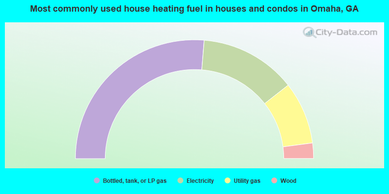
- 52.6%Bottled, tank, or LP gas
- 26.2%Electricity
- 17.0%Utility gas
- 4.2%Wood
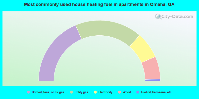
- 37.2%Bottled, tank, or LP gas
- 35.7%Utility gas
- 14.1%Electricity
- 12.1%Wood
- 1.0%Fuel oil, kerosene, etc.
Omaha compared to Georgia state average:
- Median household income below state average.
- Median house value significantly below state average.
- Black race population percentage above state average.
- Hispanic race population percentage significantly below state average.
- Foreign-born population percentage significantly below state average.
- Length of stay since moving in significantly above state average.
- Number of rooms per house significantly below state average.
- House age significantly below state average.
- Number of college students below state average.
- Percentage of population with a bachelor's degree or higher significantly below state average.