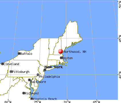
Northwood, New Hampshire
Submit your own pictures of this town and show them to the world
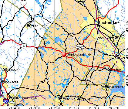
- OSM Map
- General Map
- Google Map
- MSN Map
Population change since 2000: +16.5%
 |
| Males: 2,147 | |
| Females: 2,094 |
| Median resident age: | 42.2 years |
| New Hampshire median age: | 43.9 years |
Zip codes: 03261.
| Northwood: | $93,631 |
| NH: | $89,992 |
Estimated per capita income in 2022: $47,175 (it was $21,491 in 2000)
Northwood town income, earnings, and wages data
Estimated median house or condo value in 2022: $340,698 (it was $111,500 in 2000)
| Northwood: | $340,698 |
| NH: | $384,700 |
Mean prices in 2022: all housing units: $614,227; detached houses: $665,470; townhouses or other attached units: $408,866; in 2-unit structures: $730,084; in 3-to-4-unit structures: over $1,000,000; in 5-or-more-unit structures: $329,099; mobile homes: $126,160
Detailed information about poverty and poor residents in Northwood, NH


- 4,10296.7%White alone
- 461.1%Two or more races
- 370.9%Hispanic
- 300.7%Asian alone
- 140.3%Black alone
- 110.3%American Indian alone
- 10.02%Other race alone

Races in Northwood detailed stats: ancestries, foreign born residents, place of birth
According to our research of New Hampshire and other state lists, there were 14 registered sex offenders living in Northwood, New Hampshire as of May 23, 2024.
The ratio of all residents to sex offenders in Northwood is 303 to 1.
Type |
2009 |
2010 |
2011 |
2012 |
2013 |
2014 |
2015 |
2016 |
2017 |
2018 |
2019 |
2020 |
2021 |
2022 |
|---|---|---|---|---|---|---|---|---|---|---|---|---|---|---|
| Murders (per 100,000) | 0 (0.0) | 0 (0.0) | 0 (0.0) | 0 (0.0) | 0 (0.0) | 0 (0.0) | 0 (0.0) | 0 (0.0) | 0 (0.0) | 0 (0.0) | 0 (0.0) | 0 (0.0) | 0 (0.0) | 0 (0.0) |
| Rapes (per 100,000) | 2 (47.7) | 0 (0.0) | 3 (70.6) | 2 (46.9) | 8 (186.3) | 2 (46.6) | 4 (93.0) | 2 (46.7) | 4 (93.4) | 0 (0.0) | 0 (0.0) | 2 (46.3) | 0 (0.0) | 1 (21.4) |
| Robberies (per 100,000) | 0 (0.0) | 1 (23.6) | 0 (0.0) | 0 (0.0) | 1 (23.3) | 0 (0.0) | 0 (0.0) | 1 (23.4) | 0 (0.0) | 0 (0.0) | 0 (0.0) | 0 (0.0) | 0 (0.0) | 0 (0.0) |
| Assaults (per 100,000) | 4 (95.4) | 1 (23.6) | 7 (164.8) | 8 (187.7) | 0 (0.0) | 5 (116.4) | 6 (139.5) | 5 (116.8) | 3 (70.1) | 3 (69.3) | 2 (46.5) | 1 (23.1) | 1 (22.8) | 2 (42.8) |
| Burglaries (per 100,000) | 43 (1,026) | 19 (448.0) | 19 (447.4) | 20 (469.2) | 18 (419.1) | 13 (302.7) | 16 (372.0) | 9 (210.2) | 7 (163.5) | 7 (161.8) | 3 (69.7) | 1 (23.1) | 4 (91.2) | 4 (85.7) |
| Thefts (per 100,000) | 68 (1,622) | 67 (1,580) | 84 (1,978) | 66 (1,548) | 45 (1,048) | 44 (1,024) | 46 (1,070) | 29 (677.4) | 34 (794.2) | 20 (462.3) | 25 (581.1) | 17 (393.4) | 12 (273.7) | 17 (364.0) |
| Auto thefts (per 100,000) | 1 (23.9) | 6 (141.5) | 1 (23.5) | 12 (281.5) | 0 (0.0) | 4 (93.1) | 1 (23.3) | 6 (140.2) | 3 (70.1) | 3 (69.3) | 2 (46.5) | 1 (23.1) | 2 (45.6) | 1 (21.4) |
| Arson (per 100,000) | 1 (23.9) | 0 (0.0) | 3 (70.6) | 0 (0.0) | 0 (0.0) | 2 (46.6) | 1 (23.3) | 1 (23.4) | 0 (0.0) | 1 (23.1) | 0 (0.0) | 2 (46.3) | 0 (0.0) | 0 (0.0) |
| City-Data.com crime index | 195.8 | 117.7 | 201.8 | 192.4 | 227.2 | 130.2 | 173.0 | 120.8 | 137.6 | 49.2 | 41.1 | 60.9 | 25.5 | 48.0 |
The City-Data.com crime index weighs serious crimes and violent crimes more heavily. Higher means more crime, U.S. average is 246.1. It adjusts for the number of visitors and daily workers commuting into cities.
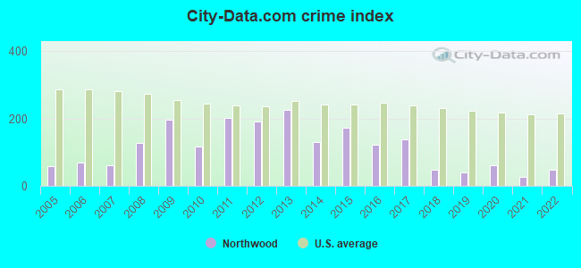
Crime rate in Northwood detailed stats: murders, rapes, robberies, assaults, burglaries, thefts, arson
Full-time law enforcement employees in 2021, including police officers: 8 (7 officers - 6 male; 1 female).
| Officers per 1,000 residents here: | 1.60 |
| New Hampshire average: | 2.14 |
 Recent articles from our blog. Our writers, many of them Ph.D. graduates or candidates, create easy-to-read articles on a wide variety of topics.

 | What are the chances NH implements an income or sales tax in the next decade? (120 replies) |
| Governor Sununu STAND YOUR GROUND! (20 replies) |
| Love everything about this state but... (130 replies) |
| Best restaurants in NH (10 replies) |
| Relocating.....Maine or New Hampshire... (20 replies) |
| The ultimate pizza joint (31 replies) |
Latest news from Northwood, NH collected exclusively by city-data.com from local newspapers, TV, and radio stations
Ancestries: English (20.9%), Irish (18.5%), French (16.0%), United States (9.4%), Italian (8.0%), Scottish (7.7%).
Current Local Time: EST time zone
Incorporated in 1773
Elevation: 559 feet
Land area: 28.0 square miles.
Population density: 152 people per square mile (very low).
53 residents are foreign born
| This town: | 1.5% |
| New Hampshire: | 4.4% |
| Northwood town: | 2.3% ($2,613) |
| New Hampshire: | 2.3% ($2,946) |
Nearest city with pop. 50,000+: Manchester, NH  (19.6 miles , pop. 107,006).
Nearest city with pop. 200,000+: Boston, MA (62.0 miles , pop. 589,141).
Nearest city with pop. 1,000,000+: Bronx, NY (213.0 miles , pop. 1,332,650).
Nearest cities:
), ), ), ), Latitude: 43.21 N, Longitude: 71.22 W
Area code: 603


Single-family new house construction building permits:
- 2022: 19 buildings, average cost: $265,600
- 2021: 9 buildings, average cost: $270,400
- 2020: 12 buildings, average cost: $229,700
- 2019: 14 buildings, average cost: $230,500
- 2018: 13 buildings, average cost: $275,700
- 2017: 2 buildings, average cost: $167,300
- 2016: 2 buildings, average cost: $167,300
- 2015: 5 buildings, average cost: $167,300
- 2014: 6 buildings, average cost: $176,700
- 2013: 5 buildings, average cost: $178,800
- 2012: 9 buildings, average cost: $109,800
- 2011: 11 buildings, average cost: $175,100
- 2010: 9 buildings, average cost: $117,600
- 2009: 20 buildings, average cost: $134,900
- 2008: 15 buildings, average cost: $157,500
- 2007: 45 buildings, average cost: $156,700
- 2006: 36 buildings, average cost: $163,400
- 2005: 36 buildings, average cost: $139,600
- 2004: 64 buildings, average cost: $113,300
- 2003: 62 buildings, average cost: $125,000
- 2002: 36 buildings, average cost: $116,100
- 2001: 21 buildings, average cost: $127,800
- 2000: 24 buildings, average cost: $96,600
- 1999: 31 buildings, average cost: $82,900
- 1998: 18 buildings, average cost: $88,000
- 1997: 16 buildings, average cost: $90,800


| Here: | 2.0% |
| New Hampshire: | 2.5% |


- Construction (9.7%)
- Health care (8.7%)
- Public administration (7.3%)
- Educational services (5.8%)
- Professional, scientific, technical services (5.1%)
- Administrative & support & waste management services (3.8%)
- Accommodation & food services (3.7%)

- Construction (16.2%)
- Administrative & support & waste management services (5.3%)
- Public administration (4.9%)
- Building material & garden equipment & supplies dealers (4.1%)
- Computer & electronic products (3.8%)
- Food & beverage stores (3.8%)
- Motor vehicle & parts dealers (3.6%)

- Health care (15.8%)
- Public administration (10.2%)
- Educational services (9.2%)
- Professional, scientific, technical services (8.3%)
- Accommodation & food services (6.0%)
- Finance & insurance (3.7%)
- Personal & laundry services (3.3%)

- Other sales and related occupations, including supervisors (4.5%)
- Other management occupations, except farmers and farm managers (3.8%)
- Laborers and material movers, hand (3.6%)
- Other production occupations, including supervisors (3.6%)
- Metal workers and plastic workers (3.2%)
- Other office and administrative support workers, including supervisors (3.1%)
- Secretaries and administrative assistants (3.1%)

- Other sales and related occupations, including supervisors (6.3%)
- Laborers and material movers, hand (5.4%)
- Metal workers and plastic workers (5.4%)
- Driver/sales workers and truck drivers (5.3%)
- Carpenters (5.0%)
- Vehicle and mobile equipment mechanics, installers, and repairers (4.9%)
- Electrical equipment mechanics and other installation, maintenance, and repair workers, including supervisors (4.1%)

- Secretaries and administrative assistants (7.0%)
- Other office and administrative support workers, including supervisors (6.2%)
- Registered nurses (4.9%)
- Bookkeeping, accounting, and auditing clerks (4.2%)
- Other management occupations, except farmers and farm managers (4.1%)
- Other production occupations, including supervisors (3.7%)
- Other healthcare support occupations (3.4%)
Average climate in Northwood, New Hampshire
Based on data reported by over 4,000 weather stations


(lower is better)

Air Quality Index (AQI) level in 2022 was 52.6. This is better than average.
| City: | 52.6 |
| U.S.: | 72.6 |

Nitrogen Dioxide (NO2) [ppb] level in 2010 was 8.02. This is significantly worse than average. Closest monitor was 13.3 miles away from the city center.
| City: | 8.02 |
| U.S.: | 5.11 |

Sulfur Dioxide (SO2) [ppb] level in 2016 was 1.05. This is significantly better than average. Closest monitor was 12.6 miles away from the city center.
| City: | 1.05 |
| U.S.: | 1.51 |

Ozone [ppb] level in 2022 was 29.4. This is about average. Closest monitor was 5.8 miles away from the city center.
| City: | 29.4 |
| U.S.: | 33.3 |

Tornado activity:
Northwood-area historical tornado activity is near New Hampshire state average. It is 50% smaller than the overall U.S. average.
On 6/9/1953, a category F3 (max. wind speeds 158-206 mph) tornado 21.0 miles away from the Northwood town center injured 5 people and caused between $5000 and $50,000 in damages.
On 7/24/2008, a category F2 (max. wind speeds 113-157 mph) tornado 6.4 miles away from the town center killed one person and injured 2 people and caused $2 million in damages.
Earthquake activity:
Northwood-area historical earthquake activity is significantly above New Hampshire state average. It is 72% smaller than the overall U.S. average.On 4/20/2002 at 10:50:47, a magnitude 5.3 (5.3 ML, Depth: 3.0 mi, Class: Moderate, Intensity: VI - VII) earthquake occurred 152.8 miles away from Northwood center
On 1/19/1982 at 00:14:42, a magnitude 4.7 (4.5 MB, 4.7 MD, 4.5 LG, Class: Light, Intensity: IV - V) earthquake occurred 27.6 miles away from the city center
On 10/7/1983 at 10:18:46, a magnitude 5.3 (5.1 MB, 5.3 LG, 5.1 ML) earthquake occurred 164.7 miles away from the city center
On 10/16/2012 at 23:12:25, a magnitude 4.7 (4.7 ML, Depth: 10.0 mi) earthquake occurred 38.8 miles away from the city center
On 4/20/2002 at 10:50:47, a magnitude 5.2 (5.2 MB, 4.2 MS, 5.2 MW, 5.0 MW) earthquake occurred 152.7 miles away from Northwood center
On 8/21/1996 at 07:54:14, a magnitude 3.8 (3.8 LG, 3.6 LG, Depth: 6.2 mi, Class: Light, Intensity: II - III) earthquake occurred 67.5 miles away from the city center
Magnitude types: regional Lg-wave magnitude (LG), body-wave magnitude (MB), duration magnitude (MD), local magnitude (ML), surface-wave magnitude (MS), moment magnitude (MW)
Natural disasters:
The number of natural disasters in Rockingham County (26) is a lot greater than the US average (15).Major Disasters (Presidential) Declared: 17
Emergencies Declared: 9
Causes of natural disasters: Storms: 12, Floods: 9, Winter Storms: 5, Hurricanes: 4, Snowstorms: 4, Snows: 2, Winds: 2, Blizzard: 1, Snowfall: 1, Tornado: 1 (Note: some incidents may be assigned to more than one category).

Hospitals and medical centers near Northwood:
- EPSOM HEALTHCARE CENTER (Nursing Home, about 9 miles away; EPSOM, NH)
- YOUR VNA (Home Health Center, about 14 miles away; ROCHESTER, NH)
- ACADEMY NH INC (Nursing Home, about 14 miles away; ROCHESTER, NH)
- FRISBIE MEMORIAL HOSPITAL Acute Care Hospitals (about 15 miles away; ROCHESTER, NH)
- RIVERSIDE REST HOME (Nursing Home, about 15 miles away; DOVER, NH)
- COLONIAL HILL OF ROCHESTER CARE AND REHABILITATION (Nursing Home, about 15 miles away; ROCHESTER, NH)
- ROCHESTER MANOR (Nursing Home, about 15 miles away; ROCHESTER, NH)
Airports and heliports located in Northwood:
- Northwood Airport (NH84) (Runways: 1)
- Skybast Heliport (98NH)
Colleges/universities with over 2000 students nearest to Northwood:
- University of New Hampshire-Main Campus (about 16 miles; Durham, NH; Full-time enrollment: 15,243)
- NHTI-Concord's Community College (about 16 miles; Concord, NH; FT enrollment: 2,865)
- Southern New Hampshire University (about 17 miles; Manchester, NH; FT enrollment: 16,552)
- Mount Washington College (about 22 miles; Manchester, NH; FT enrollment: 2,187)
- Saint Anselm College (about 22 miles; Manchester, NH; FT enrollment: 2,059)
- Northern Essex Community College (about 31 miles; Haverhill, MA; FT enrollment: 4,737)
- Merrimack College (about 38 miles; North Andover, MA; FT enrollment: 2,734)
Public high school in Northwood:
- COE-BROWN NORTHWOOD ACADEMY (Students: 717, Location: 907 FIRST NH TPKE., Grades: 9-12)
Private high school in Northwood:
- COE-BROWN NORTHWOOD ACADEMY (Students: 717, Location: 907 FIRST NH TPKE, Grades: 9-12)
Public elementary/middle school in Northwood:
- NORTHWOOD ELEMENTARY SCHOOL (Students: 453, Location: 511 FIRST NH TPKE., Grades: KG-8)
Points of interest:
Notable locations in Northwood: Camp Yavneh (A), Camp Wah-Tut-Ca (B), Northwood Fire Rescue Narrows Station (C), Northwood Fire Rescue Ridge Station (D), Chesley Memorial Library (E). Display/hide their locations on the map
Churches in Northwood include: Free Will Baptist Church (A), Edgerly Memorial Chapel (B), Saint Josephs Church (C), Northwood Congregational Church (D). Display/hide their locations on the map
Cemeteries: Fairview Cemetery (1), Bennett Cemetery (2), Bartlett Cemetery (3). Display/hide their locations on the map
Lakes and reservoirs: Harvey Lake (A), Jenness Pond (B), Northwood Lake (C), Little Acorn Pond (D), Big Acorn Pond (E), Voydatch Pond (F), Burtt Wildlife Pond (G), Tudor Wildlife Pond (H). Display/hide their locations on the map
Streams, rivers, and creeks: The Gulf (A), Sherburne Brook (B), Tucker Brook (C), Narrows Brook (D), Kelsey Brook (E), Jenness Brook (F), Flat Meadow Brook (G). Display/hide their locations on the map
Birthplace of: E. Knowlton Fogg - Politician, Bert Weeden - Baseball player.
Drinking water stations with addresses in Northwood and their reported violations in the past:
LEISURE VILLAGE (Population served: 315, Groundwater):Past health violations:LOON ESTATES (Population served: 74, Groundwater):
- MCL, Monthly (TCR) - In DEC-2013, Contaminant: Coliform. Follow-up actions: St Public Notif requested (DEC-23-2013), St Violation/Reminder Notice (DEC-23-2013), St Public Notif received (JAN-14-2014)
- MCL, Monthly (TCR) - In NOV-2013, Contaminant: Coliform. Follow-up actions: St Public Notif requested (DEC-09-2013), St Violation/Reminder Notice (DEC-09-2013), St Public Notif received (JAN-14-2014)
- MCL, Monthly (TCR) - In OCT-2013, Contaminant: Coliform. Follow-up actions: St Public Notif requested (NOV-06-2013), St Violation/Reminder Notice (NOV-06-2013), St Public Notif received (DEC-04-2013)
- MCL, Monthly (TCR) - In AUG-2013, Contaminant: Coliform. Follow-up actions: St Public Notif requested (AUG-21-2013), St Violation/Reminder Notice (AUG-21-2013), St Public Notif received (SEP-04-2013)
Past health violations:SADDLEBACK CAMPGROUND (Address: 41 CAMPGROUND RD , Population served: 50, Groundwater):Past monitoring violations:
- MCL, Monthly (TCR) - In AUG-2005, Contaminant: Coliform. Follow-up actions: St Public Notif requested (SEP-15-2005), St Violation/Reminder Notice (SEP-15-2005), St Formal NOV issued (SEP-19-2005), St Public Notif received (SEP-26-2005), St Compliance achieved (MAR-03-2006)
- 2 routine major monitoring violations
- 5 regular monitoring violations
Past monitoring violations:SUSTYS CAFE (Population served: 30, Groundwater):
- Failure To Address Deficiency - In APR-16-2013, Contaminant: GROUNDWATER RULE. Follow-up actions: St Public Notif requested (MAY-01-2013), St Violation/Reminder Notice (MAY-01-2013), St Compliance achieved (MAY-03-2013), St Public Notif received (MAY-07-2013)
Past health violations:Past monitoring violations:
- MCL, Monthly (TCR) - Between APR-2009 and JUN-2009, Contaminant: Coliform. Follow-up actions: St Violation/Reminder Notice (JUL-01-2009), St Public Notif requested (JUL-01-2009), St Public Notif received (OCT-09-2009), St Compliance achieved (JAN-08-2010)
- Monitoring, Repeat Major (TCR) - Between JAN-2007 and MAR-2007, Contaminant: Coliform (TCR). Follow-up actions: St Public Notif requested (MAR-21-2007), St Violation/Reminder Notice (MAR-21-2007), St Formal NOV issued (OCT-02-2007), St Public Notif received (FEB-19-2008), St Compliance achieved (JUL-11-2008)
- 11 routine major monitoring violations
- 5 regular monitoring violations
| This town: | 2.6 people |
| New Hampshire: | 2.5 people |
| This town: | 74.3% |
| Whole state: | 66.3% |
| This town: | 9.8% |
| Whole state: | 8.3% |
Likely homosexual households (counted as self-reported same-sex unmarried-partner households)
- Lesbian couples: 0.6% of all households
- Gay men: 0.6% of all households
| This town: | 4.2% |
| Whole state: | 6.5% |
| This town: | 1.6% |
| Whole state: | 2.8% |
Banks with branches in Northwood (2011 data):
- TD Bank, National Association: Northwood Branch at 263 1st N.H. Turnpike, branch established on 1983/09/26. Info updated 2010/10/04: Bank assets: $188,912.6 mil, Deposits: $153,149.8 mil, headquarters in Wilmington, DE, positive income, 1314 total offices, Holding Company: Toronto-Dominion Bank, The
For population 15 years and over in Northwood:

- Never married: 23.1%
- Now married: 59.6%
- Separated: 0.9%
- Widowed: 4.7%
- Divorced: 11.6%
For population 25 years and over in Northwood:
- High school or higher: 90.6%
- Bachelor's degree or higher: 23.9%
- Graduate or professional degree: 7.1%
- Unemployed: 2.1%
- Mean travel time to work (commute): 33.5 minutes


| Here: | 9.1 |
| New Hampshire average: | 10.9 |


Graphs represent county-level data. Detailed 2008 Election Results
Religion statistics for Northwood, NH (based on Rockingham County data)


| Religion | Adherents | Congregations |
|---|---|---|
| Catholic | 84,697 | 24 |
| Mainline Protestant | 19,072 | 78 |
| Evangelical Protestant | 7,456 | 61 |
| Other | 3,490 | 20 |
| Orthodox | 200 | 1 |
| None | 180,308 | - |
Food Environment Statistics:
| Rockingham County: | 1.59 / 10,000 pop. |
| New Hampshire: | 2.14 / 10,000 pop. |
| This county: | 0.17 / 10,000 pop. |
| New Hampshire: | 0.15 / 10,000 pop. |
| Here: | 1.86 / 10,000 pop. |
| State: | 1.78 / 10,000 pop. |
| This county: | 3.31 / 10,000 pop. |
| State: | 4.02 / 10,000 pop. |
| This county: | 9.56 / 10,000 pop. |
| New Hampshire: | 9.70 / 10,000 pop. |
| This county: | 7.6% |
| New Hampshire: | 7.6% |
| This county: | 23.3% |
| New Hampshire: | 24.4% |
| Rockingham County: | 16.8% |
| New Hampshire: | 15.9% |
7.69% of this county's 2021 resident taxpayers lived in other counties in 2020 ($114,534 average adjusted gross income)
| Here: | 7.69% |
| New Hampshire average: | 7.66% |
0.01% of residents moved from foreign countries ($203 average AGI)
Rockingham County: 0.01% New Hampshire average: 0.01%
Top counties from which taxpayers relocated into this county between 2020 and 2021:
| from Essex County, MA | |
| from Hillsborough County, NH | |
| from Middlesex County, MA |
6.82% of this county's 2020 resident taxpayers moved to other counties in 2021 ($88,778 average adjusted gross income)
| Here: | 6.82% |
| New Hampshire average: | 6.80% |
0.01% of residents moved to foreign countries ($126 average AGI)
Rockingham County: 0.01% New Hampshire average: 0.01%
Top counties to which taxpayers relocated from this county between 2020 and 2021:
| to Hillsborough County, NH | |
| to Strafford County, NH | |
| to Essex County, MA |
| Businesses in Northwood, NH | ||||
| Name | Count | Name | Count | |
|---|---|---|---|---|
| Circle K | 2 | True Value | 1 | |
| Dunkin Donuts | 1 | U-Haul | 1 | |
| Subway | 1 | |||
Strongest AM radio stations in Northwood:
- WGIN (930 AM; 10 kW; ROCHESTER, NH; Owner: CAPSTAR TX LIMITED PARTNERSHIP)
- WRKO (680 AM; 50 kW; BOSTON, MA; Owner: ENTERCOM BOSTON LICENSE, LLC)
- WGIR (610 AM; 5 kW; MANCHESTER, NH; Owner: CAPSTAR TX LIMITED PARTNERSHIP)
- WEEI (850 AM; 50 kW; BOSTON, MA; Owner: ENTERCOM BOSTON LICENSE, LLC)
- WDER (1320 AM; 10 kW; DERRY, NH; Owner: BLOUNT COMMUNICATIONS, INC. OF NH)
- WTSN (1270 AM; 5 kW; DOVER, NH; Owner: GARRISON CITY BROADCASTING, INC.)
- WBZ (1030 AM; 50 kW; BOSTON, MA; Owner: INFINITY BROADCASTING OPERATIONS, INC.)
- WWZN (1510 AM; 50 kW; BOSTON, MA; Owner: ROSE CITY RADIO CORPORATION)
- WCRN (830 AM; 50 kW; WORCESTER, MA; Owner: CARTER BROADCASTING CORPORATION)
- WKBR (1250 AM; 5 kW; MANCHESTER, NH; Owner: DEVON BROADCASTING COMPANY, INC.)
- WKOX (1200 AM; 50 kW; FRAMINGHAM, MA; Owner: CAPSTAR TX LIMITED PARTNERSHIP)
- WBIX (1060 AM; 40 kW; NATICK, MA; Owner: LANGER BROADCASTING CORPORATION)
- WGIP (1540 AM; 5 kW; EXETER, NH; Owner: CAPSTAR TX LIMITED PARTNERSHIP)
Strongest FM radio stations in Northwood:
- WMEX (106.5 FM; FARMINGTON, NH; Owner: WIMMEX, LLC)
- W282AF (104.3 FM; CONCORD, NH; Owner: CONCORD BIBLE FELLOWSHIP)
- WNHI (93.3 FM; BELMONT, NH; Owner: CONCORD BROADCASTING, L.L.C.)
- WOKQ (97.5 FM; DOVER, NH; Owner: CITADEL BROADCASTING COMPANY)
- WSCY (106.9 FM; MOULTONBOROUGH, NH; Owner: NORTHEAST COMMUNICATIONS CORPORATION)
- WLKZ (104.9 FM; WOLFEBORO, NH; Owner: TELE-MEDIA COMPANY OF NEW HAMPSHIRE, L.L.C.)
- WGIR-FM (101.1 FM; MANCHESTER, NH; Owner: CAPSTAR TX LIMITED PARTNERSHIP)
- WQLL (96.5 FM; BEDFORD, NH; Owner: SAGA COMMUNICATIONS OF NEW ENGLAND, LLC)
- WLMW (90.7 FM; MANCHESTER, NH; Owner: KNOWLEDGE FOR LIFE)
- WJYY (105.5 FM; CONCORD, NH; Owner: CONCORD BROADCASTING, L.L.C.)
- WZID (95.7 FM; MANCHESTER, NH; Owner: SAGA COMMUNICATIONS OF NEW ENGLAND, LLC)
- WPKQ (103.7 FM; NORTH CONWAY, NH; Owner: CITADEL BROADCASTING COMPANY)
- WHOM (94.9 FM; MT. WASHINGTON, NH; Owner: CITADEL BROADCASTING COMPANY)
- WHDQ (106.1 FM; CLAREMONT, NH; Owner: GREAT NORTHERN RADIO, L.L.C.)
- WVNH (91.1 FM; CONCORD, NH; Owner: NEW HAMPSHIRE GOSPEL RADIO, INC.)
- WMEA (90.1 FM; PORTLAND, ME; Owner: MAINE PUBLIC BROADCASTING CORPORATION)
- WVFM (105.7 FM; CAMPTON, NH; Owner: DEVON BROADCASTING COMPANY, INC.)
- WFEX (92.1 FM; PETERBOROUGH, NH; Owner: FNX BROADCASTING OF NEW HAMPSHIRE LLC)
- WQSO (96.7 FM; ROCHESTER, NH; Owner: CAPSTAR TX LIMITED PARTNERSHIP)
- WUBB (95.3 FM; YORK CENTER, ME; Owner: CAPSTAR TX LIMITED PARTNERSHIP)
TV broadcast stations around Northwood:
- WENH-TV (Channel 11; DURHAM, NH; Owner: UNIVERSITY OF NEW HAMPSHIRE)
- WPXG (Channel 21; CONCORD, NH; Owner: PAXSON BOSTON-68 LICENSE, INC.)
- WMEA-TV (Channel 26; BIDDEFORD, ME; Owner: MAINE PUBLIC BROADCASTING CORP.)
- WHDN-LP (Channel 26; BOSTON, MA; Owner: GUENTER MARKSTEINER)
- WMTW-TV (Channel 8; POLAND SPRING, ME; Owner: WMTW BROADCAST GROUP, LLC)
- WFXZ-CA (Channel 24; BOSTON, MA; Owner: BOSTON BROADCASTING CORP.)
- WCSH (Channel 6; PORTLAND, ME; Owner: PACIFIC AND SOUTHERN COMPANY, INC.)

- National Bridge Inventory (NBI) Statistics
- 1Number of bridges
- 3ft / 0.8mTotal length
- $3,142,000Total costs
- 461Total average daily traffic
- 46Total average daily truck traffic
- 682Total future (year 2042) average daily traffic
FCC Registered Cell Phone Towers:
2- 50 Old Canterbury Rd (Lat: 43.223417 Lon: -71.239778), Type: Mtower, Structure height: 37.8 m, Overall height: 38.7 m, Call Sign: KNKA226
Assigned Frequencies: 869.040 MHz, 869.040 MHz, 869.040 MHz, 824.040 MHz, 824.040 MHz, 824.040 MHz, 890.010 MHz, 890.010 MHz, 890.010 MHz, 845.010 MHz, 845.010 MHz, 845.010 MHzGrant Date: 09/09/2014, Expiration Date: 10/01/2024, Certifier: Michael P GogginRegistrant: At&t Services, Inc., 208 S Akard St, 20f, Dallas, TX 75202, Phone: (855) 699-7073, Fax: (214) 746-6410, Email:
- (Northwood) Saddleback Mountain (Lat: 43.176194 Lon: -71.206722), Type: Mast, Structure height: 31.4 m, Call Sign: KNKA201
Assigned Frequencies: 880.020 MHz, 880.020 MHz, 880.020 MHz, 835.020 MHz, 835.020 MHz, 835.020 MHz, 891.510 MHz, 891.510 MHz, 891.510 MHz, 846.510 MHz, 846.510 MHz, 846.510 MHzGrant Date: 08/26/2014, Expiration Date: 10/01/2024Registrant: Cellco Partnership, 5055 North Point Pkwy, Np2ne Network Engineering, Alpharetta, GA 30022, Phone: (770) 797-1070, Fax: (770) 797-1036, Email:
FCC Registered Broadcast Land Mobile Towers:
5- Fire Station Route Us4 (Lat: 43.207861 Lon: -71.175889), Call Sign: KIU542, Licensee ID: L00356185,
Assigned Frequencies: 154.190 MHz, 154.235 MHz, 154.355 MHz, 154.415 MHz, Grant Date: 03/11/1997, Expiration Date: 05/20/2002, Cancellation Date: 09/22/2002, Registrant: Northwood, Town Of, 499 1st Nh Tpke, Northwood, NH 03261
- 1020 First Nh Turnpike Road (Lat: 43.220222 Lon: -71.220722), Type: Pipe, Structure height: 4.5 m, Overall height: 10.6 m, Call Sign: KNCP845,
Assigned Frequencies: 154.785 MHz, Grant Date: 02/17/2022, Expiration Date: 02/15/2032, Registrant: Northwood Police Dept., 818 First Nh Turnpike, Northwood, NH 03261, Phone: (603) 583-7332, Email:
- Saddleback Mtn Wenh Tv Bldg Dirt Rd Off Rt 43 (Lat: 43.176194 Lon: -71.206167), Call Sign: KRS227,
Assigned Frequencies: 154.815 MHz, 154.815 MHz, Grant Date: 10/15/2005, Expiration Date: 11/28/2015, Cancellation Date: 12/24/2013, Registrant: Rockingham County Sheriff\'s Department, 101 North Road, Brentwood, NH 03833, Phone: (603) 679-9338, Fax: (603) 679-1877, Email:
- Northwood Ridge Fire Sta 499 First Nh Turnpike (Lat: 43.207861 Lon: -71.175889), Type: Bant, Structure height: 80 m, Overall height: 82 m, Call Sign: KNBD703,
Assigned Frequencies: 155.340 MHz, Grant Date: 06/28/2011, Expiration Date: 08/04/2021, Cancellation Date: 10/09/2021, Registrant: Northwood Fire/Rescue, 499 First Nh Turnpike, Northwood, NH 03261, Phone: (603) 942-9103, Fax: (603) 942-9104, Email:
- Rt 4 (Lat: 43.216750 Lon: -71.207278), Type: Building, Structure height: 8 m, Call Sign: WPFY394,
Assigned Frequencies: 151.865 MHz, Grant Date: 10/18/1999, Expiration Date: 11/22/2004, Cancellation Date: 01/22/2005, Registrant: Coe Brown Northwood Academy, Rt 4, Northwood, NH 03261, Phone: (603) 942-5531
FCC Registered Microwave Towers:
9 (See the full list of FCC Registered Microwave Towers in this town)FCC Registered Amateur Radio Licenses:
40 (See the full list of FCC Registered Amateur Radio Licenses in Northwood)FAA Registered Aircraft:
7- Aircraft: JABIRU USA SPORT AIRCRAFT LLC J170-SP (Category: Land, Seats: 2, Weight: Up to 12,499 Pounds), Engine: AMA/EXPR UNKNOWN ENG (4 Cycle)
N-Number: 11216, N11216, N-11216, Serial Number: 37, Year manufactured: 2005, Airworthiness Date: 11/11/2005, Certificate Issue Date: 11/20/2017
Registrant (Individual): Pelt Scott Van, 312 Ye Olde Canterbury Rd, Northwood, NH 03261 - Aircraft: CESSNA 120 (Category: Land, Seats: 2, Weight: Up to 12,499 Pounds, Speed: 90 mph), Engine: CONT MOTOR C85 SERIES (85 HP) (Reciprocating)
N-Number: 1935N, N1935N, N-1935N, Serial Number: 12175, Year manufactured: 1947, Airworthiness Date: 03/29/1956, Certificate Issue Date: 05/14/2014
Registrant (Individual): Alice M Gilchrist, 96 Lucas Pond Rd, Northwood, NH 03261 - Aircraft: BEAUVAIS WILLIAM G BOWERS FLY BABY 1A (Category: Land, Weight: Up to 12,499 Pounds), Engine: Reciprocating
N-Number: 2505B, N2505B, N-2505B, Serial Number: 5464, Certificate Issue Date: 02/06/2020
Registrant (Individual): William G Beauvais, 348 Ridge Rd, Northwood, NH 03261 - Aircraft: CESSNA 340A (Category: Land, Engines: 2, Seats: 6, Weight: Up to 12,499 Pounds, Speed: 90 mph), Engine: CONT MOTOR TSIO-520 SER (300 HP) (Reciprocating)
N-Number: 340EE, N340EE, N-340EE, Serial Number: 340A1225, Year manufactured: 1981, Airworthiness Date: 05/13/1981, Certificate Issue Date: 09/20/2012
Registrant (Individual): Mark R Foley, 404 Bow Lake Rd, Northwood, NH 03261 - Aircraft: EDMUNDS BOWERS FLY BABY 1A (Category: Land, Weight: Up to 12,499 Pounds, Speed: 85 mph), Engine: CONT MOTOR A&C65 SERIES (65 HP) (Reciprocating)
N-Number: 571, N571, N-571, Serial Number: 7137, Year manufactured: 1971, Airworthiness Date: 06/20/1980, Certificate Issue Date: 08/11/2014
Registrant (Individual): William G Beauvais, 348 Ridge Rd, Northwood, NH 03261 - Aircraft: ROBINSON HELICOPTER R22 BETA (Category: Land, Seats: 2, Weight: Up to 12,499 Pounds), Engine: LYCOMING 0-360-A1D (180 HP) (Reciprocating)
N-Number: 8341N, N8341N, N-8341N, Serial Number: 2656, Airworthiness Date: 01/08/1997, Certificate Issue Date: 03/21/2019
Registrant (LLC): Cerebral Development LLC, 36 Bean Rd, Northwood, NH 03261 - Aircraft: BOEING A75N1 (Category: Land, Seats: 2, Weight: Up to 12,499 Pounds), Engine: Reciprocating
N-Number: 670CT, N670CT, N-670CT, Serial Number: 75-5414, Certificate Issue Date: 08/27/2001
Registrant (Individual): Charles W Iii Therriauit, 266 Harmony Rd, Northwood, NH 03261
Deregistered: Cancel Date: 06/21/2017
2002 - 2018 National Fire Incident Reporting System (NFIRS) incidents
- Fire incident types reported to NFIRS in Northwood, NH
- 29258.9%Structure Fires
- 12224.6%Outside Fires
- 6112.3%Mobile Property/Vehicle Fires
- 214.2%Other
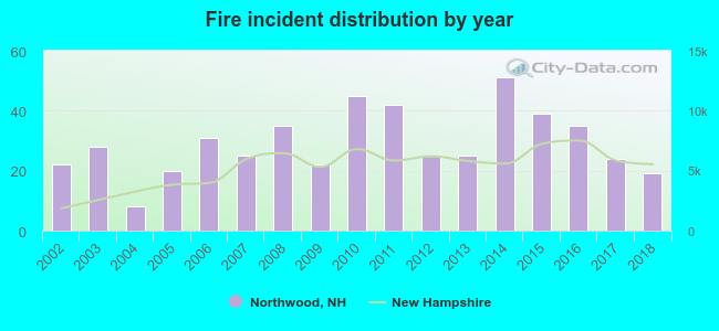 According to the data from the years 2002 - 2018 the average number of fires per year is 29. The highest number of fire incidents - 51 took place in 2014, and the least - 8 in 2004. The data has a dropping trend.
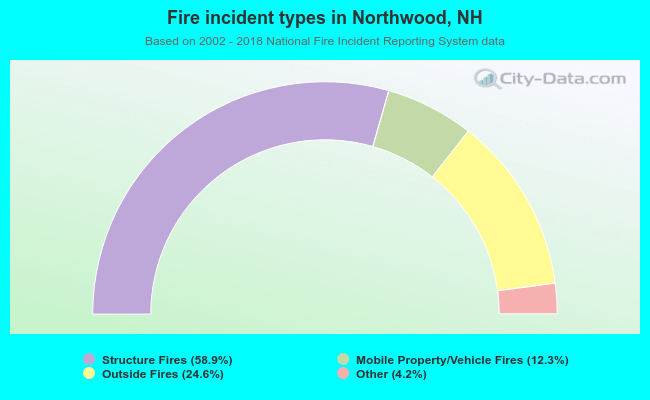 When looking into fire subcategories, the most incidents belonged to: Structure Fires (58.9%), and Outside Fires (24.6%).
Fire-safe hotels and motels in Northwood, New Hampshire:
- Lake Shore Farm, 275 Jenness Pond Rd, Northwood, New Hampshire 03261 , Phone: (603) 942-5521
- Northwood Motel, 1130 1st NH Tpke, Northwood, New Hampshire 03261 , Phone: (603) 942-5476, Fax: (603) 942-5476

- 72.0%Fuel oil, kerosene, etc.
- 19.3%Bottled, tank, or LP gas
- 6.4%Wood
- 1.3%Electricity
- 1.0%Utility gas

- 48.1%Fuel oil, kerosene, etc.
- 34.5%Bottled, tank, or LP gas
- 10.2%Electricity
- 2.4%Utility gas
- 2.4%Wood
- 2.4%No fuel used
Northwood compared to New Hampshire state average:
- Unemployed percentage significantly below state average.
- Black race population percentage significantly below state average.
- Hispanic race population percentage significantly below state average.
- Foreign-born population percentage significantly below state average.
- Renting percentage below state average.
- Length of stay since moving in significantly above state average.
- Number of rooms per house significantly below state average.
- House age significantly below state average.

|
|
Total of 24 patent applications in 2008-2024.