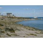
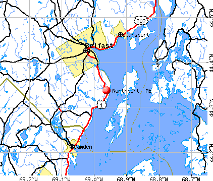
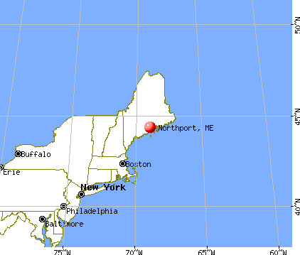
Northport, Maine

Submit your own pictures of this town and show them to the world
- OSM Map
- General Map
- Google Map
- MSN Map
Population change since 2000: +14.2%
 |
| Males: 740 | |
| Females: 780 |
| Median resident age: | 47.8 years |
| Maine median age: | 43.0 years |
Zip codes: 04849.
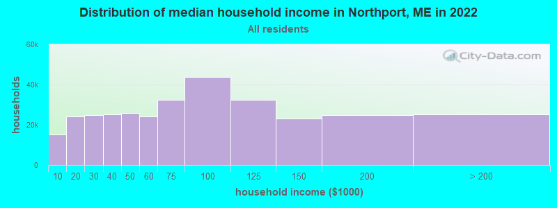
| Northport: | $74,123 |
| ME: | $69,543 |
Estimated per capita income in 2022: $45,484 (it was $21,438 in 2000)
Northport town income, earnings, and wages data
Estimated median house or condo value in 2022: $315,130 (it was $107,900 in 2000)
| Northport: | $315,130 |
| ME: | $290,600 |
Mean prices in 2022: all housing units: $270,070; detached houses: $293,055; townhouses or other attached units: $325,130; in 2-unit structures: $297,158; in 3-to-4-unit structures: $211,194; in 5-or-more-unit structures: $284,526; mobile homes: $128,233; occupied boats, rvs, vans, etc.: $21,180
Detailed information about poverty and poor residents in Northport, ME


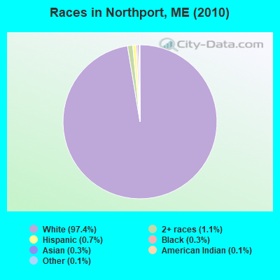
- 1,48197.4%White alone
- 161.1%Two or more races
- 110.7%Hispanic
- 40.3%Black alone
- 40.3%Asian alone
- 20.1%American Indian alone
- 20.1%Other race alone
Races in Northport detailed stats: ancestries, foreign born residents, place of birth
According to our research of Maine and other state lists, there were 5 registered sex offenders living in Northport, Maine as of May 26, 2024.
The ratio of all residents to sex offenders in Northport is 304 to 1.
 Recent articles from our blog. Our writers, many of them Ph.D. graduates or candidates, create easy-to-read articles on a wide variety of topics.

 | Looking for info on 179 Northport Avenue in Belfast, Maine (6 replies) |
| Weighing risks of giving up current situation and moving to Maine (41 replies) |
| Well, here goes. The start to our trek North to Maine, our new home-state. (395 replies) |
| Can I afford to live in Maine? (34 replies) |
| Relocating to Maine to teach at Unity (12 replies) |
| Desire to Move and Retire in Maine (23 replies) |
Latest news from Northport, ME collected exclusively by city-data.com from local newspapers, TV, and radio stations
Northport, ME City Guides:
Ancestries: English (24.4%), Irish (21.3%), French (8.8%), German (7.5%), United States (7.4%), Scottish (4.0%).
Current Local Time: EST time zone
Incorporated on 02/13/1796
Elevation: 171 feet
Land area: 23.7 square miles.
Population density: 64 people per square mile (very low).
51 residents are foreign born (1.4% Europe, 1.4% North America, 0.7% Asia).
| This town: | 3.8% |
| Maine: | 2.9% |
| Northport town: | 1.1% ($1,223) |
| Maine: | 1.5% ($1,417) |
Nearest city with pop. 50,000+: Portland, ME  (79.2 miles , pop. 64,249).
Nearest city with pop. 200,000+: Boston, MA (175.3 miles , pop. 589,141).
Nearest city with pop. 1,000,000+: Bronx, NY (346.8 miles , pop. 1,332,650).
Nearest cities:
), ), ), Latitude: 44.34 N, Longitude: 68.99 W
Area code commonly used in this area: 207

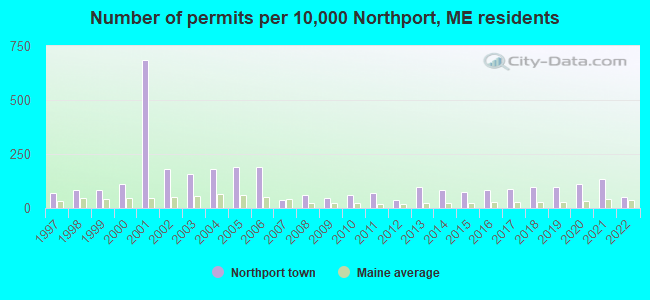
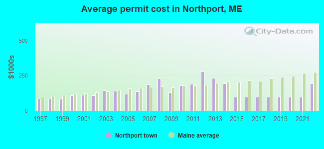
Single-family new house construction building permits:
- 2022: 7 buildings, average cost: $195,700
- 2021: 18 buildings, average cost: $99,500
- 2020: 15 buildings, average cost: $99,500
- 2019: 13 buildings, average cost: $99,500
- 2018: 13 buildings, average cost: $99,500
- 2017: 12 buildings, average cost: $99,500
- 2016: 11 buildings, average cost: $99,500
- 2015: 10 buildings, average cost: $99,500
- 2014: 11 buildings, average cost: $195,900
- 2013: 13 buildings, average cost: $231,600
- 2012: 5 buildings, average cost: $278,000
- 2011: 9 buildings, average cost: $189,800
- 2010: 8 buildings, average cost: $181,000
- 2009: 6 buildings, average cost: $132,300
- 2008: 8 buildings, average cost: $227,800
- 2007: 5 buildings, average cost: $186,600
- 2006: 25 buildings, average cost: $136,800
- 2005: 25 buildings, average cost: $120,400
- 2004: 24 buildings, average cost: $140,900
- 2003: 21 buildings, average cost: $146,400
- 2002: 24 buildings, average cost: $108,600
- 2001: 91 buildings, average cost: $111,900
- 2000: 15 buildings, average cost: $111,000
- 1999: 11 buildings, average cost: $84,700
- 1998: 11 buildings, average cost: $84,700
- 1997: 9 buildings, average cost: $84,700
| Here: | 2.6% |
| Maine: | 3.4% |

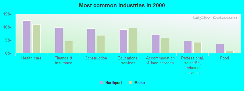
- Health care (12.6%)
- Finance & insurance (9.9%)
- Construction (9.4%)
- Educational services (9.1%)
- Accommodation & food services (7.2%)
- Professional, scientific, technical services (4.8%)
- Food (3.7%)

- Construction (17.3%)
- Professional, scientific, technical services (7.7%)
- Finance & insurance (6.2%)
- Educational services (5.6%)
- Motor vehicle & parts dealers (4.3%)
- Health care (4.3%)
- Building material & garden equipment & supplies dealers (4.0%)

- Health care (21.3%)
- Finance & insurance (13.8%)
- Educational services (12.8%)
- Accommodation & food services (10.8%)
- Food (3.6%)
- Building material & garden equipment & supplies dealers (3.3%)
- Public administration (3.0%)

- Other management occupations, except farmers and farm managers (8.6%)
- Other sales and related occupations, including supervisors (5.1%)
- Registered nurses (5.1%)
- Other production occupations, including supervisors (4.8%)
- Preschool, kindergarten, elementary, and middle school teachers (4.0%)
- Building and grounds cleaning and maintenance occupations (3.8%)
- Carpenters (3.2%)
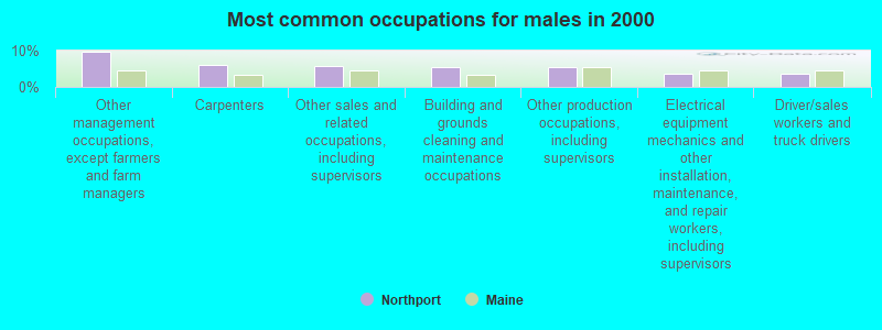
- Other management occupations, except farmers and farm managers (9.6%)
- Carpenters (6.2%)
- Other sales and related occupations, including supervisors (5.9%)
- Building and grounds cleaning and maintenance occupations (5.6%)
- Other production occupations, including supervisors (5.6%)
- Electrical equipment mechanics and other installation, maintenance, and repair workers, including supervisors (3.7%)
- Driver/sales workers and truck drivers (3.7%)

- Registered nurses (9.8%)
- Preschool, kindergarten, elementary, and middle school teachers (7.5%)
- Other management occupations, except farmers and farm managers (7.5%)
- Customer service representatives (4.6%)
- Other sales and related occupations, including supervisors (4.3%)
- Secretaries and administrative assistants (3.9%)
- Information and record clerks, except customer service representatives (3.9%)
Average climate in Northport, Maine
Based on data reported by over 4,000 weather stations


Earthquake activity:
Northport-area historical earthquake activity is significantly above Maine state average. It is 79% smaller than the overall U.S. average.On 10/16/2012 at 23:12:25, a magnitude 4.7 (4.7 ML, Depth: 10.0 mi, Class: Light, Intensity: IV - V) earthquake occurred 97.8 miles away from Northport center
On 4/20/2002 at 10:50:47, a magnitude 5.3 (5.3 ML, Depth: 3.0 mi, Class: Moderate, Intensity: VI - VII) earthquake occurred 232.9 miles away from Northport center
On 4/20/2002 at 10:50:47, a magnitude 5.2 (5.2 MB, 4.2 MS, 5.2 MW, 5.0 MW) earthquake occurred 233.9 miles away from Northport center
On 1/19/1982 at 00:14:42, a magnitude 4.7 (4.5 MB, 4.7 MD, 4.5 LG) earthquake occurred 142.6 miles away from the city center
On 10/7/1983 at 10:18:46, a magnitude 5.3 (5.1 MB, 5.3 LG, 5.1 ML) earthquake occurred 267.0 miles away from Northport center
On 2/26/1999 at 03:38:43, a magnitude 3.8 (3.8 LG, Depth: 2.0 mi, Class: Light, Intensity: II - III) earthquake occurred 27.9 miles away from Northport center
Magnitude types: regional Lg-wave magnitude (LG), body-wave magnitude (MB), duration magnitude (MD), local magnitude (ML), surface-wave magnitude (MS), moment magnitude (MW)
Natural disasters:
The number of natural disasters in Waldo County (19) is greater than the US average (15).Major Disasters (Presidential) Declared: 15
Emergencies Declared: 3
Causes of natural disasters: Floods: 14, Storms: 11, Snows: 3, Heavy Rains: 2, Winter Storms: 2, Blizzard: 1, Hurricane: 1, Ice Storm: 1, Landslide: 1, Snowfall: 1, Wind: 1, Other: 1 (Note: some incidents may be assigned to more than one category).
Hospitals and medical centers near Northport:
- WALDO COUNTY GENERAL HOSPITAL Critical Access Hospitals (about 5 miles away; BELFAST, ME)
- DIALYSIS CLINIC INC. - BELFAST (Dialysis Facility, about 5 miles away; BELFAST, ME)
- THE COMMONS AT TALL PINES (Nursing Home, about 5 miles away; BELFAST, ME)
- BRADBURY MANOR (Nursing Home, about 6 miles away; BELFAST, ME)
- HARBOR HILL CENTER (Nursing Home, about 7 miles away; BELFAST, ME)
- WINDWARD GARDENS (Nursing Home, about 11 miles away; CAMDEN, ME)
- CAMDEN COMM HOSP HC CENTR (Nursing Home, about 11 miles away; CAMDEN, ME)
Colleges/universities with over 2000 students nearest to Northport:
- Husson University (about 35 miles; Bangor, ME; Full-time enrollment: 2,421)
- University of Maine at Augusta (about 40 miles; Augusta, ME; FT enrollment: 3,204)
- University of Maine (about 42 miles; Orono, ME; FT enrollment: 8,931)
- University of Maine at Farmington (about 62 miles; Farmington, ME; FT enrollment: 2,036)
- Southern Maine Community College (about 79 miles; South Portland, ME; FT enrollment: 4,666)
- University of Southern Maine (about 80 miles; Portland, ME; FT enrollment: 6,647)
- Saint Joseph's College of Maine (about 83 miles; Standish, ME; FT enrollment: 2,010)
Public elementary/middle school in Northport:
- EDNA DRINKWATER SCHOOL (Students: 96, Location: 56 BAYSIDE ROAD, Grades: PK-4)
Points of interest:
Notable locations in Northport: Northport Volunteer Fire Department Bluff Station (A), Northport Volunteer Fire Department (B), Northport First Responders (C). Display/hide their locations on the map
Cemeteries: Saturday Cove Cemetery (1), Pitcher Cemetery (2), Knight Cemetery (3), East Northport Cemetery (4), Collier Cemetery (5). Display/hide their locations on the map
Lakes, reservoirs, and swamps: Knight Pond (A), Belfast Reservoir Number One (B), Herricks Bog (C). Display/hide their locations on the map
Streams, rivers, and creeks: Sucker Brook (A), Shaw Brook (B), Crockett Branch (C), Little River (D). Display/hide their locations on the map
Beaches: Pebble Beach (A), Cals Beach (B), Wales Beach (C). Display/hide their locations on the map
Hotel: Northport Motel & Cottages (561 Atlantic Highway) (1). Display/hide its approximate location on the map
Drinking water stations with addresses in Northport and their reported violations in the past:
HIDEAWAY DINER (Population served: 250, Groundwater):Past monitoring violations:NORTHPORT TRAVEL PARK (Population served: 180, Groundwater):
- 4 routine major monitoring violations
Past monitoring violations:POINT LOOKOUT - THE ROC (Population served: 60, Groundwater):
- One routine major monitoring violation
Past health violations:POINT LOOKOUT - GINLEY HALL (Population served: 60, Groundwater):Past monitoring violations:
- MCL, Monthly (TCR) - Between OCT-2008 and DEC-2008, Contaminant: Coliform. Follow-up actions: St Public Notif requested (OCT-21-2008), St Formal NOV issued (OCT-21-2008), St Public Notif received (OCT-30-2008), St Compliance achieved (OCT-31-2008)
- 2 routine major monitoring violations
Past health violations:POINT LOOKOUT - FITNESS CENTER (Population served: 30, Groundwater):Past monitoring violations:
- MCL, Monthly (TCR) - In NOV-2013, Contaminant: Coliform. Follow-up actions: St Compliance achieved (DEC-11-2013), St Public Notif requested (DEC-16-2013), St Formal NOV issued (DEC-16-2013), St Public Notif received (JAN-08-2014)
- MCL, Monthly (TCR) - In SEP-2013, Contaminant: Coliform. Follow-up actions: St Public Notif requested (SEP-18-2013), St Formal NOV issued (SEP-18-2013), St Compliance achieved (OCT-03-2013), St Public Notif received (OCT-08-2013)
- MCL, Monthly (TCR) - In JUN-2013, Contaminant: Coliform. Follow-up actions: St Public Notif requested (JUN-20-2013), St Formal NOV issued (JUN-20-2013), St Public Notif received (JUL-01-2013), St Compliance achieved (AUG-20-2013)
- Monitoring, Repeat Major (TCR) - In NOV-2013, Contaminant: Coliform (TCR). Follow-up actions: St Compliance achieved (DEC-11-2013), St Public Notif requested (DEC-16-2013), St Formal NOV issued (DEC-16-2013), St Public Notif received (JAN-08-2014)
- Monitoring, Source Water (GWR) - In SEP-2013, Contaminant: E. COLI. Follow-up actions: St Public Notif requested (OCT-29-2013), St Formal NOV issued (OCT-29-2013), St Public Notif received (JUN-24-2014), St Site Visit (enforcement) (JUN-24-2014)
- One routine major monitoring violation
- 2 minor monitoring violations
Past monitoring violations:
- One routine major monitoring violation
| This town: | 2.2 people |
| Maine: | 2.3 people |
| This town: | 63.0% |
| Whole state: | 62.9% |
| This town: | 9.7% |
| Whole state: | 9.4% |
Likely homosexual households (counted as self-reported same-sex unmarried-partner households)
- Lesbian couples: 0.7% of all households
- Gay men: 0.4% of all households
| This town: | 11.5% |
| Whole state: | 10.9% |
| This town: | 4.1% |
| Whole state: | 4.1% |
For population 15 years and over in Northport:

- Never married: 17.9%
- Now married: 62.8%
- Separated: 0.9%
- Widowed: 6.7%
- Divorced: 11.7%
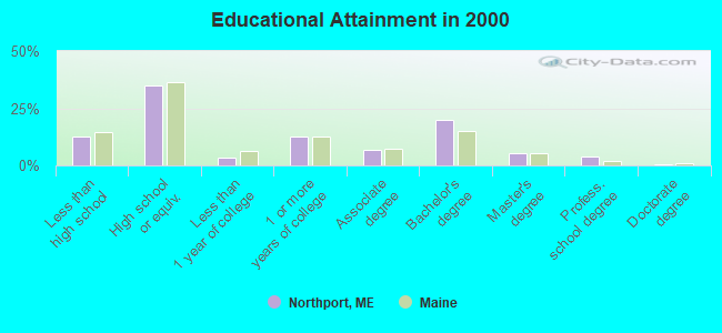
For population 25 years and over in Northport:
- High school or higher: 87.3%
- Bachelor's degree or higher: 29.7%
- Graduate or professional degree: 9.8%
- Unemployed: 4.1%
- Mean travel time to work (commute): 19.4 minutes

| Here: | 11.1 |
| Maine average: | 11.2 |
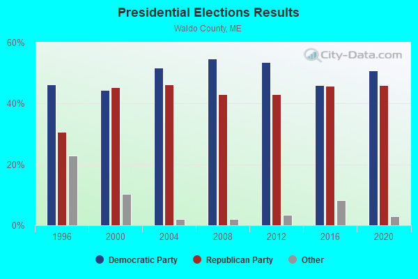
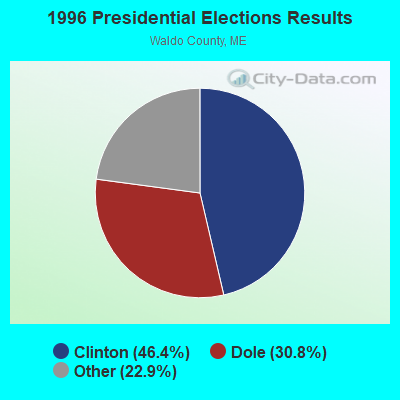
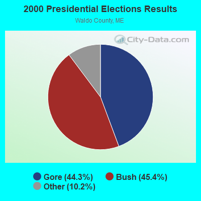
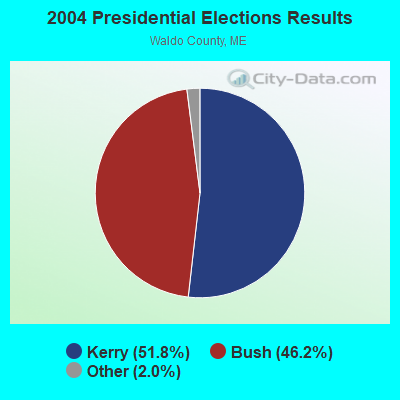


Graphs represent county-level data. Detailed 2008 Election Results
Religion statistics for Northport, ME (based on Waldo County data)
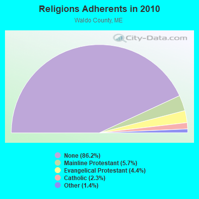
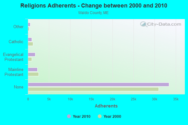
| Religion | Adherents | Congregations |
|---|---|---|
| Mainline Protestant | 2,204 | 20 |
| Evangelical Protestant | 1,711 | 23 |
| Catholic | 900 | 3 |
| Other | 554 | 7 |
| None | 33,417 | - |
Food Environment Statistics:
| Waldo County: | 2.60 / 10,000 pop. |
| State: | 2.80 / 10,000 pop. |
| This county: | 1.82 / 10,000 pop. |
| State: | 2.20 / 10,000 pop. |
| Waldo County: | 7.02 / 10,000 pop. |
| State: | 5.75 / 10,000 pop. |
| This county: | 8.84 / 10,000 pop. |
| State: | 11.02 / 10,000 pop. |
| Waldo County: | 9.2% |
| State: | 8.2% |
| Waldo County: | 26.1% |
| State: | 25.0% |
Businesses in Northport, ME
- MasterBrand Cabinets: 1
Strongest AM radio stations in Northport:
- WZON (620 AM; 5 kW; BANGOR, ME; Owner: THE ZONE CORPORATION)
- WABI (910 AM; 5 kW; BANGOR, ME; Owner: CLEAR CHANNEL BROADCASTING LICENSES, INC.)
- WDEA (1370 AM; 5 kW; ELLSWORTH, ME; Owner: CUMULUS LICENSING CORP.)
- WSKW (1160 AM; 10 kW; SKOWHEGAN, ME; Owner: MOUNTAIN WIRELESS, INCORPORATED)
- WRKD (1450 AM; 1 kW; ROCKLAND, ME; Owner: CLEAR CHANNEL BROADCASTING LICENSES, INC.)
- WRKO (680 AM; 50 kW; BOSTON, MA; Owner: ENTERCOM BOSTON LICENSE, LLC)
- WFAU (1280 AM; 5 kW; GARDINER, ME; Owner: CAPSTAR TX LIMITED PARTNERSHIP)
- WTME (780 AM; 10 kW; RUMFORD, ME; Owner: MOUNTAIN VALLEY BROADCASTING, INC.)
- WEEI (850 AM; 50 kW; BOSTON, MA; Owner: ENTERCOM BOSTON LICENSE, LLC)
- WBZ (1030 AM; 50 kW; BOSTON, MA; Owner: INFINITY BROADCASTING OPERATIONS, INC.)
- WMTW (870 AM; 10 kW; GORHAM, ME; Owner: RADIO PARTNERS OF MAINE, L.P.)
- WCRN (830 AM; 50 kW; WORCESTER, MA; Owner: CARTER BROADCASTING CORPORATION)
- WGAN (560 AM; 5 kW; PORTLAND, ME; Owner: SAGA COMMUNICATIONS OF NEW ENGLAND, LLC)
Strongest FM radio stations in Northport:
- WBYA (105.5 FM; ISLESBORO, ME; Owner: MARINER BROADCASTING LIMTED PARTNERSHIP)
- WFZX (101.7 FM; SEARSPORT, ME; Owner: CLEAR CHANNEL BROADCASTING LICENSES, INC.)
- WMEP (90.5 FM; CAMDEN, ME; Owner: MAINE PUBLIC BROADCASTING CORP.)
- WQSS (102.5 FM; CAMDEN, ME; Owner: CLEAR CHANNEL BROADCASTING LICENSES, INC.)
- WBFB (104.7 FM; BELFAST, ME; Owner: CLEAR CHANNEL BROADCASTING LICENSES, INC.)
- WMCM (103.3 FM; ROCKLAND, ME; Owner: CLEAR CHANNEL BROADCASTING LICENSES, INC.)
- WWBX (97.1 FM; BANGOR, ME; Owner: CLEAR CHANNEL BROADCASTING LICENSES, INC.)
- WERU-FM (89.9 FM; BLUE HILL, ME; Owner: SALT POND COMMUNITY B/C COMPANY)
- WBQX (106.9 FM; THOMASTON, ME; Owner: MARINER BROADCASTING LIMITED PARTNER)
- WWMJ (95.7 FM; ELLSWORTH, ME; Owner: CUMULUS LICENSING CORP.)
- WKIT-FM (100.3 FM; BREWER, ME; Owner: THE ZONE CORPORATION)
- WMEH (90.9 FM; BANGOR, ME; Owner: MAINE PUBLIC BROADCASTING CORPORATION)
- WEZQ (92.9 FM; BANGOR, ME; Owner: CUMULUS LICENSING CORP.)
- WWWA (95.3 FM; WINSLOW, ME; Owner: LIGHT OF LIFE MINISTRIES, INC.)
TV broadcast stations around Northport:
- WABI-TV (Channel 5; BANGOR, ME; Owner: COMMUNITY BROADCASTING SERVICE)
- W36CK (Channel 36; BANGOR, ME; Owner: TRINITY BROADCASTING NETWORK)
- W64BY (Channel 64; ROCKLAND, ME; Owner: CRAIG MINISTRIES, INC.)
- Northport, Maine
- Fatal accident count9
- Vehicles involved in fatal accidents14
- Fatal accidents involving drunk persons:3
- Fatalities10
- Persons involved in fatal accidents27
- Pedestrians involved in fatal accidents0
- Maine average
- Fatal accident count1243
- Vehicles involved in fatal accidents1817
- Fatal accidents involving drunk persons375
- Fatalities1359
- Persons involved in fatal accidents2847
- Pedestrians involved in fatal accidents140
- National Bridge Inventory (NBI) Statistics
- 2Number of bridges
- 7ft / 2.4mTotal length
- 7,949Total average daily traffic
- 397Total average daily truck traffic
- 11,166Total future (year 2036) average daily traffic
FCC Registered Cell Phone Towers:
3 (See the full list of FCC Registered Cell Phone Towers in Northport)FCC Registered Antenna Towers:
40 (See the full list of FCC Registered Antenna Towers)FCC Registered Broadcast Land Mobile Towers:
1- 67 Atlantic Highway (Lat: 44.624167 Lon: -68.953889), Type: Bant, Structure height: 6.1 m, Overall height: 8.2 m, Call Sign: WQCS201,
Assigned Frequencies: 159.465 MHz, Grant Date: 04/07/2015, Expiration Date: 05/12/2025, Certifier: Owen R Smith, Registrant: Waldo County Emergency Management Agency, 4 Public Safety Way, Belfast, ME 04915, Phone: (207) 338-3870, Fax: (207) 338-1890, Email:
FCC Registered Microwave Towers:
7- NORTHPORT, 300' North Of Route 1 Lincoln Beach (Lat: 44.311194 Lon: -68.973083), Type: Gtower, Structure height: 57.6 m, Overall height: 60.7 m, Call Sign: WMR308,
Assigned Frequencies: 6765.00 MHz, 6755.00 MHz, 6805.00 MHz, Grant Date: 03/01/2011, Expiration Date: 02/01/2021, Cancellation Date: 03/26/2019, Registrant: Holland & Knight LLP, 800 17th Street, N.W., Suite 1100, Washington, DC 20006-3906, Phone: (202) 955-3000, Fax: (202) 955-5564, Email:
- NORTHPORT, 67 Atlantic Hwy (Lat: 44.624167 Lon: -68.953889), Type: Bant, Structure height: 6.1 m, Overall height: 8.2 m, Call Sign: WQKW533,
Assigned Frequencies: 942.575 MHz, 942.575 MHz, Grant Date: 10/03/2019, Expiration Date: 10/06/2029, Certifier: Owen R Smith, Registrant: Waldo County Emergency Management Agency, 4 Public Safety Way, Belfast, ME 04915, Phone: (207) 338-3870, Fax: (207) 338-1890, Email:
- NORTHPORT WEST, 108 Ryan Road (Lat: 44.363556 Lon: -69.056528), Type: Tower, Structure height: 59.4 m, Overall height: 60.6 m, Call Sign: WQLC616,
Assigned Frequencies: 10795.0 MHz, Grant Date: 12/03/2009, Expiration Date: 12/03/2019, Cancellation Date: 02/25/2014, Certifier: Pamelia Y Hoof, Registrant: Verizon Wireless, 1120 Sanctuary Pkwy, #150 Gasa5reg, Alpharetta, GA 30009-7630, Phone: (770) 797-1070, Fax: (770) 797-1036, Email:
- Northport West, 108 Ryan Road (Lat: 44.363556 Lon: -69.056556), Type: Ltower, Structure height: 58.2 m, Overall height: 59.4 m, Call Sign: WQSJ421,
Assigned Frequencies: 19525.0 MHz, 19525.0 MHz, 19525.0 MHz, 19525.0 MHz, 19525.0 MHz, 19525.0 MHz, 19525.0 MHz, 19525.0 MHz, 19525.0 MHz, Grant Date: 09/26/2013, Expiration Date: 09/26/2023, Cancellation Date: 10/21/2020, Certifier: Jessica B Lyons, Registrant: At&t Services, Inc., 208 S Akard St, Rm 2100, Dallas, TX 75202, Phone: (855) 699-7073, Fax: (214) 746-6410, Email:
- Northport, 361 Atlantic Highway (Lat: 44.316028 Lon: -68.970250), Type: Gtower, Structure height: 91.4 m, Overall height: 92.4 m, Call Sign: WQSR901,
Assigned Frequencies: 17965.0 MHz, 17965.0 MHz, 17965.0 MHz, 17965.0 MHz, 17965.0 MHz, 17965.0 MHz, 17965.0 MHz, 17965.0 MHz, 17965.0 MHz, Grant Date: 11/05/2013, Expiration Date: 11/05/2023, Cancellation Date: 07/24/2020, Certifier: Jessica B Lyons, Registrant: At&t Services, Inc., 208 S. Akard Street, Room 2100, Dallas, TX 75202, Phone: (855) 699-7073, Email:
- East Northport, 7 Pound Hill Road (Lat: 44.356889 Lon: -68.967750), Type: Ltower, Structure height: 49.4 m, Call Sign: WQTI739,
Assigned Frequencies: 10815.0 MHz, 10815.0 MHz, 10815.0 MHz, 10815.0 MHz, 10815.0 MHz, 10815.0 MHz, 10815.0 MHz, 10815.0 MHz, 10815.0 MHz, 19525.0 MHz... (+8 more), Grant Date: 02/11/2014, Expiration Date: 02/11/2024, Cancellation Date: 07/24/2020, Certifier: Jessica B Lyons, Registrant: At&t Services, Inc., 208 S. Akard Street, Room 2100, Dallas, TX 75202, Phone: (855) 699-7073, Email:
- POINTE LOOKO, Off Atlantic Hwy - Mbna (Lat: 44.310889 Lon: -69.001778), Type: Bant, Structure height: 14.8 m, Overall height: 16.2 m, Call Sign: WRVS885,
Assigned Frequencies: 6595.00 MHz, 6595.00 MHz, 6595.00 MHz, 6595.00 MHz, 6595.00 MHz, 6595.00 MHz, 6595.00 MHz, 6595.00 MHz, Grant Date: 01/03/2023, Expiration Date: 01/03/2033, Certifier: Michael Larrivee, Registrant: Radio Communications Management Inc., 158 Rand Road, Rcm, Portland, ME 04102, Phone: (207) 797-7503, Email:
FCC Registered Amateur Radio Licenses:
9 (See the full list of FCC Registered Amateur Radio Licenses in Northport)FAA Registered Aircraft:
1- Aircraft: CESSNA T206H (Category: Land, Seats: 6, Weight: Up to 12,499 Pounds), Engine: LYCOMING TIO-540-AJ1A (310 HP) (Reciprocating)
N-Number: 161CS, N161CS, N-161CS, Serial Number: T20609101, Year manufactured: 2013, Airworthiness Date: 08/15/2013, Certificate Issue Date: 06/10/2016
Registrant (LLC): Alberco LLC, 16 Highfields Ln, Northport, ME 04849
2004 - 2018 National Fire Incident Reporting System (NFIRS) incidents
- Fire incident types reported to NFIRS in Northport, ME
- 10563.3%Structure Fires
- 4225.3%Outside Fires
- 1911.4%Mobile Property/Vehicle Fires
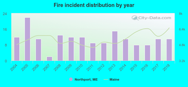 According to the data from the years 2004 - 2018 the average number of fire incidents per year is 11. The highest number of reported fires - 22 took place in 2005, and the least - 2 in 2007. The data has a decreasing trend.
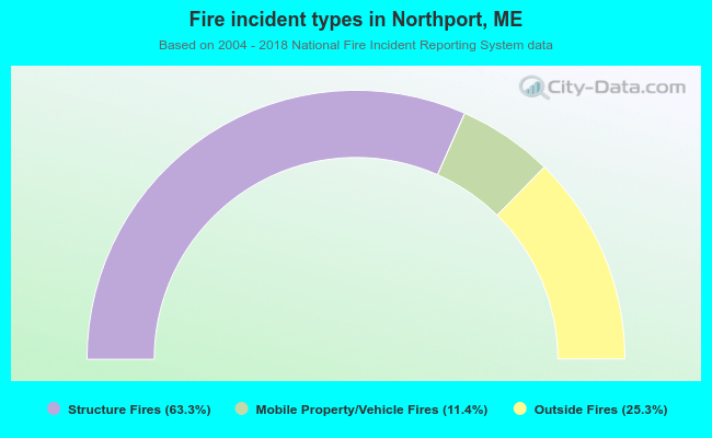 When looking into fire subcategories, the most incidents belonged to: Structure Fires (63.3%), and Outside Fires (25.3%).
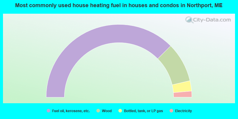
- 75.1%Fuel oil, kerosene, etc.
- 17.6%Wood
- 4.6%Bottled, tank, or LP gas
- 2.7%Electricity
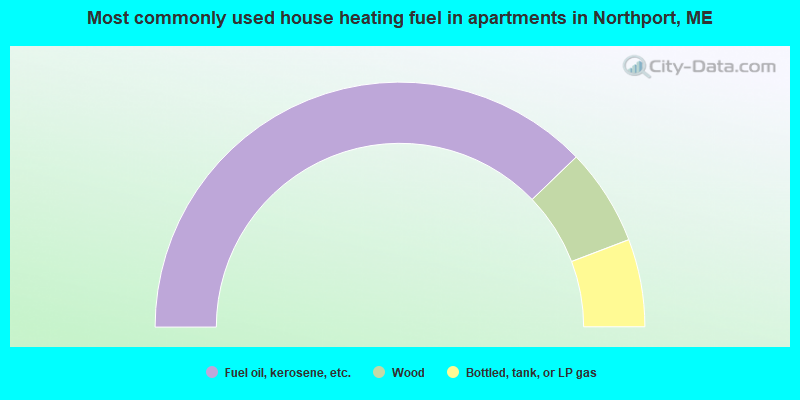
- 75.6%Fuel oil, kerosene, etc.
- 12.8%Wood
- 11.6%Bottled, tank, or LP gas
Northport compared to Maine state average:
- Unemployed percentage significantly below state average.
- Black race population percentage significantly below state average.
- Hispanic race population percentage below state average.
- Median age above state average.
- Renting percentage below state average.
- Length of stay since moving in significantly above state average.
- Number of rooms per house significantly below state average.
- House age significantly below state average.
- Number of college students below state average.

|
Total of 2 patent applications in 2008-2024.