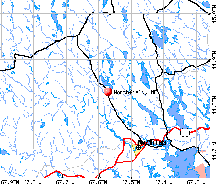
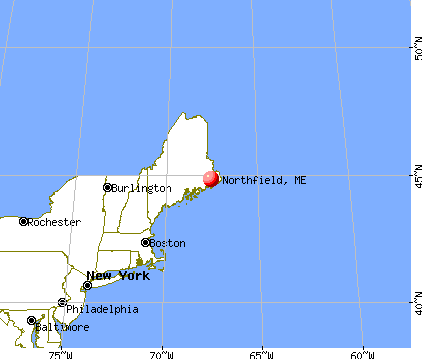
Northfield, Maine
Submit your own pictures of this town and show them to the world
- OSM Map
- General Map
- Google Map
- MSN Map
Population change since 2000: +13.0%
 |
| Males: 75 | |
| Females: 73 |
| Median resident age: | 55.2 years |
| Maine median age: | 43.0 years |
Zip code: 04654
| Northfield: | $73,774 |
| ME: | $69,543 |
Estimated per capita income in 2022: $52,022 (it was $23,048 in 2000)
Estimated median house or condo value in 2022: $252,995 (it was $104,200 in 2000)
| Northfield: | $252,995 |
| ME: | $290,600 |
Mean prices in 2022: all housing units: $208,896; detached houses: $229,377; townhouses or other attached units: $190,242; in 2-unit structures: $139,050; in 3-to-4-unit structures: $456,045; in 5-or-more-unit structures: $413,457; mobile homes: $94,515; occupied boats, rvs, vans, etc.: $45,679


- 14698.6%White alone
- 21.4%Black alone

According to our research of Maine and other state lists, there were 2 registered sex offenders living in Northfield, Maine as of May 23, 2024.
The ratio of all residents to sex offenders in Northfield is 74 to 1.
 Recent articles from our blog. Our writers, many of them Ph.D. graduates or candidates, create easy-to-read articles on a wide variety of topics.

Latest news from Northfield, ME collected exclusively by city-data.com from local newspapers, TV, and radio stations
Ancestries: English (28.2%), Irish (13.0%), German (10.7%), French (3.8%), French Canadian (3.1%), Scottish (3.1%).
Current Local Time: EST time zone
Incorporated on 03/21/1838
Elevation: 265 feet
Land area: 43.7 square miles.
Population density: 3.4 people per square mile (very low).
2 residents are foreign born
| This town: | 1.5% |
| Maine: | 2.9% |
| Northfield town: | 0.6% ($580) |
| Maine: | 1.5% ($1,417) |
Nearest city with pop. 50,000+: Portland, ME  (154.5 miles , pop. 64,249).
Nearest city with pop. 200,000+: Boston, MA (246.0 miles , pop. 589,141).
Nearest city with pop. 1,000,000+: Bronx, NY (420.4 miles , pop. 1,332,650).
Nearest cities:
), ), ), Latitude: 44.83 N, Longitude: 67.61 W
Area code commonly used in this area: 207

Single-family new house construction building permits:
- 2020: 1 building, cost: $156,800
- 2018: 2 buildings, average cost: $106,300
- 2004: 5 buildings, average cost: $75,000
- 2003: 5 buildings, average cost: $75,000
- 2002: 2 buildings, average cost: $130,700
- 2001: 1 building, cost: $118,000
- 2000: 1 building, cost: $118,000
- 1997: 4 buildings, average cost: $25,000


| Here: | 1.4% |
| Maine: | 3.4% |


- Health care (22.1%)
- Construction (9.1%)
- Public administration (9.1%)
- Educational services (9.1%)
- Agriculture, forestry, fishing & hunting (7.8%)
- Broadcasting & telecommunications (7.8%)
- Used merchandise, gift, novelty, souvenir, other miscellaneous stores (6.5%)

- Construction (16.3%)
- Health care (16.3%)
- Agriculture, forestry, fishing & hunting (14.0%)
- Broadcasting & telecommunications (14.0%)
- Petroleum & petroleum products merchant wholesalers (7.0%)
- Used merchandise, gift, novelty, souvenir, other miscellaneous stores (7.0%)
- Public administration (7.0%)

- Health care (29.4%)
- Educational services (14.7%)
- Public administration (11.8%)
- Sporting goods, camera, hobby & toy stores (8.8%)
- Arts, entertainment, recreation (8.8%)
- Accommodation & food services (8.8%)
- Food & beverage stores (5.9%)

- Other management occupations, except farmers and farm managers (11.7%)
- Registered nurses (10.4%)
- Electrical equipment mechanics and other installation, maintenance, and repair workers, including supervisors (7.8%)
- Information and record clerks, except customer service representatives (6.5%)
- Cashiers (6.5%)
- Construction traders workers except carpenters, electricians, painters, plumbers, and construction laborers (6.5%)
- Other office and administrative support workers, including supervisors (5.2%)

- Electrical equipment mechanics and other installation, maintenance, and repair workers, including supervisors (14.0%)
- Other management occupations, except farmers and farm managers (11.6%)
- Registered nurses (11.6%)
- Construction traders workers except carpenters, electricians, painters, plumbers, and construction laborers (11.6%)
- Bookkeeping, accounting, and auditing clerks (7.0%)
- Fishing, hunting, and forestry occupations (7.0%)
- Other material moving workers, except laborers (7.0%)

- Cashiers (14.7%)
- Information and record clerks, except customer service representatives (11.8%)
- Other management occupations, except farmers and farm managers (11.8%)
- Other office and administrative support workers, including supervisors (11.8%)
- Waiters and waitresses (8.8%)
- Other teachers, instructors, education, training, and library occupations (8.8%)
- Social scientists and related workers (8.8%)
Average climate in Northfield, Maine
Based on data reported by over 4,000 weather stations


(lower is better)

Air Quality Index (AQI) level in 2023 was 50.1. This is significantly better than average.
| City: | 50.1 |
| U.S.: | 72.6 |

Ozone [ppb] level in 2023 was 31.5. This is about average. Closest monitor was 13.9 miles away from the city center.
| City: | 31.5 |
| U.S.: | 33.3 |
Earthquake activity:
Northfield-area historical earthquake activity is significantly above Maine state average. It is 84% smaller than the overall U.S. average.On 10/16/2012 at 23:12:25, a magnitude 4.7 (4.7 ML, Depth: 10.0 mi, Class: Light, Intensity: IV - V) earthquake occurred 173.5 miles away from Northfield center
On 4/20/2002 at 10:50:47, a magnitude 5.3 (5.3 ML, Depth: 3.0 mi, Class: Moderate, Intensity: VI - VII) earthquake occurred 300.2 miles away from the city center
On 4/20/2002 at 10:50:47, a magnitude 5.2 (5.2 MB, 4.2 MS, 5.2 MW, 5.0 MW) earthquake occurred 301.5 miles away from Northfield center
On 1/19/1982 at 00:14:42, a magnitude 4.7 (4.5 MB, 4.7 MD, 4.5 LG) earthquake occurred 218.4 miles away from the city center
On 10/7/1983 at 10:18:46, a magnitude 5.3 (5.1 MB, 5.3 LG, 5.1 ML) earthquake occurred 338.2 miles away from Northfield center
On 10/3/2006 at 00:07:38, a magnitude 3.7 (3.7 MD, Depth: 6.2 mi, Class: Light, Intensity: II - III) earthquake occurred 41.7 miles away from Northfield center
Magnitude types: regional Lg-wave magnitude (LG), body-wave magnitude (MB), duration magnitude (MD), local magnitude (ML), surface-wave magnitude (MS), moment magnitude (MW)
Natural disasters:
The number of natural disasters in Washington County (20) is greater than the US average (15).Major Disasters (Presidential) Declared: 14
Emergencies Declared: 6
Causes of natural disasters: Floods: 11, Storms: 10, Snows: 5, Winds: 2, Winter Storms: 2, Blizzard: 1, Heavy Rain: 1, Hurricane: 1, Ice Storm: 1, Landslide: 1, Snowfall: 1, Other: 2 (Note: some incidents may be assigned to more than one category).

Colleges/universities with over 2000 students nearest to Northfield:
- University of Maine (about 53 miles; Orono, ME; Full-time enrollment: 8,931)
- Husson University (about 59 miles; Bangor, ME; FT enrollment: 2,421)
- University of Maine at Augusta (about 114 miles; Augusta, ME; FT enrollment: 3,204)
- University of Maine at Farmington (about 126 miles; Farmington, ME; FT enrollment: 2,036)
- Southern Maine Community College (about 154 miles; South Portland, ME; FT enrollment: 4,666)
- University of Southern Maine (about 155 miles; Portland, ME; FT enrollment: 6,647)
- Saint Joseph's College of Maine (about 159 miles; Standish, ME; FT enrollment: 2,010)
Points of interest:
Lakes: Bog Lake (A), Fulton Lake (B), Horseshoe Lake (C), Long Lake (D), Pug Heath (E), Pug Lake (F). Display/hide their locations on the map
Streams, rivers, and creeks: Soddy Meadow Brook (A), Joe Meadow Brook (B), Holmes Brook (C), Palmer Brook (D), Old Stream (E), Bryant Brook (F), Bog Stream (G), New Stream (H), Bear Brook (I). Display/hide their locations on the map
| This town: | 2.0 people |
| Maine: | 2.3 people |
| This town: | 63.5% |
| Whole state: | 62.9% |
| This town: | 6.8% |
| Whole state: | 9.4% |
No gay or lesbian households reported
| This town: | 7.1% |
| Whole state: | 10.9% |
| This town: | 3.1% |
| Whole state: | 4.1% |
For population 15 years and over in Northfield:

- Never married: 17.0%
- Now married: 58.9%
- Separated: 0.0%
- Widowed: 8.0%
- Divorced: 16.1%
For population 25 years and over in Northfield:
- High school or higher: 95.0%
- Bachelor's degree or higher: 29.0%
- Graduate or professional degree: 18.0%
- Mean travel time to work (commute): 18.2 minutes


| Here: | 11.5 |
| Maine average: | 11.2 |
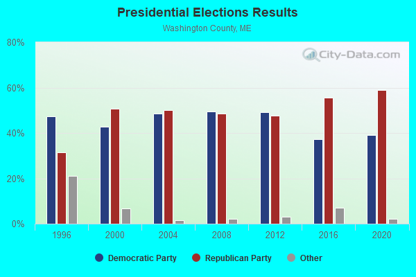

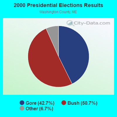

Graphs represent county-level data. Detailed 2008 Election Results
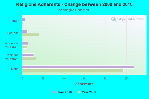
Religion statistics for Northfield, ME (based on Washington County data)
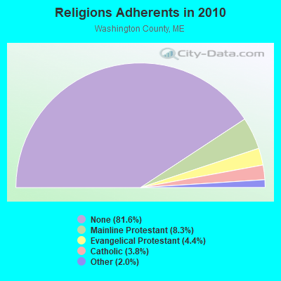
| Religion | Adherents | Congregations |
|---|---|---|
| Mainline Protestant | 2,731 | 37 |
| Evangelical Protestant | 1,442 | 31 |
| Catholic | 1,238 | 10 |
| Other | 648 | 13 |
| None | 26,797 | - |
Food Environment Statistics:
| Here: | 4.89 / 10,000 pop. |
| Maine: | 2.80 / 10,000 pop. |
| Washington County: | 1.22 / 10,000 pop. |
| Maine: | 2.20 / 10,000 pop. |
| This county: | 9.78 / 10,000 pop. |
| Maine: | 5.75 / 10,000 pop. |
| This county: | 11.31 / 10,000 pop. |
| Maine: | 11.02 / 10,000 pop. |
| Here: | 9.4% |
| Maine: | 8.2% |
| Here: | 28.3% |
| State: | 25.0% |
Strongest AM radio stations in Northfield:
- WZON (620 AM; 5 kW; BANGOR, ME; Owner: THE ZONE CORPORATION)
- WABI (910 AM; 5 kW; BANGOR, ME; Owner: CLEAR CHANNEL BROADCASTING LICENSES, INC.)
- WDEA (1370 AM; 5 kW; ELLSWORTH, ME; Owner: CUMULUS LICENSING CORP.)
- WRKO (680 AM; 50 kW; BOSTON, MA; Owner: ENTERCOM BOSTON LICENSE, LLC)
- WEEI (850 AM; 50 kW; BOSTON, MA; Owner: ENTERCOM BOSTON LICENSE, LLC)
- WBZ (1030 AM; 50 kW; BOSTON, MA; Owner: INFINITY BROADCASTING OPERATIONS, INC.)
- WSKW (1160 AM; 10 kW; SKOWHEGAN, ME; Owner: MOUNTAIN WIRELESS, INCORPORATED)
- WCRN (830 AM; 50 kW; WORCESTER, MA; Owner: CARTER BROADCASTING CORPORATION)
- WNNZ (640 AM; 50 kW; WESTFIELD, MA; Owner: CLEAR CHANNEL BROADCASTING LICENSES, INC.)
- WALE (990 AM; 50 kW; GREENVILLE, RI; Owner: NORTH AMERICAN BROADCASTING CO., INC.)
- WKOX (1200 AM; 50 kW; FRAMINGHAM, MA; Owner: CAPSTAR TX LIMITED PARTNERSHIP)
- WREM (710 AM; daytime; 5 kW; MONTICELLO, ME; Owner: ALLAN H WEINER)
- WTME (780 AM; 10 kW; RUMFORD, ME; Owner: MOUNTAIN VALLEY BROADCASTING, INC.)
Strongest FM radio stations in Northfield:
- WALZ-FM (95.3 FM; MACHIAS, ME; Owner: WILLIAM MCVICAR & ROGER HOLST, GEN. PARTNERSHIP)
- WHCF (88.5 FM; BANGOR, ME; Owner: BANGOR BAPTIST CHURCH)
- WNSX (97.7 FM; WINTER HARBOR, ME; Owner: CLEAR CHANNEL BROADCASTING LICENSES, INC.)
- WMED (89.7 FM; CALAIS, ME; Owner: MAINE PUBLIC BROADCASTING CORPORATION)
- WCRQ (102.9 FM; DENNYSVILLE, ME; Owner: WQDY, INC.)
- WVOM (103.9 FM; HOWLAND, ME; Owner: CLEAR CHANNEL BROADCASTING LICENSES, INC.)
- WBQI (107.7 FM; BAR HARBOR, ME; Owner: MARINER BROADCASTING, L.P.)
TV broadcast stations around Northfield:
- W21BH (Channel 21; MACHIAS, ME; Owner: TRINITY BROADCASTING NETWORK)
FCC Registered Antenna Towers:
5- Robert Parsloe, Eastern Ridge Road (Lat: 44.831056 Lon: -67.561444), Type: 59.7, Structure height: 23029 m, Overall height: 57.9 m, Registrant: Rising Tide Towers LLC, Rparsloe@wireless-Partnersllc.Com, , Portl-and, Phone: (207) 808-5000
- Robert Parsloe, Eastern Ridge Road (Lat: 44.831056 Lon: -67.561444), Type: 59.7, Structure height: 23029 m, Overall height: 57.9 m, Registrant: Rising Tide Towers LLC, Rparsloe@wireless-Partnersllc.Com, , Portl-and, Phone: (207) 808-5000
- Robert Parsloe, Eastern Ridge Road (Lat: 44.831056 Lon: -67.561444), Type: 59.7, Structure height: 23029 m, Overall height: 57.9 m, Registrant: Rising Tide Towers LLC, Rparsloe@wireless-Partnersllc.Com, , Portl-and, Phone: (207) 808-5000
- Robert Parsloe, Eastern Ridge Road (Lat: 44.831056 Lon: -67.561444), Type: 59.7, Structure height: 23029 m, Overall height: 57.9 m, Registrant: Rising Tide Towers LLC, Rparsloe@wireless-Partnersllc.Com, , Portl-and, Phone: (207) 808-5000
- Edward G Roach, Eastern Ridge Road (Lat: 44.831056 Lon: -67.561444), Type: 59.7, Structure height: 23029 m, Overall height: 57.9 m, Registrant: Sba Towers Xi, LLC, Eroach@sbasite.Com, , Boca -Raton, Phone: (561) 995-7670
FCC Registered Amateur Radio Licenses:
1- Call Sign: KB1IMW, Licensee ID: L00534026, Grant Date: 04/29/2023, Expiration Date: 04/29/2033, Certifier: Susan M Chessa, Registrant: Susan M Chessa, 6 Holway Drive, Northfield, ME 04654

- 51.3%Fuel oil, kerosene, etc.
- 41.0%Wood
- 7.7%Bottled, tank, or LP gas

- 75.0%Fuel oil, kerosene, etc.
- 16.7%Wood
- 8.3%Bottled, tank, or LP gas
Northfield compared to Maine state average:
- Unemployed percentage significantly below state average.
- Hispanic race population percentage significantly below state average.
- Median age significantly above state average.
- Foreign-born population percentage significantly below state average.
- Renting percentage below state average.
- Length of stay since moving in significantly above state average.
- Number of rooms per house significantly below state average.
- House age significantly below state average.