North of the River, Tennessee
Submit your own pictures of this place and show them to the world
- OSM Map
- General Map
- Google Map
- MSN Map

| Males: 864 | |
| Females: 904 |
| Median resident age: | 43.1 years |
| Tennessee median age: | 35.9 years |
Zip code: 38562
| North of the River: | $45,170 |
| TN: | $65,254 |
Estimated per capita income in 2022: $25,693 (it was $14,840 in 2000)
North of the River CCD income, earnings, and wages data
Estimated median house or condo value in 2022: $160,874 (it was $68,100 in 2000)
| North of the River: | $160,874 |
| TN: | $284,800 |
North of the River, TN residents, houses, and apartments details
Detailed information about poverty and poor residents in North of the River, TN


- 1,75297.4%White alone
- 191.1%Hispanic
- 170.9%Two or more races
- 80.4%American Indian alone
- 20.1%Black alone

Races in North of the River detailed stats: ancestries, foreign born residents, place of birth
 Recent articles from our blog. Our writers, many of them Ph.D. graduates or candidates, create easy-to-read articles on a wide variety of topics.
Current Local Time: CST time zone
Land area: 120.7 square miles.
Population density: 15 people per square mile (very low).

| North of the River CCD: | 0.5% ($360) |
| Tennessee: | 0.8% ($715) |
Nearest city with pop. 50,000+: Murfreesboro, TN  (52.7 miles , pop. 68,816).
Nearest city with pop. 200,000+: Nashville-Davidson, TN (59.3 miles , pop. 545,524).
Nearest city with pop. 1,000,000+: Chicago, IL (389.6 miles , pop. 2,896,016).
Nearest cities:
), ), ), ), ), Latitude: 36.41 N, Longitude: 85.75 W


| Here: | 3.6% |
| Tennessee: | 3.0% |

- Construction (11.4%)
- Transportation equipment (10.8%)
- Miscellaneous manufacturing (8.3%)
- Agriculture, forestry, fishing & hunting (8.2%)
- Educational services (6.7%)
- Health care (5.7%)
- Finance & insurance (4.8%)

- Construction (21.1%)
- Agriculture, forestry, fishing & hunting (15.1%)
- Miscellaneous manufacturing (10.3%)
- Transportation equipment (7.8%)
- Plastics & rubber products (6.6%)
- Broadcasting & telecommunications (5.5%)
- Metal & metal products (3.0%)

- Educational services (14.5%)
- Transportation equipment (14.2%)
- Health care (11.0%)
- Finance & insurance (8.1%)
- Social assistance (7.3%)
- Miscellaneous manufacturing (5.9%)
- Public administration (5.6%)

- Other production occupations, including supervisors (8.9%)
- Metal workers and plastic workers (7.7%)
- Assemblers and fabricators (6.1%)
- Fishing, hunting, and forestry occupations (5.9%)
- Other office and administrative support workers, including supervisors (4.6%)
- Preschool, kindergarten, elementary, and middle school teachers (4.3%)
- Material recording, scheduling, dispatching, and distributing workers (4.2%)

- Fishing, hunting, and forestry occupations (11.0%)
- Metal workers and plastic workers (9.6%)
- Other production occupations, including supervisors (9.4%)
- Carpenters (5.5%)
- Material recording, scheduling, dispatching, and distributing workers (5.3%)
- Other management occupations, except farmers and farm managers (4.1%)
- Construction laborers (3.9%)

- Assemblers and fabricators (9.9%)
- Preschool, kindergarten, elementary, and middle school teachers (9.4%)
- Other production occupations, including supervisors (8.3%)
- Other office and administrative support workers, including supervisors (7.3%)
- Secretaries and administrative assistants (6.5%)
- Building and grounds cleaning and maintenance occupations (5.6%)
- Metal workers and plastic workers (5.4%)
Average climate in North of the River, Tennessee
Based on data reported by over 4,000 weather stations


(lower is better)

Air Quality Index (AQI) level in 2022 was 56.8. This is better than average.
| City: | 56.8 |
| U.S.: | 72.6 |

Nitrogen Dioxide (NO2) [ppb] level in 2007 was 2.13. This is significantly better than average. Closest monitor was 24.0 miles away from the city center.
| City: | 2.13 |
| U.S.: | 5.11 |

Sulfur Dioxide (SO2) [ppb] level in 2007 was 1.72. This is about average. Closest monitor was 21.1 miles away from the city center.
| City: | 1.72 |
| U.S.: | 1.51 |

Ozone [ppb] level in 2007 was 44.0. This is worse than average. Closest monitor was 24.0 miles away from the city center.
| City: | 44.0 |
| U.S.: | 33.3 |

Particulate Matter (PM2.5) [µg/m3] level in 2022 was 6.46. This is better than average. Closest monitor was 21.1 miles away from the city center.
| City: | 6.46 |
| U.S.: | 8.11 |
Tornado activity:
North of the River-area historical tornado activity is near Tennessee state average. It is 53% greater than the overall U.S. average.
On 4/3/1974, a category F4 (max. wind speeds 207-260 mph) tornado 26.7 miles away from the North of the River place center killed 10 people and injured 113 people and caused between $5000 and $50,000 in damages.
On 3/26/1959, a category F3 (max. wind speeds 158-206 mph) tornado 2.0 miles away from the place center caused between $50,000 and $500,000 in damages.
Earthquake activity:
North of the River-area historical earthquake activity is significantly above Tennessee state average. It is 144% greater than the overall U.S. average.On 4/18/2008 at 09:36:59, a magnitude 5.4 (5.1 MB, 4.8 MS, 5.4 MW, 5.2 MW, Class: Moderate, Intensity: VI - VII) earthquake occurred 183.7 miles away from North of the River center
On 7/27/1980 at 18:52:21, a magnitude 5.2 (5.1 MB, 4.7 MS, 5.0 UK, 5.2 UK) earthquake occurred 158.9 miles away from North of the River center
On 4/18/2008 at 09:36:59, a magnitude 5.2 (5.2 MW, Depth: 8.9 mi) earthquake occurred 183.7 miles away from North of the River center
On 4/29/2003 at 08:59:39, a magnitude 4.9 (4.4 MB, 4.6 MW, 4.9 LG, Class: Light, Intensity: IV - V) earthquake occurred 132.7 miles away from North of the River center
On 6/18/2002 at 17:37:15, a magnitude 5.0 (4.3 MB, 4.6 MW, 5.0 LG) earthquake occurred 156.3 miles away from North of the River center
On 11/30/1973 at 07:48:41, a magnitude 4.7 (4.7 MB, 4.6 ML) earthquake occurred 108.3 miles away from North of the River center
Magnitude types: regional Lg-wave magnitude (LG), body-wave magnitude (MB), local magnitude (ML), surface-wave magnitude (MS), moment magnitude (MW)
Natural disasters:
The number of natural disasters in Jackson County (27) is a lot greater than the US average (15).Major Disasters (Presidential) Declared: 22
Emergencies Declared: 2
Causes of natural disasters: Storms: 22, Floods: 21, Tornadoes: 9, Winds: 5, Winter Storms: 2, Flash Flood: 1, Hurricane: 1, Ice Storm: 1, Landslide: 1, Mudslide: 1, Snowfall: 1, Other: 1 (Note: some incidents may be assigned to more than one category).
Hospitals and medical centers near North of the River:
- MABRY HEALTH CARE (Nursing Home, about 7 miles away; GAINESBORO, TN)
- THE PALACE (Nursing Home, about 11 miles away; RED BOILING SPRINGS, TN)
- KINDRED NURSING AND REHABILITATION-SMITH COUNTY (Nursing Home, about 16 miles away; CARTHAGE, TN)
- RIVERVIEW REGIONAL MEDICAL CENTER NORTH (Hospital, about 16 miles away; CARTHAGE, TN)
Colleges/universities with over 2000 students nearest to North of the River:
- Tennessee Technological University (about 22 miles; Cookeville, TN; Full-time enrollment: 9,761)
- Volunteer State Community College (about 42 miles; Gallatin, TN; FT enrollment: 5,311)
- Middle Tennessee State University (about 52 miles; Murfreesboro, TN; FT enrollment: 21,628)
- Lindsey Wilson College (about 54 miles; Columbia, KY; FT enrollment: 2,552)
- Western Kentucky University (about 56 miles; Bowling Green, KY; FT enrollment: 16,942)
- Southcentral Kentucky Community and Technical College (about 57 miles; Bowling Green, KY; FT enrollment: 2,794)
- Trevecca Nazarene University (about 60 miles; Nashville, TN; FT enrollment: 2,223)
Points of interest:
Notable locations in North of the River: Dycus Landing (A), Gainesboro Landing (B), Halls Landing (C), Lock Branch Landing (D), Woodforks Landing (E), West End Volunteer Fire Department (F), Jennings Creek Volunteer Fire Department (G), Tennessee Department of Agriculture Division of Forestry Haydenburg Fire Tower (H). Display/hide their locations on the map
Churches in North of the River include: Smith Memorial Church (A), Beech Grove Church (B), Indian Creek Church (C), Pleasant Grove Church (D), Pleasant Valley Church (E), South Fork Church (F), Richmond Chapel (G), Salt Lick Baptist Church (H), Wartrace United Methodist Church (I). Display/hide their locations on the map
Cemeteries: Wartrace Cemetery (1), Holland Cemetery (2), Clark Cemetery (3), Draper Cemetery (4), Clark Cemetery (5), Minchey Cemetery (6), Cub Creek Cemetery (7). Display/hide their locations on the map
Reservoirs: Lake Number Fifteen (A), Lake Number Three (B), Cordell Hull Reservoir (C), Jennings Creek Watershed Number Ten Lake (D), Lake Number Thirteen (E), Lake Number Six (F), Lake Number Five (G), Jennings Creek Lake Number Eighteen (H). Display/hide their locations on the map
Streams, rivers, and creeks: Lock Branch (A), Lick Branch (B), Keeling Branch (C), Webster Branch (D), Hicks Branch (E), Hensley Creek (F), Germany Branch (G), Funns Branch (H), Crabtree Creek (I). Display/hide their locations on the map
Park in North of the River: Salt Lick Creek Recreation Area (1). Display/hide its location on the map
| This place: | 2.3 people |
| Tennessee: | 2.5 people |
| This place: | 58.1% |
| Whole state: | 69.8% |
| This place: | 3.8% |
| Whole state: | 4.2% |
Likely homosexual households (counted as self-reported same-sex unmarried-partner households)
- Lesbian couples: 0.0% of all households
- Gay men: 0.1% of all households
| This place: | 16.4% |
| Whole state: | 13.5% |
| This place: | 8.3% |
| Whole state: | 5.8% |
For population 15 years and over in North of the River:

- Never married: 14.2%
- Now married: 63.3%
- Separated: 1.9%
- Widowed: 10.9%
- Divorced: 11.6%
For population 25 years and over in North of the River:
- High school or higher: 61.6%
- Bachelor's degree or higher: 6.9%
- Graduate or professional degree: 0.6%
- Unemployed: 4.0%
- Mean travel time to work (commute): 38.5 minutes


| Here: | 14.0 |
| Tennessee average: | 13.3 |
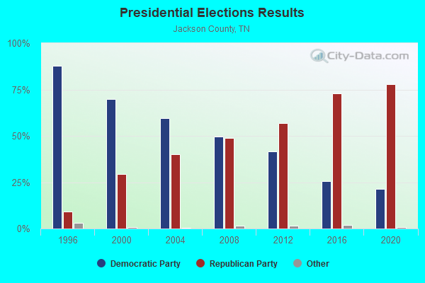
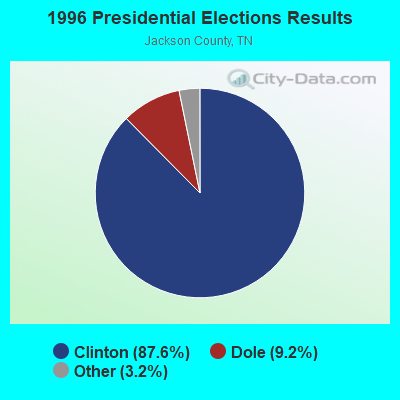
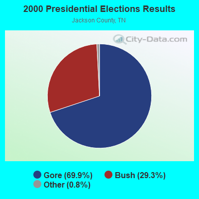

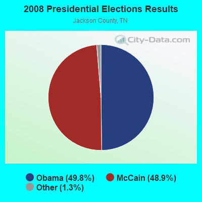
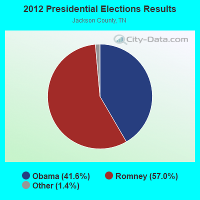


Graphs represent county-level data. Detailed 2008 Election Results
Religion statistics for North of the River, TN (based on Jackson County data)
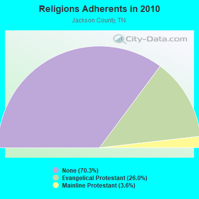
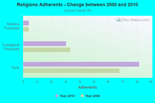
| Religion | Adherents | Congregations |
|---|---|---|
| Evangelical Protestant | 3,031 | 41 |
| Mainline Protestant | 422 | 6 |
| Other | 5 | 2 |
| Catholic | - | - |
| None | 8,180 | - |
Food Environment Statistics:
| Here: | 2.78 / 10,000 pop. |
| Tennessee: | 1.99 / 10,000 pop. |
| Jackson County: | 7.41 / 10,000 pop. |
| Tennessee: | 5.16 / 10,000 pop. |
| Here: | 7.41 / 10,000 pop. |
| Tennessee: | 6.56 / 10,000 pop. |
| Here: | 13.3% |
| Tennessee: | 11.4% |
| Here: | 31.6% |
| Tennessee: | 30.2% |
| This county: | 14.9% |
| Tennessee: | 13.5% |
Strongest AM radio stations in North of the River:
- WSM (650 AM; 50 kW; NASHVILLE, TN; Owner: GAYLORD ENTERTAINMENT COMPANY)
- WAMB (1160 AM; 50 kW; DONELSON, TN; Owner: GREAT SOUTHERN BROADCASTING COMPANY, INC.)
- WLAC (1510 AM; 50 kW; NASHVILLE, TN; Owner: CAPSTAR TX LIMITED PARTNERSHIP)
- WKDA (1200 AM; 50 kW; NASHVILLE, TN; Owner: RADIO NASHVILLE, INC.)
- WNQM (1300 AM; 50 kW; NASHVILLE, TN; Owner: WNQM. INC.)
- WWAM (820 AM; daytime; 50 kW; JASPER, TN; Owner: SHELTON BROADCASTING SYSTEM)
- WKVL (850 AM; daytime; 50 kW; KNOXVILLE, TN; Owner: HORNE RADIO, LLC)
- WFLI (1070 AM; 50 kW; LOOKOUT MOUNTAIN, TN; Owner: WFLI, INC.)
- WPLN (1430 AM; 15 kW; MADISON, TN)
- WHAS (840 AM; 50 kW; LOUISVILLE, KY; Owner: CLEAR CHANNEL BROADCASTING LICENSES, INC.)
- WATX (1590 AM; 2 kW; ALGOOD, TN; Owner: JWC BROADCASTING)
- WTKY (1370 AM; daytime; 2 kW; TOMPKINSVILLE, KY; Owner: WHITTIMORE ENTERPRISES, INC.)
- WHIN (1010 AM; 5 kW; GALLATIN, TN; Owner: WHIN, INC.)
Strongest FM radio stations in North of the River:
- WBXE (93.7 FM; BAXTER, TN; Owner: JWC BROADCASTING)
- WGSQ (94.7 FM; COOKEVILLE, TN; Owner: CLEAR CHANNEL BROADCASTING LICENSES, INC.)
- WUCZ (104.1 FM; CARTHAGE, TN; Owner: WOOD BROADCASTING, INC.)
- WVFB (101.5 FM; CELINA, TN; Owner: ELIZABETH BERNICE WHITTIMORE)
- WLQK (95.9 FM; LIVINGSTON, TN; Owner: JWC BROADCASTING)
- WWOG (90.9 FM; COOKEVILLE, TN; Owner: SOMERSET EDUCATIONAL BROADCASTING FOUNDATION)
- WKWY (102.7 FM; TOMPKINSVILLE, KY; Owner: J.K. WHITTIMORE)
- WLIV-FM (104.7 FM; MONTEREY, TN; Owner: WKXN INC)
- WLCT (102.1 FM; LAFAYETTE, TN; Owner: LAFAYETTE BROADCASTING CO., INC.)
- WMOT (89.5 FM; MURFREESBORO, TN; Owner: MIDDLE TENNESSEE STATE UNIVERSITY)
- WGIC (98.5 FM; COOKEVILLE, TN; Owner: CLEAR CHANNEL BROADCASTING LICENSES, INC.)
- WGGC (95.1 FM; GLASGOW, KY; Owner: HERITAGE COMMUNICATIONS, INC.)
- WKXD-FM (106.9 FM; MONTEREY, TN; Owner: JWC BROADCASTING)
- W206AJ (89.1 FM; COOKEVILLE, TN; Owner: WAY-FM MEDIA GROUP, INC.)
- WHRS (91.7 FM; COOKEVILLE, TN; Owner: NASHVILLE PUBLIC RADIO)
TV broadcast stations around North of the River:
- WCTE (Channel 22; COOKEVILLE, TN; Owner: UPPER CUMBERLAND BROADCAST COUNCIL)
- WPGD (Channel 50; HENDERSONVILLE, TN; Owner: TRINITY BROADCASTING NETWORK)

- 46.2%Electricity
- 31.2%Bottled, tank, or LP gas
- 20.8%Wood
- 1.8%Fuel oil, kerosene, etc.

- 71.5%Electricity
- 10.3%Utility gas
- 9.7%Wood
- 4.8%Fuel oil, kerosene, etc.
- 3.6%Bottled, tank, or LP gas
North of the River compared to Tennessee state average:
- Median house value below state average.
- Unemployed percentage significantly below state average.
- Black race population percentage significantly below state average.
- Hispanic race population percentage significantly below state average.
- Foreign-born population percentage significantly below state average.
- Renting percentage significantly below state average.
- Length of stay since moving in significantly above state average.
- Number of rooms per house significantly below state average.
- House age significantly below state average.
- Number of college students significantly below state average.
- Percentage of population with a bachelor's degree or higher significantly below state average.