New Liberty, Kentucky
Submit your own pictures of this place and show them to the world
- OSM Map
- General Map
- Google Map
- MSN Map

| Males: 1,519 | |
| Females: 1,457 |
| Median resident age: | 36.0 years |
| Kentucky median age: | 35.9 years |
Zip code: 41086
| New Liberty: | $62,527 |
| KY: | $59,341 |
Estimated per capita income in 2022: $28,460 (it was $15,316 in 2000)
New Liberty CCD income, earnings, and wages data
Estimated median house or condo value in 2022: $181,315 (it was $77,800 in 2000)
| New Liberty: | $181,315 |
| KY: | $196,300 |
Mean prices in 2022: all housing units: $186,990; detached houses: $214,846; townhouses or other attached units: $248,959; mobile homes: $111,679
Detailed information about poverty and poor residents in New Liberty, KY


- 2,63495.0%White alone
- 702.5%Black alone
- 351.3%Hispanic
- 180.6%Two or more races
- 90.3%American Indian alone
- 50.2%Asian alone
- 20.07%Other race alone

Races in New Liberty detailed stats: ancestries, foreign born residents, place of birth
According to our research of Kentucky and other state lists, there was 1 registered sex offender living in New Liberty, Kentucky as of May 23, 2024.
The ratio of all residents to sex offenders in New Liberty is 2,976 to 1.
The ratio of registered sex offenders to all residents in this city is much lower than the state average.
 Recent articles from our blog. Our writers, many of them Ph.D. graduates or candidates, create easy-to-read articles on a wide variety of topics.
Current Local Time: EST time zone
Land area: 104.8 square miles.
Population density: 28 people per square mile (very low).

| New Liberty CCD: | 0.6% ($441) |
| Kentucky: | 0.8% ($610) |
Nearest city with pop. 50,000+: Cincinnati, OH  (40.5 miles , pop. 331,285).
Nearest city with pop. 1,000,000+: Chicago, IL (265.3 miles , pop. 2,896,016).
Nearest cities:
), ), ), Latitude: 38.64 N, Longitude: 84.90 W
Area code: 502


| Here: | 3.4% |
| Kentucky: | 3.8% |

- Construction (9.9%)
- Health care (8.0%)
- Educational services (5.9%)
- Transportation equipment (5.4%)
- Public administration (5.2%)
- Agriculture, forestry, fishing & hunting (5.1%)
- Accommodation & food services (4.0%)

- Construction (17.3%)
- Agriculture, forestry, fishing & hunting (8.4%)
- Metal & metal products (4.3%)
- Transportation equipment (4.1%)
- Real estate & rental & leasing (3.8%)
- Chemicals (3.7%)
- Truck transportation (3.5%)

- Health care (18.0%)
- Educational services (10.0%)
- Public administration (8.7%)
- Transportation equipment (7.3%)
- Accommodation & food services (5.4%)
- Personal & laundry services (4.7%)
- Chemicals (3.6%)

- Other management occupations, except farmers and farm managers (7.0%)
- Other production occupations, including supervisors (6.7%)
- Material recording, scheduling, dispatching, and distributing workers (6.4%)
- Metal workers and plastic workers (3.8%)
- Other sales and related occupations, including supervisors (3.6%)
- Driver/sales workers and truck drivers (3.5%)
- Farmers and farm managers (3.5%)

- Other production occupations, including supervisors (7.2%)
- Material recording, scheduling, dispatching, and distributing workers (6.9%)
- Driver/sales workers and truck drivers (6.1%)
- Other management occupations, except farmers and farm managers (5.7%)
- Farmers and farm managers (5.6%)
- Other sales and related occupations, including supervisors (5.0%)
- Metal workers and plastic workers (5.0%)

- Other management occupations, except farmers and farm managers (8.7%)
- Registered nurses (6.7%)
- Other production occupations, including supervisors (6.2%)
- Retail sales workers, except cashiers (5.8%)
- Material recording, scheduling, dispatching, and distributing workers (5.6%)
- Preschool, kindergarten, elementary, and middle school teachers (4.9%)
- Secretaries and administrative assistants (4.2%)
Average climate in New Liberty, Kentucky
Based on data reported by over 4,000 weather stations


Tornado activity:
New Liberty-area historical tornado activity is slightly above Kentucky state average. It is 63% greater than the overall U.S. average.
On 4/3/1974, a category F5 (max. wind speeds 261-318 mph) tornado 22.7 miles away from the New Liberty place center killed 3 people and injured 210 people.
On 11/22/1992, a category F4 (max. wind speeds 207-260 mph) tornado 9.4 miles away from the place center killed one person and injured 10 people and caused between $500,000 and $5,000,000 in damages.
Earthquake activity:
New Liberty-area historical earthquake activity is significantly above Kentucky state average. It is 72% greater than the overall U.S. average.On 7/27/1980 at 18:52:21, a magnitude 5.2 (5.1 MB, 4.7 MS, 5.0 UK, 5.2 UK, Class: Moderate, Intensity: VI - VII) earthquake occurred 60.2 miles away from the city center
On 4/18/2008 at 09:36:59, a magnitude 5.4 (5.1 MB, 4.8 MS, 5.4 MW, 5.2 MW) earthquake occurred 161.8 miles away from New Liberty center
On 4/18/2008 at 09:36:59, a magnitude 5.2 (5.2 MW, Depth: 8.9 mi) earthquake occurred 161.8 miles away from New Liberty center
On 6/10/1987 at 23:48:54, a magnitude 5.1 (4.9 MB, 4.4 MS, 4.6 MS, 5.1 LG) earthquake occurred 161.3 miles away from New Liberty center
On 9/7/1988 at 02:28:09, a magnitude 4.6 (4.5 MB, 4.6 LG, Class: Light, Intensity: IV - V) earthquake occurred 65.5 miles away from the city center
On 6/18/2002 at 17:37:15, a magnitude 5.0 (4.3 MB, 4.6 MW, 5.0 LG) earthquake occurred 162.5 miles away from the city center
Magnitude types: regional Lg-wave magnitude (LG), body-wave magnitude (MB), surface-wave magnitude (MS), moment magnitude (MW)
Natural disasters:
The number of natural disasters in Owen County (17) is near the US average (15).Major Disasters (Presidential) Declared: 12
Emergencies Declared: 2
Causes of natural disasters: Floods: 11, Storms: 9, Mudslides: 6, Tornadoes: 6, Landslides: 4, Winter Storms: 4, Blizzard: 1, Hurricane: 1, Snow: 1, Snowstorm: 1, Wind: 1, Other: 1 (Note: some incidents may be assigned to more than one category).
Hospitals and medical centers near New Liberty:
- NEW HORIZONS HEALTH SYSTEMS INC (Hospital, about 8 miles away; OWENTON, KY)
- NEW HORIZONS MEDICAL CENTER Critical Access Hospitals (about 8 miles away; OWENTON, KY)
- OWEN CO MEMORIAL HOSP (Nursing Home, about 8 miles away; OWENTON, KY)
- THREE RIVERS DISTRICT HHA (Home Health Center, about 9 miles away; OWENTON, KY)
- GALLATIN HEALTH CARE (Nursing Home, about 10 miles away; WARSAW, KY)
- SWISS VILLA NURSING AND REHABILITATION CENTER (Nursing Home, about 12 miles away; VEVAY, IN)
- DAVITA - GENERAL BUTLER DIALYSIS (Dialysis Facility, about 12 miles away; CARROLLTON, KY)
Colleges/universities with over 2000 students nearest to New Liberty:
- Gateway Community and Technical College (about 27 miles; Florence, KY; Full-time enrollment: 2,422)
- Kentucky State University (about 31 miles; Frankfort, KY; FT enrollment: 2,112)
- College of Mount St Joseph (about 35 miles; Cincinnati, OH; FT enrollment: 2,073)
- Northern Kentucky University (about 36 miles; Highland Heights, KY; FT enrollment: 12,059)
- University of Cincinnati-Main Campus (about 40 miles; Cincinnati, OH; FT enrollment: 28,747)
- Cincinnati State Technical and Community College (about 41 miles; Cincinnati, OH; FT enrollment: 8,757)
- Xavier University (about 42 miles; Cincinnati, OH; FT enrollment: 6,143)
Points of interest:
Notable location: New Liberty Volunteer Fire Department (A). Display/hide its location on the map
Churches in New Liberty include: Poplar Grove Baptist Church (A), Mount Carmel Church (B), Pleasant Home Church (C), Salem Church (D). Display/hide their locations on the map
Cemeteries: Dallasburg Masonic Cemetery (1), Jones Cemetery (2), Alexander Cemetery (3), Arnold Cemetery (4), Hern Cemetery (5), Duvall and Steger Cemetery (6), Elmore Cemetery (7). Display/hide their locations on the map
Streams, rivers, and creeks: Sand Lick Branch (A), Twomile Creek (B), Slab Lick Branch (C), Buck Run (D), Long Branch (E), Little Twin Creek (F), Priors Branch (G), Moseby Branch (H), Hodge Branch (I). Display/hide their locations on the map
| This place: | 2.6 people |
| Kentucky: | 2.5 people |
| This place: | 73.0% |
| Whole state: | 66.9% |
| This place: | 8.5% |
| Whole state: | 6.4% |
Likely homosexual households (counted as self-reported same-sex unmarried-partner households)
- Lesbian couples: 0.3% of all households
- Gay men: 0.3% of all households
| This place: | 13.5% |
| Whole state: | 15.8% |
| This place: | 7.1% |
| Whole state: | 6.6% |
Banks with branches in New Liberty (2011 data):
- First Farmers Bank and Trust Company: New Liberty Branch at 460 Kentucky Highway 227 North, branch established on 1884/01/01. Info updated 2008/08/11: Bank assets: $116.3 mil, Deposits: $91.4 mil, headquarters in Owenton, KY, positive income, Commercial Lending Specialization, 4 total offices, Holding Company: Lea M. Mcmullan Trust
For population 15 years and over in New Liberty:

- Never married: 18.6%
- Now married: 66.0%
- Separated: 1.4%
- Widowed: 4.3%
- Divorced: 11.1%
For population 25 years and over in New Liberty:
- High school or higher: 70.5%
- Bachelor's degree or higher: 11.4%
- Graduate or professional degree: 3.0%
- Unemployed: 4.9%
- Mean travel time to work (commute): 35.8 minutes


| Here: | 13.0 |
| Kentucky average: | 13.8 |
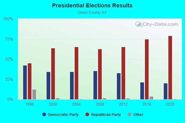
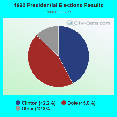
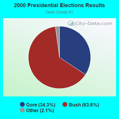

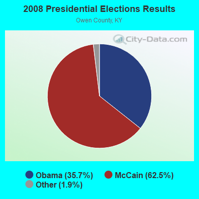
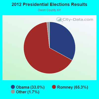
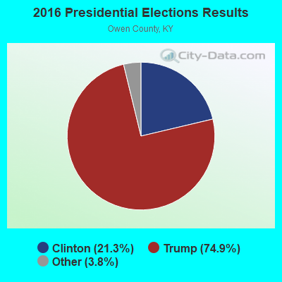
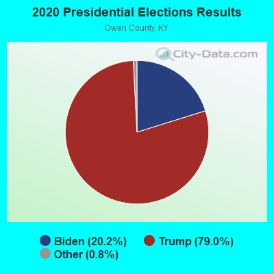
Graphs represent county-level data. Detailed 2008 Election Results
Religion statistics for New Liberty, KY (based on Owen County data)
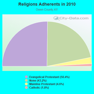

| Religion | Adherents | Congregations |
|---|---|---|
| Evangelical Protestant | 5,463 | 28 |
| Mainline Protestant | 495 | 6 |
| Catholic | 200 | 1 |
| Other | - | 1 |
| None | 4,683 | - |
Food Environment Statistics:
| Here: | 2.64 / 10,000 pop. |
| Kentucky: | 2.19 / 10,000 pop. |
| This county: | 4.39 / 10,000 pop. |
| Kentucky: | 4.36 / 10,000 pop. |
| Owen County: | 4.39 / 10,000 pop. |
| Kentucky: | 5.74 / 10,000 pop. |
| Owen County: | 10.8% |
| Kentucky: | 11.0% |
| This county: | 29.8% |
| Kentucky: | 30.0% |
| This county: | 18.6% |
| Kentucky: | 15.9% |
Strongest AM radio stations in New Liberty:
- WHAS (840 AM; 50 kW; LOUISVILLE, KY; Owner: CLEAR CHANNEL BROADCASTING LICENSES, INC.)
- WSAI (1530 AM; 50 kW; CINCINNATI, OH; Owner: JACOR BROADCASTING CORPORATION)
- WLW (700 AM; 50 kW; CINCINNATI, OH; Owner: JACOR BROADCASTING CORPORATION)
- WKRC (550 AM; 5 kW; CINCINNATI, OH; Owner: JACOR BROADCASTING CORPORATION)
- WBOB (1160 AM; 5 kW; FLORENCE, KY; Owner: CARON BROADCASTING, INC.)
- WTVN (610 AM; 50 kW; COLUMBUS, OH; Owner: CITICASTERS LICENSES, L.P.)
- WXRA (1580 AM; 10 kW; GEORGETOWN, KY; Owner: CITICASTERS LICENSES, L.P.)
- WVLK (590 AM; 5 kW; LEXINGTON, KY; Owner: CUMULUS LICENSING CORP.)
- WLAP (630 AM; 5 kW; LEXINGTON, KY; Owner: CITICASTERS LICENSES, L.P.)
- WIBC (1070 AM; 50 kW; INDIANAPOLIS, IN; Owner: EMMIS RADIO LICENSE CORPORATION)
- WKJK (1080 AM; 10 kW; LOUISVILLE, KY; Owner: CLEAR CHANNEL BROADCASTING LICENSES, INC.)
- WXXA (790 AM; 5 kW; LOUISVILLE, KY)
- WGTK (970 AM; 5 kW; LOUISVILLE, KY; Owner: SALEM MEDIA OF KENTUCKY, INC.)
Strongest FM radio stations in New Liberty:
- WNKR (106.5 FM; WILLIAMSTOWN, KY; Owner: GRANT COUNTY BROADCASTERS, INC)
- WKID (95.9 FM; VEVAY, IN; Owner: DIAL BROADCASTING INC)
- WSCH (99.3 FM; AURORA, IN; Owner: COLUMBUS RADIO, INC.)
- WIOK (107.5 FM; FALMOUTH, KY; Owner: HAMMOND BROADCASTING, INC.)
- WIKI (95.3 FM; CARROLLTON, KY; Owner: STAR MEDIA, INC.)
- WORX-FM (96.7 FM; MADISON, IN; Owner: DUBOIS COUNTY BROADCASTING, INC.)
- WEBN (102.7 FM; CINCINNATI, OH; Owner: JACOR BROADCASTING CORPORATION)
- WVMX (94.1 FM; CINCINNATI, OH; Owner: CITICASTERS LICENSES, L.P.)
- WGRR (103.5 FM; HAMILTON, OH; Owner: INFINITY RADIO OPERATIONS INC.)
- WUBE-FM (105.1 FM; CINCINNATI, OH; Owner: INFINITY RADIO OPERATIONS INC.)
- WOFX-FM (92.5 FM; CINCINNATI, OH; Owner: JACOR BROADCASTING CORPORATION)
- WGUC (90.9 FM; CINCINNATI, OH; Owner: CINCINNATI CLASSICAL PUBLIC RADIO, INC.)
- WKRQ (101.9 FM; CINCINNATI, OH; Owner: INFINITY RADIO OPERATIONS INC.)
- WKFS (107.1 FM; MILFORD, OH; Owner: JACOR BROADCASTING CORPORATION)
- WTSZ-FM (105.7 FM; EMINENCE, KY; Owner: METRO EAST CBC, INC.)
TV broadcast stations around New Liberty:
- WKON (Channel 52; OWENTON, KY; Owner: KENTUCKY AUTHORITY FOR EDUCATIONAL TV)
- WAVE (Channel 3; LOUISVILLE, KY; Owner: LIBCO, INC.)
- WLWT (Channel 5; CINCINNATI, OH; Owner: OHIO/OKLAHOMA HEARST-ARGYLE TV, INC)
- WCPO-TV (Channel 9; CINCINNATI, OH; Owner: SCRIPPS HOWARD BROADCASTING COMPANY)
- WXIX-TV (Channel 19; NEWPORT, KY; Owner: RAYCOM NATIONAL, INC.)
- W24BW (Channel 24; LOUISVILLE, KY; Owner: GREATER LOUISVILLE COMMUNICATIONS)
- WKRC-TV (Channel 12; CINCINNATI, OH; Owner: CITICASTERS CO.)
- WSTR-TV (Channel 64; CINCINNATI, OH; Owner: WSTR LICENSEE, INC.)
- WCET (Channel 48; CINCINNATI, OH; Owner: THE GREATER CINCINNATI TV EDUC'L. FOUNDATION)

New Liberty fatal accident list:
FCC Registered Antenna Towers:
3- Lisa M Minney, 7530 Highway 127 North (Lat: 38.622750 Lon: -84.848528), Type: 91.4, Overall height: 86.8 m, Registrant: Crown Castle Gt Company LLC, Regulatory.Department@crowncastle.Com, , Canon-sburg, Phone: (724) 416-2000
- Alice L Silverthorn, 7530 Highway 127 North (Lat: 38.622750 Lon: -84.848528), Type: 91.4, Overall height: 86.8 m, Registrant: Cellco Partnership, Carol.King@verizonwireless.Com, , Alpha-retta, Phone: (678) 339-4277
- Jennifer Flynn, 7530 Highway 127 North (Lat: 38.622750 Lon: -84.848528), Type: 91.4, Overall height: 86.8 m, Registrant: Verizon Wireless, Carol.King@verizonwireless.Com, , Alpha-retta, Phone: (678) 339-4277
FCC Registered Microwave Towers:
6- Owen County SWYD, Off Ky Hwy 36/227, 1 Mi E Of (Lat: 38.610333 Lon: -84.888000), Type: Tower, Structure height: 42.7 m, Overall height: 44.5 m, Call Sign: WQAM570,
Assigned Frequencies: 6765.00 MHz, 6775.00 MHz, Grant Date: 07/02/2004, Expiration Date: 07/02/2014, Cancellation Date: 04/04/2008, Certifier: Terry E Estes, Registrant: Utility Telecom Consulting Group, Inc., 1554 St. Paul Street, Denver, CO 80206, Phone: (303) 840-2878, Fax: (303) 840-1129, Email:
- Owen County Swyd, Ekpc Owen County Switchyard 1 Mi E Of New Liberty, Ky (Lat: 38.610333 Lon: -84.888000), Type: Gtower, Structure height: 42.7 m, Call Sign: WQQW773,
Assigned Frequencies: 6719.37 MHz, 6715.62 MHz, Grant Date: 03/18/2013, Expiration Date: 09/14/2013, Cancellation Date: 11/16/2013, Certifier: Jason Witt, Registrant: Greenberg Traurig, LLP, 2101 L Street, Nw, Suite 1000, Washington, DC 20037, Phone: (202) 331-3194, Fax: (202) 331-3101, Email:
- Owen County Swyd., Ekpc Owen County Switchyard, 1.0 Mile E Of (Lat: 38.610333 Lon: -84.888000), Type: Ltower, Structure height: 42.7 m, Call Sign: WQRS532,
Assigned Frequencies: 6795.00 MHz, 6815.00 MHz, Grant Date: 07/18/2023, Expiration Date: 07/18/2033, Certifier: Terry E Estes, Registrant: Utility Telecom Consulting Group, Inc., 9850 S Maryland Pkwy Ste A5-108, Las Vegas, NV 89183, Phone: (702) 340-1706, Email:
- New LIberty, 288 Ky 36 (Lat: 38.617639 Lon: -84.909944), Type: Ltower, Structure height: 18.3 m, Call Sign: WRHU202,
Assigned Frequencies: 19380.0 MHz, 19460.0 MHz, 19380.0 MHz, 19460.0 MHz, 19380.0 MHz, 19460.0 MHz, 19380.0 MHz, 19460.0 MHz, 19380.0 MHz, 19460.0 MHz... (+19 more), Grant Date: 06/18/2020, Expiration Date: 06/18/2030, Certifier: Tj Scott, Registrant: Micronet Communications, Inc., 812 Lexington Dr, Plano, TX 75075, Phone: (972) 422-7200, Email:
- Owen County Swyd, Ekpc Owen County Switchyard 1 Mi E Of (Lat: 38.610333 Lon: -84.888000), Type: Tower, Structure height: 42.7 m, Call Sign: KGI26,
Assigned Frequencies: 6719.37 MHz, 6715.62 MHz, Grant Date: 10/16/2002, Expiration Date: 10/29/2012, Cancellation Date: 04/27/2013, Registrant: Utility Telecom Consulting Group, Inc., 1554 St. Paul Street, Denver, CO 80206, Phone: (303) 840-1041, Fax: (303) 840-1028, Email:
- WHEATLEY, 1.5 Mi N Of (Lat: 38.607278 Lon: -84.936056), Overall height: 98.5 m, Call Sign: KJJ24,
Assigned Frequencies: 6034.20 MHz, 6034.20 MHz, 5945.20 MHz, 6004.50 MHz, 6152.80 MHz, 6152.80 MHz, 6063.80 MHz, 6123.10 MHz, Grant Date: 04/11/1991, Expiration Date: 02/01/2001, Cancellation Date: 05/06/2001, Registrant: Specialty Antenna Site Resources, Inc, Cedar Crest, NM 87008
FAA Registered Aircraft:
1- Aircraft: CESSNA 172E (Category: Land, Seats: 4, Weight: Up to 12,499 Pounds, Speed: 105 mph), Engine: CONT MOTOR 0-300 SER (145 HP) (Reciprocating)
N-Number: 7757U, N7757U, N-7757U, Serial Number: 17251757, Year manufactured: 1964, Airworthiness Date: 08/14/1964, Certificate Issue Date: 06/22/2017
Registrant (Individual): Delmar Ii Stockdale, 940 Highway 227 N, New Liberty, KY 40355

- 50.4%Electricity
- 32.9%Bottled, tank, or LP gas
- 9.0%Fuel oil, kerosene, etc.
- 6.2%Wood
- 1.0%Other fuel
- 0.6%Utility gas

- 33.2%Bottled, tank, or LP gas
- 29.5%Electricity
- 28.6%Fuel oil, kerosene, etc.
- 6.4%Wood
- 2.3%Utility gas
New Liberty compared to Kentucky state average:
- Unemployed percentage significantly below state average.
- Black race population percentage significantly below state average.
- Hispanic race population percentage significantly below state average.
- Median age below state average.
- Foreign-born population percentage significantly below state average.
- Renting percentage below state average.
- Length of stay since moving in significantly above state average.
- Number of rooms per house significantly below state average.
- House age significantly below state average.
- Percentage of population with a bachelor's degree or higher below state average.