Muldraugh, Kentucky
Submit your own pictures of this city and show them to the world
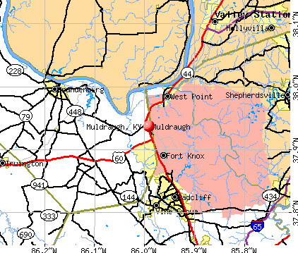
- OSM Map
- General Map
- Google Map
- MSN Map
Population change since 2000: -21.5%
| Males: 564 | |
| Females: 455 |
| Median resident age: | 39.9 years |
| Kentucky median age: | 39.4 years |
Zip codes: 40155.
| Muldraugh: | $48,684 |
| KY: | $59,341 |
Estimated per capita income in 2022: $22,206 (it was $13,318 in 2000)
Muldraugh city income, earnings, and wages data
Estimated median house or condo value in 2022: $74,971 (it was $39,700 in 2000)
| Muldraugh: | $74,971 |
| KY: | $196,300 |
Mean prices in 2022: all housing units: $132,115; detached houses: $127,333; mobile homes: $130,525
Median gross rent in 2022: $831.
(15.4% for White Non-Hispanic residents, 40.5% for Black residents, 17.2% for Hispanic or Latino residents, 7.1% for two or more races residents)
Detailed information about poverty and poor residents in Muldraugh, KY
Compare current foreclosures near Muldraugh, KY:
| Photo | Address | Area | Beds / Baths | Price | Details |
|---|---|---|---|---|---|

|
#1
Walker Rd
Muldraugh, KY 40155
|
- sq. feet
|
1 baths 3 beds |
show details | |

|
#2
Wilson St Apt 17
Muldraugh, KY 40155
|
- sq. feet
|
- baths - beds |
show details | |

|
#3
Creek Bed St
Muldraugh, KY 40155
|
- sq. feet
|
- baths - beds |
show details | |

|
#4
Chillicoop Rd
Shepherdsville, KY 40165
|
- sq. feet
|
2 baths 4 beds |
$99,900
|
show details |

|
#5
E Spring St
Radcliff, KY 40160
|
891 sq. feet
|
1 baths 1 beds |
show details | |

|
#6
Welch Dr
Louisville, KY 40272
|
740 sq. feet
|
1 baths 2 beds |
show details | |

|
#7
Jessamine Ln
Louisville, KY 40258
|
1,107 sq. feet
|
1 baths 3 beds |
show details | |

|
#8
Berkshire Ave
Rineyville, KY 40162
|
- sq. feet
|
2 baths 3 beds |
show details | |

|
#9
Dogwood Dr
Radcliff, KY 40160
|
1,520 sq. feet
|
1 baths 3 beds |
show details | |

|
#10
Dorset Rd
Louisville, KY 40214
|
1,125 sq. feet
|
1 baths 4 beds |
show details |
| Photo | Address | Area | Beds / Baths | Price | Details |
|---|---|---|---|---|---|

|
#11
Tim Ct
Radcliff, KY 40160
|
1,764 sq. feet
|
2 baths 3 beds |
show details | |

|
#12
Boxwood Ct
Rineyville, KY 40162
|
1,842 sq. feet
|
2 baths 4 beds |
show details | |

|
#13
S Preston Hwy
Lebanon Junction, KY 40150
|
1,440 sq. feet
|
1 baths 3 beds |
show details | |

|
#14
Wintergreen Dr
Radcliff, KY 40160
|
1,537 sq. feet
|
2 baths 3 beds |
show details | |

|
#15
Wintergreen Dr
Radcliff, KY 40160
|
1,716 sq. feet
|
2 baths 3 beds |
show details | |

|
#16
Andra Dr
Radcliff, KY 40160
|
1,208 sq. feet
|
2 baths 3 beds |
show details | |

|
#17
Hensley Rd
Shepherdsville, KY 40165
|
1,100 sq. feet
|
2 baths 3 beds |
show details | |

|
#18
Madison Rae Blvd
Shepherdsville, KY 40165
|
1,268 sq. feet
|
2 baths 3 beds |
show details | |

|
#19
Dogwood Run
Shepherdsville, KY 40165
|
1,188 sq. feet
|
2 baths 3 beds |
show details | |

|
#20
David Ct
Radcliff, KY 40160
|
1,485 sq. feet
|
2 baths 3 beds |
show details |
| Photo | Address | Area | Beds / Baths | Price | Details |
|---|---|---|---|---|---|

|
#21
Depauw Church Rd SE
Elizabeth, IN 47117
|
1,462 sq. feet
|
1 baths 2 beds |
show details | |

|
#22
Amber Ct
Radcliff, KY 40160
|
1,188 sq. feet
|
2 baths 3 beds |
show details | |

|
#23
Pearman Ave
Radcliff, KY 40160
|
1,161 sq. feet
|
1 baths 3 beds |
show details | |

|
#24
Pearman Ave
Radcliff, KY 40160
|
2,200 sq. feet
|
2 baths 3 beds |
show details | |

|
#25
Lavender Ct
Radcliff, KY 40160
|
1,208 sq. feet
|
2 baths 3 beds |
show details | |

|
#26
Manley Ave
Vine Grove, KY 40175
|
864 sq. feet
|
1 baths 3 beds |
show details | |

|
#27
Cedarcrest Dr
Vine Grove, KY 40175
|
936 sq. feet
|
1 baths 3 beds |
show details | |

|
#28
Haley Ave
Shepherdsville, KY 40165
|
1,326 sq. feet
|
2 baths 3 beds |
show details | |

|
#29
Tecumseh Dr
Shepherdsville, KY 40165
|
1,122 sq. feet
|
2 baths 3 beds |
show details | |

|
#30
S Old Highway 11 SE
Laconia, IN 47135
|
1,768 sq. feet
|
1 baths 3 beds |
show details |
| Photo | Address | Area | Beds / Baths | Price | Details |
|---|---|---|---|---|---|

|
#31
Cabernet Dr
Vine Grove, KY 40175
|
2,598 sq. feet
|
2 baths 3 beds |
show details | |

|
#32
Carolyn St
Radcliff, KY 40160
|
1,809 sq. feet
|
2 baths 4 beds |
show details | |

|
#33
Fairview Ave
Radcliff, KY 40160
|
1,204 sq. feet
|
1 baths 3 beds |
show details | |

|
#34
Lory Ln
Shepherdsville, KY 40165
|
1,066 sq. feet
|
1 baths 3 beds |
show details | |

|
#35
S Peak Ave
Shepherdsville, KY 40165
|
1,659 sq. feet
|
2 baths 3 beds |
show details | |

|
#36
Beechwood Ave
Shepherdsville, KY 40165
|
1,403 sq. feet
|
3 baths 2 beds |
show details | |

|
#37
Kentucky Cir
Radcliff, KY 40160
|
1,349 sq. feet
|
2 baths 3 beds |
show details | |

|
#38
Saint Clare St
Elizabethtown, KY 42701
|
1,296 sq. feet
|
1 baths 2 beds |
show details | |

|
#39
Berkley Ct
Radcliff, KY 40160
|
1,100 sq. feet
|
1 baths 3 beds |
show details | |

|
#40
W Crocus Dr
Radcliff, KY 40160
|
1,428 sq. feet
|
1 baths 3 beds |
show details |
| Photo | Address | Area | Beds / Baths | Price | Details |
|---|---|---|---|---|---|

|
#41
Indiana Trl
Radcliff, KY 40160
|
1,598 sq. feet
|
2 baths 3 beds |
show details | |

|
#42
Atcher St
Radcliff, KY 40160
|
1,331 sq. feet
|
1 baths 3 beds |
show details | |

|
#43
Battle Training Rd
Elizabethtown, KY 42701
|
1,510 sq. feet
|
2 baths 3 beds |
show details | |

|
#44
Woodsway Dr
Elizabethtown, KY 42701
|
1,742 sq. feet
|
2 baths 3 beds |
show details | |

|
#45
W Tuscany Ct
Radcliff, KY 40160
|
1,488 sq. feet
|
2 baths 3 beds |
show details | |

|
#46
Chestnut St
Elizabethtown, KY 42701
|
2,530 sq. feet
|
3 baths 4 beds |
show details | |

|
#47
Jade Dr
Shepherdsville, KY 40165
|
1,314 sq. feet
|
2 baths 3 beds |
show details | |

|
#48
Amanda Jo Dr
Elizabethtown, KY 42701
|
1,720 sq. feet
|
2 baths 3 beds |
show details | |

|
#49
Amanda Jo Dr
Elizabethtown, KY 42701
|
1,890 sq. feet
|
2 baths 3 beds |
show details | |

|
Check over 1 million property listings on Foreclosure.com!
|
browse all offers | |||


- 1,05786.4%White alone
- 907.4%Hispanic
- 383.1%Two or more races
- 352.9%Black alone
- 20.2%American Indian alone

Races in Muldraugh detailed stats: ancestries, foreign born residents, place of birth
According to our research of Kentucky and other state lists, there were 5 registered sex offenders living in Muldraugh, Kentucky as of May 22, 2024.
The ratio of all residents to sex offenders in Muldraugh is 249 to 1.
Type |
2009 |
2010 |
2011 |
2012 |
2013 |
2014 |
2015 |
2016 |
2017 |
2018 |
2019 |
2020 |
2021 |
2022 |
|---|---|---|---|---|---|---|---|---|---|---|---|---|---|---|
| Murders (per 100,000) | 0 (0.0) | 0 (0.0) | 0 (0.0) | 0 (0.0) | 0 (0.0) | 0 (0.0) | 0 (0.0) | 0 (0.0) | 0 (0.0) | 0 (0.0) | 0 (0.0) | 0 (0.0) | 0 (0.0) | 0 (0.0) |
| Rapes (per 100,000) | 0 (0.0) | 0 (0.0) | 0 (0.0) | 0 (0.0) | 2 (183.2) | 0 (0.0) | 0 (0.0) | 0 (0.0) | 0 (0.0) | 0 (0.0) | 0 (0.0) | 0 (0.0) | 1 (101.5) | 0 (0.0) |
| Robberies (per 100,000) | 0 (0.0) | 0 (0.0) | 0 (0.0) | 1 (101.9) | 0 (0.0) | 0 (0.0) | 0 (0.0) | 1 (100.6) | 0 (0.0) | 1 (101.6) | 2 (200.0) | 0 (0.0) | 0 (0.0) | 0 (0.0) |
| Assaults (per 100,000) | 0 (0.0) | 0 (0.0) | 1 (104.8) | 1 (101.9) | 1 (91.6) | 2 (186.9) | 3 (282.8) | 0 (0.0) | 0 (0.0) | 0 (0.0) | 0 (0.0) | 3 (302.7) | 0 (0.0) | 0 (0.0) |
| Burglaries (per 100,000) | 0 (0.0) | 2 (211.2) | 4 (419.3) | 9 (917.4) | 5 (457.9) | 3 (280.4) | 0 (0.0) | 3 (301.8) | 2 (201.0) | 0 (0.0) | 7 (700.0) | 7 (706.4) | 3 (304.6) | 3 (291.8) |
| Thefts (per 100,000) | 1 (82.4) | 2 (211.2) | 16 (1,677) | 7 (713.6) | 14 (1,282) | 9 (841.1) | 8 (754.0) | 11 (1,107) | 13 (1,307) | 12 (1,220) | 11 (1,100) | 12 (1,211) | 7 (710.7) | 5 (486.4) |
| Auto thefts (per 100,000) | 0 (0.0) | 0 (0.0) | 2 (209.6) | 1 (101.9) | 3 (274.7) | 4 (373.8) | 4 (377.0) | 6 (603.6) | 1 (100.5) | 2 (203.3) | 6 (600.0) | 10 (1,009) | 5 (507.6) | 7 (680.9) |
| Arson (per 100,000) | 0 (0.0) | 0 (0.0) | 0 (0.0) | 0 (0.0) | 0 (0.0) | 0 (0.0) | 0 (0.0) | 0 (0.0) | 1 (100.5) | 0 (0.0) | 0 (0.0) | 0 (0.0) | 0 (0.0) | 0 (0.0) |
| City-Data.com crime index | 3.3 | 23.2 | 134.2 | 151.9 | 270.1 | 120.6 | 116.9 | 143.9 | 74.4 | 95.5 | 201.0 | 239.2 | 171.6 | 94.4 |
The City-Data.com crime index weighs serious crimes and violent crimes more heavily. Higher means more crime, U.S. average is 246.1. It adjusts for the number of visitors and daily workers commuting into cities.

Crime rate in Muldraugh detailed stats: murders, rapes, robberies, assaults, burglaries, thefts, arson
Full-time law enforcement employees in 2021, including police officers: 3 (3 officers - 3 male; 0 female).
| Officers per 1,000 residents here: | 3.05 |
| Kentucky average: | 1.89 |
 Recent articles from our blog. Our writers, many of them Ph.D. graduates or candidates, create easy-to-read articles on a wide variety of topics.


Latest news from Muldraugh, KY collected exclusively by city-data.com from local newspapers, TV, and radio stations
Ancestries: American (24.1%), European (4.9%), Polish (4.9%), German (3.7%), Italian (3.4%), English (2.7%).
Current Local Time: EST time zone
Incorporated on 04/29/1952
Elevation: 720 feet
Land area: 0.57 square miles.
Population density: 1,778 people per square mile (low).
8 residents are foreign born
| This city: | 0.7% |
| Kentucky: | 4.1% |
Median real estate property taxes paid for housing units with mortgages in 2022: $817 (0.8%)
Median real estate property taxes paid for housing units with no mortgage in 2022: $357 (0.5%)
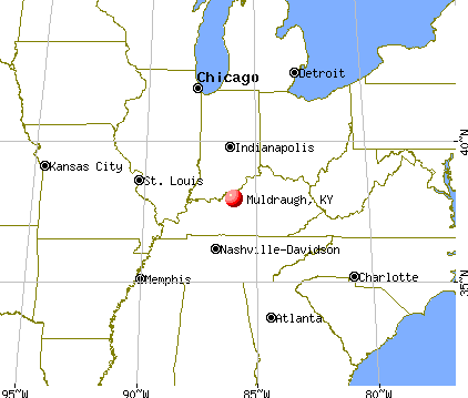
Nearest city with pop. 50,000+: Louisville, KY  (24.1 miles , pop. 256,231).
Nearest city with pop. 1,000,000+: Chicago, IL (284.5 miles , pop. 2,896,016).
Nearest cities:
), ), ), Latitude: 37.94 N, Longitude: 85.99 W


Single-family new house construction building permits:
- 2001: 3 buildings, average cost: $117,400
- 2000: 3 buildings, average cost: $49,700
| Here: | 4.1% |
| Kentucky: | 3.8% |

- Construction (19.6%)
- Accommodation & food services (7.4%)
- Public administration (7.0%)
- Repair & maintenance (3.3%)
- Health care (3.3%)
- Truck transportation (3.3%)
- Other transportation, support activities, couriers (3.0%)

- Construction (30.2%)
- Public administration (6.6%)
- Repair & maintenance (5.2%)
- Truck transportation (5.2%)
- Administrative & support & waste management services (3.6%)
- Professional, scientific, technical services (3.0%)
- Utilities (2.6%)

- Accommodation & food services (14.8%)
- Public administration (7.6%)
- Health care (6.8%)
- Finance & insurance (6.4%)
- Construction (5.9%)
- Food & beverage stores (4.2%)
- Social assistance (4.2%)

- Cashiers (6.8%)
- Other production occupations, including supervisors (6.3%)
- Carpenters (5.7%)
- Laborers and material movers, hand (5.2%)
- Driver/sales workers and truck drivers (5.0%)
- Material recording, scheduling, dispatching, and distributing workers (4.8%)
- Other office and administrative support workers, including supervisors (4.8%)

- Carpenters (9.2%)
- Driver/sales workers and truck drivers (8.2%)
- Construction traders workers except carpenters, electricians, painters, plumbers, and construction laborers (7.5%)
- Other production occupations, including supervisors (7.2%)
- Construction laborers (4.9%)
- Laborers and material movers, hand (4.6%)
- Electricians (4.3%)

- Cashiers (13.1%)
- Other office and administrative support workers, including supervisors (10.2%)
- Laborers and material movers, hand (5.9%)
- Material recording, scheduling, dispatching, and distributing workers (5.5%)
- Other production occupations, including supervisors (5.1%)
- Information and record clerks, except customer service representatives (4.7%)
- Child care workers (4.2%)
Average climate in Muldraugh, Kentucky
Based on data reported by over 4,000 weather stations


|
|

(lower is better)

Air Quality Index (AQI) level in 2022 was 78.6. This is about average.
| City: | 78.6 |
| U.S.: | 72.6 |

Carbon Monoxide (CO) [ppm] level in 2022 was 0.325. This is worse than average. Closest monitor was 10.0 miles away from the city center.
| City: | 0.325 |
| U.S.: | 0.251 |

Nitrogen Dioxide (NO2) [ppb] level in 2022 was 14.1. This is significantly worse than average. Closest monitor was 10.0 miles away from the city center.
| City: | 14.1 |
| U.S.: | 5.1 |

Sulfur Dioxide (SO2) [ppb] level in 2022 was 0.489. This is significantly better than average. Closest monitor was 10.0 miles away from the city center.
| City: | 0.489 |
| U.S.: | 1.515 |

Ozone [ppb] level in 2022 was 28.3. This is about average. Closest monitor was 10.0 miles away from the city center.
| City: | 28.3 |
| U.S.: | 33.3 |

Particulate Matter (PM10) [µg/m3] level in 2022 was 21.0. This is about average. Closest monitor was 10.0 miles away from the city center.
| City: | 21.0 |
| U.S.: | 19.2 |

Particulate Matter (PM2.5) [µg/m3] level in 2022 was 9.44. This is about average. Closest monitor was 10.0 miles away from the city center.
| City: | 9.44 |
| U.S.: | 8.11 |
Tornado activity:
Muldraugh-area historical tornado activity is slightly above Kentucky state average. It is 58% greater than the overall U.S. average.
On 4/3/1974, a category F5 (max. wind speeds 261-318 mph) tornado 9.8 miles away from the Muldraugh city center killed 31 people and injured 270 people and caused between $500,000 and $5,000,000 in damages.
On 4/3/1974, a category F4 (max. wind speeds 207-260 mph) tornado 15.8 miles away from the city center killed 3 people and injured 81 people and caused between $50,000 and $500,000 in damages.
Earthquake activity:
Muldraugh-area historical earthquake activity is significantly above Kentucky state average. It is 131% greater than the overall U.S. average.On 4/18/2008 at 09:36:59, a magnitude 5.4 (5.1 MB, 4.8 MS, 5.4 MW, 5.2 MW, Class: Moderate, Intensity: VI - VII) earthquake occurred 109.0 miles away from Muldraugh center
On 4/18/2008 at 09:36:59, a magnitude 5.2 (5.2 MW, Depth: 8.9 mi) earthquake occurred 109.0 miles away from Muldraugh center
On 7/27/1980 at 18:52:21, a magnitude 5.2 (5.1 MB, 4.7 MS, 5.0 UK, 5.2 UK) earthquake occurred 113.1 miles away from Muldraugh center
On 6/18/2002 at 17:37:15, a magnitude 5.0 (4.3 MB, 4.6 MW, 5.0 LG) earthquake occurred 97.6 miles away from the city center
On 6/10/1987 at 23:48:54, a magnitude 5.1 (4.9 MB, 4.4 MS, 4.6 MS, 5.1 LG) earthquake occurred 119.5 miles away from Muldraugh center
On 4/18/2008 at 15:14:16, a magnitude 4.8 (4.5 MB, 4.8 MW, 4.6 MW, Class: Light, Intensity: IV - V) earthquake occurred 107.5 miles away from Muldraugh center
Magnitude types: regional Lg-wave magnitude (LG), body-wave magnitude (MB), surface-wave magnitude (MS), moment magnitude (MW)
Natural disasters:
The number of natural disasters in Meade County (15) is near the US average (15).Major Disasters (Presidential) Declared: 12
Emergencies Declared: 2
Causes of natural disasters: Storms: 8, Floods: 7, Tornadoes: 6, Winter Storms: 3, Winds: 2, Blizzard: 1, Hurricane: 1, Tropical Depression: 1, Other: 1 (Note: some incidents may be assigned to more than one category).

Hospitals and medical centers near Muldraugh:
- DAVITA - RADCLIFF DIALYSIS (Dialysis Facility, about 8 miles away; RADCLIFF, KY)
- NORTH HARDIN HEALTH AND REHABILITATION CENTER (Nursing Home, about 9 miles away; RADCLIFF, KY)
- MEDCO CENTER OF BRANDENBURG (Nursing Home, about 11 miles away; BRANDENBURG, KY)
- LINCOLN TRAIL BEHAVIORAL HEALTH SYSTEM (Hospital, about 12 miles away; RADCLIFF, KY)
- FMC - SOUTHWEST (Dialysis Facility, about 15 miles away; VALLEY STATION, KY)
- PARK TERRACE HEALTH CAMPUS (Nursing Home, about 15 miles away; LOUISVILLE, KY)
- AMEDISYS HOME HEALTH OF LOUISVILLE SOUTH (Home Health Center, about 15 miles away; LOUISVILLE, KY)
Colleges/universities with over 2000 students nearest to Muldraugh:
- Elizabethtown Community and Technical College (about 18 miles; Elizabethtown, KY; Full-time enrollment: 3,762)
- University of Louisville (about 24 miles; Louisville, KY; FT enrollment: 16,640)
- Bellarmine University (about 25 miles; Louisville, KY; FT enrollment: 3,180)
- Jefferson Community and Technical College (about 26 miles; Louisville, KY; FT enrollment: 7,950)
- Sullivan University (about 26 miles; Louisville, KY; FT enrollment: 5,129)
- The Southern Baptist Theological Seminary (about 28 miles; Louisville, KY; FT enrollment: 2,360)
- Indiana University-Southeast (about 30 miles; New Albany, IN; FT enrollment: 5,050)
Points of interest:
Notable location: Muldraugh Fire Department (A). Display/hide its location on the map
Hotel: Travelers Motel (404 South Dixie Highway).
Drinking water stations with addresses in Muldraugh that have no violations reported:
- MULDRAUGH WATER DEPARTMENT (Population served: 1,262, Primary Water Source Type: Purch surface water)
| This city: | 2.3 people |
| Kentucky: | 2.5 people |
| This city: | 53.1% |
| Whole state: | 66.9% |
| This city: | 10.3% |
| Whole state: | 6.4% |
Likely homosexual households (counted as self-reported same-sex unmarried-partner households)
- Lesbian couples: 1.0% of all households
- Gay men: 0.5% of all households
Banks with branches in Muldraugh (2011 data):
- Meade County Bank: Muldraugh Branch at 104 North Dixie, branch established on 1986/01/02. Info updated 2006/11/03: Bank assets: $148.8 mil, Deposits: $133.4 mil, headquarters in Brandenburg, KY, positive income, Mortgage Lending Specialization, 3 total offices, Holding Company: Meade Bancorp, Inc.
For population 15 years and over in Muldraugh:

- Never married: 46.5%
- Now married: 25.2%
- Separated: 2.0%
- Widowed: 4.8%
- Divorced: 21.4%
For population 25 years and over in Muldraugh:
- High school or higher: 91.6%
- Bachelor's degree or higher: 6.1%
- Graduate or professional degree: 1.8%
- Unemployed: 14.7%
- Mean travel time to work (commute): 28.5 minutes


| Here: | 5.0 |
| Kentucky average: | 11.7 |
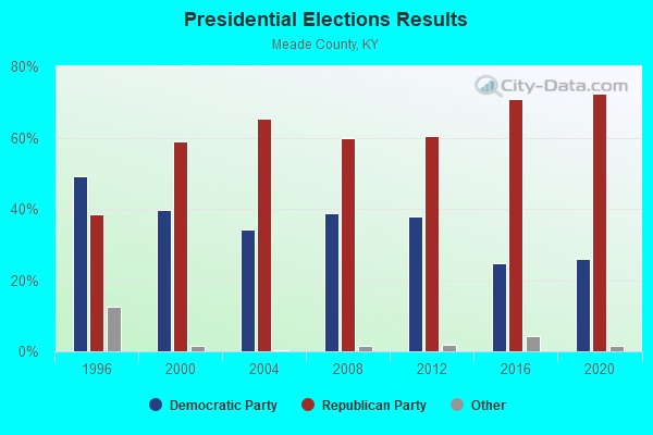
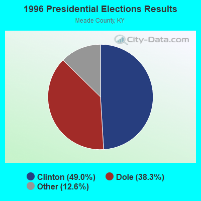
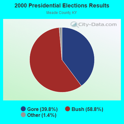
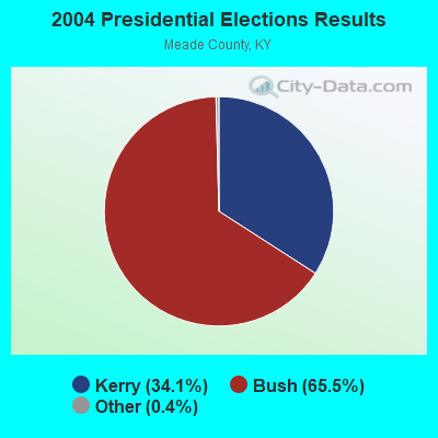
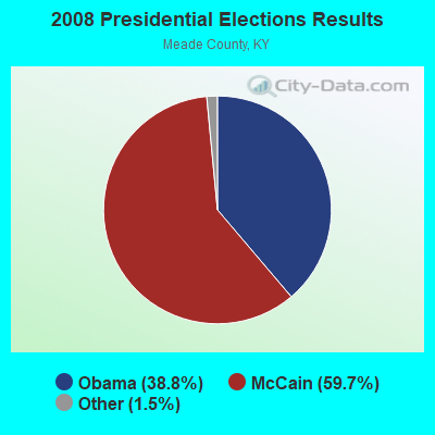
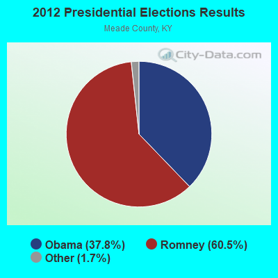
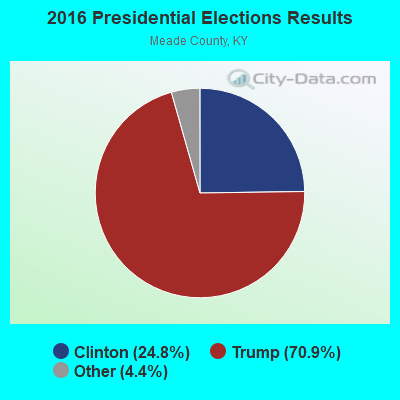
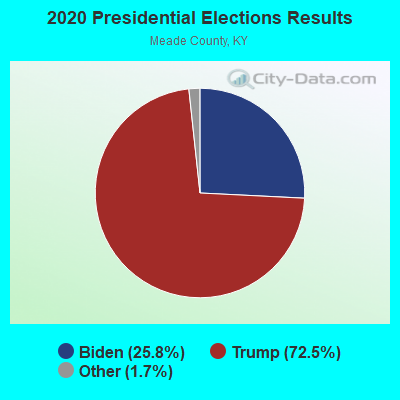
Graphs represent county-level data. Detailed 2008 Election Results
Religion statistics for Muldraugh, KY (based on Meade County data)
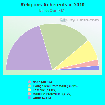
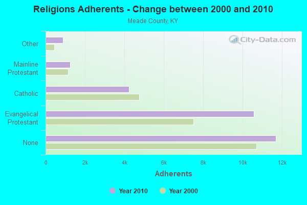
| Religion | Adherents | Congregations |
|---|---|---|
| Evangelical Protestant | 10,566 | 29 |
| Catholic | 4,227 | 4 |
| Mainline Protestant | 1,244 | 5 |
| Other | 877 | 1 |
| None | 11,688 | - |
Food Environment Statistics:
| Meade County: | 1.10 / 10,000 pop. |
| State: | 2.19 / 10,000 pop. |
| Meade County: | 0.37 / 10,000 pop. |
| State: | 0.74 / 10,000 pop. |
| Meade County: | 5.51 / 10,000 pop. |
| Kentucky: | 4.36 / 10,000 pop. |
| This county: | 2.57 / 10,000 pop. |
| Kentucky: | 5.74 / 10,000 pop. |
| Meade County: | 11.1% |
| Kentucky: | 11.0% |
| Meade County: | 33.0% |
| Kentucky: | 30.0% |
| This county: | 13.5% |
| Kentucky: | 15.9% |
Health and Nutrition:
| Muldraugh: | 53.2% |
| Kentucky: | 49.9% |
| Muldraugh: | 56.3% |
| State: | 47.0% |
| Muldraugh: | 27.8 |
| Kentucky: | 28.6 |
| Muldraugh: | 21.2% |
| Kentucky: | 21.0% |
| Muldraugh: | 8.2% |
| Kentucky: | 10.1% |
| Here: | 7.0 |
| Kentucky: | 6.8 |
| Muldraugh: | 30.6% |
| State: | 33.8% |
| Muldraugh: | 63.0% |
| Kentucky: | 56.8% |
| This city: | 83.7% |
| Kentucky: | 78.9% |
More about Health and Nutrition of Muldraugh, KY Residents
| Local government employment and payroll (March 2022) | |||||
| Function | Full-time employees | Monthly full-time payroll | Average yearly full-time wage | Part-time employees | Monthly part-time payroll |
|---|---|---|---|---|---|
| Police Protection - Officers | 4 | $14,134 | $42,402 | 0 | $0 |
| Financial Administration | 2 | $6,478 | $38,868 | 0 | $0 |
| Water Supply | 1 | $5,603 | $67,236 | 0 | $0 |
| Other Government Administration | 0 | $0 | 7 | $4,630 | |
| Streets and Highways | 0 | $0 | 1 | $1,405 | |
| Totals for Government | 7 | $26,214 | $44,938 | 8 | $6,035 |
Muldraugh government finances - Expenditure in 2018 (per resident):
- Current Operations - Water Utilities: $517,000 ($507.36)
Central Staff Services: $190,000 ($186.46)
Police Protection: $172,000 ($168.79)
Solid Waste Management: $69,000 ($67.71)
Local Fire Protection: $27,000 ($26.50)
Parks and Recreation: $9,000 ($8.83)
Regular Highways: $8,000 ($7.85)
Public Welfare - Other: $4,000 ($3.93)
- General - Interest on Debt: $14,000 ($13.74)
- Other Capital Outlay - Police Protection: $31,000 ($30.42)
Central Staff Services: $9,000 ($8.83)
Local Fire Protection: $5,000 ($4.91)
Parks and Recreation: $5,000 ($4.91)
- Total Salaries and Wages: $324,000 ($317.96)
- Water Utilities - Interest on Debt: $4,000 ($3.93)
Muldraugh government finances - Revenue in 2018 (per resident):
- Charges - Sewerage: $240,000 ($235.53)
Solid Waste Management: $132,000 ($129.54)
Other: $92,000 ($90.28)
Parks and Recreation: $10,000 ($9.81)
- Local Intergovernmental - Other: $8,000 ($7.85)
Health and Hospitals: $1,000 ($0.98)
- Miscellaneous - Rents: $38,000 ($37.29)
Sale of Property: $10,000 ($9.81)
- Revenue - Water Utilities: $171,000 ($167.81)
- State Intergovernmental - Other: $30,000 ($29.44)
Highways: $18,000 ($17.66)
- Tax - Insurance Premiums Sales: $138,000 ($135.43)
Individual Income: $92,000 ($90.28)
Property: $65,000 ($63.79)
Corporation Net Income: $57,000 ($55.94)
Public Utilities Sales: $37,000 ($36.31)
Muldraugh government finances - Debt in 2018 (per resident):
- Long Term Debt - Beginning Outstanding - Unspecified Public Purpose: $526,000 ($516.19)
Outstanding Unspecified Public Purpose: $467,000 ($458.29)
Retired Unspecified Public Purpose: $58,000 ($56.92)
Muldraugh government finances - Cash and Securities in 2018 (per resident):
- Other Funds - Cash and Securities: $285,000 ($279.69)
- Sinking Funds - Cash and Securities: $19,000 ($18.65)
10.89% of this county's 2021 resident taxpayers lived in other counties in 2020 ($55,543 average adjusted gross income)
| Here: | 10.89% |
| Kentucky average: | 7.04% |
0.34% of residents moved from foreign countries ($2,243 average AGI)
Meade County: 0.34% Kentucky average: 0.02%
Top counties from which taxpayers relocated into this county between 2020 and 2021:
| from Hardin County, KY | |
| from Jefferson County, KY | |
| from Breckinridge County, KY |
10.44% of this county's 2020 resident taxpayers moved to other counties in 2021 ($52,951 average adjusted gross income)
| Here: | 10.44% |
| Kentucky average: | 6.89% |
0.22% of residents moved to foreign countries ($1,551 average AGI)
Meade County: 0.22% Kentucky average: 0.01%
Top counties to which taxpayers relocated from this county between 2020 and 2021:
| to Hardin County, KY | |
| to Jefferson County, KY | |
| to Breckinridge County, KY |
Businesses in Muldraugh, KY
- Dairy Queen: 1
- Pizza Hut: 1
- U-Haul: 1
Strongest AM radio stations in Muldraugh:
- WHAS (840 AM; 50 kW; LOUISVILLE, KY; Owner: CLEAR CHANNEL BROADCASTING LICENSES, INC.)
- WKJK (1080 AM; 10 kW; LOUISVILLE, KY; Owner: CLEAR CHANNEL BROADCASTING LICENSES, INC.)
- WXXA (790 AM; 5 kW; LOUISVILLE, KY)
- WGTK (970 AM; 5 kW; LOUISVILLE, KY; Owner: SALEM MEDIA OF KENTUCKY, INC.)
- WLCR (1470 AM; daytime; 2 kW; SHEPHERDSVILLE, KY; Owner: LCR PARTNERS, L.P.)
- WLW (700 AM; 50 kW; CINCINNATI, OH; Owner: JACOR BROADCASTING CORPORATION)
- WSM (650 AM; 50 kW; NASHVILLE, TN; Owner: GAYLORD ENTERTAINMENT COMPANY)
- WDRD (680 AM; 1 kW; NEWBURG, KY; Owner: ABC, INC.)
- WLOU (1350 AM; 2 kW; LOUISVILLE, KY; Owner: MORTENSON BROADCASTING CO., INC.)
- WSAI (1530 AM; 50 kW; CINCINNATI, OH; Owner: JACOR BROADCASTING CORPORATION)
- WAMB (1160 AM; 50 kW; DONELSON, TN; Owner: GREAT SOUTHERN BROADCASTING COMPANY, INC.)
- WKDA (1200 AM; 50 kW; NASHVILLE, TN; Owner: RADIO NASHVILLE, INC.)
- WMMG (1140 AM; daytime; 0 kW; BRANDENBURG, KY; Owner: MEADE COUNTY COMMUNICATIONS, INC.)
Strongest FM radio stations in Muldraugh:
- WASE (103.5 FM; RADCLIFF, KY; Owner: W & B BROADCASTING, INC.)
- WRVI (105.9 FM; VALLEY STATION, KY; Owner: SALEM MEDIA OF KENTUCKY, INC.)
- WJIE-FM (88.5 FM; OKOLONA, KY; Owner: EVANGEL SCHOOLS, INC.)
- WQMF (95.7 FM; JEFFERSONVILLE, IN; Owner: CLEAR CHANNEL BROADCASTING LICENSES, INC.)
- WKUE (90.9 FM; ELIZABETHTOWN, KY; Owner: WESTERN KENTUCKY UNIVERSITY)
- WLVK (105.5 FM; FORT KNOX, KY; Owner: BIG CAT BROADCASTING, INC.)
- WQXE (98.3 FM; ELIZABETHTOWN, KY; Owner: SKYTOWER COMMUNICATIONS-E'TOWN, INC.)
- WMMG-FM (93.5 FM; BRANDENBURG, KY; Owner: MEADE COUNTY COMMUNICATIONS, INC.)
- WAMZ (97.5 FM; LOUISVILLE, KY; Owner: CLEAR CHANNEL BROADCASTING LICENSES, INC.)
- WULF (94.3 FM; HARDINSBURG, KY; Owner: SKYTOWER COMMUNICATIONS - 94.3, LLC)
- WSFR (107.7 FM; CORYDON, IN; Owner: CXR HOLDINGS, INC.)
- WLRS (105.1 FM; SHEPHERDSVILLE, KY; Owner: BLUE CHIP BROADCASTING LICENSES II, LTD.)
- WFPL (89.3 FM; LOUISVILLE, KY; Owner: KENTUCKY PUBLIC RADIO, INC.)
- WRZI (101.5 FM; VINE GROVE, KY; Owner: ELIZABETHTOWN CBC, INC.)
- WFPK (91.9 FM; LOUISVILLE, KY; Owner: KENTUCKY PUBLIC RADIO, INC.)
- WUOL-FM (90.5 FM; LOUISVILLE, KY; Owner: KENTUCKY PUBLIC RADIO, INC.)
- WTHX (107.3 FM; LEBANON JUNCTION, KY; Owner: ELIZABETHTOWN CBC, INC.)
- WDJX (99.7 FM; LOUISVILLE, KY; Owner: BLUE CHIP BROADCASTING LICENSES II, LTD.)
- W284AD (104.7 FM; NEW ALBANY, IN; Owner: LIFETALK RADIO, INC.)
- WPTI (103.9 FM; LOUISVILLE, KY; Owner: CXR HOLDINGS, INC.)
TV broadcast stations around Muldraugh:
- WBKI-CA (Channel 28; LOUISVILLE, KY; Owner: LOUISVILLE COMMUNICATIONS, LLC)
- W24BW (Channel 24; LOUISVILLE, KY; Owner: GREATER LOUISVILLE COMMUNICATIONS)
- WHAS-TV (Channel 11; LOUISVILLE, KY; Owner: BELO KENTUCKY, INC.)
- WAVE (Channel 3; LOUISVILLE, KY; Owner: LIBCO, INC.)
- WKZT-TV (Channel 23; ELIZABETHTOWN, KY; Owner: KENTUCKY AUTHORITY FOR EDUCATIONAL TV)
- WDRB (Channel 41; LOUISVILLE, KY; Owner: INDEPENDENCE TELEVISION COMPANY)
- WFTE (Channel 58; SALEM, IN; Owner: INDEPENDENCE TELEVISION COMPANY)
- WLKY-TV (Channel 32; LOUISVILLE, KY; Owner: WLKY HEARST-ARGYLE TELEVISION, INC.)
- WVHF-LP (Channel 5; JEFFERSONVILLE, ETC., IN; Owner: JOHN W. SMITH, JR.)
- W39CJ (Channel 39; ELIZABETHTOWN, KY; Owner: TRINITY BROADCASTING NETWORK)
- WBKI-TV (Channel 34; CAMPBELLSVILLE, KY; Owner: LOUISVILLE COMMUNICATIONS, LLC)
- WJYL-CA (Channel 45; CLARKSVILLE, IN; Owner: JOHN W. SMITH, JR.)
- WBXV-CA (Channel 13; LOUISVILLE, KY; Owner: THE BOX WORLDWIDE LLC)
- WKPC-TV (Channel 15; LOUISVILLE, KY; Owner: KENTUCKY AUTHORITY FOR EDUC'L. TV)
- WKMJ-TV (Channel 68; LOUISVILLE, KY; Owner: KENTUCKY AUTHORITY FOR EDUCATIONAL TV)
- Muldraugh, Kentucky
- Fatal accident count14
- Vehicles involved in fatal accidents31
- Fatal accidents involving drunk persons:6
- Fatalities21
- Persons involved in fatal accidents52
- Pedestrians involved in fatal accidents0
- Kentucky average
- Fatal accident count9323
- Vehicles involved in fatal accidents14168
- Fatal accidents involving drunk persons2883
- Fatalities10336
- Persons involved in fatal accidents22973
- Pedestrians involved in fatal accidents832
FCC Registered Cell Phone Towers:
2 (See the full list of FCC Registered Cell Phone Towers in Muldraugh)FCC Registered Antenna Towers:
28 (See the full list of FCC Registered Antenna Towers)FCC Registered Private Land Mobile Towers:
1- Muldraugh (Lat: 37.935167 Lon: -86.012889), Type: Pole, Structure height: 4.6 m, Call Sign: WQTU364,
Assigned Frequencies: 915.000 MHz, Grant Date: 04/14/2014, Expiration Date: 04/14/2024, Certifier: John Pulliam, Registrant: Keller And Heckman LLP, 1001 G Street Nw, Suite 500 West, Washington, DC 20001, Phone: (202) 434-4100, Fax: (202) 434-4646, Email:
FCC Registered Microwave Towers:
4- Muldraugh, 115 Timber Court (Lat: 37.947778 Lon: -85.993833), Type: Ltower, Structure height: 56.4 m, Overall height: 59.4 m, Call Sign: WQOB957,
Assigned Frequencies: 11665.0 MHz, Grant Date: 07/07/2021, Expiration Date: 08/08/2031, Certifier: Gregory M Romano, Registrant: Cellco Partnership, 5055 North Point Pkwy, Np2ne Network Engineering, Alpharetta, GA 30022, Phone: (770) 797-1070, Email:
- Muldraugh, Off Walker Farm Rd 1.6 Km Sw (Lat: 37.933972 Lon: -86.014694), Type: Gtower, Structure height: 53.3 m, Call Sign: WQQF536,
Assigned Frequencies: 952.368 MHz, 928.368 MHz, Grant Date: 10/01/2022, Expiration Date: 11/27/2032, Certifier: John Pulliam, Registrant: Keller And Heckman LLP, 1001 G Street Nw, Suite 500 West, Washington, DC 20001, Phone: (202) 434-4100, Fax: (202) 434-4646, Email:
- Muldraugh, 115 Timber Court (Lat: 37.947778 Lon: -85.993833), Type: Ltower, Structure height: 56.4 m, Overall height: 59.4 m, Call Sign: WQQN884,
Assigned Frequencies: 6093.45 MHz, 5945.20 MHz, 6004.50 MHz, 6034.15 MHz, Grant Date: 01/04/2023, Expiration Date: 02/05/2033, Certifier: John E Monday, Registrant: At&t Services, Inc., 208 S Akard St, 20f, Dallas, TX 75202, Phone: (855) 699-7073, Email:
- MULDRAUGH, Off Walker Farm Rd 1.6 Km Sw (Lat: 37.933972 Lon: -86.014694), Type: Tower, Structure height: 53.3 m, Call Sign: KJE83,
Assigned Frequencies: 6152.75 MHz, 6123.10 MHz, Grant Date: 11/22/2019, Expiration Date: 01/31/2030, Registrant: Keller And Heckman LLP, 1001 G Street Nw, Suite 500 West, Washington, DC 20001, Phone: (202) 434-4100, Fax: (202) 434-4646, Email:
FCC Registered Amateur Radio Licenses:
9 (See the full list of FCC Registered Amateur Radio Licenses in Muldraugh)FAA Registered Aircraft:
1- Aircraft: CIRRUS DESIGN CORP SR20 (Category: Land, Seats: 4, Weight: Up to 12,499 Pounds), Engine: CONT MOTOR IO-360 SER (300 HP) (Reciprocating)
N-Number: 217CD, N217CD, N-217CD, Serial Number: 1091, Year manufactured: 2000, Airworthiness Date: 11/27/2000, Certificate Issue Date: 06/10/2016
Registrant (Individual): Hiram D Cornett, 509 Snyder Way, Muldraugh, KY 40155
| Most common first names in Muldraugh, KY among deceased individuals | ||
| Name | Count | Lived (average) |
|---|---|---|
| William | 11 | 67.5 years |
| Robert | 10 | 69.7 years |
| John | 9 | 69.3 years |
| James | 8 | 66.2 years |
| Charles | 8 | 61.6 years |
| David | 4 | 76.8 years |
| Lillie | 4 | 85.0 years |
| Mary | 4 | 75.8 years |
| Thomas | 4 | 62.5 years |
| Virginia | 4 | 51.0 years |
| Most common last names in Muldraugh, KY among deceased individuals | ||
| Last name | Count | Lived (average) |
|---|---|---|
| Watts | 10 | 76.4 years |
| Basham | 8 | 76.2 years |
| Holston | 4 | 74.7 years |
| Polston | 4 | 63.7 years |
| Tate | 4 | 78.2 years |
| Warren | 4 | 67.3 years |
| Wright | 4 | 75.5 years |
| Clardy | 3 | 76.0 years |
| Allen | 3 | 59.0 years |
| Ammons | 3 | 63.7 years |

- 62.1%Utility gas
- 37.9%Electricity

- 61.6%Electricity
- 34.1%Utility gas
- 4.4%Other fuel
Muldraugh compared to Kentucky state average:
- Median house value significantly below state average.
- Black race population percentage below state average.
- Median age significantly below state average.
- Foreign-born population percentage significantly below state average.
- Renting percentage above state average.
- Length of stay since moving in significantly above state average.
- Number of rooms per house below state average.
- Number of college students below state average.
- Percentage of population with a bachelor's degree or higher significantly below state average.

|
Total of 1 patent application in 2008-2024.