Mousie, Kentucky
Submit your own pictures of this place and show them to the world
- OSM Map
- General Map
- Google Map
- MSN Map

| Males: 1,266 | |
| Females: 1,298 |
| Median resident age: | 37.4 years |
| Kentucky median age: | 35.9 years |
Zip code: 41630
| Mousie: | $32,298 |
| KY: | $59,341 |
Estimated per capita income in 2022: $18,926 (it was $10,269 in 2000)
Mousie CCD income, earnings, and wages data
Estimated median house or condo value in 2022: $70,393 (it was $34,500 in 2000)
| Mousie: | $70,393 |
| KY: | $196,300 |
Detailed information about poverty and poor residents in Mousie, KY


- 2,59498.1%White alone
- 170.6%Two or more races
- 130.5%Asian alone
- 120.5%Hispanic
- 70.3%Black alone

Races in Mousie detailed stats: ancestries, foreign born residents, place of birth
According to our research of Kentucky and other state lists, there was 1 registered sex offender living in Mousie, Kentucky as of May 22, 2024.
The ratio of all residents to sex offenders in Mousie is 2,564 to 1.
The ratio of registered sex offenders to all residents in this city is much lower than the state average.
 Recent articles from our blog. Our writers, many of them Ph.D. graduates or candidates, create easy-to-read articles on a wide variety of topics.
Current Local Time: EST time zone
Land area: 87.9 square miles.
Population density: 29 people per square mile (very low).

| Mousie CCD: | 0.8% ($276) |
| Kentucky: | 0.8% ($610) |
Nearest city with pop. 50,000+: Huntington, WV  (72.0 miles , pop. 51,475).
Nearest city with pop. 200,000+: Fayette, KY (95.7 miles , pop. 260,512).
Nearest city with pop. 1,000,000+: Chicago, IL (396.2 miles , pop. 2,896,016).
Nearest cities:
), ), ), ), ), )Latitude: 37.44 N, Longitude: 82.91 W
Area code: 606


| Here: | 6.2% |
| Kentucky: | 3.8% |

- Educational services (20.1%)
- Mining, quarrying, oil & gas extraction (12.3%)
- Construction (11.5%)
- Public administration (8.1%)
- Health care (6.8%)
- Food & beverage stores (5.5%)
- Repair & maintenance (2.9%)

- Construction (21.0%)
- Mining, quarrying, oil & gas extraction (20.7%)
- Educational services (10.5%)
- Public administration (7.1%)
- Repair & maintenance (5.2%)
- Motor vehicle & parts dealers (4.8%)
- Wood products (4.5%)

- Educational services (31.8%)
- Health care (12.4%)
- Public administration (9.2%)
- Food & beverage stores (9.0%)
- Department & other general merchandise stores (6.4%)
- Social assistance (5.5%)
- Mining, quarrying, oil & gas extraction (2.0%)

- Preschool, kindergarten, elementary, and middle school teachers (8.0%)
- Other sales and related occupations, including supervisors (5.2%)
- Construction laborers (5.1%)
- Cashiers (4.8%)
- Secretaries and administrative assistants (4.0%)
- Electrical equipment mechanics and other installation, maintenance, and repair workers, including supervisors (3.9%)
- Construction traders workers except carpenters, electricians, painters, plumbers, and construction laborers (3.3%)

- Construction laborers (9.3%)
- Electrical equipment mechanics and other installation, maintenance, and repair workers, including supervisors (6.0%)
- Construction traders workers except carpenters, electricians, painters, plumbers, and construction laborers (6.0%)
- Extraction workers (5.7%)
- Other material moving workers, except laborers (5.7%)
- Driver/sales workers and truck drivers (5.5%)
- Vehicle and mobile equipment mechanics, installers, and repairers (5.5%)

- Preschool, kindergarten, elementary, and middle school teachers (13.3%)
- Secretaries and administrative assistants (9.0%)
- Other sales and related occupations, including supervisors (8.4%)
- Cashiers (8.4%)
- Nursing, psychiatric, and home health aides (4.9%)
- Supervisors and other personal care and service workers, except child care workers (4.0%)
- Registered nurses (4.0%)
Average climate in Mousie, Kentucky
Based on data reported by over 4,000 weather stations


(lower is better)

Air Quality Index (AQI) level in 2022 was 85.4. This is about average.
| City: | 85.4 |
| U.S.: | 72.6 |

Sulfur Dioxide (SO2) [ppb] level in 2002 was 1.08. This is significantly better than average. Closest monitor was 17.4 miles away from the city center.
| City: | 1.08 |
| U.S.: | 1.51 |

Ozone [ppb] level in 2022 was 23.5. This is significantly better than average. Closest monitor was 18.5 miles away from the city center.
| City: | 23.5 |
| U.S.: | 33.3 |

Particulate Matter (PM2.5) [µg/m3] level in 2022 was 8.05. This is about average. Closest monitor was 19.7 miles away from the city center.
| City: | 8.05 |
| U.S.: | 8.11 |
Tornado activity:
Mousie-area historical tornado activity is significantly below Kentucky state average. It is 70% smaller than the overall U.S. average.
On 5/18/1995, a category F2 (max. wind speeds 113-157 mph) tornado 6.7 miles away from the Mousie place center caused between $50,000 and $500,000 in damages.
On 6/9/1961, a category F3 (max. wind speeds 158-206 mph) tornado 49.7 miles away from the place center killed one person and injured 63 people and caused between $500,000 and $5,000,000 in damages.
Earthquake activity:
Mousie-area historical earthquake activity is significantly above Kentucky state average. It is 32% greater than the overall U.S. average.On 7/27/1980 at 18:52:21, a magnitude 5.2 (5.1 MB, 4.7 MS, 5.0 UK, 5.2 UK, Class: Moderate, Intensity: VI - VII) earthquake occurred 77.2 miles away from Mousie center
On 8/9/2020 at 12:07:37, a magnitude 5.1 (5.1 MW, Depth: 4.7 mi) earthquake occurred 120.7 miles away from Mousie center
On 8/23/2011 at 17:51:04, a magnitude 5.8 (5.8 MW, Depth: 3.7 mi) earthquake occurred 274.2 miles away from Mousie center
On 9/7/1988 at 02:28:09, a magnitude 4.6 (4.5 MB, 4.6 LG, Class: Light, Intensity: IV - V) earthquake occurred 71.7 miles away from the city center
On 11/10/2012 at 17:08:14, a magnitude 4.2 (4.2 MW, Depth: 10.6 mi) earthquake occurred 22.4 miles away from Mousie center
On 11/30/1973 at 07:48:41, a magnitude 4.7 (4.7 MB, 4.6 ML) earthquake occurred 127.8 miles away from Mousie center
Magnitude types: regional Lg-wave magnitude (LG), body-wave magnitude (MB), local magnitude (ML), surface-wave magnitude (MS), moment magnitude (MW)
Natural disasters:
The number of natural disasters in Knott County (33) is a lot greater than the US average (15).Major Disasters (Presidential) Declared: 28
Emergencies Declared: 2
Causes of natural disasters: Floods: 28, Storms: 23, Mudslides: 12, Tornadoes: 10, Landslides: 7, Winter Storms: 4, Winds: 3, Snowstorms: 2, Blizzard: 1, Heavy Rain: 1, Hurricane: 1, Snow: 1, Snowfall: 1, Other: 1 (Note: some incidents may be assigned to more than one category).
Colleges/universities with over 2000 students nearest to Mousie:
- Big Sandy Community and Technical College (about 19 miles; Prestonsburg, KY; Full-time enrollment: 2,660)
- Hazard Community and Technical College (about 21 miles; Hazard, KY; FT enrollment: 2,087)
- Southeast Kentucky Community and Technical College (about 33 miles; Cumberland, KY; FT enrollment: 2,196)
- Morehead State University (about 59 miles; Morehead, KY; FT enrollment: 7,523)
- Northeast State Community College (about 72 miles; Blountville, TN; FT enrollment: 4,480)
- King University (about 73 miles; Bristol, TN; FT enrollment: 2,472)
- Ashland Community and Technical College (about 73 miles; Ashland, KY; FT enrollment: 2,482)
Public elementary/middle school in Mousie:
- JONES FORK ELEMENTARY SCHOOL (Students: 206, Location: 9795 HWY 550 E, Grades: PK-8)
Points of interest:
Notable locations in Mousie: Indian Grave (A), Yellow Mountain (B), Ball Creek Fire Department (C), Jones Fork Fire Department (D). Display/hide their locations on the map
Churches in Mousie include: Mount Olive Baptist Church (A), Laurel Fork United Baptist Church (B), Rock Fork Old Regular Baptist Church (C), Ball Branch Old Regular Baptist Church (D), Ivy Point Old Regular Baptist Church (E), Saltlick Church (F), Mousie Baptist Church (G), Saltlick United Baptist Church (H), Saltlick Pentecostal Church (I). Display/hide their locations on the map
Cemeteries: Chafins Cemetery (1), Conley Cemetery (2), Bolen Cemetery (3), Gibson Cemetery (4), Compton Cemetery (5), Bolen Cemetery (6). Display/hide their locations on the map
Streams, rivers, and creeks: Dry Fork (A), Ball Branch (B), Bear Branch (C), Beech Branch (D), Big Bend Branch (E), Big Branch (F), Big Firecoal Branch (G), Big Springs Branch (H), Birch Branch (I). Display/hide their locations on the map
Park in Mousie: Ball Creek Community Park (1). Display/hide its location on the map
| This place: | 2.4 people |
| Kentucky: | 2.5 people |
| This place: | 68.3% |
| Whole state: | 66.9% |
| This place: | 4.9% |
| Whole state: | 6.4% |
Likely homosexual households (counted as self-reported same-sex unmarried-partner households)
- Lesbian couples: 0.7% of all households
- Gay men: 0.3% of all households
| This place: | 34.6% |
| Whole state: | 15.8% |
| This place: | 13.5% |
| Whole state: | 6.6% |
80 people in homes for the mentally ill in 2000
For population 15 years and over in Mousie:

- Never married: 13.8%
- Now married: 64.7%
- Separated: 1.5%
- Widowed: 8.6%
- Divorced: 12.9%
For population 25 years and over in Mousie:
- High school or higher: 54.6%
- Bachelor's degree or higher: 8.5%
- Graduate or professional degree: 5.5%
- Unemployed: 16.6%
- Mean travel time to work (commute): 25.1 minutes


| Here: | 17.3 |
| Kentucky average: | 13.8 |
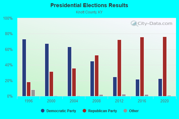
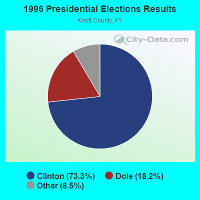
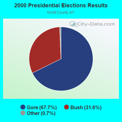
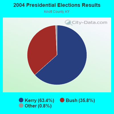
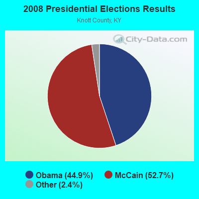
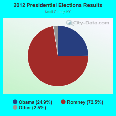
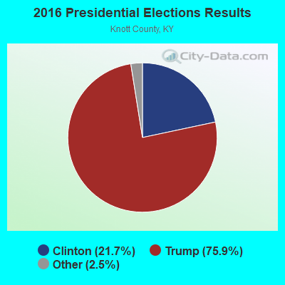
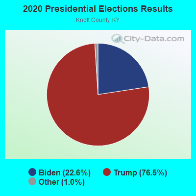
Graphs represent county-level data. Detailed 2008 Election Results
Religion statistics for Mousie, KY (based on Knott County data)
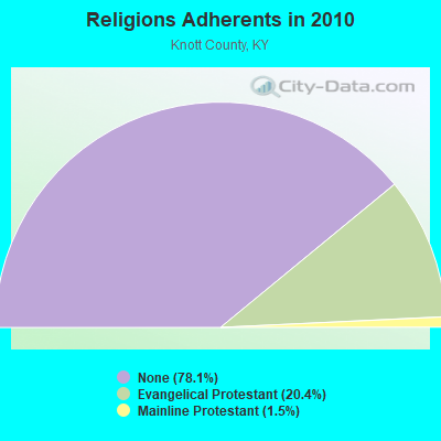
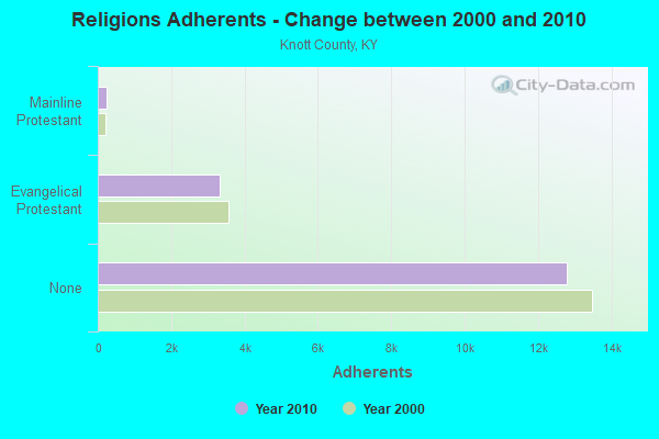
| Religion | Adherents | Congregations |
|---|---|---|
| Evangelical Protestant | 3,332 | 11 |
| Mainline Protestant | 243 | 1 |
| Other | 1 | 1 |
| None | 12,770 | - |
Food Environment Statistics:
| This county: | 3.48 / 10,000 pop. |
| Kentucky: | 2.19 / 10,000 pop. |
| Knott County: | 0.58 / 10,000 pop. |
| State: | 0.74 / 10,000 pop. |
| This county: | 3.48 / 10,000 pop. |
| State: | 4.36 / 10,000 pop. |
| Knott County: | 0.58 / 10,000 pop. |
| State: | 5.74 / 10,000 pop. |
| Here: | 13.0% |
| State: | 11.0% |
| This county: | 32.0% |
| Kentucky: | 30.0% |
| Knott County: | 22.6% |
| Kentucky: | 15.9% |
Strongest AM radio stations in Mousie:
- WPRT (960 AM; 5 kW; PRESTONSBURG, KY; Owner: EAST KENTUCKY RADIO NETWORK, INC.)
- WLSI (900 AM; 5 kW; PIKEVILLE, KY; Owner: EAST KENTUCKY BROADCASTING CORPORATION)
- WKYH (600 AM; 5 kW; PAINTSVILLE, KY; Owner: HIGHLANDS BROADCASTING CORPORATION)
- WDOC (1310 AM; 5 kW; PRESTONSBURG, KY)
- WTCW (920 AM; 4 kW; WHITESBURG, KY; Owner: T.C.W. BROADCASTING , INC.)
- WKCB (1340 AM; 1 kW; HINDMAN, KY; Owner: HINDMAN BROADCASTING CORPORATION)
- WEZC (1480 AM; daytime; 5 kW; NEON, KY; Owner: JESUS COMMUNICATION ILNC.)
- WKIC (1390 AM; 5 kW; HAZARD, KY)
- WEKG (810 AM; daytime; 5 kW; JACKSON, KY; Owner: INTERMOUNTAIN B/CING CO., INC.)
- WMTC (730 AM; 5 kW; VANCLEVE, KY; Owner: THE KENTUCKY MOUNTAIN HOLINESS ASSN.)
- WKVL (850 AM; daytime; 50 kW; KNOXVILLE, TN; Owner: HORNE RADIO, LLC)
- WTVN (610 AM; 50 kW; COLUMBUS, OH; Owner: CITICASTERS LICENSES, L.P.)
- WBPA (1460 AM; 5 kW; ELKHORN CITY, KY; Owner: EAST KENTUCKY BROADCASTING CORP)
Strongest FM radio stations in Mousie:
- WKCB-FM (107.1 FM; HINDMAN, KY; Owner: HINDMAN BROADCASTING CORPORATION)
- WWJD (91.7 FM; PIPPA PASSES, KY; Owner: ALICE LLOYD COLLEGE)
- WSGS (101.1 FM; HAZARD, KY; Owner: MOUNTAIN BROADCASTING SERVICE, INC.)
- WZQQ (97.9 FM; HYDEN, KY; Owner: LESLIE COUNTY BROADCASTING, INC.)
- WIFX-FM (94.3 FM; JENKINS, KY; Owner: LETCHER COUNTY BROADCASTING, INC)
- WXKQ-FM (103.9 FM; WHITESBURG, KY; Owner: T.C.W. BROADCASTING , INC.)
- WJMD (104.7 FM; HAZARD, KY; Owner: HAZARD BROADCASTING SERVICES)
- WMMT (88.7 FM; WHITESBURG, KY; Owner: APPALSHOP, INCORPORATED)
- WQHY (95.5 FM; PRESTONSBURG, KY; Owner: WDOC, INC.)
- WSEH (102.7 FM; CUMBERLAND, KY; Owner: CUMBERLAND CITY BROADCASTING, INC.)
- WDXC (102.3 FM; POUND, VA; Owner: WDXC RADIO, INC.)
- WEKH (90.9 FM; HAZARD, KY; Owner: EASTERN KENTUCKY UNIVERSITY)
- WDHR (93.1 FM; PIKEVILLE, KY; Owner: EAST KENTUCKY BROADCASTING CORP.)
- WZLK (107.5 FM; VIRGIE, KY; Owner: EAST KENTUCKY BROADCASTING CORPORATION)
- WAXM (93.5 FM; BIG STONE GAP, VA; Owner: VALLEY BROADCASTING, INC.)
- WXLR (104.9 FM; HAROLD, KY; Owner: ADAM D GEARHEART)
- WMDJ-FM (100.1 FM; ALLEN, KY; Owner: FLOYD COUNTY BROADCASTING CO., INC.)
- WPKE-FM (103.1 FM; COAL RUN, KY; Owner: EAST KENTUCKY BROADCASTING CORP.)
- W223AA (92.5 FM; BIG STONE GAP, VA; Owner: VALLEY BROADCASTING, INC.)
- WJSN-FM (106.5 FM; JACKSON, KY; Owner: INTERMOUNTAIN BROADCASTING CO.)
TV broadcast stations around Mousie:
- W26BK (Channel 26; TALBERT, KY; Owner: MS COMMUNICATIONS, LLC)
- WYMT-TV (Channel 57; HAZARD, KY; Owner: WYMT LICENSEE CORP.)
- W24BT (Channel 24; TALBERT, KY; Owner: MS COMMUNICATIONS, LLC)
- W16BI (Channel 16; TALBERT, KY; Owner: MS COMMUNICATIONS, LLC)
- WKHA (Channel 35; HAZARD, KY; Owner: KENTUCKY AUTHORITY FOR EDUCATIONAL TV)
- W31BU (Channel 31; TALBERT, KY; Owner: MS COMMUNICATIONS, LLC)
- W53BQ (Channel 53; TALBERT, KY; Owner: MS COMMUNICATIONS, LLC)
- W69ED (Channel 69; TALBERT, KY; Owner: MS COMMUNICATIONS, LLC)
- WUPX-TV (Channel 67; MOREHEAD, KY; Owner: PAXSON LEXINGTON LICENSE, INC.)
- W64CM (Channel 64; TALBERT, KY; Owner: MS COMMUNICATIONS, LLC)
- W66DA (Channel 66; TALBERT, KY; Owner: MS COMMUNICATIONS, LLC)
- WLJC-TV (Channel 65; BEATTYVILLE, KY; Owner: HOUR OF HARVEST, INC.)

FCC Registered Cell Phone Towers:
1 (See the full list of FCC Registered Cell Phone Towers in Mousie)FCC Registered Antenna Towers:
10 (See the full list of FCC Registered Antenna Towers)FCC Registered Private Land Mobile Towers:
3- 1 Mi N Rt 550 (Lat: 37.432611 Lon: -82.877389), Type: Pole, Structure height: 5 m, Call Sign: WPEX547,
Assigned Frequencies: 903.000 MHz, 909.990 MHz, 910.000 MHz, 915.750 MHz, 918.000 MHz, 921.500 MHz, 911.989 MHz, 911.994 MHz, Grant Date: 03/26/2004, Expiration Date: 05/18/2014, Cancellation Date: 05/13/2014, Registrant: Keller And Heckman LLP, 1001 G Street, N.W. Suite 500 West, Washington, DC 20001, Phone: (202) 434-4130, Fax: (202) 434-4646, Email:
- 1 Mi N Rt 550 (Lat: 37.441500 Lon: -82.887389), Structure height: 5 m, Call Sign: WPEX548,
Assigned Frequencies: 911.989 MHz, 918.009 MHz, Grant Date: 03/26/2004, Expiration Date: 05/18/2014, Cancellation Date: 05/13/2014, Registrant: Keller And Heckman LLP, 1001 G Street, N.W. Suite 500 West, Washington, DC 20001, Phone: (202) 434-4130, Fax: (202) 434-4646, Email:
- Jones Fork Loadout Four Mile Branch Ky Rt 550 One Mile N (Lat: 37.432056 Lon: -82.878500), Type: Building, Structure height: 2 m, Overall height: 3 m, Call Sign: WPLZ333,
Assigned Frequencies: 913.000 MHz, 918.150 MHz, Grant Date: 03/24/2003, Expiration Date: 04/22/2013, Cancellation Date: 06/08/2013, Certifier: Don Shillingburg, Registrant: Keller And Heckman LLP, 1001 G Street, Nw Suite 500 West, Washington, DC 20001, Phone: (202) 434-4130, Fax: (202) 434-4646, Email:
FCC Registered Broadcast Land Mobile Towers:
2- SIGNAL KNOB, Signal Knob (Lat: 37.484722 Lon: -82.929444), Type: Gtower, Structure height: 83 m, Overall height: 89 m, Call Sign: WZN247,
Assigned Frequencies: 151.115 MHz, Grant Date: 02/26/2014, Expiration Date: 05/25/2024, Registrant: Communications Section, 1239 Wilkinson Blvd, Frankfort, KY 40622, Phone: (502) 782-8995, Fax: (502) 564-3198, Email:
- State Forestry Tower Ky 80 5.2 Mi Ne (Lat: 37.484833 Lon: -82.929333), Call Sign: KKL458,
Assigned Frequencies: 155.475 MHz, 453.300 MHz, 453.300 MHz, 453.450 MHz, 453.450 MHz, 453.550 MHz, 453.550 MHz, 453.900 MHz, 453.900 MHz, 453.950 MHz, 453.950 MHz, Grant Date: 09/02/2021, Expiration Date: 10/20/2031, Registrant: Kentucky State Police, 1301 Louisville Rd, Frankfort, KY 40601, Phone: (502) 782-2067, Fax: (502) 227-8788, Email:
FCC Registered Microwave Towers:
6- 12SIGNAL KNB, Signal Knob (Lat: 37.484722 Lon: -82.929722), Type: Tower, Structure height: 83 m, Overall height: 89 m, Call Sign: WQHB635,
Assigned Frequencies: 6541.25 MHz, 6625.62 MHz, 6197.24 MHz, 6226.89 MHz, 6345.49 MHz, 6595.00 MHz, Grant Date: 04/26/2017, Expiration Date: 06/20/2027, Certifier: William F Hays, Registrant: Kentucky Emergency Warning System, 100 Minuteman Parkway, Building# 101, Frankfort, KY 40601, Phone: (502) 564-5397, Fax: (502) 564-6726, Email:
- Rockfork, Rock Fork Cell, 2.8 Km North Of (Lat: 37.444389 Lon: -82.879444), Type: Ltower, Structure height: 91.4 m, Overall height: 97.5 m, Call Sign: WQUU542,
Assigned Frequencies: 6137.92 MHz, 6137.92 MHz, 6137.92 MHz, 6137.92 MHz, 6137.92 MHz, 6137.92 MHz, Grant Date: 10/16/2014, Expiration Date: 10/16/2024, Certifier: Stanton Neece, Registrant: East Kentucky Network, LLC D/B/A Appalachian Wireless, 101 Technology Trail, Ivel, KY 41642, Phone: (606) 339-1006, Fax: (606) 339-1363, Email:
- 12 Signal Knob, Signal Knob (Lat: 37.484722 Lon: -82.929444), Type: Ltower, Structure height: 83 m, Overall height: 89 m, Call Sign: WQYH878,
Assigned Frequencies: 7112.50 MHz, Grant Date: 10/04/2016, Expiration Date: 08/01/2029, Certifier: Shae Hopkins, Registrant: Kentucky Authority For Educational Tv, 600 Cooper Dr, Lexington, KY 40502, Phone: (859) 258-7000, Email:
- 12 SIGNAL KNOB, Signal Knob (Lat: 37.484722 Lon: -82.929444), Type: Ltower, Structure height: 83 m, Overall height: 89 m, Call Sign: WCT832,
Assigned Frequencies: 6975.00 MHz, Grant Date: 07/02/1979, Expiration Date: 08/01/2029, Registrant: Kentucky Authority For Educational Tv, 600 Cooper Dr, Lexington, KY 40502, Phone: (859) 258-7000, Email:
- 12 SIGNAL KNOB, Signal Knob (Lat: 37.484722 Lon: -82.929444), Type: Ltower, Structure height: 83 m, Overall height: 89 m, Call Sign: WCT833,
Assigned Frequencies: 7050.00 MHz, Grant Date: 07/02/1979, Expiration Date: 08/01/2029, Registrant: Kentucky Authority For Educational Television, 600 Cooper Drive, Lexington, KY 40502, Phone: (859) 258-7000, Email:
- STATION, Signal Knob Lookout Tower Site 5 1/2 Mi Nw Of Mousie (Lat: 37.484806 Lon: -82.929306), Overall height: 89.3 m, Call Sign: WEE226,
Assigned Frequencies: 2146.00 MHz, 2135.60 MHz, 2132.40 MHz, Grant Date: 04/21/2011, Expiration Date: 07/18/2021, Cancellation Date: 06/18/2012, Registrant: Kentucky Emergency Warning System, 85 State Police Road, London, KY 40741, Phone: (502) 564-5397, Fax: (502) 564-6726, Email:

- 45.4%Electricity
- 41.6%Utility gas
- 4.9%Bottled, tank, or LP gas
- 3.9%Coal or coke
- 3.5%Fuel oil, kerosene, etc.
- 0.7%Wood

- 62.8%Electricity
- 33.9%Utility gas
- 3.2%Coal or coke
Mousie compared to Kentucky state average:
- Median household income below state average.
- Median house value significantly below state average.
- Black race population percentage significantly below state average.
- Hispanic race population percentage significantly below state average.
- Foreign-born population percentage significantly below state average.
- Length of stay since moving in significantly above state average.
- Number of rooms per house significantly below state average.
- House age significantly below state average.
- Number of college students below state average.
- Percentage of population with a bachelor's degree or higher below state average.
Mousie on our top lists:
- #10 on the list of "Top 101 cities with the largest percentage of people in homes for the mentally ill (population 1,000+)"
- #41 on the list of "Top 101 counties with the smallest number of people without health insurance coverage in 2000"
- #53 on the list of "Top 101 counties with the smallest number of children under 18 without health insurance coverage in 2000"