Mill Springs, Kentucky
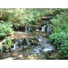
Mill Springs: waterfall at Mill Springs Park
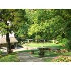
Mill Springs: from the top of the hill at Mill Springs Park
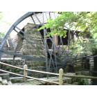
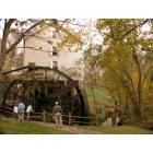
Mill Springs: the mill
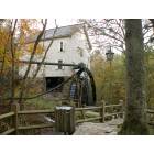
Mill Springs: Old Mill at Millsprings State Park near Mill Springs, KY
Mill Springs: Old Mill at Millsprings State Park near Mill Springs, KY
- add
your
Submit your own pictures of this place and show them to the world
- OSM Map
- General Map
- Google Map
- MSN Map

| Males: 2,109 | |
| Females: 2,086 |
| Median resident age: | 40.2 years |
| Kentucky median age: | 35.9 years |
Zip code: 42633
| Mill Springs: | $45,649 |
| KY: | $59,341 |
Estimated per capita income in 2022: $28,562 (it was $13,140 in 2000)
Mill Springs CCD income, earnings, and wages data
Estimated median house or condo value in 2022: $161,208 (it was $56,700 in 2000)
| Mill Springs: | $161,208 |
| KY: | $196,300 |
Mean prices in 2022: all housing units: $140,553; detached houses: $157,000; mobile homes: $73,995
Detailed information about poverty and poor residents in Mill Springs, KY


- 3,93996.7%White alone
- 912.2%Black alone
- 220.5%Two or more races
- 160.4%Hispanic
- 50.1%American Indian alone
- 10.02%Asian alone
- 10.02%Other race alone

Races in Mill Springs detailed stats: ancestries, foreign born residents, place of birth
 Recent articles from our blog. Our writers, many of them Ph.D. graduates or candidates, create easy-to-read articles on a wide variety of topics.
Current Local Time: EST time zone
Land area: 111.7 square miles.
Population density: 38 people per square mile (very low).

| Mill Springs CCD: | 0.6% ($360) |
| Kentucky: | 0.8% ($610) |
Nearest city with pop. 50,000+: Fayette, KY  (77.7 miles , pop. 260,512).
Nearest city with pop. 1,000,000+: Chicago, IL (371.6 miles , pop. 2,896,016).
Nearest cities:
), ), ), ), ), )Latitude: 36.94 N, Longitude: 84.83 W
Area code commonly used in this area: 606


| Here: | 5.0% |
| Kentucky: | 3.8% |

- Health care (9.8%)
- Educational services (9.5%)
- Agriculture, forestry, fishing & hunting (7.9%)
- Transportation equipment (6.8%)
- Accommodation & food services (6.4%)
- Construction (6.3%)
- Wood products (5.0%)

- Construction (11.6%)
- Transportation equipment (11.3%)
- Agriculture, forestry, fishing & hunting (11.1%)
- Wood products (8.5%)
- Metal & metal products (6.2%)
- Machinery (4.5%)
- Educational services (4.0%)

- Health care (19.5%)
- Educational services (16.1%)
- Accommodation & food services (9.8%)
- Finance & insurance (7.0%)
- Food & beverage stores (5.1%)
- Public administration (4.6%)
- Social assistance (4.6%)

- Other production occupations, including supervisors (8.0%)
- Metal workers and plastic workers (4.3%)
- Agricultural workers, including supervisors (3.9%)
- Retail sales workers, except cashiers (3.7%)
- Cashiers (3.6%)
- Laborers and material movers, hand (3.5%)
- Electrical equipment mechanics and other installation, maintenance, and repair workers, including supervisors (3.2%)

- Other production occupations, including supervisors (12.7%)
- Metal workers and plastic workers (7.9%)
- Electrical equipment mechanics and other installation, maintenance, and repair workers, including supervisors (5.9%)
- Farmers and farm managers (5.2%)
- Building and grounds cleaning and maintenance occupations (4.9%)
- Assemblers and fabricators (4.6%)
- Agricultural workers, including supervisors (4.4%)

- Cashiers (7.9%)
- Registered nurses (6.7%)
- Secretaries and administrative assistants (6.6%)
- Other office and administrative support workers, including supervisors (5.9%)
- Retail sales workers, except cashiers (5.5%)
- Child care workers (5.2%)
- Preschool, kindergarten, elementary, and middle school teachers (5.1%)
Average climate in Mill Springs, Kentucky
Based on data reported by over 4,000 weather stations


(lower is better)

Air Quality Index (AQI) level in 2022 was 62.9. This is about average.
| City: | 62.9 |
| U.S.: | 72.6 |

Ozone [ppb] level in 2022 was 28.6. This is about average. Closest monitor was 16.4 miles away from the city center.
| City: | 28.6 |
| U.S.: | 33.3 |

Particulate Matter (PM2.5) [µg/m3] level in 2022 was 7.87. This is about average. Closest monitor was 16.4 miles away from the city center.
| City: | 7.87 |
| U.S.: | 8.11 |
Tornado activity:
Mill Springs-area historical tornado activity is near Kentucky state average. It is 22% greater than the overall U.S. average.
On 4/3/1974, a category F4 (max. wind speeds 207-260 mph) tornado 3.4 miles away from the Mill Springs place center killed 10 people and injured 113 people and caused between $5000 and $50,000 in damages.
On 4/27/1971, a category F4 tornado 9.0 miles away from the place center killed 2 people and injured 72 people and caused between $500,000 and $5,000,000 in damages.
Earthquake activity:
Mill Springs-area historical earthquake activity is significantly above Kentucky state average. It is 102% greater than the overall U.S. average.On 7/27/1980 at 18:52:21, a magnitude 5.2 (5.1 MB, 4.7 MS, 5.0 UK, 5.2 UK, Class: Moderate, Intensity: VI - VII) earthquake occurred 100.2 miles away from Mill Springs center
On 4/18/2008 at 09:36:59, a magnitude 5.4 (5.1 MB, 4.8 MS, 5.4 MW, 5.2 MW) earthquake occurred 197.2 miles away from the city center
On 11/30/1973 at 07:48:41, a magnitude 4.7 (4.7 MB, 4.6 ML, Class: Light, Intensity: IV - V) earthquake occurred 92.5 miles away from the city center
On 4/18/2008 at 09:36:59, a magnitude 5.2 (5.2 MW, Depth: 8.9 mi) earthquake occurred 197.2 miles away from Mill Springs center
On 6/18/2002 at 17:37:15, a magnitude 5.0 (4.3 MB, 4.6 MW, 5.0 LG) earthquake occurred 177.4 miles away from Mill Springs center
On 9/7/1988 at 02:28:09, a magnitude 4.6 (4.5 MB, 4.6 LG) earthquake occurred 98.3 miles away from Mill Springs center
Magnitude types: regional Lg-wave magnitude (LG), body-wave magnitude (MB), local magnitude (ML), surface-wave magnitude (MS), moment magnitude (MW)
Natural disasters:
The number of natural disasters in Wayne County (15) is near the US average (15).Major Disasters (Presidential) Declared: 11
Emergencies Declared: 2
Causes of natural disasters: Floods: 8, Storms: 6, Mudslides: 3, Tornadoes: 3, Winter Storms: 3, Landslides: 2, Winds: 2, Blizzard: 1, Freeze: 1, Heavy Rain: 1, Hurricane: 1, Snow: 1, Snowfall: 1, Snowstorm: 1, Other: 1 (Note: some incidents may be assigned to more than one category).
Hospitals and medical centers near Mill Springs:
- WAYNE COUNTY HOSPITAL Critical Access Hospitals (about 9 miles away; MONTICELLO, KY)
- OAKWOOD COMMUNITY CENTER (Hospital, about 14 miles away; SOMERSET, KY)
- HOSPICE OF LAKE CUMBERLAND (Hospital, about 15 miles away; SOMERSET, KY)
- SOMERSET NURSING AND REHABILITATION FACILITY (Nursing Home, about 16 miles away; SOMERSET, KY)
Colleges/universities with over 2000 students nearest to Mill Springs:
- Somerset Community College (about 15 miles; Somerset, KY; Full-time enrollment: 4,698)
- Lindsey Wilson College (about 29 miles; Columbia, KY; FT enrollment: 2,552)
- University of the Cumberlands (about 40 miles; Williamsburg, KY; FT enrollment: 3,585)
- Campbellsville University (about 40 miles; Campbellsville, KY; FT enrollment: 2,948)
- Eastern Kentucky University (about 63 miles; Richmond, KY; FT enrollment: 13,525)
- Tennessee Technological University (about 65 miles; Cookeville, TN; FT enrollment: 9,761)
- Lincoln Memorial University (about 70 miles; Harrogate, TN; FT enrollment: 3,706)
Points of interest:
Notable locations in Mill Springs: Camp Earl Wallace (A), Beaver Lodge (B), Beaver Lodge Dock (C), Kelsay Mills (D), Shindig (E), The Pinnacle (F), Onion Point (G), Conley Bottom Dock (H). Display/hide their locations on the map
Churches in Mill Springs include: Fall Creek Church (A), Frazer Church (B), Little Sinking Church (C), Lockett Chapel (D), Meadow Creek Baptist Church (E), Morrow Chapel (F), Mount Hope Church (G), Mount Pleasant Church (H), New Bethel Church (I). Display/hide their locations on the map
Cemeteries: Bowling Cemetery (1), Coffey Cemetery (2), Cumberland Cemetery (3), Stringer Cemetery (4), Decker Cemetery (5), Wright Cemetery (6), Tabor-Russell Cemetery (7). Display/hide their locations on the map
Reservoir: Lake Cumberland (A). Display/hide its location on the map
Streams, rivers, and creeks: Dry Branch (A), Bee Lick Creek (B), Bell Branch (C), Difficulty Creek (D), Dean Branch (E), Cub Creek (F), Wolsey Branch (G), Cooper Branch (H), Thomas Branch (I). Display/hide their locations on the map
Parks in Mill Springs include: Mill Springs Battlefield (1), Mill Springs State Park (2), Cumberland Point Recreation Area (3), Fall Creek Recreation Area (4). Display/hide their locations on the map
Birthplace of: Malcolm Grear - Graphic designer.
| This place: | 2.4 people |
| Kentucky: | 2.5 people |
| This place: | 70.9% |
| Whole state: | 66.9% |
| This place: | 5.3% |
| Whole state: | 6.4% |
Likely homosexual households (counted as self-reported same-sex unmarried-partner households)
- Lesbian couples: 0.4% of all households
- Gay men: 0.4% of all households
| This place: | 24.0% |
| Whole state: | 15.8% |
| This place: | 7.3% |
| Whole state: | 6.6% |
For population 15 years and over in Mill Springs:

- Never married: 15.6%
- Now married: 69.3%
- Separated: 1.3%
- Widowed: 7.7%
- Divorced: 7.4%
For population 25 years and over in Mill Springs:
- High school or higher: 64.3%
- Bachelor's degree or higher: 8.9%
- Graduate or professional degree: 3.9%
- Unemployed: 9.1%
- Mean travel time to work (commute): 25.6 minutes


| Here: | 14.8 |
| Kentucky average: | 13.8 |
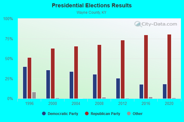
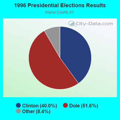
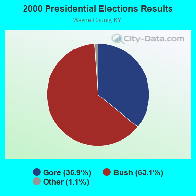
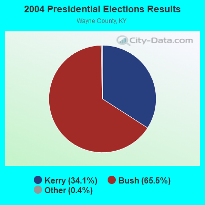
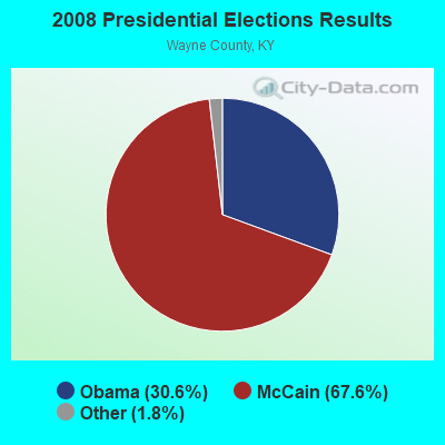
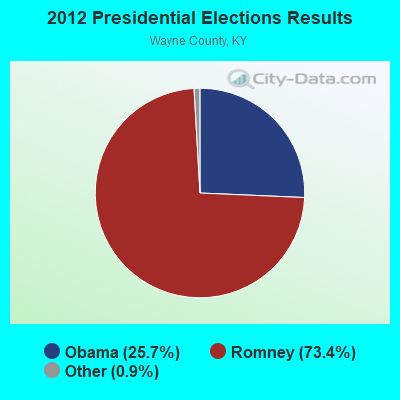
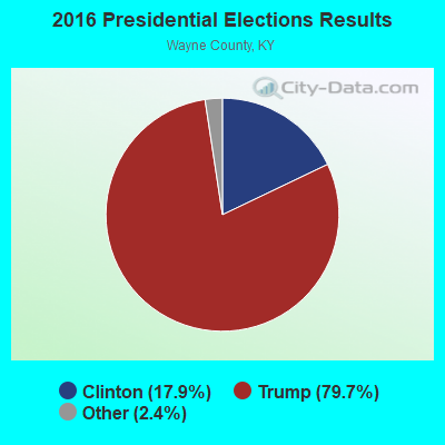
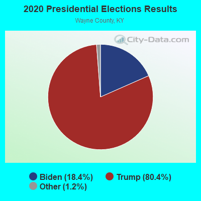
Graphs represent county-level data. Detailed 2008 Election Results
Religion statistics for Mill Springs, KY (based on Wayne County data)
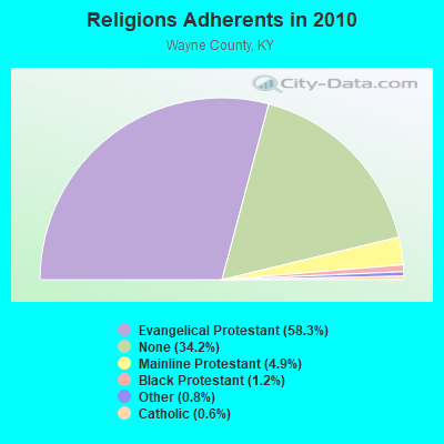
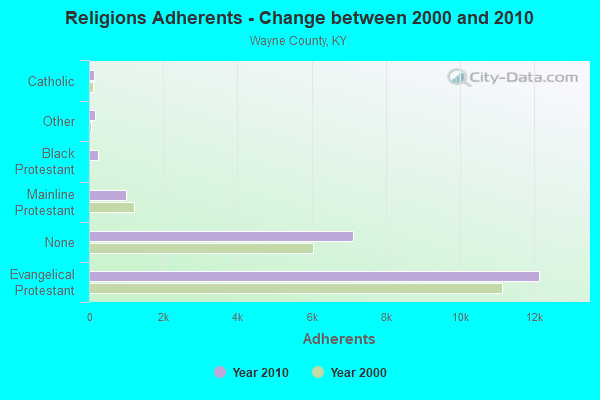
| Religion | Adherents | Congregations |
|---|---|---|
| Evangelical Protestant | 12,144 | 38 |
| Mainline Protestant | 1,010 | 8 |
| Black Protestant | 242 | 2 |
| Other | 158 | 2 |
| Catholic | 134 | 1 |
| None | 7,125 | - |
Food Environment Statistics:
| Wayne County: | 3.89 / 10,000 pop. |
| Kentucky: | 2.19 / 10,000 pop. |
| Wayne County: | 0.49 / 10,000 pop. |
| Kentucky: | 0.25 / 10,000 pop. |
| This county: | 0.49 / 10,000 pop. |
| State: | 0.74 / 10,000 pop. |
| Wayne County: | 3.40 / 10,000 pop. |
| Kentucky: | 4.36 / 10,000 pop. |
| This county: | 2.91 / 10,000 pop. |
| Kentucky: | 5.74 / 10,000 pop. |
| Here: | 10.9% |
| Kentucky: | 11.0% |
| Wayne County: | 31.1% |
| Kentucky: | 30.0% |
| This county: | 17.8% |
| State: | 15.9% |
Strongest AM radio stations in Mill Springs:
- WFLW (1360 AM; 1 kW; MONTICELLO, KY; Owner: STEPHEN W. STAPLES, JR.)
- WKVL (850 AM; daytime; 50 kW; KNOXVILLE, TN; Owner: HORNE RADIO, LLC)
- WHAS (840 AM; 50 kW; LOUISVILLE, KY; Owner: CLEAR CHANNEL BROADCASTING LICENSES, INC.)
- WSM (650 AM; 50 kW; NASHVILLE, TN; Owner: GAYLORD ENTERTAINMENT COMPANY)
- WJKY (1060 AM; daytime; 1 kW; JAMESTOWN, KY; Owner: LAKE CUMBERLAND BROADCASTERS)
- WEKC (710 AM; daytime; 4 kW; WILLIAMSBURG, KY; Owner: GERALD PARKS)
- WWAM (820 AM; daytime; 50 kW; JASPER, TN; Owner: SHELTON BROADCASTING SYSTEM)
- WTLO (1480 AM; 1 kW; SOMERSET, KY; Owner: CUMBERLAND COMMUNICATIONS, INC.)
- WAMB (1160 AM; 50 kW; DONELSON, TN; Owner: GREAT SOUTHERN BROADCASTING COMPANY, INC.)
- WKDA (1200 AM; 50 kW; NASHVILLE, TN; Owner: RADIO NASHVILLE, INC.)
- WIDS (570 AM; 0 kW; RUSSELL SPRINGS, KY; Owner: HAMMOND BROADCASTING, INC.)
- WFLI (1070 AM; 50 kW; LOOKOUT MOUNTAIN, TN; Owner: WFLI, INC.)
- WLAC (1510 AM; 50 kW; NASHVILLE, TN; Owner: CAPSTAR TX LIMITED PARTNERSHIP)
Strongest FM radio stations in Mill Springs:
- WMKZ (93.1 FM; MONTICELLO, KY; Owner: MONTICELLO-WAYNE COUNTY MEDIA, INC.)
- WKYM (101.7 FM; MONTICELLO, KY; Owner: STEPHEN W. STAPLES JR.)
- WSEK (97.1 FM; SOMERSET, KY; Owner: CAPSTAR TX LIMITED PARTNERSHIP)
- WKII-FM (102.3 FM; SOMERSET, KY; Owner: CAPSTAR TX LIMITED PARTNERSHIP)
- WTHL (90.5 FM; SOMERSET, KY; Owner: SOMERSET EDUCATIONAL BROADCASTING FOUNDATION)
- WJRS (104.9 FM; JAMESTOWN, KY; Owner: LAKE CUMBERLAND BROADCASTERS)
- WDCL-FM (89.7 FM; SOMERSET, KY; Owner: WESTERN KENTUCKY UNIVERSITY)
- WDVX (89.9 FM; CLINTON, TN; Owner: CUMBERLAND COMMUNITIES COMMUNI CORP.)
- WEKX (102.7 FM; JELLICO, TN; Owner: WHITLEY BROADCASTING CO., INC.)
- WHVE (92.7 FM; RUSSELL SPRINGS, KY; Owner: SHORELINE COMMUNICATIONS, INC)
- WLLK (93.9 FM; BURNSIDE, KY; Owner: CAPSTAR TX LIMITED PARTNERSHIP)
- W277AA (103.3 FM; SOMERSET, KY; Owner: WESTERN KENTUCKY UNIVERSITY)
- WHAY (105.9 FM; WHITLEY CITY, KY; Owner: TIM LAVENDER)
TV broadcast stations around Mill Springs:
- WKSO-TV (Channel 29; SOMERSET, KY; Owner: KENTUCKY AUTHORITY FOR EDUCATIONAL TV)
FCC Registered Broadcast Land Mobile Towers:
1- On Hwy 1275 1 Mi W Of Mill Springs State Park On Lake Cumberland (Lat: 36.935361 Lon: -84.788000), Structure height: 5 m, Call Sign: WPDU379,
Assigned Frequencies: 173.390 MHz, Grant Date: 12/18/2003, Expiration Date: 11/29/2013, Cancellation Date: 02/01/2014, Registrant: Monticello Utility Commission, 1100 North Main Street, Monticello, KY 42633, Phone: (606) 348-8473

- 57.2%Electricity
- 15.0%Wood
- 14.6%Bottled, tank, or LP gas
- 10.3%Fuel oil, kerosene, etc.
- 2.0%Coal or coke
- 0.5%Utility gas
- 0.5%Other fuel

- 46.0%Electricity
- 19.0%Bottled, tank, or LP gas
- 17.5%Fuel oil, kerosene, etc.
- 10.3%Wood
- 7.1%Coal or coke
Mill Springs compared to Kentucky state average:
- Black race population percentage significantly below state average.
- Hispanic race population percentage significantly below state average.
- Foreign-born population percentage significantly below state average.
- Renting percentage below state average.
- Length of stay since moving in significantly above state average.
- Number of rooms per house significantly below state average.
- House age significantly below state average.
- Percentage of population with a bachelor's degree or higher below state average.