Marshland, Oregon
Submit your own pictures of this place and show them to the world
- OSM Map
- General Map
- Google Map
- MSN Map

| Males: 248 | |
| Females: 214 |
| Median resident age: | 41.6 years |
| Oregon median age: | 36.3 years |
Zip code: 97016
| Marshland: | $122,889 |
| OR: | $75,657 |
Estimated per capita income in 2022: $49,773 (it was $25,894 in 2000)
Marshland CCD income, earnings, and wages data
Estimated median house or condo value in 2022: $393,606 (it was $140,600 in 2000)
| Marshland: | $393,606 |
| OR: | $475,600 |
Mean prices in 2022: all housing units: $468,897; detached houses: $502,753; townhouses or other attached units: $381,997; in 2-unit structures: $437,631; in 3-to-4-unit structures: $262,828; mobile homes: $316,065; occupied boats, rvs, vans, etc.: $92,803
Detailed information about poverty and poor residents in Marshland, OR


- 38893.9%White alone
- 112.7%Hispanic
- 71.7%Two or more races
- 61.5%American Indian alone
- 10.2%Black alone

Races in Marshland detailed stats: ancestries, foreign born residents, place of birth
 Recent articles from our blog. Our writers, many of them Ph.D. graduates or candidates, create easy-to-read articles on a wide variety of topics.

Current Local Time: PST time zone
Elevation: 53 feet
Land area: 22.4 square miles.
Population density: 21 people per square mile (very low).

| Marshland CCD: | 0.5% ($769) |
| Oregon: | 1.2% ($1,687) |
Nearest city with pop. 50,000+: Hillsboro, OR  (44.6 miles , pop. 70,186).
Nearest city with pop. 200,000+: Portland, OR (51.1 miles , pop. 529,121).
Nearest city with pop. 1,000,000+: Los Angeles, CA (871.7 miles , pop. 3,694,820).
Nearest cities:
), ), ), ), Latitude: 46.14 N, Longitude: 123.23 W


| Here: | 4.6% |
| Oregon: | 3.9% |

- Paper (18.9%)
- Agriculture, forestry, fishing & hunting (16.8%)
- Educational services (9.4%)
- Construction (8.6%)
- Utilities (7.8%)
- Food & beverage stores (6.6%)
- Transportation equipment (5.3%)

- Paper (25.2%)
- Agriculture, forestry, fishing & hunting (17.8%)
- Construction (15.6%)
- Utilities (14.1%)
- Transportation equipment (9.6%)
- Truck transportation (4.4%)
- Publishing, motion picture & sound recording industries (3.7%)

- Educational services (21.1%)
- Agriculture, forestry, fishing & hunting (15.6%)
- Food & beverage stores (14.7%)
- Paper (11.0%)
- Miscellaneous nondurable goods merchant wholesalers (8.3%)
- Public administration (7.3%)
- Publishing, motion picture & sound recording industries (4.6%)

- Engineers (11.1%)
- Other production occupations, including supervisors (10.7%)
- Farmers and farm managers (9.4%)
- Electrical equipment mechanics and other installation, maintenance, and repair workers, including supervisors (6.6%)
- Material recording, scheduling, dispatching, and distributing workers (5.3%)
- Preschool, kindergarten, elementary, and middle school teachers (4.9%)
- Information and record clerks, except customer service representatives (4.9%)

- Engineers (20.0%)
- Other production occupations, including supervisors (10.4%)
- Material recording, scheduling, dispatching, and distributing workers (9.6%)
- Electrical equipment mechanics and other installation, maintenance, and repair workers, including supervisors (8.1%)
- Farmers and farm managers (7.4%)
- Supervisors, construction and extraction workers (6.7%)
- Assemblers and fabricators (6.7%)

- Farmers and farm managers (11.9%)
- Preschool, kindergarten, elementary, and middle school teachers (11.0%)
- Information and record clerks, except customer service representatives (11.0%)
- Other production occupations, including supervisors (11.0%)
- Registered nurses (10.1%)
- Cashiers (8.3%)
- Agricultural workers, including supervisors (7.3%)
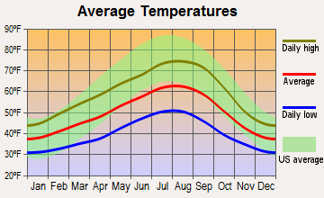
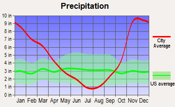
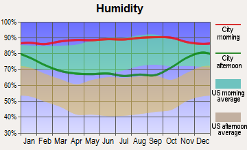
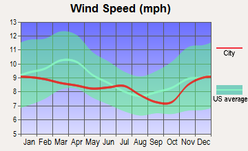
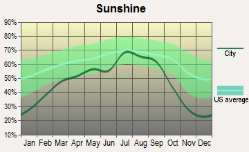
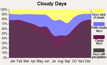
Average climate in Marshland, Oregon
Based on data reported by over 4,000 weather stations

(lower is better)

Air Quality Index (AQI) level in 2022 was 53.9. This is better than average.
| City: | 53.9 |
| U.S.: | 72.6 |

Particulate Matter (PM2.5) [µg/m3] level in 2022 was 5.45. This is significantly better than average. Closest monitor was 12.8 miles away from the city center.
| City: | 5.45 |
| U.S.: | 8.11 |
Earthquake activity:
Marshland-area historical earthquake activity is significantly above Oregon state average. It is 1417% greater than the overall U.S. average.On 4/13/1949 at 19:55:42, a magnitude 7.0 (7.0 UK, Class: Major, Intensity: VIII - XII) earthquake occurred 84.4 miles away from Marshland center, causing $80,000,000 total damage
On 2/28/2001 at 18:54:32, a magnitude 6.8 (6.5 MB, 6.6 MS, 6.8 MW, Class: Strong, Intensity: VII - IX) earthquake occurred 72.8 miles away from the city center, causing $2,000,000,000 total damage and $305,000,000 insured losses
On 2/28/2001 at 18:54:32, a magnitude 6.8 (6.8 MD, Depth: 32.2 mi) earthquake occurred 74.0 miles away from the city center
On 4/29/1965 at 15:28:43, a magnitude 6.6 (6.6 UK) earthquake occurred 92.0 miles away from Marshland center, causing $28,000,000 total damage
On 1/31/1922 at 13:17:28, a magnitude 7.6 (7.6 UK) earthquake occurred 393.7 miles away from the city center
On 8/17/1991 at 22:17:14, a magnitude 7.1 (6.2 MB, 7.1 MS, 7.1 MW, 6.8 ML, Depth: 8.4 mi) earthquake occurred 325.4 miles away from Marshland center
Magnitude types: body-wave magnitude (MB), duration magnitude (MD), local magnitude (ML), surface-wave magnitude (MS), moment magnitude (MW)
Natural disasters:
The number of natural disasters in Columbia County (15) is near the US average (15).Major Disasters (Presidential) Declared: 12
Emergencies Declared: 1
Causes of natural disasters: Floods: 9, Landslides: 6, Mudslides: 6, Winter Storms: 6, Storms: 5, Winds: 3, Snows: 2, Fire: 1, Heavy Rain: 1, Hurricane: 1, Other: 1 (Note: some incidents may be assigned to more than one category).
Hospitals and medical centers near Marshland:
- COLUMBIA VIEW CARE CENTER (Nursing Home, about 9 miles away; CATHLAMET, WA)
- COLUMBIA VIEW NURSING HOME (Nursing Home, about 9 miles away; CATHLAMET, WA)
- FMC LONGVIEW (Dialysis Facility, about 11 miles away; LONGVIEW, WA)
- PSA HEALTHCARE CERTIFIED (Home Health Center, about 13 miles away; LONGVIEW, WA)
- PEACHEALTH ST JOHN MEDICAL CENTER Acute Care Hospitals (about 14 miles away; LONGVIEW, WA)
- PARK ROYAL HEALTH AND REHAB CENTER (Nursing Home, about 14 miles away; LONGVIEW, WA)
- KINDRED TRANSITIONAL CARE AND REHAB CTR - BEACON HI (Nursing Home, about 14 miles away; LONGVIEW, WA)
Amtrak station near Marshland:
Colleges/universities with over 2000 students nearest to Marshland:
- Lower Columbia College (about 15 miles; Longview, WA; Full-time enrollment: 2,595)
- Centralia College (about 43 miles; Centralia, WA; FT enrollment: 2,354)
- Pacific University (about 43 miles; Forest Grove, OR; FT enrollment: 2,967)
- Clark College (about 45 miles; Vancouver, WA; FT enrollment: 9,330)
- University of Portland (about 46 miles; Portland, OR; FT enrollment: 4,030)
- Concordia University-Portland (about 49 miles; Portland, OR; FT enrollment: 3,996)
- Portland State University (about 51 miles; Portland, OR; FT enrollment: 21,450)
Points of interest:
Notable locations in Marshland: Port Westward Generating Project (A), Cascade Grain Products Ethanol Production Facility (B), Beaver Power Plant (C), Port Westward (D), Beaver Generating Plant (E). Display/hide their locations on the map
Lakes: Kerry Slough (A), Swampy Lake (B). Display/hide their locations on the map
Streams, rivers, and creeks: Tandy Creek (A), Beaver Creek (B), Beaver Slough (C), Clatskanie River (D), Eilertsen Creek (E), Graham Creek (F), McLean Slough (G), OK Creek (H), Olsen Creek (I). Display/hide their locations on the map
Beach: Jones Beach (A). Display/hide its location on the map
| This place: | 2.5 people |
| Oregon: | 2.5 people |
| This place: | 67.7% |
| Whole state: | 66.3% |
| This place: | 6.0% |
| Whole state: | 6.3% |
No gay or lesbian households reported
| This place: | 3.8% |
| Whole state: | 11.6% |
| This place: | 1.1% |
| Whole state: | 5.0% |
For population 15 years and over in Marshland:

- Never married: 7.4%
- Now married: 71.7%
- Separated: 1.4%
- Widowed: 0.0%
- Divorced: 21.0%
For population 25 years and over in Marshland:
- High school or higher: 85.5%
- Bachelor's degree or higher: 10.8%
- Graduate or professional degree: 1.2%
- Unemployed: 5.1%
- Mean travel time to work (commute): 23.2 minutes


| Here: | 8.2 |
| Oregon average: | 11.5 |
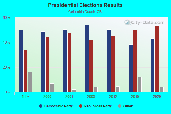
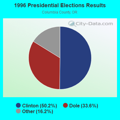
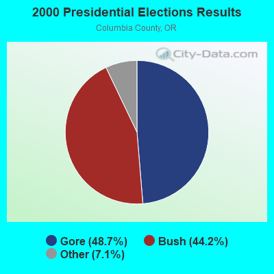
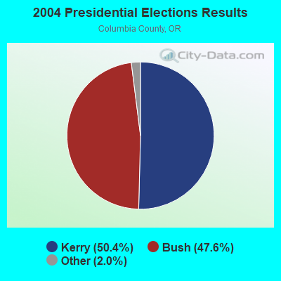
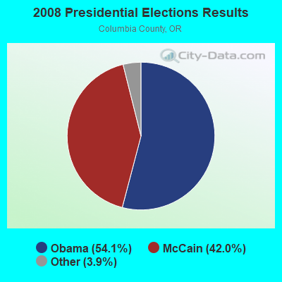
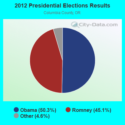
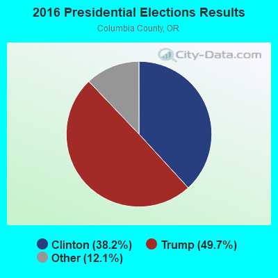
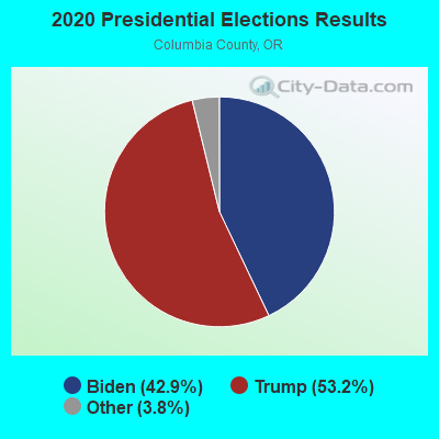
Graphs represent county-level data. Detailed 2008 Election Results
Religion statistics for Marshland, OR (based on Columbia County data)
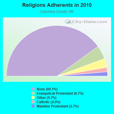
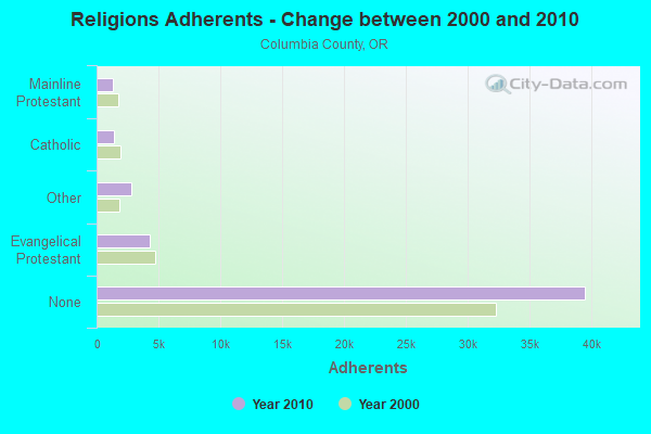
| Religion | Adherents | Congregations |
|---|---|---|
| Evangelical Protestant | 4,269 | 47 |
| Other | 2,835 | 11 |
| Catholic | 1,377 | 4 |
| Mainline Protestant | 1,342 | 9 |
| None | 39,528 | - |
Food Environment Statistics:
| Columbia County: | 1.84 / 10,000 pop. |
| Oregon: | 2.03 / 10,000 pop. |
| This county: | 0.20 / 10,000 pop. |
| Oregon: | 0.33 / 10,000 pop. |
| This county: | 1.02 / 10,000 pop. |
| Oregon: | 2.01 / 10,000 pop. |
| Columbia County: | 3.07 / 10,000 pop. |
| State: | 1.69 / 10,000 pop. |
| Columbia County: | 6.54 / 10,000 pop. |
| Oregon: | 9.93 / 10,000 pop. |
| Columbia County: | 8.1% |
| Oregon: | 7.4% |
| Columbia County: | 30.4% |
| Oregon: | 25.6% |
| Columbia County: | 19.7% |
| Oregon: | 14.2% |
Strongest AM radio stations in Marshland:
- KPAM (860 AM; 50 kW; TROUTDALE, OR; Owner: PAMPLIN BROADCASTING-OREGON, INC.)
- KBAM (1270 AM; 5 kW; LONGVIEW, WA; Owner: ENTERCOM LONGVIEW LICENSE, LLC)
- KPOJ (620 AM; 50 kW; PORTLAND, OR; Owner: CITICASTERS LICENSES, L.P.)
- KOTK (1080 AM; 50 kW; PORTLAND, OR; Owner: FISHER BROADCASTING - PORTLAND RADIO, L.L.C.)
- KXL (750 AM; 50 kW; PORTLAND, OR; Owner: ROSE CITY RADIO CORPORATION)
- KKAD (1550 AM; 50 kW; VANCOUVER, WA; Owner: PAMPLIN BROADCASTING-WASHINGTON, INC)
- KEX (1190 AM; 50 kW; PORTLAND, OR; Owner: CITICASTERS LICENSES, L.P.)
- KKSN (1520 AM; 50 kW; OREGON CITY, OR; Owner: ENTERCOM PORTLAND LICENSE, LLC)
- KAST (1370 AM; 10 kW; ASTORIA, OR; Owner: NEW NORTHWEST BROADCASTERS, LLC)
- KIRO (710 AM; 50 kW; SEATTLE, WA; Owner: ENTERCOM SEATTLE LICENSE, LLC)
- KJR (950 AM; 50 kW; SEATTLE, WA)
- KTTH (770 AM; 50 kW; SEATTLE, WA; Owner: ENTERCOM SEATTLE LICENSE, LLC)
- KGNW (820 AM; 50 kW; BURIEN-SEATTLE, WA; Owner: INSPIRATION MEDIA, INC.)
Strongest FM radio stations in Marshland:
- K216DH (91.1 FM; CATHLAMET, WA; Owner: TILLICUM FOUNDATION)
- K273AI (102.5 FM; ARIEL, WA; Owner: CALVARY CHAPEL OF TWIN FALLS, INC.)
- KRQT (107.1 FM; CASTLE ROCK, WA; Owner: ENTERCOM LONGVIEW LICENSE, LLC)
- KMNT (102.9 FM; CENTRALIA, WA; Owner: CITICASTERS LICENSES, L.P.)
- KLYK (94.5 FM; KELSO, WA; Owner: ENTERCOM LONGVIEW LICENSE, LLC)
- KJVH (89.5 FM; LONGVIEW, WA; Owner: FAMILY STATIONS, INC.)
- KUKN (105.5 FM; LONGVIEW, WA; Owner: WASHINGTON INTERSTATE BROADCASTING, INC.)
- KWYQ (90.3 FM; LONGVIEW, WA; Owner: WAY-FM MEDIA GROUP, INC.)
- KCBZ (94.9 FM; CANNON BEACH, OR; Owner: ENTERCOM PORTLAND LICENSE, LLC)
- KXXO (96.1 FM; OLYMPIA, WA; Owner: 3 CITIES, INC.)
- KFMY (97.7 FM; RAYMOND, WA; Owner: SOUTH SOUND BROADCASTING, LLC)
- K220HE (91.9 FM; CHEHALIS, WA; Owner: CALVARY CHAPEL OF TWIN FALLS, INC.)
- KMUN (91.9 FM; ASTORIA, OR; Owner: TILLICUM FOUNDATION)
- KWYA (89.7 FM; ASTORIA, OR; Owner: WAY-FM MEDIA GROUP, INC.)
- KITI-FM (95.1 FM; WINLOCK, WA; Owner: PREMIER BROADCASTERS, INC.)
- KRVO (105.9 FM; VANCOUVER, WA; Owner: CITICASTERS LICENSES, L.P.)
- KINK (101.9 FM; PORTLAND, OR; Owner: INFINITY RADIO OPERATIONS INC.)
- KKCW (103.3 FM; BEAVERTON, OR; Owner: CITICASTERS LICENSES, L.P.)
- KPDQ-FM (93.7 FM; PORTLAND, OR; Owner: SALEM MEDIA OF OREGON, INC.)
- KOPB-FM (91.5 FM; PORTLAND, OR; Owner: OREGON PUBLIC BROADCASTING)
TV broadcast stations around Marshland:
- K68DZ (Channel 68; LONGVIEW, WA; Owner: MEREDITH CORPORATION)

- 78.9%Electricity
- 21.1%Wood

- 51.4%Fuel oil, kerosene, etc.
- 48.6%Electricity
Marshland compared to Oregon state average:
- Median household income above state average.
- Unemployed percentage significantly below state average.
- Black race population percentage significantly below state average.
- Hispanic race population percentage significantly below state average.
- Median age above state average.
- Foreign-born population percentage significantly below state average.
- Renting percentage significantly below state average.
- Length of stay since moving in significantly above state average.
- Number of rooms per house significantly below state average.
- House age significantly below state average.
- Number of college students below state average.
- Percentage of population with a bachelor's degree or higher significantly below state average.
Marshland on our top lists:
- #64 on the list of "Top 100 low-educated but high-earning cities"
- #63 on the list of "Top 101 counties with the lowest Ozone (1-hour) air pollution readings in 2012 (ppm)"
- #88 on the list of "Top 101 counties with highest percentage of residents voting for 3rd party candidates in the 2012 Presidential Election"