Mantachie, Mississippi
Submit your own pictures of this town and show them to the world
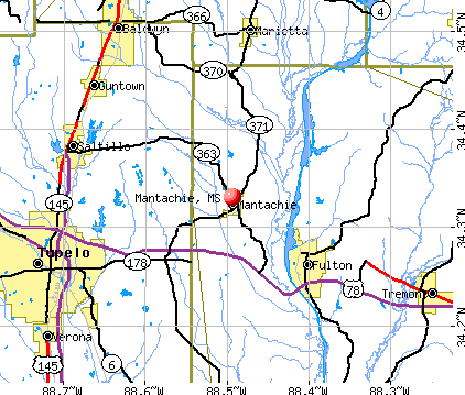
- OSM Map
- General Map
- Google Map
- MSN Map
Population change since 2000: +2.4%
 |
| Males: 547 | |
| Females: 587 |
| Median resident age: | 38.1 years |
| Mississippi median age: | 38.9 years |
Zip codes: 38855.
| Mantachie: | $70,973 |
| MS: | $52,719 |
Estimated per capita income in 2022: $55,811 (it was $16,164 in 2000)
Mantachie town income, earnings, and wages data
Estimated median house or condo value in 2022: $136,242 (it was $66,900 in 2000)
| Mantachie: | $136,242 |
| MS: | $162,500 |
Mean prices in 2022: all housing units: $161,963; detached houses: $168,576; mobile homes: $90,156
Median gross rent in 2022: $856.
(9.9% for White Non-Hispanic residents, 15.8% for Black residents, 36.1% for other race residents, 8.4% for two or more races residents)
Detailed information about poverty and poor residents in Mantachie, MS
Compare current foreclosures in Mantachie, MS:
| Photo | Address | Area | Beds / Baths | Price | Details |
|---|---|---|---|---|---|

|
#1
Starling Rd
Mantachie, MS 38855
|
1,144 sq. feet
|
1 baths 3 beds |
show details | |

|
#2
Bankhead Rd SW
Mantachie, MS 38855
|
- sq. feet
|
- baths - beds |
show details | |

|
#3
Shiloh Rd
Mantachie, MS 38855
|
1,371 sq. feet
|
- baths - beds |
show details | |

|
#4
Witt Rd
Mantachie, MS 38855
|
- sq. feet
|
- baths - beds |
show details | |

|
#5
Murphy Rd
Mantachie, MS 38855
|
1,344 sq. feet
|
- baths - beds |
show details | |

|
#6
Murphy Rd
Mantachie, MS 38855
|
1,248 sq. feet
|
- baths - beds |
show details | |

|
#7
Highway 178
Mantachie, MS 38855
|
- sq. feet
|
- baths - beds |
show details | |

|
#8
Walton Cemetery Rd
Mantachie, MS 38855
|
1,154 sq. feet
|
- baths - beds |
show details | |

|
#9
Dill Rd
Mantachie, MS 38855
|
1,775 sq. feet
|
- baths - beds |
show details | |

|
#10
Museum Dr
Mantachie, MS 38855
|
- sq. feet
|
- baths - beds |
show details |
| Photo | Address | Area | Beds / Baths | Price | Details |
|---|---|---|---|---|---|

|
#11
River Rd
Mantachie, MS 38855
|
- sq. feet
|
- baths - beds |
show details | |

|
#12
River Rd
Mantachie, MS 38855
|
1,725 sq. feet
|
- baths - beds |
show details | |

|
#13
Highway 363
Mantachie, MS 38855
|
1,557 sq. feet
|
- baths - beds |
show details | |

|
#14
Watson Dr # 2
Mantachie, MS 38855
|
- sq. feet
|
- baths - beds |
show details | |

|
#15
Oak Hollow Rd
Mantachie, MS 38855
|
- sq. feet
|
- baths - beds |
show details | |

|
#16
Leathers Dr
Mantachie, MS 38855
|
- sq. feet
|
- baths - beds |
show details | |

|
#17
Museum Dr
Mantachie, MS 38855
|
1,595 sq. feet
|
- baths - beds |
show details | |

|
#18
Justin Rd
Mantachie, MS 38855
|
- sq. feet
|
- baths - beds |
show details | |

|
#19
Devaughn Rd Apt 19
Mantachie, MS 38855
|
- sq. feet
|
- baths - beds |
show details | |

|
#20
Highway 371 N
Mantachie, MS 38855
|
1,280 sq. feet
|
- baths - beds |
show details |
| Photo | Address | Area | Beds / Baths | Price | Details |
|---|---|---|---|---|---|

|
#21
Sunset Dr
Mantachie, MS 38855
|
- sq. feet
|
- baths - beds |
show details | |

|
#22
Bankhead Rd SW
Mantachie, MS 38855
|
- sq. feet
|
- baths - beds |
show details | |

|
#23
Shiloh Rd
Mantachie, MS 38855
|
- sq. feet
|
- baths - beds |
show details | |

|
#24
Ivie Ln
Mantachie, MS 38855
|
- sq. feet
|
- baths - beds |
show details | |

|
#25
Murphy Rd
Mantachie, MS 38855
|
- sq. feet
|
- baths - beds |
show details | |

|
#26
Highway 371 N
Mantachie, MS 38855
|
- sq. feet
|
- baths - beds |
show details | |

|
#27
Sonny Rd
Mantachie, MS 38855
|
1,595 sq. feet
|
- baths - beds |
show details | |

|
#28
Museum Dr # 19
Mantachie, MS 38855
|
- sq. feet
|
- baths - beds |
show details | |

|
#29
Peck Rd
Mantachie, MS 38855
|
2,234 sq. feet
|
- baths - beds |
show details | |

|
#30
Dill Rd
Mantachie, MS 38855
|
- sq. feet
|
- baths - beds |
show details |
| Photo | Address | Area | Beds / Baths | Price | Details |
|---|---|---|---|---|---|

|
#31
River Rd
Mantachie, MS 38855
|
- sq. feet
|
- baths - beds |
show details | |

|
#32
Mantachie Creek Rd
Mantachie, MS 38855
|
1,369 sq. feet
|
- baths - beds |
show details | |

|
#33
Highway 371 N
Mantachie, MS 38855
|
1,100 sq. feet
|
- baths - beds |
show details | |

|
#34
Wisteria Ln
Mantachie, MS 38855
|
720 sq. feet
|
- baths - beds |
show details | |

|
#35
Voy Rd
Mantachie, MS 38855
|
- sq. feet
|
- baths - beds |
show details | |

|
#36
Voy Rd
Mantachie, MS 38855
|
- sq. feet
|
- baths - beds |
show details | |

|
#37
Highway 363
Mantachie, MS 38855
|
- sq. feet
|
- baths - beds |
show details | |

|
Check over 1 million property listings on Foreclosure.com!
|
browse all offers | |||


- 1,47782.5%White alone
- 1417.9%Two or more races
- 1015.6%Hispanic
- 633.5%Other race alone
- 553.1%Black alone

Races in Mantachie detailed stats: ancestries, foreign born residents, place of birth
According to our research of Mississippi and other state lists, there were 13 registered sex offenders living in Mantachie, Mississippi as of May 22, 2024.
The ratio of all residents to sex offenders in Mantachie is 111 to 1.
 Recent articles from our blog. Our writers, many of them Ph.D. graduates or candidates, create easy-to-read articles on a wide variety of topics.

 | Saltillo, Fulton, Mantachie MS (4 replies) |
| What do you think of TUPELO, MS? (37 replies) |
| Relocating to Mississippi (48 replies) |
| Need info on moving to N. MS. (9 replies) |
| Moving to Tupleo, is it safe? (8 replies) |
Latest news from Mantachie, MS collected exclusively by city-data.com from local newspapers, TV, and radio stations
Ancestries: Irish (19.1%), American (19.0%), English (17.4%), German (2.5%), Scotch-Irish (2.1%), Scottish (1.5%).
Current Local Time: CST time zone
Elevation: 356 feet
Land area: 3.95 square miles.
Population density: 287 people per square mile (very low).
2 residents are foreign born
| This town: | 0.2% |
| Mississippi: | 1.4% |
| Mantachie town: | 0.4% ($246) |
| Mississippi: | 0.7% ($425) |
Nearest city with pop. 50,000+: Decatur, AL  (87.8 miles , pop. 53,929).
Nearest city with pop. 200,000+: Memphis, TN (100.1 miles , pop. 650,100).
Nearest city with pop. 1,000,000+: Dallas, TX (489.4 miles , pop. 1,188,580).
Nearest cities:
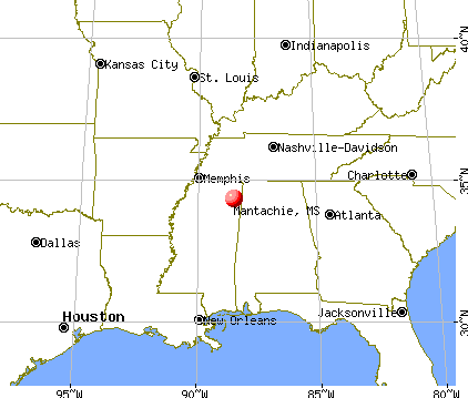
), ), ), Latitude: 34.33 N, Longitude: 88.49 W
Area code: 662


Single-family new house construction building permits:
- 2022: 1 building, cost: $115,000
- 2021: 4 buildings, average cost: $209,100
- 2020: 3 buildings, average cost: $209,100
- 2019: 3 buildings, average cost: $135,000
- 2011: 1 building, cost: $85,000
- 2008: 5 buildings, average cost: $96,000
- 2007: 2 buildings, average cost: $66,700
- 2006: 3 buildings, average cost: $66,700
- 2003: 5 buildings, average cost: $83,200
- 2002: 11 buildings, average cost: $80,500
- 2001: 2 buildings, average cost: $55,000
- 2000: 2 buildings, average cost: $55,000
- 1999: 6 buildings, average cost: $95,500
- 1998: 14 buildings, average cost: $16,800
- 1997: 15 buildings, average cost: $33,600


| Here: | 2.3% |
| Mississippi: | 2.6% |

- Furniture & related product manufacturing (16.7%)
- Health care (10.2%)
- Educational services (7.7%)
- Construction (6.3%)
- Public administration (4.7%)
- Paper (3.7%)
- Accommodation & food services (2.8%)

- Furniture & related product manufacturing (18.6%)
- Construction (11.5%)
- Paper (6.5%)
- Public administration (4.3%)
- Professional, scientific, technical services (3.6%)
- Machinery (3.2%)
- Metal & metal products (2.9%)

- Health care (19.2%)
- Furniture & related product manufacturing (14.4%)
- Educational services (13.5%)
- Public administration (5.2%)
- Finance & insurance (5.2%)
- Accommodation & food services (4.4%)
- Apparel (3.9%)

- Other production occupations, including supervisors (10.6%)
- Textile, apparel, and furnishings workers (6.7%)
- Electrical equipment mechanics and other installation, maintenance, and repair workers, including supervisors (5.7%)
- Assemblers and fabricators (5.3%)
- Driver/sales workers and truck drivers (4.3%)
- Secretaries and administrative assistants (4.1%)
- Other office and administrative support workers, including supervisors (3.9%)

- Other production occupations, including supervisors (11.5%)
- Electrical equipment mechanics and other installation, maintenance, and repair workers, including supervisors (10.4%)
- Driver/sales workers and truck drivers (7.9%)
- Assemblers and fabricators (7.9%)
- Textile, apparel, and furnishings workers (5.4%)
- Construction traders workers except carpenters, electricians, painters, plumbers, and construction laborers (4.3%)
- Material recording, scheduling, dispatching, and distributing workers (4.3%)

- Other production occupations, including supervisors (9.6%)
- Secretaries and administrative assistants (9.2%)
- Textile, apparel, and furnishings workers (8.3%)
- Other office and administrative support workers, including supervisors (7.9%)
- Preschool, kindergarten, elementary, and middle school teachers (4.4%)
- Bookkeeping, accounting, and auditing clerks (4.4%)
- Health technologists and technicians (3.1%)
Average climate in Mantachie, Mississippi
Based on data reported by over 4,000 weather stations


|
|


(lower is better)

Air Quality Index (AQI) level in 2022 was 57.9. This is better than average.
| City: | 57.9 |
| U.S.: | 72.6 |

Ozone [ppb] level in 2022 was 30.6. This is about average. Closest monitor was 15.6 miles away from the city center.
| City: | 30.6 |
| U.S.: | 33.3 |

Particulate Matter (PM2.5) [µg/m3] level in 2012 was 10.1. This is worse than average. Closest monitor was 16.2 miles away from the city center.
| City: | 10.1 |
| U.S.: | 8.1 |
Tornado activity:
Mantachie-area historical tornado activity is near Mississippi state average. It is 102% greater than the overall U.S. average.
On 4/29/1963, a category F4 (max. wind speeds 207-260 mph) tornado 15.4 miles away from the Mantachie town center killed 3 people and injured 20 people and caused between $50,000 and $500,000 in damages.
On 4/3/1974, a category F5 (max. wind speeds 261-318 mph) tornado 40.4 miles away from the town center killed 28 people and injured 272 people.
Earthquake activity:
Mantachie-area historical earthquake activity is significantly above Mississippi state average. It is 245% greater than the overall U.S. average.On 3/25/1976 at 00:41:20, a magnitude 5.0 (4.9 MB, 5.0 LG, Class: Moderate, Intensity: VI - VII) earthquake occurred 137.7 miles away from the city center
On 1/18/1999 at 07:00:53, a magnitude 4.8 (4.8 MB, 4.0 LG, Depth: 0.6 mi, Class: Light, Intensity: IV - V) earthquake occurred 95.7 miles away from Mantachie center
On 6/24/1975 at 11:11:36, a magnitude 4.5 (4.5 MB) earthquake occurred 56.5 miles away from Mantachie center
On 5/4/1991 at 01:18:54, a magnitude 5.0 (4.4 MB, 4.6 LG, 5.0 LG, Depth: 3.1 mi) earthquake occurred 171.7 miles away from the city center
On 4/29/2003 at 08:59:39, a magnitude 4.9 (4.4 MB, 4.6 MW, 4.9 LG) earthquake occurred 163.8 miles away from the city center
On 4/27/1989 at 16:47:49, a magnitude 4.7 (4.6 MB, 4.7 LG, 4.3 LG) earthquake occurred 136.4 miles away from the city center
Magnitude types: regional Lg-wave magnitude (LG), body-wave magnitude (MB), moment magnitude (MW)
Natural disasters:
The number of natural disasters in Itawamba County (18) is near the US average (15).Major Disasters (Presidential) Declared: 13
Emergencies Declared: 1
Causes of natural disasters: Storms: 12, Floods: 10, Tornadoes: 10, Winds: 6, Freezes: 3, Hurricanes: 2, Winter Storms: 2, Drought: 1, Heavy Rain: 1, Other: 1 (Note: some incidents may be assigned to more than one category).

Hospitals and medical centers near Mantachie:
- ITAWAMBA COUNTY HOSPITAL (Hospital, about 7 miles away; FULTON, MS)
- COURTYARDS COMM LIVING CENTER (Nursing Home, about 8 miles away; FULTON, MS)
- DANIEL HEALTH CARE, INC (Nursing Home, about 9 miles away; FULTON, MS)
- SOUTHERN CARE TUPELO (Hospital, about 12 miles away; TUPELO, MS)
- GOLDEN LIVINGCENTER - EASON BOULEVARD (Nursing Home, about 12 miles away; TUPELO, MS)
- TUPELO NURSING AND REHABILITATION CENTER (Nursing Home, about 13 miles away; TUPELO, MS)
- NORTH MISSISSIPPI STATE HOSPITAL (Hospital, about 13 miles away; TUPELO, MS)
Airports located in Mantachie:
- Lamb's Field Airport (MS68) (Runways: 1)
Colleges/universities with over 2000 students nearest to Mantachie:
- Itawamba Community College (about 6 miles; Fulton, MS; Full-time enrollment: 5,489)
- Northeast Mississippi Community College (about 24 miles; Booneville, MS; FT enrollment: 3,024)
- Northwest-Shoals Community College (about 55 miles; Muscle Shoals, AL; FT enrollment: 2,702)
- University of North Alabama (about 57 miles; Florence, AL; FT enrollment: 5,886)
- Mississippi University for Women (about 59 miles; Columbus, MS; FT enrollment: 2,565)
- University of Mississippi (about 60 miles; University, MS; FT enrollment: 17,642)
- Mississippi State University (about 63 miles; Mississippi State, MS; FT enrollment: 18,237)
Public high school in Mantachie:
- MANTACHIE ATTENDANCE CENTER (Location: MUSTANG DRIVE, Grades: KG-12)
Points of interest:
Notable locations in Mantachie: Greater Mantachie Fire and Rescue Substation (A), Greater Mantachie Fire and Rescue Station 200 (B). Display/hide their locations on the map
Church in Mantachie: Mantachie First Baptist Church (A). Display/hide its location on the map
Cemetery: Mantachie Cemetery (1). Display/hide its location on the map
Tourist attractions: Bonds House (Cultural Attractions- Events- & Facilities; 44 Museum Drive), Itawamba Historical Society (Historical Places & Services; 44 Museum Drive).
| This town: | 2.2 people |
| Mississippi: | 2.6 people |
| This town: | 62.8% |
| Whole state: | 69.0% |
| This town: | 2.5% |
| Whole state: | 5.7% |
Likely homosexual households (counted as self-reported same-sex unmarried-partner households)
- Lesbian couples: 0.2% of all households
- Gay men: 0.0% of all households
Banks with branches in Mantachie (2011 data):
- Farmers and Merchants Bank: Mantachie Branch at 5600 Highway 363, branch established on 2006/10/23. Info updated 2006/11/03: Bank assets: $205.1 mil, Deposits: $168.6 mil, headquarters in Baldwyn, MS, positive income, Commercial Lending Specialization, 7 total offices
- BancorpSouth Bank: Mantachie Branch at 3230 Highway 371, branch established on 1962/03/24. Info updated 2007/07/18: Bank assets: $12,990.3 mil, Deposits: $10,863.8 mil, headquarters in Tupelo, MS, positive income, Commercial Lending Specialization, 271 total offices, Holding Company: Bancorpsouth, Inc.
For population 15 years and over in Mantachie:

- Never married: 23.2%
- Now married: 52.1%
- Separated: 1.1%
- Widowed: 10.0%
- Divorced: 13.7%
For population 25 years and over in Mantachie:
- High school or higher: 81.6%
- Bachelor's degree or higher: 17.0%
- Graduate or professional degree: 3.2%
- Unemployed: 3.4%
- Mean travel time to work (commute): 25.1 minutes


| Here: | 14.6 |
| Mississippi average: | 11.8 |


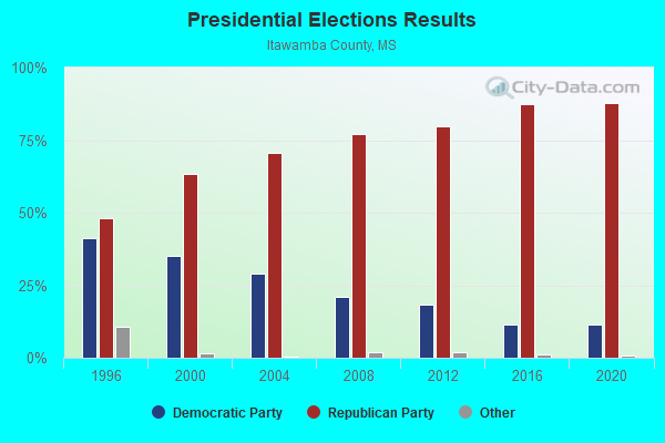
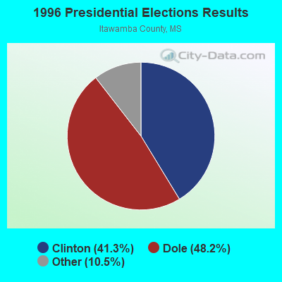
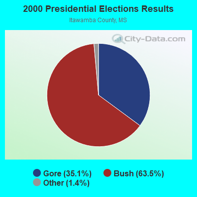
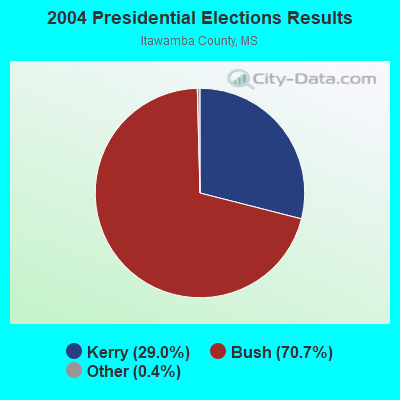
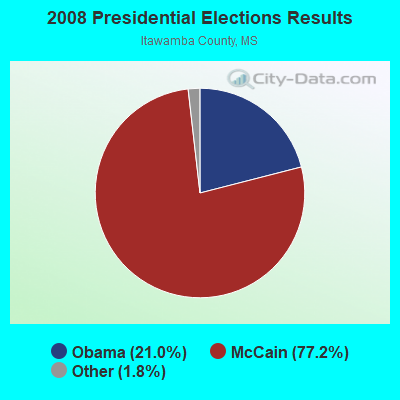
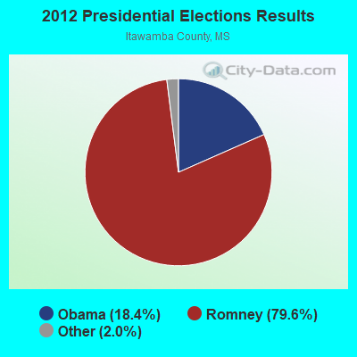
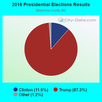
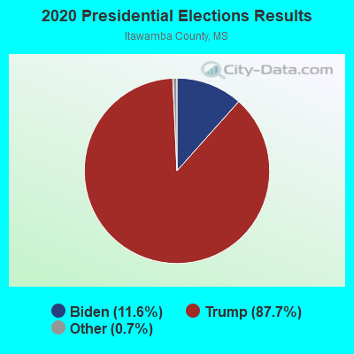
Graphs represent county-level data. Detailed 2008 Election Results
Religion statistics for Mantachie, MS (based on Itawamba County data)
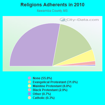
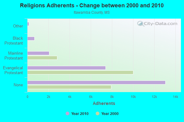
| Religion | Adherents | Congregations |
|---|---|---|
| Evangelical Protestant | 7,398 | 49 |
| Mainline Protestant | 2,053 | 15 |
| Black Protestant | 667 | 4 |
| Other | 157 | 1 |
| Catholic | 67 | 1 |
| None | 13,059 | - |
Food Environment Statistics:
| Here: | 2.17 / 10,000 pop. |
| Mississippi: | 2.08 / 10,000 pop. |
| Itawamba County: | 0.43 / 10,000 pop. |
| Mississippi: | 0.24 / 10,000 pop. |
| Itawamba County: | 0.43 / 10,000 pop. |
| State: | 0.80 / 10,000 pop. |
| Itawamba County: | 5.21 / 10,000 pop. |
| State: | 6.36 / 10,000 pop. |
| This county: | 5.21 / 10,000 pop. |
| Mississippi: | 5.03 / 10,000 pop. |
| This county: | 11.7% |
| State: | 12.3% |
| This county: | 28.8% |
| State: | 33.1% |
| Itawamba County: | 17.8% |
| State: | 14.4% |
Health and Nutrition:
| This city: | 49.0% |
| Mississippi: | 48.6% |
| Mantachie: | 42.9% |
| State: | 45.3% |
| Mantachie: | 29.0 |
| Mississippi: | 29.2 |
| Here: | 18.7% |
| Mississippi: | 20.5% |
| Mantachie: | 7.7% |
| Mississippi: | 11.6% |
| This city: | 6.8 |
| Mississippi: | 6.7 |
| Mantachie: | 27.6% |
| Mississippi: | 34.8% |
| Mantachie: | 58.1% |
| Mississippi: | 54.9% |
| Here: | 75.2% |
| Mississippi: | 79.9% |
More about Health and Nutrition of Mantachie, MS Residents
| Local government employment and payroll (March 2022) | |||||
| Function | Full-time employees | Monthly full-time payroll | Average yearly full-time wage | Part-time employees | Monthly part-time payroll |
|---|---|---|---|---|---|
| Other Government Administration | 7 | $4,472 | $7,666 | 1 | $180 |
| Police Protection - Officers | 2 | $5,760 | $34,560 | 9 | $1,683 |
| Water Supply | 2 | $6,560 | $39,360 | 0 | $0 |
| Parks and Recreation | 0 | $0 | 1 | $700 | |
| Judicial and Legal | 0 | $0 | 1 | $1,515 | |
| Totals for Government | 11 | $16,792 | $18,319 | 12 | $4,078 |
Mantachie government finances - Expenditure in 2017 (per resident):
- Construction - Water Utilities: $214,000 ($188.71)
- Current Operations - Electric Utilities: $2,083,000 ($1836.86)
Police Protection: $294,000 ($259.26)
Local Fire Protection: $140,000 ($123.46)
Water Utilities: $137,000 ($120.81)
Solid Waste Management: $133,000 ($117.28)
Regular Highways: $129,000 ($113.76)
Sewerage: $107,000 ($94.36)
Central Staff Services: $94,000 ($82.89)
Parks and Recreation: $86,000 ($75.84)
Financial Administration: $50,000 ($44.09)
Libraries: $38,000 ($33.51)
General Public Buildings: $27,000 ($23.81)
Judicial and Legal Services: $13,000 ($11.46)
General - Other: $12,000 ($10.58)
- Electric Utilities - Interest on Debt: $8,000 ($7.05)
- General - Interest on Debt: $7,000 ($6.17)
- Other Capital Outlay - Electric Utilities: $86,000 ($75.84)
General Public Building: $52,000 ($45.86)
Parks and Recreation: $36,000 ($31.75)
General - Other: $36,000 ($31.75)
Police Protection: $27,000 ($23.81)
Regular Highways: $17,000 ($14.99)
Local Fire Protection: $10,000 ($8.82)
Solid Waste Management: $8,000 ($7.05)
Sewerage: $5,000 ($4.41)
Libraries: $1,000 ($0.88)
- Total Salaries and Wages: $522,000 ($460.32)
Mantachie government finances - Revenue in 2017 (per resident):
- Charges - Solid Waste Management: $121,000 ($106.70)
Sewerage: $110,000 ($97.00)
Other: $12,000 ($10.58)
Parks and Recreation: $2,000 ($1.76)
- Local Intergovernmental - General Local Government Support: $63,000 ($55.56)
Other: $6,000 ($5.29)
- Miscellaneous - Fines and Forfeits: $33,000 ($29.10)
Rents: $18,000 ($15.87)
Sale of Property: $14,000 ($12.35)
General Revenue - Other: $9,000 ($7.94)
Interest Earnings: $6,000 ($5.29)
- Revenue - Electric Utilities: $2,321,000 ($2046.74)
Water Utilities: $157,000 ($138.45)
- State Intergovernmental - General Local Government Support: $282,000 ($248.68)
Water Utilities: $132,000 ($116.40)
Other: $118,000 ($104.06)
Highways: $2,000 ($1.76)
- Tax - Property: $287,000 ($253.09)
Public Utilities Sales: $12,000 ($10.58)
Other License: $8,000 ($7.05)
Mantachie government finances - Debt in 2017 (per resident):
- Long Term Debt - Beginning Outstanding - Unspecified Public Purpose: $347,000 ($306.00)
Outstanding Unspecified Public Purpose: $303,000 ($267.20)
Retired Unspecified Public Purpose: $44,000 ($38.80)
Mantachie government finances - Cash and Securities in 2017 (per resident):
- Other Funds - Cash and Securities: $848,000 ($747.80)
- Sinking Funds - Cash and Securities: $24,000 ($21.16)
Strongest AM radio stations in Mantachie:
- WFTO (1330 AM; 5 kW; FULTON, MS; Owner: AIR SOUTH RADIO, INC.)
- WCPC (940 AM; 50 kW; HOUSTON, MS; Owner: WCPC BROADCASTING CO., INC.)
- WELO (580 AM; 1 kW; TUPELO, MS; Owner: SAN DOW BROADCASTING, INC.)
- WCRV (640 AM; 50 kW; COLLIERVILLE, TN; Owner: BOTT BROADCASTING COMPANY/TENNESSEE)
- WJOX (690 AM; 50 kW; BIRMINGHAM, AL; Owner: CITADEL BROADCASTING COMPANY)
- WKMQ (1060 AM; daytime; 1 kW; TUPELO, MS; Owner: CAPSTAR TX LIMITED PARTNERSHIP)
- WERH (970 AM; 5 kW; HAMILTON, AL; Owner: KATE F. FITE)
- WGSF (1030 AM; 50 kW; MEMPHIS, TN; Owner: FLINN BROADCASTING CORPORATION)
- WDJC (850 AM; 50 kW; BIRMINGHAM, AL; Owner: KIMTRON, INC.)
- WTUP (1490 AM; 1 kW; TUPELO, MS; Owner: CAPSTAR TX LIMITED PARTNERSHIP)
- WAPI (1070 AM; 50 kW; BIRMINGHAM, AL; Owner: CITADEL BROADCASTING COMPANY)
- WDIA (1070 AM; 50 kW; MEMPHIS, TN; Owner: CLEAR CHANNEL BROADCASTING LICENSES, INC.)
- WMQM (1600 AM; 50 kW; LAKELAND, TN; Owner: WMQM, INC.)
Strongest FM radio stations in Mantachie:
- WFTA (101.9 FM; FULTON, MS; Owner: AIR SOUTH RADIO, INC.)
- WZLQ (98.5 FM; TUPELO, MS; Owner: SAN DOW BROADCASTING)
- WESE (92.5 FM; BALDWYN, MS; Owner: CAPSTAR TX LIMITED PARTNERSHIP)
- WAFR (88.3 FM; TUPELO, MS; Owner: AMERICAN FAMILY ASSOCIATION)
- WSYE (93.3 FM; HOUSTON, MS; Owner: JMD, INC.)
- WAQB (90.9 FM; TUPELO, MS; Owner: AMERICAN FAMILY ASSOCIATION)
- WWZD-FM (106.7 FM; NEW ALBANY, MS; Owner: CAPSTAR TX LIMITED PARTNERSHIP)
- WMAE-FM (89.5 FM; BOONEVILLE, MS; Owner: MISSISSIPPI AUTHORITY FOR EDUCATIONAL TV)
- WWMS (97.5 FM; OXFORD, MS; Owner: SAN-DOW BROADCASTING, INC.)
- WSEL-FM (96.7 FM; PONTOTOC, MS; Owner: OLLIE COLLINS, JR.)
- WWKZ (105.3 FM; ABERDEEN, MS; Owner: CAPSTAR TX LIMITED PARTNERSHIP)
- WAJS (91.7 FM; TUPELO, MS; Owner: AMERICAN FAMILY ASSOCIATION)
- WBIP-FM (99.3 FM; BOONEVILLE, MS; Owner: CLEAR CHANNEL BROADCASTING LICENSES, INC.)
TV broadcast stations around Mantachie:
- W45BD (Channel 45; TUPELO, MS; Owner: WTVA, INC.)
- W22BS (Channel 22; TUPELO, MS; Owner: WTVA, INC.)
- W49BK (Channel 49; ACTON, TN; Owner: MS COMMUNICATIONS, LLC)
- W14BW (Channel 14; ACTON, TN; Owner: MS COMMUNICATIONS, LLC)
- W32BH (Channel 32; TUPELO, MS; Owner: WTVA, INC.)
- WTVA (Channel 9; TUPELO, MS; Owner: WTVA, INC.)
- WCBI-TV (Channel 4; COLUMBUS, MS; Owner: COLUMBUS TELEVISION, INC.)
- WHDF (Channel 15; FLORENCE, AL; Owner: VALLEY TELEVISION, LLC)
- WKDH (Channel 45; HOUSTON, MS; Owner: SOUTHERN BROADCASTING, INC.)
- WLOV-TV (Channel 27; WEST POINT, MS; Owner: LINGARD BROADCASTING CORPORATION)
- W39CD (Channel 38; FULTON, MS; Owner: UNITY BROADCASTING, INC.)
- WMAE-TV (Channel 12; BOONEVILLE, MS; Owner: MISSISSIPPI AUTHORITY FOR EDUCATIONAL TV)
- W53AF (Channel 53; BOONEVILLE, MS; Owner: UNITY BROADCASTING, INC.)
Mantachie fatal accident list:
Nov 15, 2017 05:29 AM, Sr-363, Lat: 34.325206, Lon: -88.492828, Vehicles: 1, Persons: 1, Fatalities: 1
Jun 10, 2006 12:42 AM, Sr-363, Lat: 34.364490, Lon: -88.513490, Vehicles: 1, Persons: 2, Fatalities: 1
Jan 11, 2005 09:26 AM, Mantachie, Hwy 371, Lat: 34.315920, Lon: -88.496070, Vehicles: 2, Persons: 4, Fatalities: 1
Feb 15, 1990 05:52 PM, 291006, Vehicles: 1, Persons: 1, Fatalities: 1
Feb 28, 1985 03:10 PM, 291003, Vehicles: 2, Persons: 2, Fatalities: 1
- National Bridge Inventory (NBI) Statistics
- 39Number of bridges
- 499ft / 152mTotal length
- $406,884,000Total costs
- 152,135Total average daily traffic
- 28,153Total average daily truck traffic

- New bridges - historical statistics
- 31950-1959
- 51960-1969
- 211980-1989
- 41990-1999
- 42000-2009
- 22010-2019
FCC Registered Antenna Towers:
37 (See the full list of FCC Registered Antenna Towers in Mantachie)FCC Registered Broadcast Land Mobile Towers:
1- 1 T B Way (Lat: 34.270944 Lon: -88.530083), Call Sign: WQPG857,
Assigned Frequencies: 462.125 MHz, 462.150 MHz, 462.325 MHz, 463.200 MHz, 463.225 MHz, 463.287 MHz, 464.975 MHz, 467.037 MHz, 467.125 MHz, 467.150 MHz... (+9 more), Grant Date: 05/14/2022, Expiration Date: 05/15/2032, Certifier: Brandon Long, Registrant: Area Wide Communications, 260 Hwy 45e North, Medina, TN 38355, Phone: (731) 783-5380, Email:
FCC Registered Microwave Towers:
7- 30403, 927 Bankhead Rd Sw (Site # 30403) (Lat: 34.257556 Lon: -88.517417), Type: Gtower, Structure height: 149.4 m, Overall height: 152.1 m, Call Sign: WQOV747, Licensee ID: L01412109,
Assigned Frequencies: 5945.20 MHz, 6795.00 MHz, 6004.50 MHz, 5974.85 MHz, 6785.00 MHz, 6034.15 MHz, Grant Date: 12/15/2021, Expiration Date: 02/10/2032, Certifier: Bill Roach, Registrant: State Of Mississippi Wireless Communication Commission, 412 East Woodrow Wilson Ave., Mail Code 66-01, Jackson, MS 39216, Phone: (601) 359-5363, Fax: (601) 359-5362, Email:
- MANTACHIE, 144 Pearce Drive (Lat: 34.317472 Lon: -88.480833), Type: Gtower, Structure height: 91.4 m, Overall height: 93 m, Call Sign: WQPH398,
Assigned Frequencies: 11035.0 MHz, 11035.0 MHz, 11035.0 MHz, 10835.0 MHz, 10995.0 MHz, 10835.0 MHz, 10995.0 MHz, 10835.0 MHz, 10995.0 MHz, Grant Date: 06/01/2022, Expiration Date: 05/17/2032, Certifier: Chris Harris, Registrant: Conterra Ultra Broadband, LLC, 2101 Rexford Rd, Ste 200e, Charlotte, NC 28211, Phone: (704) 936-1801, Fax: (704) 936-1801, Email:
- MANTACHIE, 144 Pearce Drive (Lat: 34.317472 Lon: -88.480833), Type: Gtower, Structure height: 91.4 m, Overall height: 93 m, Call Sign: WQRX922,
Assigned Frequencies: 6063.80 MHz, 6093.45 MHz, Grant Date: 07/11/2023, Expiration Date: 08/13/2033, Certifier: John Monday, Registrant: At&t Services, Inc., 208 S Akard St, 20f, Dallas, TX 75202, Phone: (855) 699-7073, Email:
- 9ME0079A, 855 Dill Road, Itawamba County (Lat: 34.276111 Lon: -88.504722), Type: Gtower, Structure height: 76.2 m, Overall height: 80.8 m, Call Sign: WQWJ219, Grant Date: 09/11/2015, Expiration Date: 09/11/2025, Certifier: David Werblow, Registrant: T-Mobile License LLC, 12920 Se 38th St, Bellevue, WA 98006, Phone: (425) 383-8401, Fax: (425) 383-4040, Email:
- 9ME2798A, 144 Pearce Drive (Lat: 34.317472 Lon: -88.480833), Type: Gtower, Structure height: 91.4 m, Overall height: 93 m, Call Sign: WRFY842,
Assigned Frequencies: 5945.20 MHz, 6034.15 MHz, 5945.20 MHz, 6034.15 MHz, 5945.20 MHz, 6034.15 MHz, 5945.20 MHz, 6034.15 MHz, 5945.20 MHz, 6034.15 MHz... (+10 more), Grant Date: 06/02/2020, Expiration Date: 06/02/2030, Certifier: David Werblow, Registrant: T-Mobile Usa, Inc., 12920 Se 38th Street, Bellevue, WA 98006, Phone: (425) 383-8401, Fax: (425) 383-4840, Email:
- 9ME2079A, Walden Cemetary Road (Lat: 34.277556 Lon: -88.485139), Type: Gtower, Structure height: 91.4 m, Overall height: 106.4 m, Call Sign: WRVE245,
Assigned Frequencies: 11225.0 MHz, 11265.0 MHz, 11225.0 MHz, 11265.0 MHz, 11225.0 MHz, 11265.0 MHz, 11225.0 MHz, 11265.0 MHz, 11225.0 MHz, 11265.0 MHz... (+10 more), Grant Date: 11/08/2022, Expiration Date: 11/08/2032, Cancellation Date: 02/13/2023, Certifier: Jenny Knopf, Registrant: T-Mobile Usa, Inc., 12920 Se 38th Street, Bellevue, WA 98006, Phone: (425) 383-8401, Fax: (425) 383-4040, Email:
- 9ME2079A, Walden Cemetary Road (Lat: 34.277556 Lon: -88.485139), Type: Gtower, Structure height: 91.4 m, Overall height: 106.4 m, Call Sign: WRZH925,
Assigned Frequencies: 11155.0 MHz, 11155.0 MHz, 11155.0 MHz, 11155.0 MHz, 11155.0 MHz, 11155.0 MHz, 11155.0 MHz, 11155.0 MHz, 11155.0 MHz, 11155.0 MHz... (+23 more), Grant Date: 11/03/2023, Expiration Date: 11/03/2033, Certifier: Jenny Knopf, Registrant: T-Mobile Usa, Inc., 12920 Se 38th Street, Bellevue, WA 98006, Phone: (425) 383-8401, Fax: (425) 383-4040, Email:
FCC Registered Amateur Radio Licenses:
15 (See the full list of FCC Registered Amateur Radio Licenses in Mantachie)FAA Registered Aircraft Manufacturers and Dealers:
2- THORNTON AVIATION LLC, Po Box 280, Mantachie, MS 38855
Certificate: D006478 (LLC), Certificate Issue Date: 08/22/2020, Expiration Date: 08/21/2021 - THORNTON AVIATION LLC, Po Box 280, Mantachie, MS 38855
Certificate: D006478 (Corporation), Certificate Issue Date: 07/27/2017, Expiration Date: 07/26/2018
FAA Registered Aircraft:
2- Aircraft: PIPER PA-28-151 (Category: Land, Seats: 4, Weight: Up to 12,499 Pounds, Speed: 80 mph), Engine: LYCOMING 0-320 SERIES (180 HP) (Reciprocating)
N-Number: 32735, N32735, N-32735, Serial Number: 28-7515228, Year manufactured: 1974, Airworthiness Date: 08/29/1994, Certificate Issue Date: 09/16/2013
Registrant (Individual): Grant L Hukle, 270 Pearce Dr, Mantachie, MS 38855 - Aircraft: BEECH F33A (Category: Land, Seats: 5, Weight: Up to 12,499 Pounds, Speed: 138 mph), Engine: CONT MOTOR IO 520 SERIES (285 HP) (Reciprocating)
N-Number: 781WC, N781WC, N-781WC, Serial Number: CE-1156, Year manufactured: 1987, Airworthiness Date: 08/07/1987, Certificate Issue Date: 07/19/2016
Registrant (LLC): Thornton Aviation LLC, Po Box 280, Mantachie, MS 38855
2003 - 2018 National Fire Incident Reporting System (NFIRS) incidents
- Fire incident types reported to NFIRS in Mantachie, MS
- 37248.3%Outside Fires
- 30739.9%Structure Fires
- 7810.1%Mobile Property/Vehicle Fires
- 131.7%Other
 According to the data from the years 2003 - 2018 the average number of fire incidents per year is 48. The highest number of fire incidents - 71 took place in 2007, and the least - 26 in 2003. The data has a growing trend.
 When looking into fire subcategories, the most incidents belonged to: Outside Fires (48.3%), and Structure Fires (39.9%).
| Most common first names in Mantachie, MS among deceased individuals | ||
| Name | Count | Lived (average) |
|---|---|---|
| James | 39 | 72.9 years |
| William | 34 | 73.7 years |
| John | 23 | 74.9 years |
| Mary | 20 | 77.7 years |
| Ruby | 14 | 76.0 years |
| Robert | 11 | 68.9 years |
| Billy | 10 | 64.3 years |
| Johnnie | 10 | 70.5 years |
| Charles | 10 | 67.0 years |
| Willie | 9 | 68.8 years |
| Most common last names in Mantachie, MS among deceased individuals | ||
| Last name | Count | Lived (average) |
|---|---|---|
| Franks | 28 | 76.0 years |
| Sheffield | 26 | 75.6 years |
| Smith | 25 | 75.6 years |
| Boren | 18 | 79.6 years |
| Turner | 17 | 74.7 years |
| Johnson | 17 | 70.4 years |
| Walton | 16 | 75.9 years |
| Spradling | 16 | 73.4 years |
| Dill | 14 | 65.0 years |
| Grissom | 13 | 80.4 years |

- 50.4%Utility gas
- 43.5%Electricity
- 2.9%Wood
- 1.4%No fuel used
- 1.0%Bottled, tank, or LP gas
- 0.8%Fuel oil, kerosene, etc.

- 53.5%Electricity
- 41.9%Utility gas
- 4.5%Bottled, tank, or LP gas
Mantachie compared to Mississippi state average:
- Unemployed percentage significantly below state average.
- Black race population percentage significantly below state average.
- Hispanic race population percentage above state average.
- Median age above state average.
- Foreign-born population percentage significantly below state average.
- Length of stay since moving in significantly above state average.
- Number of college students below state average.
Mantachie on our top lists:
- #5 on the list of "Top 100 high-educated but low-earning cities"

|
Total of 6 patent applications in 2008-2024.