Manson-Wolf River, Tennessee
Submit your own pictures of this place and show them to the world
- OSM Map
- Google Map
- MSN Map
| Males: 1,591 | |
| Females: 1,544 |
| Median resident age: | 39.3 years |
| Tennessee median age: | 35.9 years |
Zip code: 38556
| Manson-Wolf River: | $54,203 |
| TN: | $65,254 |
Estimated per capita income in 2022: $23,861 (it was $12,383 in 2000)
Manson-Wolf River CCD income, earnings, and wages data
Estimated median house or condo value in 2022: $142,219 (it was $43,400 in 2000)
| Manson-Wolf River: | $142,219 |
| TN: | $284,800 |
Mean prices in 2022: all housing units: $215,657; detached houses: $242,968; townhouses or other attached units: $221,669; mobile homes: $78,779
Manson-Wolf River, TN residents, houses, and apartments details
Detailed information about poverty and poor residents in Manson-Wolf River, TN


- 2,95398.5%White alone
- 210.7%Hispanic
- 80.3%American Indian alone
- 100.3%Two or more races
- 50.2%Asian alone

Races in Manson-Wolf River detailed stats: ancestries, foreign born residents, place of birth
 Recent articles from our blog. Our writers, many of them Ph.D. graduates or candidates, create easy-to-read articles on a wide variety of topics.
Current Local Time: CST time zone
Land area: 209.8 square miles.
Population density: 15 people per square mile (very low).
| Manson-Wolf River CCD: | 0.6% ($259) |
| Tennessee: | 0.8% ($715) |
Nearest city with pop. 50,000+: Knoxville, TN  (67.1 miles , pop. 173,890).
Nearest city with pop. 200,000+: Nashville-Davidson, TN (102.5 miles , pop. 545,524).
Nearest city with pop. 1,000,000+: Chicago, IL (398.2 miles , pop. 2,896,016).
Nearest cities:
), ), ), ), )Latitude: 36.48 N, Longitude: 84.97 W
Area code commonly used in this area: 931

| Here: | 3.2% |
| Tennessee: | 3.0% |

- Wood products (9.4%)
- Health care (9.3%)
- Educational services (8.3%)
- Construction (8.1%)
- Agriculture, forestry, fishing & hunting (7.2%)
- Apparel (6.2%)
- Public administration (6.0%)

- Wood products (14.4%)
- Construction (13.0%)
- Agriculture, forestry, fishing & hunting (10.7%)
- Public administration (6.9%)
- Truck transportation (5.8%)
- Furniture & related product manufacturing (5.1%)
- Food (4.2%)

- Educational services (19.3%)
- Health care (18.9%)
- Apparel (16.5%)
- Department & other general merchandise stores (6.6%)
- Finance & insurance (5.4%)
- Public administration (4.5%)
- Food (4.2%)

- Other production occupations, including supervisors (8.0%)
- Textile, apparel, and furnishings workers (5.1%)
- Driver/sales workers and truck drivers (4.6%)
- Laborers and material movers, hand (4.5%)
- Material recording, scheduling, dispatching, and distributing workers (4.2%)
- Retail sales workers, except cashiers (3.9%)
- Other office and administrative support workers, including supervisors (3.7%)

- Other production occupations, including supervisors (9.6%)
- Driver/sales workers and truck drivers (7.3%)
- Laborers and material movers, hand (6.1%)
- Construction traders workers except carpenters, electricians, painters, plumbers, and construction laborers (5.5%)
- Material recording, scheduling, dispatching, and distributing workers (5.1%)
- Fishing, hunting, and forestry occupations (4.8%)
- Farmers and farm managers (4.0%)

- Textile, apparel, and furnishings workers (9.0%)
- Other office and administrative support workers, including supervisors (8.3%)
- Preschool, kindergarten, elementary, and middle school teachers (7.8%)
- Nursing, psychiatric, and home health aides (7.1%)
- Registered nurses (5.2%)
- Other production occupations, including supervisors (5.2%)
- Health technologists and technicians (5.0%)
Average climate in Manson-Wolf River, Tennessee
Based on data reported by over 4,000 weather stations


Tornado activity:
Manson-Wolf River-area historical tornado activity is slightly below Tennessee state average. It is 22% greater than the overall U.S. average.
On 4/3/1974, a category F4 (max. wind speeds 207-260 mph) tornado 6.8 miles away from the Manson-Wolf River place center killed 5 people and injured 6 people and caused between $500,000 and $5,000,000 in damages.
On 4/3/1974, a category F4 tornado 8.4 miles away from the place center killed 7 people and injured 150 people and caused between $500,000 and $5,000,000 in damages.
Earthquake activity:
Manson-Wolf River-area historical earthquake activity is significantly above Tennessee state average. It is 112% greater than the overall U.S. average.On 7/27/1980 at 18:52:21, a magnitude 5.2 (5.1 MB, 4.7 MS, 5.0 UK, 5.2 UK, Class: Moderate, Intensity: VI - VII) earthquake occurred 132.0 miles away from the city center
On 4/18/2008 at 09:36:59, a magnitude 5.4 (5.1 MB, 4.8 MS, 5.4 MW, 5.2 MW) earthquake occurred 210.4 miles away from the city center
On 11/30/1973 at 07:48:41, a magnitude 4.7 (4.7 MB, 4.6 ML, Class: Light, Intensity: IV - V) earthquake occurred 73.3 miles away from the city center
On 4/29/2003 at 08:59:39, a magnitude 4.9 (4.4 MB, 4.6 MW, 4.9 LG) earthquake occurred 142.3 miles away from the city center
On 4/18/2008 at 09:36:59, a magnitude 5.2 (5.2 MW, Depth: 8.9 mi) earthquake occurred 210.4 miles away from Manson-Wolf River center
On 12/12/2018 at 09:14:43, a magnitude 4.4 (4.4 MW, Depth: 4.9 mi) earthquake occurred 61.4 miles away from the city center
Magnitude types: regional Lg-wave magnitude (LG), body-wave magnitude (MB), local magnitude (ML), surface-wave magnitude (MS), moment magnitude (MW)
Natural disasters:
The number of natural disasters in Fentress County (17) is near the US average (15).Major Disasters (Presidential) Declared: 12
Emergencies Declared: 2
Causes of natural disasters: Floods: 10, Storms: 9, Tornadoes: 5, Winter Storms: 4, Winds: 2, Fire: 1, Flash Flood: 1, Hurricane: 1, Ice Storm: 1, Landslide: 1, Mudslide: 1, Snowfall: 1, Other: 1 (Note: some incidents may be assigned to more than one category).
Hospitals and medical centers near Manson-Wolf River:
- QUALITY PRIVATE CARE (Home Health Center, about 4 miles away; JAMESTOWN, TN)
- FENTRESS CO NH (Nursing Home, about 4 miles away; JAMESTOWN, TN)
- SIGNATURE HEALTHCARE OF FENTRESS COUNTY (Nursing Home, about 4 miles away; JAMESTOWN, TN)
- QUALITY HOME HEALTH (Home Health Center, about 4 miles away; JAMESTOWN, TN)
- JAMESTOWN REGIONAL MEDICAL CENTER Acute Care Hospitals (about 4 miles away; JAMESTOWN, TN)
- BUCKEYE QUALITY HHA INC HOSPICE (Hospital, about 4 miles away; JAMESTOWN, TN)
- PICKETT CARE AND REHABILITATION CENTER (Nursing Home, about 12 miles away; BYRDSTOWN, TN)
Colleges/universities with over 2000 students nearest to Manson-Wolf River:
- Tennessee Technological University (about 37 miles; Cookeville, TN; Full-time enrollment: 9,761)
- Somerset Community College (about 45 miles; Somerset, KY; FT enrollment: 4,698)
- Roane State Community College (about 46 miles; Harriman, TN; FT enrollment: 4,302)
- Lindsey Wilson College (about 47 miles; Columbia, KY; FT enrollment: 2,552)
- University of the Cumberlands (about 49 miles; Williamsburg, KY; FT enrollment: 3,585)
- Pellissippi State Community College (about 58 miles; Knoxville, TN; FT enrollment: 7,271)
- Campbellsville University (about 64 miles; Campbellsville, KY; FT enrollment: 2,948)
Points of interest:
Notable locations in Manson-Wolf River: Frogge Chapel (A), Wolf River (B), Fentress County Volunteer Fire Department Station 5 East Jamestown (C), Fentress County Volunteer Fire Department Station 9 West Fentress (D), Fentress County Volunteer Fire Department Station 10 Double Top (E), Pickett State Park Fire Tower (F), Wolf River Fire Tower (G). Display/hide their locations on the map
Shopping Centers: Fentress County Volunteer Fire Department Station 6 Pall Mall (1), Fentress County Volunteer Fire Department Station 6 Pall Mall Substation (2). Display/hide their locations on the map
Churches in Manson-Wolf River include: Red Hill Methodist Church (A), Upchurch Church (B), Greer Chapel (C), Wolf River Church (D), Upchurch Church (E), York Chapel (F), Brown Chapel (G), Frogge Chapel (H), Greer Chapel (I). Display/hide their locations on the map
Cemeteries: Scroggins Cemetery (1), Shadow Cemetery (2), Sharp Place Cemetery (3), Upchurch Cemetery (4), Turner Cemetery (5), Wright Cemetery (6), Bowden Cemetery (7). Display/hide their locations on the map
Reservoirs: Wispering Winds Lake (A), Jamestown Reservoir (B). Display/hide their locations on the map
Streams, rivers, and creeks: Little Rock Branch (A), Little Crab Creek (B), Lick Branch (C), Bear Branch (D), Back Creek (E), Johnson Branch (F), Jim Creek (G), Jesse Creek (H), Caney Creek (I). Display/hide their locations on the map
Parks in Manson-Wolf River include: Sergeant Alvin York Mill State Historic Area (1), Big South Fork National River and Recreation Area (2). Display/hide their locations on the map
| This place: | 2.5 people |
| Tennessee: | 2.5 people |
| This place: | 64.1% |
| Whole state: | 69.8% |
| This place: | 3.8% |
| Whole state: | 4.2% |
Likely homosexual households (counted as self-reported same-sex unmarried-partner households)
- Lesbian couples: 0.1% of all households
- Gay men: 0.4% of all households
| This place: | 24.2% |
| Whole state: | 13.5% |
| This place: | 7.3% |
| Whole state: | 5.8% |
For population 15 years and over in Manson-Wolf River:

- Never married: 18.5%
- Now married: 64.0%
- Separated: 0.6%
- Widowed: 6.6%
- Divorced: 10.9%
For population 25 years and over in Manson-Wolf River:
- High school or higher: 54.2%
- Bachelor's degree or higher: 9.6%
- Graduate or professional degree: 3.3%
- Unemployed: 6.2%
- Mean travel time to work (commute): 29.1 minutes


| Here: | 16.8 |
| Tennessee average: | 13.3 |
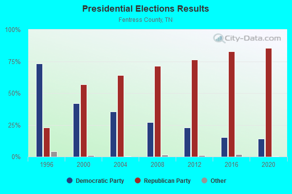
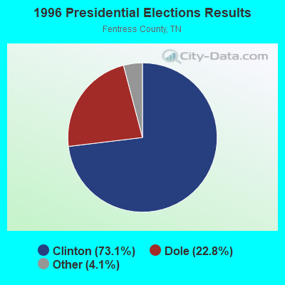
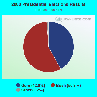

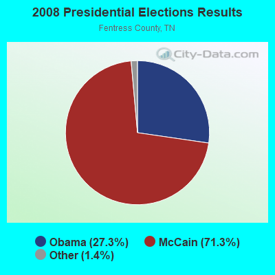
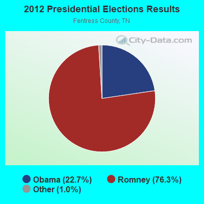

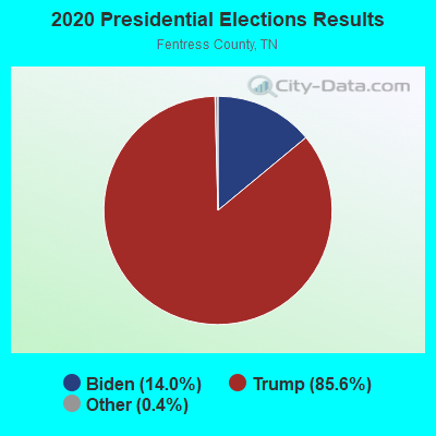
Graphs represent county-level data. Detailed 2008 Election Results
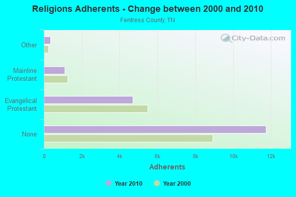
Religion statistics for Manson-Wolf River, TN (based on Fentress County data)
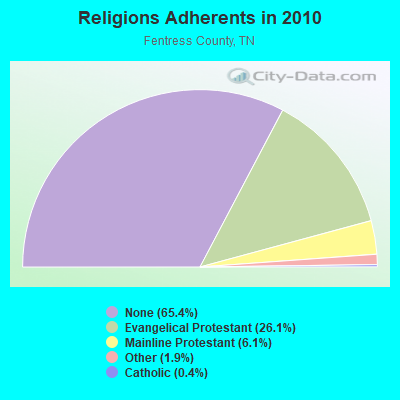
| Religion | Adherents | Congregations |
|---|---|---|
| Evangelical Protestant | 4,691 | 23 |
| Mainline Protestant | 1,099 | 10 |
| Other | 346 | 2 |
| Catholic | 80 | 1 |
| None | 11,743 | - |
Food Environment Statistics:
| Here: | 3.45 / 10,000 pop. |
| Tennessee: | 1.99 / 10,000 pop. |
| This county: | 6.91 / 10,000 pop. |
| State: | 5.16 / 10,000 pop. |
| This county: | 5.76 / 10,000 pop. |
| Tennessee: | 6.56 / 10,000 pop. |
| Fentress County: | 11.5% |
| Tennessee: | 11.4% |
| Fentress County: | 30.0% |
| Tennessee: | 30.2% |
| Fentress County: | 12.3% |
| Tennessee: | 13.5% |
Strongest AM radio stations in Manson-Wolf River:
- WCLC (1260 AM; daytime; 1 kW; JAMESTOWN, TN; Owner: BIBLE BELIEVERS NETWORK, INC.)
- WDEB (1500 AM; daytime; 1 kW; JAMESTOWN, TN; Owner: BAZ BROADCASTING, INC.)
- WKVL (850 AM; daytime; 50 kW; KNOXVILLE, TN; Owner: HORNE RADIO, LLC)
- WSM (650 AM; 50 kW; NASHVILLE, TN; Owner: GAYLORD ENTERTAINMENT COMPANY)
- WWAM (820 AM; daytime; 50 kW; JASPER, TN; Owner: SHELTON BROADCASTING SYSTEM)
- WECO (940 AM; 5 kW; WARTBURG, TN; Owner: MORGAN COUNTY B/CASTING CO.)
- WFLI (1070 AM; 50 kW; LOOKOUT MOUNTAIN, TN; Owner: WFLI, INC.)
- WAMB (1160 AM; 50 kW; DONELSON, TN; Owner: GREAT SOUTHERN BROADCASTING COMPANY, INC.)
- WHAS (840 AM; 50 kW; LOUISVILLE, KY; Owner: CLEAR CHANNEL BROADCASTING LICENSES, INC.)
- WKDA (1200 AM; 50 kW; NASHVILLE, TN; Owner: RADIO NASHVILLE, INC.)
- WLAC (1510 AM; 50 kW; NASHVILLE, TN; Owner: CAPSTAR TX LIMITED PARTNERSHIP)
- WNQM (1300 AM; 50 kW; NASHVILLE, TN; Owner: WNQM. INC.)
- WQBB (1040 AM; daytime; 10 kW; POWELL, TN; Owner: JOURNAL BROADCAST CORPORATION)
Strongest FM radio stations in Manson-Wolf River:
- WDEB-FM (103.9 FM; JAMESTOWN, TN; Owner: BAZ BROADCASTING, INC.)
- WCLC-FM (105.1 FM; JAMESTOWN, TN; Owner: BIBLE BELIEVERS NETWORK, INC.)
- WLQK (95.9 FM; LIVINGSTON, TN; Owner: JWC BROADCASTING)
- WGSQ (94.7 FM; COOKEVILLE, TN; Owner: CLEAR CHANNEL BROADCASTING LICENSES, INC.)
- WDVX (89.9 FM; CLINTON, TN; Owner: CUMBERLAND COMMUNITIES COMMUNI CORP.)
- WLIV-FM (104.7 FM; MONTEREY, TN; Owner: WKXN INC)
- WMKZ (93.1 FM; MONTICELLO, KY; Owner: MONTICELLO-WAYNE COUNTY MEDIA, INC.)
- WOWF (102.5 FM; CROSSVILLE, TN; Owner: PEG BROADCASTING, INC.)
- WECO-FM (101.3 FM; WARTBURG, TN; Owner: MORGAN COUNTY BROADCASTING CO., INC.)
- WKYM (101.7 FM; MONTICELLO, KY; Owner: STEPHEN W. STAPLES JR.)
- WKXD-FM (106.9 FM; MONTEREY, TN; Owner: JWC BROADCASTING)
- WMKW (89.3 FM; CROSSVILLE, TN; Owner: THE MOODY BIBLE INSTITUTE OF CHICAGO)
- WWOG (90.9 FM; COOKEVILLE, TN; Owner: SOMERSET EDUCATIONAL BROADCASTING FOUNDATION)
- WWSR (105.7 FM; ROCKWOOD, TN; Owner: SOUTHERN MEDIA GROUP, INC.)
- WEKX (102.7 FM; JELLICO, TN; Owner: WHITLEY BROADCASTING CO., INC.)
- WBXE (93.7 FM; BAXTER, TN; Owner: JWC BROADCASTING)
TV broadcast stations around Manson-Wolf River:
- WCTE (Channel 22; COOKEVILLE, TN; Owner: UPPER CUMBERLAND BROADCAST COUNCIL)
- WBXX-TV (Channel 20; CROSSVILLE, TN; Owner: ACME TV LICENSES OF TENNESSEE, LLC)

- 28.5%Bottled, tank, or LP gas
- 27.4%Electricity
- 23.8%Wood
- 17.1%Utility gas
- 1.4%Coal or coke
- 1.2%Fuel oil, kerosene, etc.
- 0.7%Other fuel

- 44.5%Wood
- 33.5%Electricity
- 18.3%Bottled, tank, or LP gas
- 3.7%Utility gas
Manson-Wolf River compared to Tennessee state average:
- Median house value below state average.
- Unemployed percentage below state average.
- Black race population percentage significantly below state average.
- Hispanic race population percentage significantly below state average.
- Foreign-born population percentage significantly below state average.
- Renting percentage significantly below state average.
- Length of stay since moving in significantly above state average.
- Number of rooms per house significantly below state average.
- House age significantly below state average.
- Number of college students below state average.
- Percentage of population with a bachelor's degree or higher below state average.