Long Fork, Kentucky
Submit your own pictures of this place and show them to the world
- OSM Map
- General Map
- Google Map
- MSN Map

| Males: 1,286 | |
| Females: 1,313 |
| Median resident age: | 36.8 years |
| Kentucky median age: | 35.9 years |
Zip code: 41572
| Long Fork: | $49,212 |
| KY: | $59,341 |
Estimated per capita income in 2022: $26,740 (it was $14,685 in 2000)
Long Fork CCD income, earnings, and wages data
Estimated median house or condo value in 2022: $99,805 (it was $45,600 in 2000)
| Long Fork: | $99,805 |
| KY: | $196,300 |
Detailed information about poverty and poor residents in Long Fork, KY
Compare current foreclosures near Long Fork, KY:
| Photo | Address | Area | Beds / Baths | Price | Details |
|---|---|---|---|---|---|

|
#1
Red Creek Rd
Pikeville, KY 41501
|
948 sq. feet
|
1 baths 3 beds |
$25,900
|
show details |

|
#2
Chloe Rd
Pikeville, KY 41501
|
1,248 sq. feet
|
1 baths 2 beds |
show details | |

|
#3
Bear Pen Crk
Clintwood, VA 24228
|
967 sq. feet
|
1 baths 2 beds |
show details | |

|
#4
Spruce Pine Br
Banner, KY 41603
|
1,348 sq. feet
|
2 baths 3 beds |
show details | |

|
#5
Ky Route 7
Wayland, KY 41666
|
1,522 sq. feet
|
2 baths 3 beds |
show details | |

|
#6
Cornelia Ave
Whitesburg, KY 41858
|
1,894 sq. feet
|
2 baths 3 beds |
show details | |

|
#7
Parks St
Whitesburg, KY 41858
|
752 sq. feet
|
1 baths 2 beds |
show details | |

|
#8
Marrowbone Creek Rd
Elkhorn City, KY 41522
|
1,188 sq. feet
|
1 baths 3 beds |
show details | |

|
#9
Elkhorn Crk
Shelby Gap, KY 41563
|
1,014 sq. feet
|
1 baths 3 beds |
show details | |

|
#10
Bowling Fork Rd
Elkhorn City, KY 41522
|
1,152 sq. feet
|
1 baths 3 beds |
show details |
| Photo | Address | Area | Beds / Baths | Price | Details |
|---|---|---|---|---|---|

|
#11
N Douglas Ct
Pikeville, KY 41501
|
2,216 sq. feet
|
2 baths 3 beds |
show details | |

|
#12
6th St
Pikeville, KY 41501
|
1,508 sq. feet
|
5 baths 6 beds |
show details | |

|
#13
Highway 160 S
Littcarr, KY 41834
|
2,642 sq. feet
|
1 baths 3 beds |
show details | |

|
#14
Greasy Crk
Shelbiana, KY 41562
|
1,152 sq. feet
|
1 baths 3 beds |
show details | |

|
#15
Little Robinson Creek Btm
Virgie, KY 41572
|
1,000 sq. feet
|
1 baths 3 beds |
show details | |

|
#16
Charlie Bentley Holw
Beaver, KY 41604
|
864 sq. feet
|
1 baths 3 beds |
show details | |

|
#17
Caney Newsome Br
Pikeville, KY 41501
|
1,294 sq. feet
|
2 baths 2 beds |
show details | |

|
#18
Little Robinson Crk
Virgie, KY 41572
|
1,280 sq. feet
|
1 baths 3 beds |
show details | |

|
#19
Shepherds Dr
Garrett, KY 41630
|
1,148 sq. feet
|
1 baths 3 beds |
show details | |

|
#20
Atkins Belcher Rd
Elkhorn City, KY 41522
|
1,924 sq. feet
|
1 baths 2 beds |
show details |
| Photo | Address | Area | Beds / Baths | Price | Details |
|---|---|---|---|---|---|

|
#21
Blaze Br
Jenkins, KY 41537
|
1,600 sq. feet
|
3 baths 3 beds |
show details | |

|
#22
Mullins Addition Dr
Pikeville, KY 41501
|
2,100 sq. feet
|
3 baths 4 beds |
show details | |

|
#23
Helton Hl
Melvin, KY 41650
|
864 sq. feet
|
1 baths 2 beds |
show details | |

|
#24
Circle St
Wheelwright, KY 41669
|
- sq. feet
|
1 baths 3 beds |
show details | |

|
#25
Highway 582
Kite, KY 41828
|
952 sq. feet
|
- baths 2 beds |
show details | |

|
#26
Short Fork Rd
Pippa Passes, KY 41844
|
1,330 sq. feet
|
- baths 2 beds |
show details | |

|
#27
Dry Creek Rd
Topmost, KY 41862
|
864 sq. feet
|
- baths 2 beds |
show details | |

|
#28
S Punkin Ctr
Wayland, KY 41666
|
- sq. feet
|
- baths - beds |
show details | |

|
#29
Highway 7 N
Whitesburg, KY 41858
|
- sq. feet
|
- baths - beds |
show details | |

|
#30
Heritage Dr
Whitesburg, KY 41858
|
- sq. feet
|
- baths - beds |
show details |
| Photo | Address | Area | Beds / Baths | Price | Details |
|---|---|---|---|---|---|

|
#31
Slate Frk
Garner, KY 41817
|
- sq. feet
|
- baths - beds |
show details | |

|
#32
Steer Fork Rd
Mallie, KY 41836
|
708 sq. feet
|
- baths - beds |
show details | |

|
#33
Estill Btm
Wayland, KY 41666
|
- sq. feet
|
- baths - beds |
show details | |

|
#34
Regina Belcher Hwy
Regina, KY 41559
|
- sq. feet
|
- baths - beds |
show details | |

|
#35
Carter Dr
Pikeville, KY 41501
|
- sq. feet
|
- baths - beds |
show details | |

|
#36
Cumberland Ct
Pikeville, KY 41501
|
2,070 sq. feet
|
- baths - beds |
show details | |

|
#37
Blackberry Rd
Mayking, KY 41837
|
- sq. feet
|
- baths - beds |
show details | |

|
#38
Ky Highway 611
Pikeville, KY 41501
|
2,115 sq. feet
|
- baths - beds |
show details | |

|
#39
Hambley Blvd Apt 1010
Pikeville, KY 41501
|
- sq. feet
|
- baths - beds |
show details | |

|
#40
Justice Ln
Pikeville, KY 41501
|
- sq. feet
|
- baths - beds |
show details |
| Photo | Address | Area | Beds / Baths | Price | Details |
|---|---|---|---|---|---|

|
#41
Bruce Elliott Dr
Pikeville, KY 41501
|
- sq. feet
|
- baths - beds |
show details | |

|
#42
Pine Tree Holw
Garner, KY 41817
|
728 sq. feet
|
- baths - beds |
show details | |

|
#43
Draw Bar Holw
Clintwood, VA 24228
|
- sq. feet
|
- baths - beds |
show details | |

|
#44
Low Gap Br
Isom, KY 41824
|
- sq. feet
|
- baths - beds |
show details | |

|
#45
Us Highway 23 S
Pikeville, KY 41501
|
- sq. feet
|
- baths - beds |
show details | |

|
#46
Rocky Loop
Pikeville, KY 41501
|
- sq. feet
|
- baths - beds |
show details | |

|
#47
Adkins Vlg
Banner, KY 41603
|
- sq. feet
|
- baths - beds |
show details | |

|
#48
Ky Route 979
Harold, KY 41635
|
- sq. feet
|
- baths - beds |
show details | |

|
#49
Wolfpen Branch Rd
Shelbiana, KY 41562
|
- sq. feet
|
- baths - beds |
show details | |

|
Check over 1 million property listings on Foreclosure.com!
|
browse all offers | |||

- 2,69099.0%White alone
- 210.8%Hispanic
- 40.1%Asian alone
- 10.04%Black alone
- 10.04%American Indian alone

Races in Long Fork detailed stats: ancestries, foreign born residents, place of birth
 Recent articles from our blog. Our writers, many of them Ph.D. graduates or candidates, create easy-to-read articles on a wide variety of topics.
Current Local Time: EST time zone
Land area: 36.8 square miles.
Population density: 71 people per square mile (very low).

| Long Fork CCD: | 0.9% ($427) |
| Kentucky: | 0.8% ($610) |
Nearest city with pop. 50,000+: Johnson City, TN  (68.7 miles , pop. 55,469).
Nearest city with pop. 200,000+: Fayette, KY (113.1 miles , pop. 260,512).
Nearest city with pop. 1,000,000+: Chicago, IL (412.8 miles , pop. 2,896,016).
Nearest cities:
), ), ), ), ), Latitude: 37.31 N, Longitude: 82.64 W
Area code commonly used in this area: 606


| Here: | 5.3% |
| Kentucky: | 3.8% |

- Mining, quarrying, oil & gas extraction (23.0%)
- Educational services (9.6%)
- Health care (8.5%)
- Professional, scientific, technical services (6.4%)
- Truck transportation (6.2%)
- Construction (4.5%)
- Administrative & support & waste management services (4.3%)

- Mining, quarrying, oil & gas extraction (41.4%)
- Truck transportation (10.0%)
- Construction (6.0%)
- Administrative & support & waste management services (5.6%)
- Public administration (5.2%)
- Repair & maintenance (3.6%)
- Transportation equipment (3.2%)

- Educational services (18.3%)
- Health care (15.7%)
- Professional, scientific, technical services (12.9%)
- Social assistance (8.2%)
- Finance & insurance (7.7%)
- Accommodation & food services (5.2%)
- Real estate & rental & leasing (3.3%)

- Extraction workers (7.1%)
- Driver/sales workers and truck drivers (6.2%)
- Supervisors, construction and extraction workers (5.7%)
- Secretaries and administrative assistants (4.9%)
- Preschool, kindergarten, elementary, and middle school teachers (4.6%)
- Material recording, scheduling, dispatching, and distributing workers (4.4%)
- Other office and administrative support workers, including supervisors (4.0%)

- Extraction workers (13.3%)
- Driver/sales workers and truck drivers (11.4%)
- Supervisors, construction and extraction workers (10.6%)
- Material recording, scheduling, dispatching, and distributing workers (7.0%)
- Other material moving workers, except laborers (5.6%)
- Vehicle and mobile equipment mechanics, installers, and repairers (5.0%)
- Other protective service workers, including supervisors (4.4%)

- Secretaries and administrative assistants (10.5%)
- Counselors, social workers, and other community and social service specialists (8.0%)
- Preschool, kindergarten, elementary, and middle school teachers (7.5%)
- Health technologists and technicians (5.9%)
- Other office and administrative support workers, including supervisors (5.2%)
- Information and record clerks, except customer service representatives (4.9%)
- Cooks and food preparation workers (4.9%)
Average climate in Long Fork, Kentucky
Based on data reported by over 4,000 weather stations


(lower is better)

Air Quality Index (AQI) level in 2022 was 60.7. This is about average.
| City: | 60.7 |
| U.S.: | 72.6 |

Sulfur Dioxide (SO2) [ppb] level in 2002 was 1.08. This is significantly better than average. Closest monitor was 13.6 miles away from the city center.
| City: | 1.08 |
| U.S.: | 1.51 |

Ozone [ppb] level in 2022 was 21.9. This is significantly better than average. Closest monitor was 13.6 miles away from the city center.
| City: | 21.9 |
| U.S.: | 33.3 |

Particulate Matter (PM2.5) [µg/m3] level in 2022 was 6.97. This is about average. Closest monitor was 13.6 miles away from the city center.
| City: | 6.97 |
| U.S.: | 8.11 |
Tornado activity:
Long Fork-area historical tornado activity is significantly below Kentucky state average. It is 77% smaller than the overall U.S. average.
On 5/18/1995, a category F2 (max. wind speeds 113-157 mph) tornado 17.2 miles away from the Long Fork place center caused between $50,000 and $500,000 in damages.
On 4/4/1974, a category F3 (max. wind speeds 158-206 mph) tornado 50.8 miles away from the place center killed one person and injured 4 people and caused between $50,000 and $500,000 in damages.
Earthquake activity:
Long Fork-area historical earthquake activity is significantly above Kentucky state average. It is 26% greater than the overall U.S. average.On 7/27/1980 at 18:52:21, a magnitude 5.2 (5.1 MB, 4.7 MS, 5.0 UK, 5.2 UK, Class: Moderate, Intensity: VI - VII) earthquake occurred 94.5 miles away from Long Fork center
On 8/9/2020 at 12:07:37, a magnitude 5.1 (5.1 MW, Depth: 4.7 mi) earthquake occurred 103.2 miles away from Long Fork center
On 8/23/2011 at 17:51:04, a magnitude 5.8 (5.8 MW, Depth: 3.7 mi) earthquake occurred 261.2 miles away from Long Fork center
On 9/7/1988 at 02:28:09, a magnitude 4.6 (4.5 MB, 4.6 LG, Class: Light, Intensity: IV - V) earthquake occurred 89.0 miles away from Long Fork center
On 11/23/2006 at 10:42:57, a magnitude 4.3 (4.3 MB) earthquake occurred 38.2 miles away from the city center
On 11/2/2006 at 17:53:02, a magnitude 4.3 (4.3 MB, Depth: 0.6 mi) earthquake occurred 40.5 miles away from Long Fork center
Magnitude types: regional Lg-wave magnitude (LG), body-wave magnitude (MB), surface-wave magnitude (MS), moment magnitude (MW)
Natural disasters:
The number of natural disasters in Pike County (38) is a lot greater than the US average (15).Major Disasters (Presidential) Declared: 30
Emergencies Declared: 2
Causes of natural disasters: Floods: 28, Storms: 25, Mudslides: 12, Tornadoes: 9, Landslides: 7, Winter Storms: 4, Fires: 3, Snowstorms: 2, Winds: 2, Blizzard: 1, Flash Flood: 1, Heavy Rain: 1, Hurricane: 1, Snow: 1, Snowfall: 1, Other: 1 (Note: some incidents may be assigned to more than one category).
Hospitals and medical centers near Long Fork:
- PARKVIEW NURSING AND REHABILITATION CENTER (Nursing Home, about 8 miles away; PIKEVILLE, KY)
- HOME CARE HEALTH SERVICES, INC (Home Health Center, about 12 miles away; PIKEVILLE, KY)
- HOSPICE OF PIKE COUNTY (Hospital, about 12 miles away; PIKEVILLE, KY)
- SIGNATURE HEALTHCARE OF PIKEVILLE (Nursing Home, about 13 miles away; PIKEVILLE, KY)
- PIKEVILLE MEDICAL CENTER HOME HEALTH AGENCY (Home Health Center, about 14 miles away; PIKEVILLE, KY)
- PIKEVILLE MEDICAL CENTER Acute Care Hospitals (about 14 miles away; PIKEVILLE, KY)
- FMC - PIKEVILLE (Dialysis Facility, about 14 miles away; PIKEVILLE, KY)
Colleges/universities with over 2000 students nearest to Long Fork:
- Big Sandy Community and Technical College (about 28 miles; Prestonsburg, KY; Full-time enrollment: 2,660)
- Hazard Community and Technical College (about 30 miles; Hazard, KY; FT enrollment: 2,087)
- Southeast Kentucky Community and Technical College (about 31 miles; Cumberland, KY; FT enrollment: 2,196)
- King University (about 57 miles; Bristol, TN; FT enrollment: 2,472)
- Northeast State Community College (about 59 miles; Blountville, TN; FT enrollment: 4,480)
- East Tennessee State University (about 72 miles; Johnson City, TN; FT enrollment: 12,774)
- Morehead State University (about 75 miles; Morehead, KY; FT enrollment: 7,523)
Points of interest:
Notable location: High Camp (A). Display/hide its location on the map
Churches in Long Fork include: Long Fork Church (A), Enterprize Church (B). Display/hide their locations on the map
Cemeteries: Martin Cemetery (1), Little Cemetery (2), Amil Little Cemetery (3), Fleming Memorial Gardens (4), Osborne Cemetery (5), Little Cemetery (6). Display/hide their locations on the map
Streams, rivers, and creeks: Abel Tackett Fork (A), Adams Branch (B), Arnold Fork (C), Bailey Branch (D), Beaver Fork (E), Big Branch (F), Blackburn Branch (G), Bobs Branch (H), Box Fork (I). Display/hide their locations on the map
| This place: | 2.5 people |
| Kentucky: | 2.5 people |
| This place: | 75.2% |
| Whole state: | 66.9% |
| This place: | 4.7% |
| Whole state: | 6.4% |
Likely homosexual households (counted as self-reported same-sex unmarried-partner households)
- Lesbian couples: 0.2% of all households
- Gay men: 0.2% of all households
| This place: | 20.5% |
| Whole state: | 15.8% |
| This place: | 3.6% |
| Whole state: | 6.6% |
For population 15 years and over in Long Fork:

- Never married: 16.2%
- Now married: 67.0%
- Separated: 1.7%
- Widowed: 8.1%
- Divorced: 8.8%
For population 25 years and over in Long Fork:
- High school or higher: 53.0%
- Bachelor's degree or higher: 8.4%
- Graduate or professional degree: 3.3%
- Unemployed: 9.3%
- Mean travel time to work (commute): 33.8 minutes


| Here: | 18.4 |
| Kentucky average: | 13.8 |
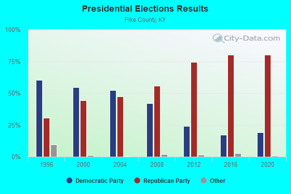
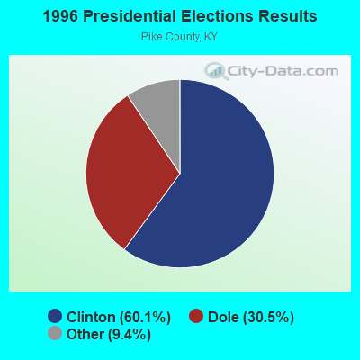
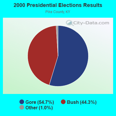
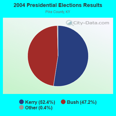
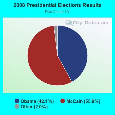
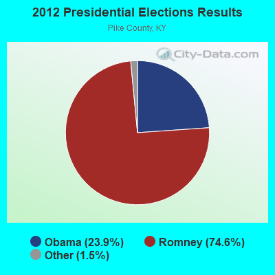
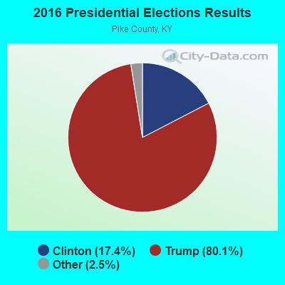
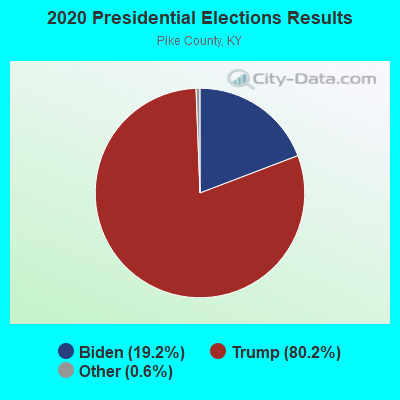
Graphs represent county-level data. Detailed 2008 Election Results
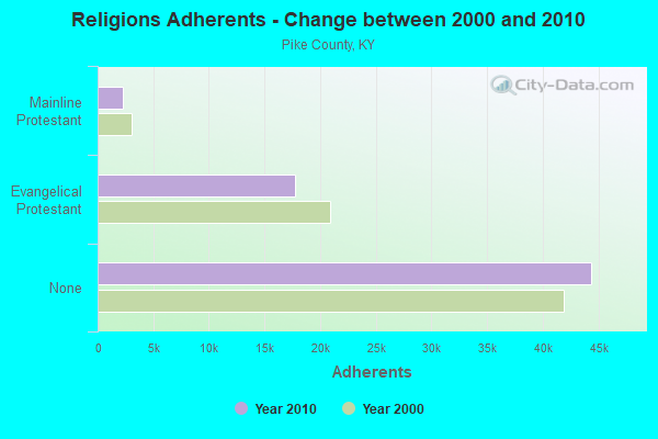
Religion statistics for Long Fork, KY (based on Pike County data)
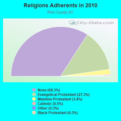
| Religion | Adherents | Congregations |
|---|---|---|
| Evangelical Protestant | 17,720 | 101 |
| Mainline Protestant | 2,227 | 15 |
| Catholic | 293 | 3 |
| Other | 213 | 3 |
| Black Protestant | 180 | 1 |
| None | 44,391 | - |
Food Environment Statistics:
| Pike County: | 3.51 / 10,000 pop. |
| Kentucky: | 2.19 / 10,000 pop. |
| Here: | 0.31 / 10,000 pop. |
| State: | 0.25 / 10,000 pop. |
| Here: | 0.31 / 10,000 pop. |
| State: | 0.74 / 10,000 pop. |
| Pike County: | 3.82 / 10,000 pop. |
| Kentucky: | 4.36 / 10,000 pop. |
| This county: | 4.12 / 10,000 pop. |
| Kentucky: | 5.74 / 10,000 pop. |
| This county: | 15.7% |
| Kentucky: | 11.0% |
| Pike County: | 33.3% |
| State: | 30.0% |
| Pike County: | 13.1% |
| Kentucky: | 15.9% |
Strongest AM radio stations in Long Fork:
- WLSI (900 AM; 5 kW; PIKEVILLE, KY; Owner: EAST KENTUCKY BROADCASTING CORPORATION)
- WEZC (1480 AM; daytime; 5 kW; NEON, KY; Owner: JESUS COMMUNICATION ILNC.)
- WTCW (920 AM; 4 kW; WHITESBURG, KY; Owner: T.C.W. BROADCASTING , INC.)
- WBPA (1460 AM; 5 kW; ELKHORN CITY, KY; Owner: EAST KENTUCKY BROADCASTING CORP)
- WDIC (1430 AM; daytime; 5 kW; CLINCHCO, VA; Owner: DICKENSON COUNTY BROADCASTING CORP.)
- WKVG (1000 AM; daytime; 1 kW; JENKINS, KY; Owner: MARTINS & ASSOCIATES, INC.)
- WPRT (960 AM; 5 kW; PRESTONSBURG, KY; Owner: EAST KENTUCKY RADIO NETWORK, INC.)
- WNVA (1350 AM; 5 kW; NORTON, VA; Owner: RADIO-WISE, INC.)
- WKYH (600 AM; 5 kW; PAINTSVILLE, KY; Owner: HIGHLANDS BROADCASTING CORPORATION)
- WNRG (940 AM; 5 kW; GRUNDY, VA; Owner: VIRGINIA-KENTUCKY BROADCASTING CO., INC)
- WDOC (1310 AM; 5 kW; PRESTONSBURG, KY)
- WZAP (690 AM; 10 kW; BRISTOL, VA; Owner: RAM COMMUNICATIONS, INC.)
- WGOC (640 AM; 10 kW; BLOUNTVILLE, TN; Owner: CITADEL BROADCASTING COMPANY)
Strongest FM radio stations in Long Fork:
- WZLK (107.5 FM; VIRGIE, KY; Owner: EAST KENTUCKY BROADCASTING CORPORATION)
- WDXC (102.3 FM; POUND, VA; Owner: WDXC RADIO, INC.)
- WIFX-FM (94.3 FM; JENKINS, KY; Owner: LETCHER COUNTY BROADCASTING, INC)
- WXKQ-FM (103.9 FM; WHITESBURG, KY; Owner: T.C.W. BROADCASTING , INC.)
- WMMT (88.7 FM; WHITESBURG, KY; Owner: APPALSHOP, INCORPORATED)
- WPKE-FM (103.1 FM; COAL RUN, KY; Owner: EAST KENTUCKY BROADCASTING CORP.)
- WDHR (93.1 FM; PIKEVILLE, KY; Owner: EAST KENTUCKY BROADCASTING CORP.)
- WXLR (104.9 FM; HAROLD, KY; Owner: ADAM D GEARHEART)
- WSEH (102.7 FM; CUMBERLAND, KY; Owner: CUMBERLAND CITY BROADCASTING, INC.)
- WAXM (93.5 FM; BIG STONE GAP, VA; Owner: VALLEY BROADCASTING, INC.)
- WWJD (91.7 FM; PIPPA PASSES, KY; Owner: ALICE LLOYD COLLEGE)
- WJSO (90.1 FM; PIKEVILLE, KY; Owner: THE MOODY BIBLE INSTITUTE OF CHICAGO)
- WSGS (101.1 FM; HAZARD, KY; Owner: MOUNTAIN BROADCASTING SERVICE, INC.)
- W251AI (98.1 FM; PIKEVILLE, KY; Owner: EAST KENTUCKY BROADCASTING CORPORATION)
- WKCB-FM (107.1 FM; HINDMAN, KY; Owner: HINDMAN BROADCASTING CORPORATION)
- W223AA (92.5 FM; BIG STONE GAP, VA; Owner: VALLEY BROADCASTING, INC.)
- WZQQ (97.9 FM; HYDEN, KY; Owner: LESLIE COUNTY BROADCASTING, INC.)
- WQHY (95.5 FM; PRESTONSBURG, KY; Owner: WDOC, INC.)
- WJMD (104.7 FM; HAZARD, KY; Owner: HAZARD BROADCASTING SERVICES)
- WDIC-FM (92.1 FM; CLINCHCO, VA; Owner: DICKENSON COUNTY BROADCASTING CORP.)
TV broadcast stations around Long Fork:
- WYMT-TV (Channel 57; HAZARD, KY; Owner: WYMT LICENSEE CORP.)
- W24BT (Channel 24; TALBERT, KY; Owner: MS COMMUNICATIONS, LLC)
- WKPI-TV (Channel 22; PIKEVILLE, KY; Owner: KENTUCKY AUTHORITY FOR EDUCATIONAL TV)
- W26BK (Channel 26; TALBERT, KY; Owner: MS COMMUNICATIONS, LLC)
- W16BI (Channel 16; TALBERT, KY; Owner: MS COMMUNICATIONS, LLC)
- W31BU (Channel 31; TALBERT, KY; Owner: MS COMMUNICATIONS, LLC)
- W53BQ (Channel 53; TALBERT, KY; Owner: MS COMMUNICATIONS, LLC)
- W69ED (Channel 69; TALBERT, KY; Owner: MS COMMUNICATIONS, LLC)
- WKHA (Channel 35; HAZARD, KY; Owner: KENTUCKY AUTHORITY FOR EDUCATIONAL TV)

- 67.7%Electricity
- 22.3%Utility gas
- 5.6%Coal or coke
- 2.0%Fuel oil, kerosene, etc.
- 1.2%Bottled, tank, or LP gas
- 1.2%Wood

- 55.6%Utility gas
- 33.1%Electricity
- 8.1%Coal or coke
- 3.1%Bottled, tank, or LP gas
Long Fork compared to Kentucky state average:
- Median house value below state average.
- Black race population percentage significantly below state average.
- Hispanic race population percentage significantly below state average.
- Median age below state average.
- Foreign-born population percentage significantly below state average.
- Renting percentage below state average.
- Length of stay since moving in significantly above state average.
- Number of rooms per house significantly below state average.
- House age significantly below state average.
- Number of college students below state average.
- Percentage of population with a bachelor's degree or higher significantly below state average.