Little River, Georgia
Submit your own pictures of this place and show them to the world
- OSM Map
- General Map
- Google Map
- MSN Map

| Males: 2,348 | |
| Females: 2,364 |
| Median resident age: | 43.0 years |
| Georgia median age: | 33.4 years |
Zip code: 31024
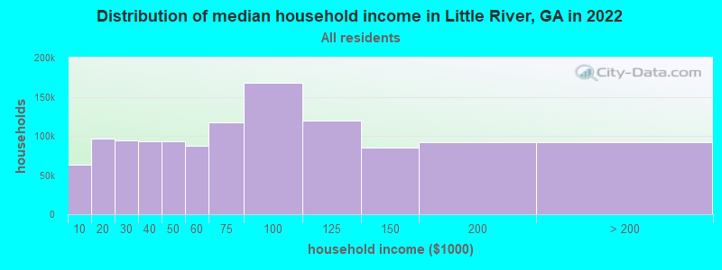
| Little River: | $69,519 |
| GA: | $72,837 |
Estimated per capita income in 2022: $50,326 (it was $23,554 in 2000)
Little River CCD income, earnings, and wages data
Estimated median house or condo value in 2022: $270,878 (it was $92,100 in 2000)
| Little River: | $270,878 |
| GA: | $297,400 |
Detailed information about poverty and poor residents in Little River, GA


- 3,65883.4%White alone
- 62114.2%Black alone
- 431.0%Hispanic
- 230.5%Two or more races
- 190.4%Asian alone
- 140.3%American Indian alone
- 70.2%Native Hawaiian and Other
Pacific Islander alone - 10.02%Other race alone

Races in Little River detailed stats: ancestries, foreign born residents, place of birth
 Recent articles from our blog. Our writers, many of them Ph.D. graduates or candidates, create easy-to-read articles on a wide variety of topics.
Current Local Time: EST time zone
Elevation: 420 feet
Land area: 108.4 square miles.
Population density: 43 people per square mile (very low).

| Little River CCD: | 0.8% ($695) |
| Georgia: | 0.9% ($919) |
Nearest city with pop. 50,000+: Macon, GA  (29.4 miles , pop. 97,255).
Nearest city with pop. 200,000+: Atlanta, GA (69.4 miles , pop. 416,474).
Nearest city with pop. 1,000,000+: Chicago, IL (641.1 miles , pop. 2,896,016).
Nearest cities:
), ), ), ), ), )Latitude: 33.21 N, Longitude: 83.39 W

| Here: | 3.6% |
| Georgia: | 2.9% |
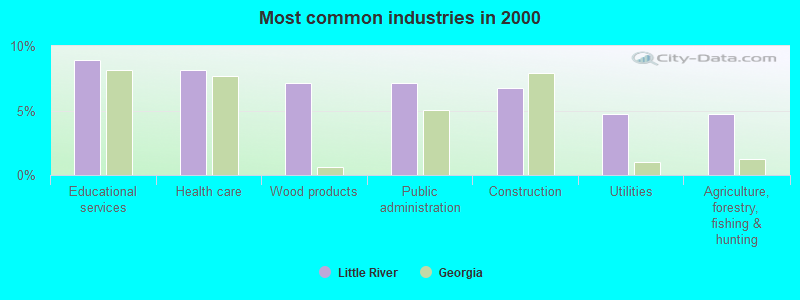
- Educational services (8.9%)
- Health care (8.1%)
- Wood products (7.2%)
- Public administration (7.2%)
- Construction (6.7%)
- Utilities (4.7%)
- Agriculture, forestry, fishing & hunting (4.7%)
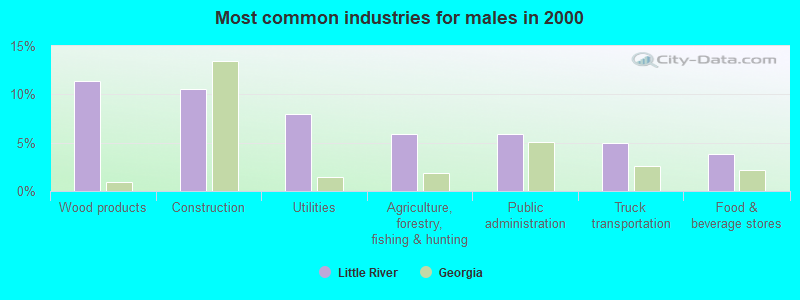
- Wood products (11.4%)
- Construction (10.6%)
- Utilities (8.0%)
- Agriculture, forestry, fishing & hunting (5.9%)
- Public administration (5.9%)
- Truck transportation (5.0%)
- Food & beverage stores (3.9%)
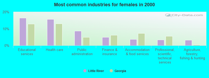
- Educational services (16.4%)
- Health care (15.6%)
- Public administration (8.7%)
- Finance & insurance (5.0%)
- Accommodation & food services (3.7%)
- Professional, scientific, technical services (3.4%)
- Agriculture, forestry, fishing & hunting (3.2%)
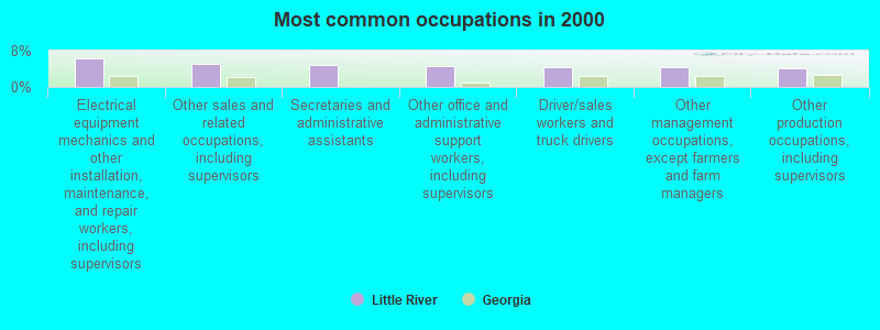
- Electrical equipment mechanics and other installation, maintenance, and repair workers, including supervisors (6.2%)
- Other sales and related occupations, including supervisors (5.2%)
- Secretaries and administrative assistants (4.9%)
- Other office and administrative support workers, including supervisors (4.5%)
- Driver/sales workers and truck drivers (4.5%)
- Other management occupations, except farmers and farm managers (4.4%)
- Other production occupations, including supervisors (4.1%)
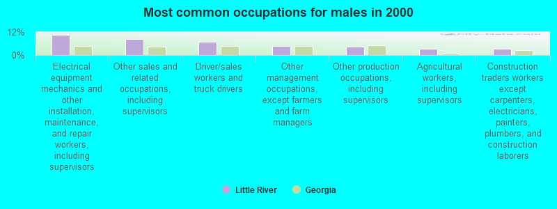
- Electrical equipment mechanics and other installation, maintenance, and repair workers, including supervisors (10.4%)
- Other sales and related occupations, including supervisors (8.4%)
- Driver/sales workers and truck drivers (6.8%)
- Other management occupations, except farmers and farm managers (4.9%)
- Other production occupations, including supervisors (4.4%)
- Agricultural workers, including supervisors (3.4%)
- Construction traders workers except carpenters, electricians, painters, plumbers, and construction laborers (3.4%)

- Secretaries and administrative assistants (11.0%)
- Other office and administrative support workers, including supervisors (8.7%)
- Preschool, kindergarten, elementary, and middle school teachers (6.1%)
- Registered nurses (4.2%)
- Other management occupations, except farmers and farm managers (3.9%)
- Other production occupations, including supervisors (3.9%)
- Sales representatives, services, wholesale and manufacturing (3.6%)
Average climate in Little River, Georgia
Based on data reported by over 4,000 weather stations


(lower is better)
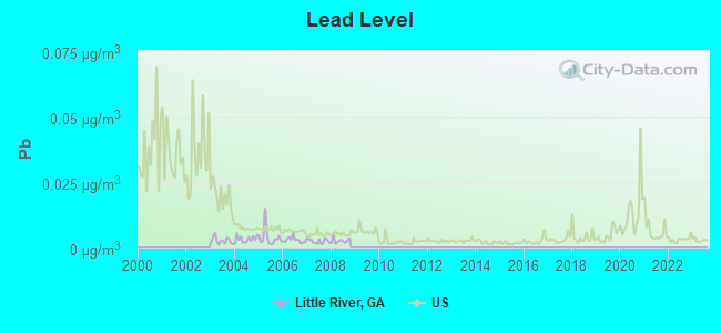
Lead (Pb) [µg/m3] level in 2008 was 0.00262. This is significantly better than average. Closest monitor was 10.0 miles away from the city center.
| City: | 0.00262 |
| U.S.: | 0.00931 |
Tornado activity:
Little River-area historical tornado activity is slightly below Georgia state average. It is 8% greater than the overall U.S. average.
On 11/22/1992, a category F4 (max. wind speeds 207-260 mph) tornado 4.1 miles away from the Little River place center killed 5 people and injured 86 people and caused between $5,000,000 and $50,000,000 in damages.
On 4/30/1953, a category F4 tornado 44.2 miles away from the place center killed 18 people and injured 300 people and caused between $5,000,000 and $50,000,000 in damages.
Earthquake activity:
Little River-area historical earthquake activity is significantly above Georgia state average. It is 13% greater than the overall U.S. average.On 8/2/1974 at 08:52:09, a magnitude 4.9 (4.3 MB, 4.9 LG, Class: Light, Intensity: IV - V) earthquake occurred 69.2 miles away from the city center
On 4/29/2003 at 08:59:39, a magnitude 4.9 (4.4 MB, 4.6 MW, 4.9 LG) earthquake occurred 156.0 miles away from the city center
On 4/29/2003 at 08:59:39, a magnitude 4.6 (4.6 MW, Depth: 12.3 mi) earthquake occurred 156.0 miles away from Little River center
On 11/30/1973 at 07:48:41, a magnitude 4.7 (4.7 MB, 4.6 ML) earthquake occurred 181.7 miles away from Little River center
On 8/9/2020 at 12:07:37, a magnitude 5.1 (5.1 MW, Depth: 4.7 mi, Class: Moderate, Intensity: VI - VII) earthquake occurred 260.6 miles away from Little River center
On 11/22/1974 at 05:25:55, a magnitude 4.7 (4.7 MB) earthquake occurred 189.5 miles away from Little River center
Magnitude types: regional Lg-wave magnitude (LG), body-wave magnitude (MB), local magnitude (ML), moment magnitude (MW)
Natural disasters:
The number of natural disasters in Putnam County (8) is smaller than the US average (15).Major Disasters (Presidential) Declared: 3
Emergencies Declared: 3
Causes of natural disasters: Hurricanes: 2, Tornadoes: 2, Winds: 2, Drought: 1, Heavy Rain: 1, Storm: 1, Tropical Storm: 1, Winter Storm: 1, Other: 1 (Note: some incidents may be assigned to more than one category).
Hospitals and medical centers near Little River:
- ORMC/ HOSPICE OF THE OCONEE (Hospital, about 13 miles away; MILLEDGEVILLE, GA)
- OCONEE REG MC SKILLED NSG UNIT (Nursing Home, about 13 miles away; MILLEDGEVILLE, GA)
- OCONEE DIALYSIS CENTER (Dialysis Facility, about 13 miles away; MILLEDGEVILLE, GA)
- ABC HOME HEALTH OF MILLEDGEVILLE (Home Health Center, about 13 miles away; MILLEDGEVILLE, GA)
- MEDICAL KIDNEY SERVICES OF CENTRAL GEORGIA, LTD (Dialysis Facility, about 13 miles away; MILLEDGEVILLE, GA)
- DSI MILLEDGEVILLE DIALYSIS (Dialysis Facility, about 14 miles away; MILLEDGEVILLE, GA)
- DAVITA INC MILLEDGEVILLE (Dialysis Facility, about 14 miles away; MILLEDGEVILLE, GA)
Colleges/universities with over 2000 students nearest to Little River:
- Georgia College and State University (about 14 miles; Milledgeville, GA; Full-time enrollment: 6,271)
- Georgia Military College-Distance Learning Campuses (about 14 miles; Milledgeville, GA; FT enrollment: 6,438)
- Mercer University (about 31 miles; Macon, GA; FT enrollment: 6,297)
- Middle Georgia State College (about 35 miles; Macon, GA; FT enrollment: 7,091)
- Gordon State College (about 46 miles; Barnesville, GA; FT enrollment: 3,336)
- Central Georgia Technical College (about 49 miles; Warner Robins, GA; FT enrollment: 6,829)
- University of Georgia (about 52 miles; Athens, GA; FT enrollment: 32,679)
Points of interest:
Notable locations in Little River: Cedar Creek Check Station (A), Mathis Hunt Camp (B), Twin Bridges Hunt Camp (C), Murder Creek Falls Hunt Camp (D), Rock Creek Hunt Camp (E), Willard Hunt Camp (F), Murder Creek Research Natural Area (G), Oak Grove Hunt Camp (H), Culp Hunt Camp (I), Murder Creek Hunt Camp (J), Lazenberry Hunt Camp (K), Sinclair Lake Recreation Area (L), Twin Bridges Fire Department (M), Harllee Branch Power Plant (N). Display/hide their locations on the map
Churches in Little River include: Pierces Chapel Church (A), Central Church (B), Pleasant Grove Church (C), Lake Shore Church (D), Raymouth Church (E), Reids Chapel (F), Friendship Church (G), Mount Ararat Church (H), Mount Calvin Church (I). Display/hide their locations on the map
Cemetery: Key Cemetery (1). Display/hide its location on the map
Streams, rivers, and creeks: Little Creek (A), Potato Creek (B), Murder Creek (C), Cold Branch (D), Blue Branch (E), Hitchcock Branch (F), Bear Creek (G), Baker Branch (H), Big Cedar Creek (I). Display/hide their locations on the map
Park in Little River: Cedar Creek Wildlife Management Area (1). Display/hide its location on the map
| This place: | 2.4 people |
| Georgia: | 2.6 people |
| This place: | 70.8% |
| Whole state: | 68.5% |
| This place: | 5.9% |
| Whole state: | 5.9% |
Likely homosexual households (counted as self-reported same-sex unmarried-partner households)
- Lesbian couples: 0.5% of all households
- Gay men: 0.2% of all households
| This place: | 7.8% |
| Whole state: | 13.0% |
| This place: | 4.0% |
| Whole state: | 6.1% |
For population 15 years and over in Little River:
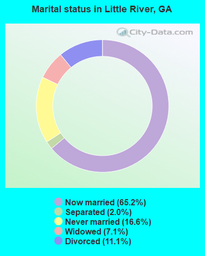
- Never married: 16.6%
- Now married: 65.2%
- Separated: 2.0%
- Widowed: 7.1%
- Divorced: 11.1%
For population 25 years and over in Little River:
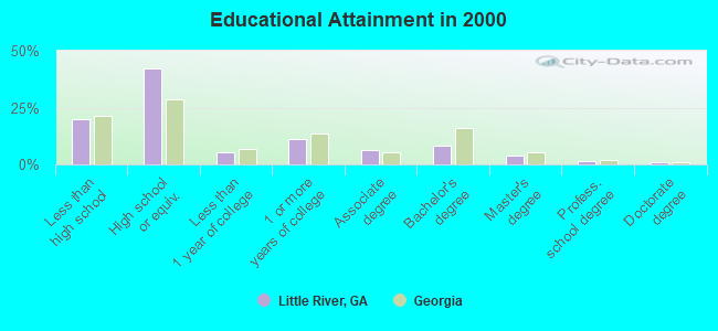
- High school or higher: 80.0%
- Bachelor's degree or higher: 14.8%
- Graduate or professional degree: 6.6%
- Unemployed: 3.6%
- Mean travel time to work (commute): 30.6 minutes
| Here: | 11.7 |
| Georgia average: | 13.3 |
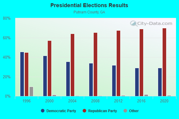
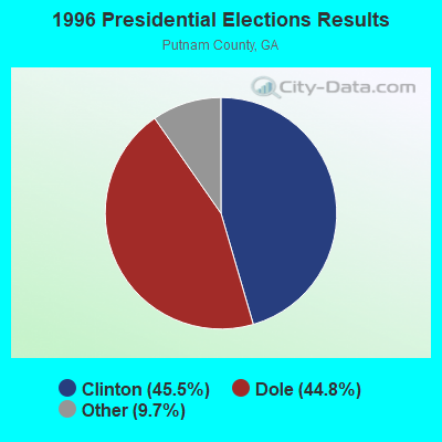
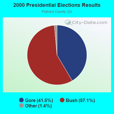

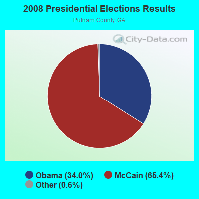


Graphs represent county-level data. Detailed 2008 Election Results
Religion statistics for Little River, GA (based on Putnam County data)

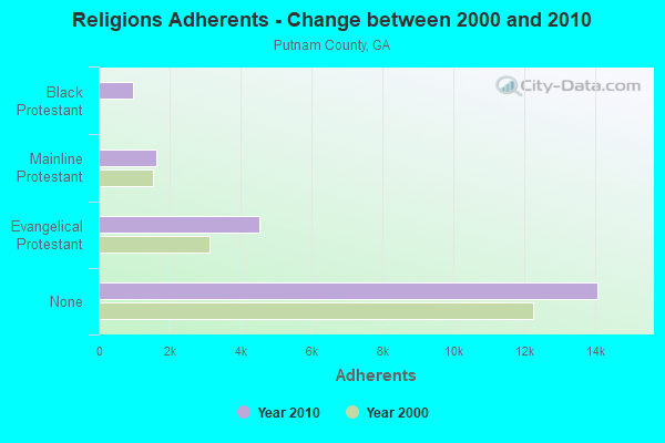
| Religion | Adherents | Congregations |
|---|---|---|
| Evangelical Protestant | 4,542 | 23 |
| Mainline Protestant | 1,620 | 11 |
| Black Protestant | 964 | 6 |
| Other | 18 | 1 |
| None | 14,074 | - |
Food Environment Statistics:
| Putnam County: | 1.49 / 10,000 pop. |
| State: | 1.91 / 10,000 pop. |
| Putnam County: | 0.50 / 10,000 pop. |
| Georgia: | 0.15 / 10,000 pop. |
| This county: | 9.91 / 10,000 pop. |
| State: | 5.12 / 10,000 pop. |
| Putnam County: | 8.43 / 10,000 pop. |
| State: | 7.41 / 10,000 pop. |
| Putnam County: | 12.5% |
| State: | 10.4% |
| Here: | 29.1% |
| Georgia: | 27.8% |
| Putnam County: | 14.2% |
| Georgia: | 14.6% |
Strongest AM radio stations in Little River:
- WMAC (940 AM; 50 kW; MACON, GA; Owner: CUMULUS LICENSING CORP.)
- WSB (750 AM; 50 kW; ATLANTA, GA; Owner: CXR HOLDINGS, INC.)
- WGST (640 AM; 50 kW; ATLANTA, GA; Owner: CITICASTERS LICENSES, L.P.)
- WXJO (1120 AM; daytime; 10 kW; GORDON, GA; Owner: ROBERTS COMMUNICATIONS, INC.)
- WCNN (680 AM; 50 kW; NORTH ATLANTA, GA; Owner: DICKEY BROADCASTING COMPANY)
- WGUN (1010 AM; 50 kW; ATLANTA, GA; Owner: WGUN, INC.)
- WKVQ (1520 AM; daytime; 1 kW; EATONTON, GA; Owner: CRAIG BAKER)
- WQXI (790 AM; 28 kW; ATLANTA, GA; Owner: JEFFERSON-PILOT COMMUNICATIONS COMPANY OF GEORGIA)
- WAOK (1380 AM; 50 kW; ATLANTA, GA; Owner: INFINITY BROADCASTING OPERATIONS, INC.)
- WMLB (1160 AM; 50 kW; EAST POINT, GA; Owner: ATLANTA AREA BROADCASTING, INC.)
- WNNG (1350 AM; 15 kW; WARNER ROBINS, GA; Owner: CHASE BROADCASTING, INC.)
- WFTD (1080 AM; daytime; 50 kW; MARIETTA, GA; Owner: PRIETO ENTERPRISES, INC.)
- WAZX (1550 AM; 50 kW; SMYRNA, GA; Owner: GA-MEX BROADCASTING, INC.)
Strongest FM radio stations in Little River:
- WMGZ (97.7 FM; EATONTON, GA; Owner: MIDDLE GEORGIA COMMUNICATIONS, INC.)
- WKZR (102.3 FM; MILLEDGEVILLE, GA; Owner: WMVG, INC.)
- WLRR (100.7 FM; MILLEDGEVILLE, GA; Owner: PRESTON W. SMALL)
- WPMA (102.7 FM; BUCKHEAD, GA; Owner: BARINOWSKI INVESTMENT COMPANY, L.P.)
- WFSH-FM (104.7 FM; ATHENS, GA; Owner: SOUTH TEXAS BROADCASTING, INC.)
- WFXM (107.1 FM; GORDON, GA; Owner: ROBERTS COMMUNICATIONS, INC.)
- WYNF (96.5 FM; GRAY, GA; Owner: CLEVELAND RADIO LICENSES, LLC)
- WAYS (105.5 FM; MACON, GA; Owner: CUMULUS LICENSING CORP.)
- WPEZ (93.7 FM; JEFFERSONVILLE, GA; Owner: CUMULUS LICENSING CORP.)
- WDEN-FM (99.1 FM; MACON, GA; Owner: CUMULUS LICENSING CORP.)
- WDDK (103.9 FM; GREENSBORO, GA; Owner: BRIARPATCH RADIO INC.)
- WQMJ (100.1 FM; FORSYTH, GA; Owner: ROBERTS COMMUNICATIONS, INC.)
- W201BN (88.1 FM; MILLEDGEVILLE, GA; Owner: CALVARY CHAPEL OF TWIN FALLS, INC.)
- WGUR (88.9 FM; MILLEDGEVILLE, GA; Owner: GEORGIA COLLEGE & STATE UNIVERSITY)
TV broadcast stations around Little River:
- WDMA-LP (Channel 32; MACON, GA; Owner: WORD OF GOD FELLOWSHIP, INC.)
- WPGA-TV (Channel 58; PERRY, GA; Owner: RADIO PERRY, INC.)
- WMGT-TV (Channel 41; MACON, GA; Owner: MORRIS NETWORK, INC.)
- WMAZ-TV (Channel 13; MACON, GA; Owner: GANNETT GEORGIA, L.P.)
- WGXA (Channel 24; MACON, GA; Owner: PIEDMONT TELEVISION OF MACON LICENSE LLC)
- WGNM (Channel 64; MACON, GA; Owner: GOOD NEWS TELEVISION)
- National Bridge Inventory (NBI) Statistics
- 1Number of bridges
- 16ft / 4.6mTotal length
- $891,000Total costs
- 340Total average daily traffic
- 30Total average daily truck traffic
- 510Total future (year 2031) average daily traffic

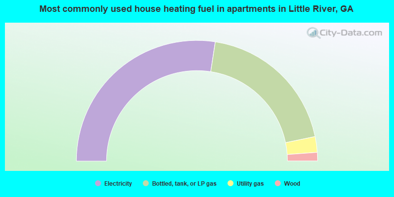
- 56.1%Electricity
- 38.0%Bottled, tank, or LP gas
- 4.2%Utility gas
- 1.3%Wood
- 0.4%Fuel oil, kerosene, etc.
- 54.8%Electricity
- 38.6%Bottled, tank, or LP gas
- 4.2%Utility gas
- 2.3%Wood
Little River compared to Georgia state average:
- Unemployed percentage significantly below state average.
- Black race population percentage below state average.
- Hispanic race population percentage significantly below state average.
- Foreign-born population percentage significantly below state average.
- Renting percentage below state average.
- Length of stay since moving in significantly above state average.
- Number of rooms per house significantly below state average.
- House age significantly below state average.
- Percentage of population with a bachelor's degree or higher below state average.