Little Missouri, Montana
Submit your own pictures of this place and show them to the world
- OSM Map
- General Map
- Google Map
- MSN Map

| Males: 227 | |
| Females: 217 |
| Median resident age: | 40.8 years |
| Montana median age: | 37.5 years |
Zip code: 59311
| Little Missouri: | $53,164 |
| MT: | $67,631 |
Estimated per capita income in 2022: $27,906 (it was $12,692 in 2000)
Little Missouri CCD income, earnings, and wages data
Estimated median house or condo value in 2022: $447,411 (it was $137,500 in 2000)
| Little Missouri: | $447,411 |
| MT: | $366,400 |
Mean prices in 2022: all housing units: $775,970; detached houses: $983,408; mobile homes: $114,211
Little Missouri, MT residents, houses, and apartments details
Detailed information about poverty and poor residents in Little Missouri, MT
Compare current foreclosures near your location:
| Photo | Address | Area | Beds / Baths | Price | Details |
|---|---|---|---|---|---|

|
#1
N Rhodes St
Pretty Prairie, KS 67570
|
1,725 sq. feet
|
2 baths 4 beds |
show details | |

|
#2
W 21st St N
Cheney, KS 67025
|
3,190 sq. feet
|
3 baths 5 beds |
show details | |

|
#3
NE Waterloo Ave
Murdock, KS 67111
|
1,220 sq. feet
|
1 baths 3 beds |
show details | |

|
#4
E Arlington Rd
Haven, KS 67543
|
960 sq. feet
|
1 baths 2 beds |
show details | |

|
#5
E Winterset St
Goddard, KS 67052
|
816 sq. feet
|
1 baths 2 beds |
show details | |

|
#6
W 39th St S
Goddard, KS 67052
|
4,221 sq. feet
|
3 baths 3 beds |
show details | |

|
#7
E 4th Ave Apt 1
Cheney, KS 67025
|
- sq. feet
|
- baths - beds |
show details | |

|
#8
SE Viney Ave
Murdock, KS 67111
|
- sq. feet
|
- baths - beds |
show details | |

|
#9
W Main St
Mount Hope, KS 67108
|
- sq. feet
|
- baths - beds |
show details | |

|
#10
N 189th Cir W
Colwich, KS 67030
|
- sq. feet
|
- baths - beds |
show details |
| Photo | Address | Area | Beds / Baths | Price | Details |
|---|---|---|---|---|---|

|
#11
N Main St
Goddard, KS 67052
|
- sq. feet
|
- baths - beds |
show details | |

|
#12
Martens Ct
Goddard, KS 67052
|
- sq. feet
|
- baths - beds |
show details | |

|
#13
W Maple St Lot D
Goddard, KS 67052
|
- sq. feet
|
- baths - beds |
show details | |

|
#14
S 339th St W
Cheney, KS 67025
|
- sq. feet
|
- baths - beds |
show details | |

|
#15
E Casey Dr
Goddard, KS 67052
|
- sq. feet
|
- baths - beds |
show details | |

|
Check over 1 million property listings on Foreclosure.com!
|
browse all offers | |||

- 47397.7%White alone
- 30.6%American Indian alone
- 30.6%Two or more races
- 30.6%Hispanic
- 20.4%Asian alone

Races in Little Missouri detailed stats: ancestries, foreign born residents, place of birth
 Recent articles from our blog. Our writers, many of them Ph.D. graduates or candidates, create easy-to-read articles on a wide variety of topics.
Current Local Time: MST time zone
Land area: 2289.6 square miles.
Population density: 0.2 people per square mile (very low).

| Little Missouri CCD: | 0.7% ($900) |
| Montana: | 1.3% ($1,212) |
Nearest city with pop. 50,000+: Rapid City, SD  (107.3 miles , pop. 59,607).
Nearest city with pop. 200,000+: West Adams, CO (378.7 miles , pop. 259,628).
Nearest city with pop. 1,000,000+: Chicago, IL (874.8 miles , pop. 2,896,016).
Nearest cities:
), ), ), )Latitude: 45.34 N, Longitude: 104.50 W


| Here: | 2.2% |
| Montana: | 3.8% |

- Agriculture, forestry, fishing & hunting (78.5%)
- Construction (3.9%)
- Mining, quarrying, oil & gas extraction (2.9%)
- Educational services (2.9%)
- Health care (2.5%)
- Accommodation & food services (2.5%)
- Department & other general merchandise stores (1.1%)

- Agriculture, forestry, fishing & hunting (86.1%)
- Construction (5.4%)
- Mining, quarrying, oil & gas extraction (4.8%)
- Other transportation, support activities, couriers (1.2%)
- Health care (1.2%)
- Arts, entertainment, recreation (1.2%)

- Agriculture, forestry, fishing & hunting (67.3%)
- Educational services (7.1%)
- Accommodation & food services (6.2%)
- Health care (4.4%)
- Department & other general merchandise stores (2.7%)
- Metals & minerals, except petroleum, merchant wholesalers (1.8%)
- Construction (1.8%)

- Farmers and farm managers (68.5%)
- Agricultural workers, including supervisors (5.4%)
- Information and record clerks, except customer service representatives (2.5%)
- Other management occupations, except farmers and farm managers (2.5%)
- Carpenters (1.8%)
- Preschool, kindergarten, elementary, and middle school teachers (1.4%)
- Building and grounds cleaning and maintenance occupations (1.4%)

- Farmers and farm managers (80.7%)
- Agricultural workers, including supervisors (3.0%)
- Other management occupations, except farmers and farm managers (1.8%)
- Fishing, hunting, and forestry occupations (1.8%)
- Carpenters (1.8%)
- Electricians (1.8%)
- Driver/sales workers and truck drivers (1.8%)

- Farmers and farm managers (50.4%)
- Agricultural workers, including supervisors (8.8%)
- Information and record clerks, except customer service representatives (6.2%)
- Preschool, kindergarten, elementary, and middle school teachers (3.5%)
- Other management occupations, except farmers and farm managers (3.5%)
- Building and grounds cleaning and maintenance occupations (3.5%)
- Material recording, scheduling, dispatching, and distributing workers (3.5%)
Average climate in Little Missouri, Montana
Based on data reported by over 4,000 weather stations


Tornado activity:
Little Missouri-area historical tornado activity is significantly above Montana state average. It is 79% smaller than the overall U.S. average.
On 7/7/1969, a category F4 (max. wind speeds 207-260 mph) tornado 36.6 miles away from the Little Missouri place center caused between $5000 and $50,000 in damages.
On 7/18/1963, a category F3 (max. wind speeds 158-206 mph) tornado 57.7 miles away from the place center caused between $50,000 and $500,000 in damages.
Earthquake activity:
Little Missouri-area historical earthquake activity is significantly above Montana state average. It is 271% greater than the overall U.S. average.On 8/18/1959 at 06:37:13, a magnitude 7.7 (7.7 UK, Class: Major, Intensity: VIII - XII) earthquake occurred 306.0 miles away from Little Missouri center, causing $26,000,000 total damage
On 10/28/1983 at 14:06:06, a magnitude 7.3 (6.2 MB, 7.3 MS, 7.0 MW) earthquake occurred 465.3 miles away from Little Missouri center, causing 2 deaths (2 shaking deaths) and 3 injuries, causing $15,000,000 total damage
On 9/8/1984 at 00:59:31, a magnitude 5.1 (5.1 MB, Class: Moderate, Intensity: VI - VII) earthquake occurred 103.9 miles away from the city center
On 6/30/1975 at 18:54:13, a magnitude 6.1 (5.6 MB, 5.9 MS, 6.1 UK, 6.1 ML, Class: Strong, Intensity: VII - IX) earthquake occurred 308.4 miles away from Little Missouri center
On 5/29/1984 at 20:18:32, a magnitude 5.0 (5.0 MB) earthquake occurred 105.0 miles away from the city center
On 10/18/1984 at 15:30:23, a magnitude 5.5 (5.4 MB, 5.1 MS, 5.5 ML) earthquake occurred 210.4 miles away from Little Missouri center
Magnitude types: body-wave magnitude (MB), local magnitude (ML), surface-wave magnitude (MS), moment magnitude (MW)
Natural disasters:
The number of natural disasters in Carter County (7) is smaller than the US average (15).Major Disasters (Presidential) Declared: 5
Emergencies Declared: 1
Causes of natural disasters: Floods: 2, Storms: 2, Winter Storms: 2, Fire: 1, Hurricane: 1, Wind: 1, Other: 1 (Note: some incidents may be assigned to more than one category).
Colleges/universities with over 2000 students nearest to Little Missouri:
- Black Hills State University (about 66 miles; Spearfish, SD; Full-time enrollment: 3,166)
- South Dakota School of Mines and Technology (about 109 miles; Rapid City, SD; FT enrollment: 2,102)
- Sheridan College (about 126 miles; Sheridan, WY; FT enrollment: 2,070)
- Chadron State College (about 190 miles; Chadron, NE; FT enrollment: 2,374)
- Casper College (about 196 miles; Casper, WY; FT enrollment: 2,770)
- Montana State University-Billings (about 198 miles; Billings, MT; FT enrollment: 4,319)
- University of Mary (about 204 miles; Bismarck, ND; FT enrollment: 2,854)
Points of interest:
Notable locations in Little Missouri: Sykes Corner (A), Fruit Ranch (B), Piniele (C), Peters Ranch (D), Nuhn Ranch (E), Laird Ranch (F), Alzada Volunteer Fire Control (G), Bell Tower Hall (H), Ridgeway Hall (I). Display/hide their locations on the map
Churches in Little Missouri include: Alzada Mission (A), Alzada Baptist Church (B), Little Missouri Lutheran Church (C), Hope Baptist Church (D), Alzada Congregational Church (E), Belltower Church (F), Ridge Church (G). Display/hide their locations on the map
Cemeteries: Ridge Cemetery (1), Capitol Cemetery (2), Capitol Church Cemetery (3), Boyes Cemetery (4), Alzada Cemetery (5). Display/hide their locations on the map
Lakes and reservoirs: Soda Lakes (A), Blackfoot Reservoir (B), Apache Reservoir (C), Gros Ventre Reservoir (D), J Oliver Reservoir (E), Ute Reservoir (F), Cheyenne Reservoir (G), Navaho Reservoir (H). Display/hide their locations on the map
Streams, rivers, and creeks: School Section Creek (A), North Tie Creek (B), Gergen Creek (C), Bull Creek (D), Claim Creek (E), Sherril Creek (F), Muskrat Creek (G), Trail Creek (H), Mud Creek (I). Display/hide their locations on the map
| This place: | 2.6 people |
| Montana: | 2.5 people |
| This place: | 63.2% |
| Whole state: | 66.6% |
| This place: | 3.2% |
| Whole state: | 5.0% |
Likely homosexual households (counted as self-reported same-sex unmarried-partner households)
- Lesbian couples: 0.5% of all households
- Gay men: 0.5% of all households
| This place: | 23.1% |
| Whole state: | 14.6% |
| This place: | 9.5% |
| Whole state: | 5.8% |
For population 15 years and over in Little Missouri:

- Never married: 18.5%
- Now married: 69.7%
- Separated: 0.0%
- Widowed: 6.3%
- Divorced: 5.5%
For population 25 years and over in Little Missouri:
- High school or higher: 86.1%
- Bachelor's degree or higher: 12.0%
- Graduate or professional degree: 1.8%
- Mean travel time to work (commute): 15.6 minutes


| Here: | 9.3 |
| Montana average: | 10.4 |
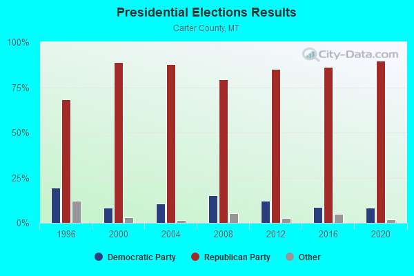
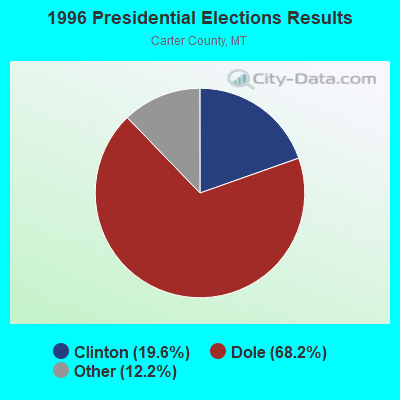
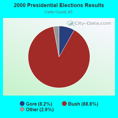
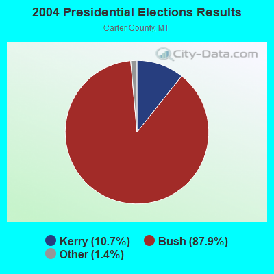
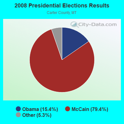
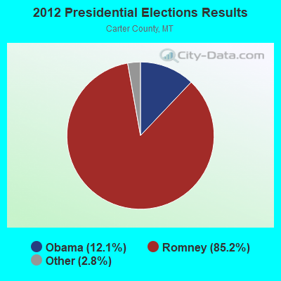
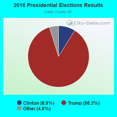
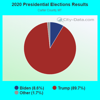
Graphs represent county-level data. Detailed 2008 Election Results
Religion statistics for Little Missouri, MT (based on Carter County data)
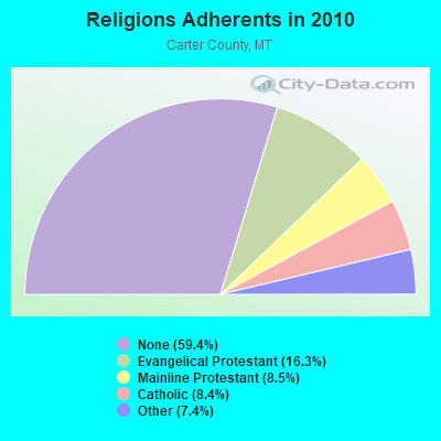
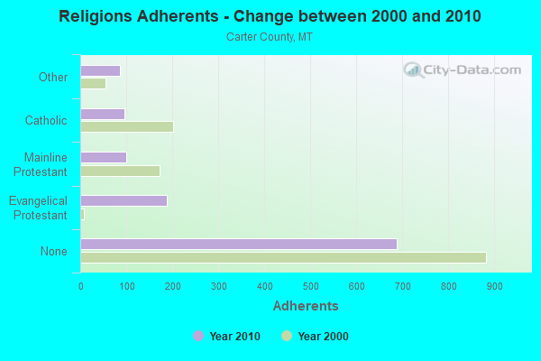
| Religion | Adherents | Congregations |
|---|---|---|
| Evangelical Protestant | 189 | 3 |
| Mainline Protestant | 99 | 1 |
| Catholic | 97 | 1 |
| Other | 86 | 1 |
| None | 689 | - |
Food Environment Statistics:
| Here: | 7.92 / 10,000 pop. |
| State: | 2.55 / 10,000 pop. |
| Carter County: | 23.77 / 10,000 pop. |
| Montana: | 4.69 / 10,000 pop. |
| Carter County: | 8.1% |
| Montana: | 7.2% |
| This county: | 24.0% |
| Montana: | 23.1% |
Strongest AM radio stations in Little Missouri:
- KBHB (810 AM; 25 kW; STURGIS, SD; Owner: MONTEREY LICENSES, LLC)
- KXMR (710 AM; 50 kW; BISMARCK, ND; Owner: RADIO BISMARCK MANDAN, LLC)
- KATL (770 AM; 10 kW; MILES CITY, MT; Owner: STAR PRINTING COMPANY)
- KTWO (1030 AM; 50 kW; CASPER, WY; Owner: CITICASTERS LICENSES, L.P.)
- KMTA (1050 AM; 10 kW; MILES CITY, MT; Owner: SENGER BROADCASTING CORPORATION)
- KFLN (960 AM; 5 kW; BAKER, MT; Owner: NEWELL BROADCASTING INC.)
- KKLS (920 AM; 10 kW; RAPID CITY, SD; Owner: MONTEREY LICENSES, LLC)
- KDSJ (980 AM; 5 kW; DEADWOOD, SD; Owner: GOLDRUSH BROADCASTING, INC.)
- KUYO (830 AM; daytime; 25 kW; EVANSVILLE, WY; Owner: WYOMING CHRISTIAN BROADCASTING COMPANY)
- KIML (1270 AM; 5 kW; GILLETTE, WY; Owner: GILLETTE BROADCASTING CO.)
- KLTT (670 AM; 50 kW; COMMERCE CITY, CO; Owner: KLZ RADIO, INC.)
- KIMB (1260 AM; 50 kW; KIMBALL, NE; Owner: G & L INVESTMENTS, LLC)
- KKZN (760 AM; 50 kW; THORNTON, CO; Owner: JACOR BROADCASTING OF COLORADO, INC.)

- 68.4%Bottled, tank, or LP gas
- 21.1%Wood
- 5.3%Utility gas
- 2.0%Electricity
- 2.0%Coal or coke
- 1.3%Fuel oil, kerosene, etc.

- 60.6%Bottled, tank, or LP gas
- 15.2%Wood
- 9.1%Utility gas
- 9.1%Electricity
- 6.1%Coal or coke
Little Missouri compared to Montana state average:
- Unemployed percentage significantly below state average.
- Black race population percentage significantly below state average.
- Hispanic race population percentage significantly below state average.
- Foreign-born population percentage significantly below state average.
- Renting percentage significantly below state average.
- Length of stay since moving in significantly above state average.
- Number of rooms per house significantly below state average.
- House age significantly below state average.
- Number of college students significantly below state average.
- Percentage of population with a bachelor's degree or higher below state average.
Little Missouri on our top lists:
- #39 on the list of "Top 100 cities with largest land areas"
- #46 on the list of "Top 101 counties with the lowest total withdrawal of fresh water for public supply"
- #71 on the list of "Top 101 counties with highest percentage of residents voting for Romney (Republican) in the 2012 Presidential Election"
- #95 on the list of "Top 101 counties with the largest number of people without health insurance coverage in 2000"