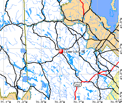
Limerick, Maine


Submit your own pictures of this town and show them to the world
- OSM Map
- General Map
- Google Map
- MSN Map
Population change since 2000: +29.1%
| Males: 1,452 | |
| Females: 1,440 |
| Median resident age: | 39.4 years |
| Maine median age: | 43.0 years |
Zip codes: 04048.
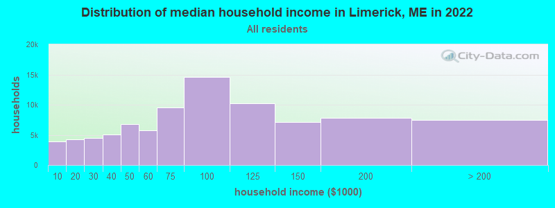
| Limerick: | $76,698 |
| ME: | $69,543 |
Estimated per capita income in 2022: $38,336 (it was $18,844 in 2000)
Limerick town income, earnings, and wages data
Estimated median house or condo value in 2022: $306,957 (it was $96,100 in 2000)
| Limerick: | $306,957 |
| ME: | $290,600 |
Mean prices in 2022: all housing units: $451,552; detached houses: $470,451; townhouses or other attached units: $577,335; in 2-unit structures: $383,179; in 3-to-4-unit structures: $310,696; in 5-or-more-unit structures: $252,113; mobile homes: $105,501
Detailed information about poverty and poor residents in Limerick, ME


- 2,79096.5%White alone
- 411.4%Two or more races
- 291.0%Hispanic
- 160.6%American Indian alone
- 100.3%Black alone
- 60.2%Asian alone
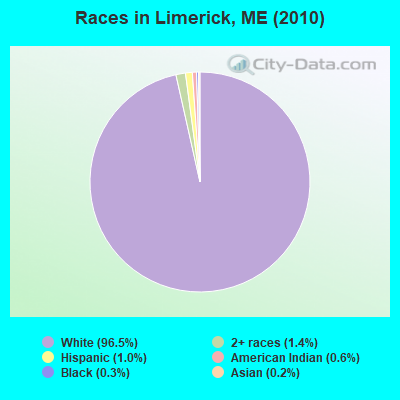
Races in Limerick detailed stats: ancestries, foreign born residents, place of birth
According to our research of Maine and other state lists, there were 6 registered sex offenders living in Limerick, Maine as of May 26, 2024.
The ratio of all residents to sex offenders in Limerick is 482 to 1.
The ratio of registered sex offenders to all residents in this city is near the state average.
 Recent articles from our blog. Our writers, many of them Ph.D. graduates or candidates, create easy-to-read articles on a wide variety of topics.

 | Good driving distance from Houlton in winter? (10 replies) |
| Why do people think I'm nuts for wanting to move to Aroostook county? (60 replies) |
| Maine Made Axes (3 replies) |
| Moving near Houlton (17 replies) |
| Information about Houlton and area?? (15 replies) |
| The best place to live in Maine. (394 replies) |
Latest news from Limerick, ME collected exclusively by city-data.com from local newspapers, TV, and radio stations
Ancestries: English (23.8%), Irish (23.0%), French (17.9%), German (8.0%), Italian (7.9%), French Canadian (7.6%).
Current Local Time: EST time zone
Incorporated on 03/06/1787
Elevation: 596 feet
Land area: 27.1 square miles.
Population density: 107 people per square mile (very low).
64 residents are foreign born (1.4% Europe, 1.1% North America).
| This town: | 2.9% |
| Maine: | 2.9% |
| Limerick town: | 1.3% ($1,224) |
| Maine: | 1.5% ($1,417) |
Nearest city with pop. 50,000+: Portland, ME  (25.2 miles , pop. 64,249).
Nearest city with pop. 200,000+: Boston, MA (95.5 miles , pop. 589,141).
Nearest city with pop. 1,000,000+: Bronx, NY (252.3 miles , pop. 1,332,650).
Nearest cities:
), ), ), ), )Latitude: 43.68 N, Longitude: 70.77 W
Area code: 207

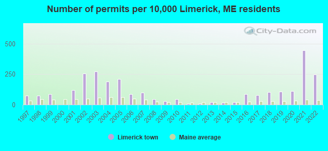
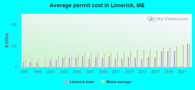
Single-family new house construction building permits:
- 2022: 55 buildings, average cost: $279,000
- 2021: 100 buildings, average cost: $15,000
- 2020: 25 buildings, average cost: $191,700
- 2019: 24 buildings, average cost: $191,700
- 2018: 23 buildings, average cost: $191,300
- 2017: 18 buildings, average cost: $120,400
- 2016: 19 buildings, average cost: $120,400
- 2015: 5 buildings, average cost: $101,000
- 2014: 4 buildings, average cost: $110,000
- 2013: 5 buildings, average cost: $119,600
- 2012: 2 buildings, average cost: $103,000
- 2011: 2 buildings, average cost: $95,000
- 2010: 10 buildings, average cost: $129,000
- 2009: 6 buildings, average cost: $110,800
- 2008: 10 buildings, average cost: $118,000
- 2007: 22 buildings, average cost: $103,600
- 2006: 19 buildings, average cost: $128,500
- 2005: 47 buildings, average cost: $111,700
- 2004: 43 buildings, average cost: $118,900
- 2003: 61 buildings, average cost: $114,800
- 2002: 57 buildings, average cost: $90,900
- 2001: 27 buildings, average cost: $80,400
- 1999: 19 buildings, average cost: $61,200
- 1998: 17 buildings, average cost: $61,200
- 1997: 17 buildings, average cost: $61,200
| Here: | 2.8% |
| Maine: | 3.4% |
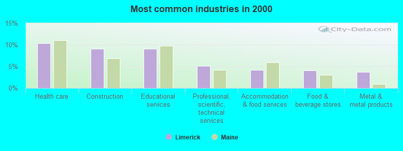
- Health care (10.4%)
- Construction (9.0%)
- Educational services (9.0%)
- Professional, scientific, technical services (5.2%)
- Accommodation & food services (4.1%)
- Food & beverage stores (4.0%)
- Metal & metal products (3.8%)

- Construction (15.5%)
- Health care (5.3%)
- Administrative & support & waste management services (5.0%)
- Computer & electronic products (4.8%)
- Public administration (4.8%)
- Metal & metal products (4.5%)
- Wood products (3.5%)

- Health care (16.8%)
- Educational services (16.4%)
- Professional, scientific, technical services (7.5%)
- Accommodation & food services (5.8%)
- Food & beverage stores (5.6%)
- Social assistance (5.2%)
- Finance & insurance (5.0%)

- Other production occupations, including supervisors (4.5%)
- Other sales and related occupations, including supervisors (4.5%)
- Material recording, scheduling, dispatching, and distributing workers (4.2%)
- Driver/sales workers and truck drivers (3.4%)
- Metal workers and plastic workers (3.3%)
- Secretaries and administrative assistants (3.2%)
- Engineers (3.0%)

- Other production occupations, including supervisors (6.4%)
- Driver/sales workers and truck drivers (5.8%)
- Engineers (5.5%)
- Laborers and material movers, hand (4.8%)
- Metal workers and plastic workers (4.8%)
- Electrical equipment mechanics and other installation, maintenance, and repair workers, including supervisors (4.6%)
- Vehicle and mobile equipment mechanics, installers, and repairers (4.1%)

- Secretaries and administrative assistants (7.3%)
- Preschool, kindergarten, elementary, and middle school teachers (5.8%)
- Other sales and related occupations, including supervisors (5.6%)
- Registered nurses (5.4%)
- Material recording, scheduling, dispatching, and distributing workers (4.8%)
- Cashiers (3.9%)
- Other teachers, instructors, education, training, and library occupations (3.3%)
Average climate in Limerick, Maine
Based on data reported by over 4,000 weather stations


(lower is better)
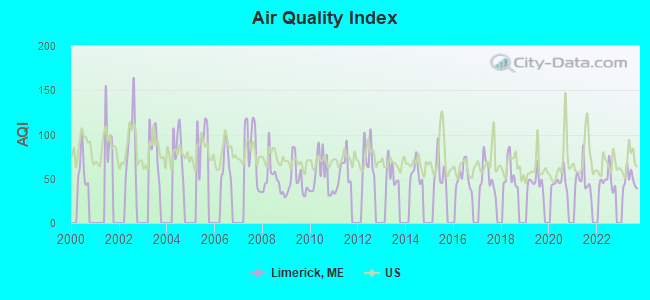
Air Quality Index (AQI) level in 2023 was 48.8. This is significantly better than average.
| City: | 48.8 |
| U.S.: | 72.6 |
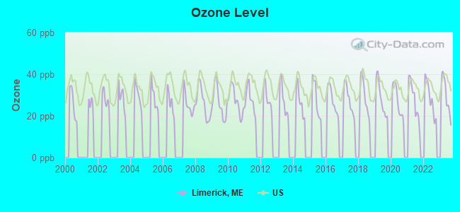
Ozone [ppb] level in 2023 was 29.7. This is about average. Closest monitor was 7.4 miles away from the city center.
| City: | 29.7 |
| U.S.: | 33.3 |
Tornado activity:
Limerick-area historical tornado activity is significantly above Maine state average. It is 71% smaller than the overall U.S. average.
On 10/10/1966, a category F2 (max. wind speeds 113-157 mph) tornado 17.5 miles away from the Limerick town center caused between $5000 and $50,000 in damages.
On 7/18/1963, a category F2 tornado 22.2 miles away from the town center caused between $5000 and $50,000 in damages.
Earthquake activity:
Limerick-area historical earthquake activity is significantly above Maine state average. It is 73% smaller than the overall U.S. average.On 10/16/2012 at 23:12:25, a magnitude 4.7 (4.7 ML, Depth: 10.0 mi, Class: Light, Intensity: IV - V) earthquake occurred 8.3 miles away from the city center
On 4/20/2002 at 10:50:47, a magnitude 5.3 (5.3 ML, Depth: 3.0 mi, Class: Moderate, Intensity: VI - VII) earthquake occurred 156.2 miles away from Limerick center
On 1/19/1982 at 00:14:42, a magnitude 4.7 (4.5 MB, 4.7 MD, 4.5 LG) earthquake occurred 43.4 miles away from the city center
On 4/20/2002 at 10:50:47, a magnitude 5.2 (5.2 MB, 4.2 MS, 5.2 MW, 5.0 MW) earthquake occurred 156.6 miles away from Limerick center
On 10/7/1983 at 10:18:46, a magnitude 5.3 (5.1 MB, 5.3 LG, 5.1 ML) earthquake occurred 179.1 miles away from the city center
On 8/21/1996 at 07:54:14, a magnitude 3.8 (3.8 LG, 3.6 LG, Depth: 6.2 mi, Class: Light, Intensity: II - III) earthquake occurred 45.1 miles away from Limerick center
Magnitude types: regional Lg-wave magnitude (LG), body-wave magnitude (MB), duration magnitude (MD), local magnitude (ML), surface-wave magnitude (MS), moment magnitude (MW)
Natural disasters:
The number of natural disasters in York County (31) is a lot greater than the US average (15).Major Disasters (Presidential) Declared: 23
Emergencies Declared: 8
Causes of natural disasters: Floods: 21, Storms: 16, Winter Storms: 6, Snows: 5, Winds: 3, Heavy Rains: 2, Hurricanes: 2, Blizzard: 1, Ice Storm: 1, Mudslide: 1, Snowfall: 1, Snowstorm: 1, Tornado: 1, Tropical Storm: 1 (Note: some incidents may be assigned to more than one category).

Colleges/universities with over 2000 students nearest to Limerick:
- Saint Joseph's College of Maine (about 18 miles; Standish, ME; Full-time enrollment: 2,010)
- University of New England (about 25 miles; Biddeford, ME; FT enrollment: 4,539)
- University of Southern Maine (about 25 miles; Portland, ME; FT enrollment: 6,647)
- Southern Maine Community College (about 28 miles; South Portland, ME; FT enrollment: 4,666)
- University of New Hampshire-Main Campus (about 39 miles; Durham, NH; FT enrollment: 15,243)
- Plymouth State University (about 47 miles; Plymouth, NH; FT enrollment: 4,838)
- NHTI-Concord's Community College (about 50 miles; Concord, NH; FT enrollment: 2,865)
Points of interest:
Notable location: Limerick Fire and Rescue Service (A). Display/hide its location on the map
Cemetery: Highland Cemetery (1). Display/hide its location on the map
Lakes and reservoirs: Pickerel Pond (A), Lake Arrowhead (B), The Flowage Reservoir (C), Sokokis Lake (D). Display/hide their locations on the map
Streams, rivers, and creeks: Spencer Brook (A), Leavitt Brook (B), Brown Brook (C). Display/hide their locations on the map
Birthplace of: Annie Carroll Moore - Children's writer, Alpheus Felch - Politician.
Drinking water stations with addresses in Limerick and their reported violations in the past:
LIMERICK WATER DISTRICT (Population served: 600, Groundwater):Past monitoring violations:LIMERICK MOBILE HOME PARK (Population served: 275, Groundwater):
- Water Quality Parameter M/R - Between JAN-2006 and JUN-2006, Contaminant: Lead and Copper Rule. Follow-up actions: St Violation/Reminder Notice (JUL-17-2006), St Compliance achieved (JUL-28-2006)
- Initial Tap Sampling for Pb and Cu - In JUL-11-2004, Contaminant: Lead and Copper Rule. Follow-up actions: St Public Notif requested (FEB-23-2005), St Violation/Reminder Notice (FEB-23-2005), St Public Notif received (APR-08-2005), St Compliance achieved (APR-22-2005)
Past health violations:Past monitoring violations:
- MCL, Average - Between JUL-2013 and SEP-2013, Contaminant: Arsenic. Follow-up actions: St Public Notif requested (SEP-20-2013), St Formal NOV issued (SEP-20-2013), St Public Notif received (OCT-22-2013)
- Follow-up Or Routine LCR Tap M/R - In JAN-01-2008, Contaminant: Lead and Copper Rule. Follow-up actions: St Public Notif requested (MAR-11-2008), St Formal NOV issued (MAR-11-2008), St Compliance achieved (MAR-09-2009), St Public Notif received (MAR-09-2009)
| This town: | 2.6 people |
| Maine: | 2.3 people |
| This town: | 73.0% |
| Whole state: | 62.9% |
| This town: | 10.1% |
| Whole state: | 9.4% |
Likely homosexual households (counted as self-reported same-sex unmarried-partner households)
- Lesbian couples: 0.4% of all households
- Gay men: 0.0% of all households
| This town: | 9.5% |
| Whole state: | 10.9% |
| This town: | 3.2% |
| Whole state: | 4.1% |
5 people in homes for the mentally retarded in 2000
Banks with branches in Limerick (2011 data):
- Sanford Institution for Savings: Limerick Branch at 31 Main Street, branch established on 1933/12/11. Info updated 2010/01/06: Bank assets: $433.1 mil, Deposits: $320.0 mil, headquarters in Sanford, ME, positive income, Commercial Lending Specialization, 8 total offices, Holding Company: Sis Bancorp, Mhc
For population 15 years and over in Limerick:
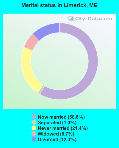
- Never married: 21.4%
- Now married: 58.6%
- Separated: 1.0%
- Widowed: 6.7%
- Divorced: 12.3%
For population 25 years and over in Limerick:
- High school or higher: 88.4%
- Bachelor's degree or higher: 19.9%
- Graduate or professional degree: 4.0%
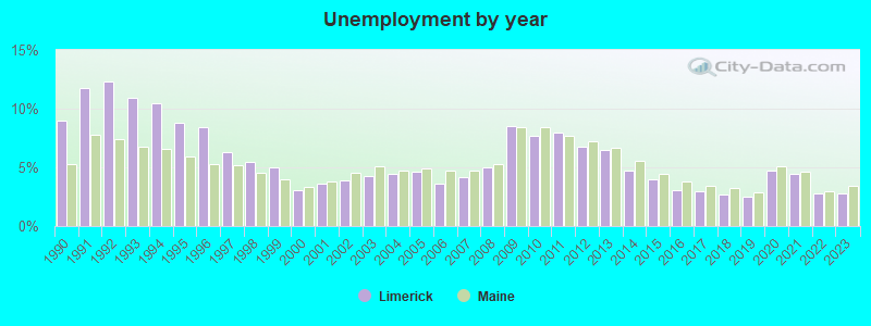
- Unemployed: 4.6%
- Mean travel time to work (commute): 38.5 minutes
| Here: | 9.6 |
| Maine average: | 11.2 |


Graphs represent county-level data. Detailed 2008 Election Results
Religion statistics for Limerick, ME (based on York County data)
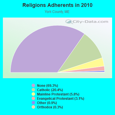

| Religion | Adherents | Congregations |
|---|---|---|
| Catholic | 40,283 | 16 |
| Mainline Protestant | 11,480 | 64 |
| Evangelical Protestant | 6,086 | 51 |
| Other | 1,847 | 18 |
| Orthodox | 625 | 3 |
| Black Protestant | 119 | 1 |
| None | 136,691 | - |
Food Environment Statistics:
| Here: | 2.24 / 10,000 pop. |
| State: | 2.80 / 10,000 pop. |
| York County: | 0.05 / 10,000 pop. |
| Maine: | 0.14 / 10,000 pop. |
| Here: | 2.09 / 10,000 pop. |
| Maine: | 2.20 / 10,000 pop. |
| York County: | 4.23 / 10,000 pop. |
| Maine: | 5.75 / 10,000 pop. |
| York County: | 12.53 / 10,000 pop. |
| Maine: | 11.02 / 10,000 pop. |
| York County: | 7.7% |
| State: | 8.2% |
| York County: | 24.0% |
| Maine: | 25.0% |
Businesses in Limerick, ME
- H&R Block: 1
Strongest AM radio stations in Limerick:
- WMTW (870 AM; 10 kW; GORHAM, ME; Owner: RADIO PARTNERS OF MAINE, L.P.)
- WGAN (560 AM; 5 kW; PORTLAND, ME; Owner: SAGA COMMUNICATIONS OF NEW ENGLAND, LLC)
- WGIN (930 AM; 10 kW; ROCHESTER, NH; Owner: CAPSTAR TX LIMITED PARTNERSHIP)
- WRKO (680 AM; 50 kW; BOSTON, MA; Owner: ENTERCOM BOSTON LICENSE, LLC)
- WZAN (970 AM; 5 kW; PORTLAND, ME; Owner: SAGA COMMUNICATIONS OF NEW ENGLAND, LLC)
- WJAE (1440 AM; 5 kW; WESTBROOK, ME; Owner: ALTANTIC COAST RADIO, LLC)
- WLOB (1310 AM; 5 kW; PORTLAND, ME; Owner: ATLANTIC COAST RADIO, LLC)
- WASR (1420 AM; 5 kW; WOLFEBORO, NH; Owner: RADIO WOLFEBORO, INC.)
- WEEI (850 AM; 50 kW; BOSTON, MA; Owner: ENTERCOM BOSTON LICENSE, LLC)
- WBZ (1030 AM; 50 kW; BOSTON, MA; Owner: INFINITY BROADCASTING OPERATIONS, INC.)
- WCRN (830 AM; 50 kW; WORCESTER, MA; Owner: CARTER BROADCASTING CORPORATION)
- WKOX (1200 AM; 50 kW; FRAMINGHAM, MA; Owner: CAPSTAR TX LIMITED PARTNERSHIP)
- WWZN (1510 AM; 50 kW; BOSTON, MA; Owner: ROSE CITY RADIO CORPORATION)
Strongest FM radio stations in Limerick:
- WMEA (90.1 FM; PORTLAND, ME; Owner: MAINE PUBLIC BROADCASTING CORPORATION)
- WSCY (106.9 FM; MOULTONBOROUGH, NH; Owner: NORTHEAST COMMUNICATIONS CORPORATION)
- WBLM (102.9 FM; PORTLAND, ME; Owner: CITADEL BROADCASTING COMPANY)
- WPKQ (103.7 FM; NORTH CONWAY, NH; Owner: CITADEL BROADCASTING COMPANY)
- WHOM (94.9 FM; MT. WASHINGTON, NH; Owner: CITADEL BROADCASTING COMPANY)
- WVFM (105.7 FM; CAMPTON, NH; Owner: DEVON BROADCASTING COMPANY, INC.)
- WPHX-FM (92.1 FM; SANFORD, ME; Owner: FNX BROADCASTING LLC)
- WSEW (88.5 FM; SANFORD, ME; Owner: WORD RADIO EDUCATIONAL FOUNDATION)
- WJBQ (97.9 FM; PORTLAND, ME; Owner: CITADEL BROADCASTING COMPANY)
- WLKZ (104.9 FM; WOLFEBORO, NH; Owner: TELE-MEDIA COMPANY OF NEW HAMPSHIRE, L.L.C.)
- WTHT (107.5 FM; LEWISTON, ME; Owner: RADIO PARTNERS OF MAINE, L.P.)
- WPOR (101.9 FM; PORTLAND, ME; Owner: SAGA COMMUNICATIONS OF NEW ENGLAND, LLC)
- WMEX (106.5 FM; FARMINGTON, NH; Owner: WIMMEX, LLC)
- WMTW-FM (106.7 FM; NORTH WINDHAM, ME; Owner: RADIO PARTNERS OF MAINE, L.P.)
- WCYY (94.3 FM; BIDDEFORD, ME; Owner: CITADEL BROADCASTING COMPANY)
- WRED (95.9 FM; SACO, ME; Owner: ATLANTIC COAST RADIO, LLC)
- WMSJ (89.3 FM; FREEPORT, ME; Owner: DOWNEAST CHRISTIAN COMMUNICATIONS)
- WMEK-FM (99.9 FM; AUBURN, ME; Owner: RADIO PARTNERS OF MAINE, L.P.)
- WUBB (95.3 FM; YORK CENTER, ME; Owner: CAPSTAR TX LIMITED PARTNERSHIP)
- WNHI (93.3 FM; BELMONT, NH; Owner: CONCORD BROADCASTING, L.L.C.)
TV broadcast stations around Limerick:
- WMTW-TV (Channel 8; POLAND SPRING, ME; Owner: WMTW BROADCAST GROUP, LLC)
- WCSH (Channel 6; PORTLAND, ME; Owner: PACIFIC AND SOUTHERN COMPANY, INC.)
- WMEA-TV (Channel 26; BIDDEFORD, ME; Owner: MAINE PUBLIC BROADCASTING CORP.)
- WGME-TV (Channel 13; PORTLAND, ME; Owner: WGME LICENSEE, LLC)
- WPXT (Channel 51; PORTLAND, ME; Owner: HMW, INC.)
- WPME (Channel 35; LEWISTON, ME; Owner: KB PRIME MEDIA LLC)
- W32CA (Channel 32; PORTLAND, ME; Owner: NATIONAL MINORITY T.V., INC.)
- National Bridge Inventory (NBI) Statistics
- 8Number of bridges
- 56ft / 16.5mTotal length
- 9,465Total average daily traffic
- 470Total average daily truck traffic
- 14,103Total future (year 2036) average daily traffic
FCC Registered Antenna Towers:
6- Mark L Gartley, 131 John & Marie Drive (Lat: 43.689417 Lon: -70.785111), Type: 47.2, Overall height: 45.7 m, Registrant: Holland & Knight LLP, Pconnolly@hklaw.Com, , Washi-ngton, Phone: (202) 862-5989
- Mark L Gartley, 131 John & Marie Drive (Lat: 43.689417 Lon: -70.785111), Type: 47.2, Overall height: 45.7 m, Registrant: Holland & Knight LLP, Pconnolly@hklaw.Com, , Washi-ngton, Phone: (202) 862-5989
- Michael J Umano, Off Elm Street (Lat: 43.665278 Lon: -70.829444), Type: 60.9, Overall height: 59.4 m, Registrant: Kevin.Delaney@induscom.Com, Phone: (781) 319-1011
- Cayla Gamble, 131 John & Marie Drive (Lat: 43.689417 Lon: -70.785111), Type: 47.2, Structure height: 23031 m, Overall height: 45.7 m, Registrant: Wilkinson Barker Knauer, LLP, Gwerner@wbklaw.Com, , Washi-ngton, Phone: (202) 383-3420
- Cayla Gamble, 131 John & Marie Drive (Lat: 43.689444 Lon: -70.785111), Type: 47.2, Structure height: 23031 m, Overall height: 45.7 m, Licensee ID: C, Registrant: United States Cellular Corporation, Regulatoryaffairs@uscellular.Com, , Chica-go, Phone: (800) 510-6091
- Cayla Gamble, 131 John & Marie Drive (Lat: 43.689444 Lon: -70.785111), Type: 47.2, Structure height: 23031 m, Overall height: 45.7 m, Registrant: Wilkinson Barker Knauer, LLP, Gwerner@wbklaw.Com, , Washi-ngton, Phone: (202) 383-3420
FCC Registered Broadcast Land Mobile Towers:
1- School St (Lat: 43.683417 Lon: -70.791167), Call Sign: KNFM421,
Assigned Frequencies: 33.8600 MHz, Grant Date: 04/28/2022, Expiration Date: 04/29/2032, Registrant: Limerick Fire Department, 24 School St., Limerick, ME 04048, Phone: (207) 793-3905, Email:
FCC Registered Amateur Radio Licenses:
24 (See the full list of FCC Registered Amateur Radio Licenses in Limerick)FAA Registered Aircraft:
7- Aircraft: ENGINEERING & RESEARCH 415-D (Category: Land, Seats: 2, Weight: Up to 12,499 Pounds, Speed: 90 mph), Engine: CONT MOTOR C85 SERIES (85 HP) (Reciprocating)
N-Number: 169WS, N169WS, N-169WS, Serial Number: 856, Year manufactured: 1946, Airworthiness Date: 09/09/1976, Certificate Issue Date: 05/12/1990
Registrant (Individual): Walter W Jr Lanoue, 34 Quarry Rd, Limerick, ME 04048 - Aircraft: SMITH MINIPLANE DSA-1 (Category: Land, Weight: Up to 12,499 Pounds, Speed: 86 mph), Engine: LYCOMING 0-290 SERIES (140 HP) (Reciprocating)
N-Number: 4756G, N4756G, N-4756G, Serial Number: G-1, Year manufactured: 1973, Airworthiness Date: 05/05/1980, Certificate Issue Date: 04/10/1998
Registrant (Individual): Randy M Oliver, 421 Elm St, Limerick, ME 04048 - Aircraft: CESSNA 172E (Category: Land, Seats: 4, Weight: Up to 12,499 Pounds, Speed: 105 mph), Engine: CONT MOTOR 0-300 SER (145 HP) (Reciprocating)
N-Number: 5723T, N5723T, N-5723T, Serial Number: 17251623, Year manufactured: 1964, Airworthiness Date: 05/21/1964, Certificate Issue Date: 06/04/2014
Registrant (Individual): David R Coleman, 15 Clarks Bridge Rd, Limerick, ME 04048 - Aircraft: CESSNA 172A (Category: Land, Seats: 4, Weight: Up to 12,499 Pounds, Speed: 105 mph), Engine: CONT MOTOR 0-300 SER (145 HP) (Reciprocating)
N-Number: 7602T, N7602T, N-7602T, Serial Number: 47202, Year manufactured: 1959, Airworthiness Date: 12/31/1959, Certificate Issue Date: 01/07/2015
Registrant (Individual): David R Coleman, 15 Clarks Bridge Rd, Limerick, ME 04048 - Aircraft: PIPER PA-12 (Category: Land, Seats: 3, Weight: Up to 12,499 Pounds, Speed: 82 mph), Engine: Reciprocating
N-Number: 7726H, N7726H, N-7726H, Serial Number: 12-622, Airworthiness Date: 10/02/1957, Certificate Issue Date: 08/08/2013
Registrant (Individual): Randy M Oliver, 421 Elm St, Limerick, ME 04048 - Aircraft: BELL ANDY SKYRAIDER II (Category: Land, Seats: 2, Weight: Up to 12,499 Pounds), Engine: AMA/EXPR UNKNOWN ENG (Reciprocating)
N-Number: 90AB, N90AB, N-90AB, Serial Number: SRII014, Airworthiness Date: 04/23/2002, Certificate Issue Date: 11/12/2020
Registrant (Individual): Jeffrey D Georgia, 50 Island Rd, Limerick, ME 04048 - Aircraft: ROYALL DAN M JR CHRISTEN EAGLE-II (Category: Land, Seats: 2, Weight: Up to 12,499 Pounds), Engine: LYCOMING AEIO-360 SER (180 HP) (Reciprocating)
N-Number: 916DR, N916DR, N-916DR, Serial Number: ROYALL-0001, Year manufactured: 1981, Airworthiness Date: 11/12/1981, Certificate Issue Date: 10/04/2005
Registrant (Individual): Randy M Oliver, 421 Elm St, Limerick, ME 04048
2004 - 2018 National Fire Incident Reporting System (NFIRS) incidents
- Fire incident types reported to NFIRS in Limerick, ME
- 14157.6%Structure Fires
- 6727.3%Outside Fires
- 218.6%Mobile Property/Vehicle Fires
- 166.5%Other
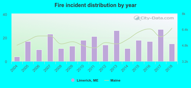 According to the data from the years 2004 - 2018 the average number of fires per year is 16. The highest number of fire incidents - 27 took place in 2017, and the least - 4 in 2004. The data has a rising trend.
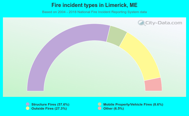 When looking into fire subcategories, the most incidents belonged to: Structure Fires (57.6%), and Outside Fires (27.3%).
- 84.3%Fuel oil, kerosene, etc.
- 10.5%Wood
- 3.2%Bottled, tank, or LP gas
- 1.4%Electricity
- 0.6%Utility gas
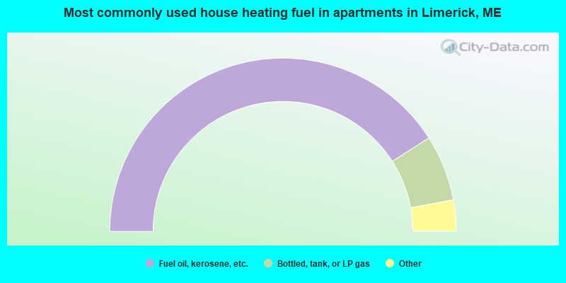
- 81.8%Fuel oil, kerosene, etc.
- 12.3%Bottled, tank, or LP gas
- 3.9%Wood
- 1.9%Electricity
Limerick compared to Maine state average:
- Unemployed percentage below state average.
- Black race population percentage significantly below state average.
- Renting percentage below state average.
- Length of stay since moving in significantly above state average.
- Number of rooms per house significantly below state average.
- House age significantly below state average.
- Number of college students below state average.

|
|
Total of 17 patent applications in 2008-2024.