Koolauloa, Hawaii
Submit your own pictures of this place and show them to the world
- OSM Map
- General Map
- Google Map
- MSN Map

| Males: 9,695 | |
| Females: 9,714 |
| Median resident age: | 29.2 years |
| Hawaii median age: | 36.2 years |
Zip code: 96762
| Koolauloa: | $86,713 |
| HI: | $92,458 |
Estimated per capita income in 2022: $34,206 (it was $17,255 in 2000)
Koolauloa CCD income, earnings, and wages data
Estimated median house or condo value in 2022: $869,723 (it was $273,100 in 2000)
| Koolauloa: | $869,723 |
| HI: | $820,100 |
Mean prices in 2022: all housing units: $999,130; detached houses: over $1,000,000; townhouses or other attached units: $982,127; in 2-unit structures: $920,464; in 3-to-4-unit structures: $717,340; in 5-or-more-unit structures: $577,655; mobile homes: over $1,000,000; occupied boats, rvs, vans, etc.: $319,807
Detailed information about poverty and poor residents in Koolauloa, HI


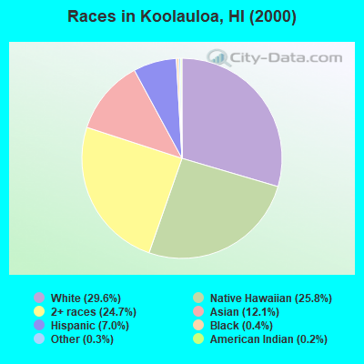
- 5,58929.6%White alone
- 4,87325.8%Native Hawaiian and Other
Pacific Islander alone - 4,67224.7%Two or more races
- 2,28312.1%Asian alone
- 1,3217.0%Hispanic
- 700.4%Black alone
- 540.3%Other race alone
- 370.2%American Indian alone
Races in Koolauloa detailed stats: ancestries, foreign born residents, place of birth
 Recent articles from our blog. Our writers, many of them Ph.D. graduates or candidates, create easy-to-read articles on a wide variety of topics.

Current Local Time: HST (no DST) time zone
Land area: 69.0 square miles.
Population density: 281 people per square mile (very low).

| Koolauloa CCD: | 0.3% ($782) |
| Hawaii: | 0.3% ($765) |
Nearest city with pop. 50,000+: Ewa, HI  (18.5 miles , pop. 272,328).
Nearest city with pop. 1,000,000+: Los Angeles, CA (2549.3 miles , pop. 3,694,820).
Nearest cities:
), ), )Latitude: 21.65 N, Longitude: 157.95 W


| Here: | 2.9% |
| Hawaii: | 2.9% |
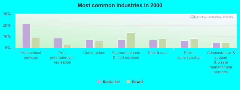
- Educational services (21.4%)
- Arts, entertainment, recreation (8.6%)
- Construction (7.3%)
- Accommodation & food services (7.1%)
- Health care (6.9%)
- Public administration (6.2%)
- Administrative & support & waste management services (4.8%)
- Educational services (15.5%)
- Construction (12.8%)
- Arts, entertainment, recreation (9.7%)
- Public administration (7.8%)
- Administrative & support & waste management services (6.9%)
- Accommodation & food services (6.5%)
- Agriculture, forestry, fishing & hunting (4.5%)

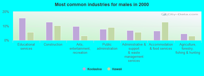
- Educational services (28.1%)
- Health care (11.7%)
- Accommodation & food services (7.8%)
- Arts, entertainment, recreation (7.2%)
- Public administration (4.4%)
- Social assistance (3.6%)
- Finance & insurance (3.6%)
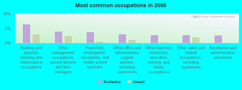
- Building and grounds cleaning and maintenance occupations (6.5%)
- Other management occupations, except farmers and farm managers (4.0%)
- Preschool, kindergarten, elementary, and middle school teachers (3.8%)
- Other office and administrative support workers, including supervisors (3.1%)
- Other teachers, instructors, education, training, and library occupations (2.8%)
- Other sales and related occupations, including supervisors (2.8%)
- Secretaries and administrative assistants (2.7%)
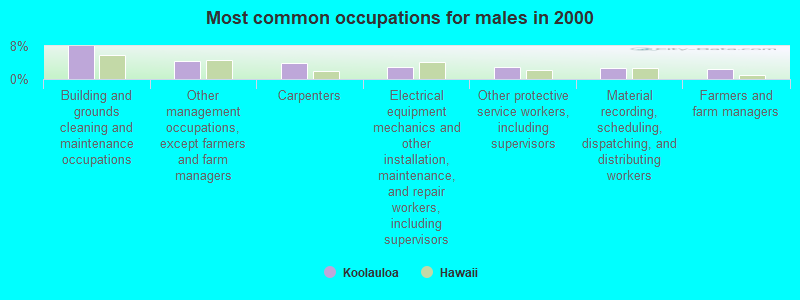
- Building and grounds cleaning and maintenance occupations (7.9%)
- Other management occupations, except farmers and farm managers (4.3%)
- Carpenters (3.8%)
- Electrical equipment mechanics and other installation, maintenance, and repair workers, including supervisors (2.8%)
- Other protective service workers, including supervisors (2.8%)
- Material recording, scheduling, dispatching, and distributing workers (2.6%)
- Farmers and farm managers (2.5%)
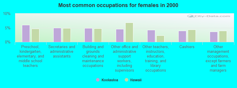
- Preschool, kindergarten, elementary, and middle school teachers (6.0%)
- Secretaries and administrative assistants (4.9%)
- Building and grounds cleaning and maintenance occupations (4.9%)
- Other office and administrative support workers, including supervisors (4.6%)
- Other teachers, instructors, education, training, and library occupations (4.2%)
- Cashiers (3.9%)
- Other management occupations, except farmers and farm managers (3.7%)
Average climate in Koolauloa, Hawaii
Based on data reported by over 4,000 weather stations


(lower is better)
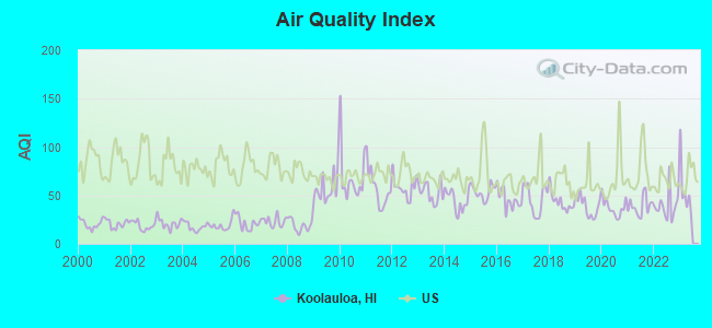
Air Quality Index (AQI) level in 2022 was 39.4. This is significantly better than average.
| City: | 39.4 |
| U.S.: | 72.6 |
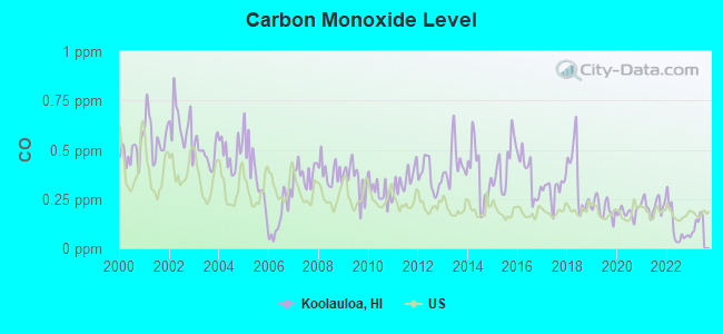
Carbon Monoxide (CO) [ppm] level in 2022 was 0.104. This is significantly better than average. Closest monitor was 24.6 miles away from the city center.
| City: | 0.104 |
| U.S.: | 0.251 |
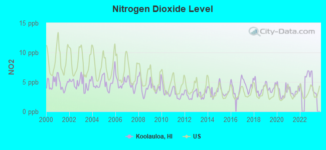
Nitrogen Dioxide (NO2) [ppb] level in 2022 was 5.88. This is about average. Closest monitor was 18.3 miles away from the city center.
| City: | 5.88 |
| U.S.: | 5.11 |
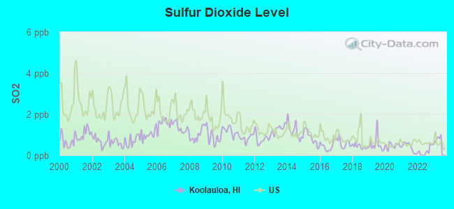
Sulfur Dioxide (SO2) [ppb] level in 2022 was 0.205. This is significantly better than average. Closest monitor was 18.2 miles away from the city center.
| City: | 0.205 |
| U.S.: | 1.515 |

Ozone [ppb] level in 2022 was 22.1. This is significantly better than average. Closest monitor was 24.6 miles away from the city center.
| City: | 22.1 |
| U.S.: | 33.3 |

Particulate Matter (PM10) [µg/m3] level in 2022 was 14.4. This is better than average. Closest monitor was 18.2 miles away from the city center.
| City: | 14.4 |
| U.S.: | 19.2 |

Particulate Matter (PM2.5) [µg/m3] level in 2022 was 4.00. This is significantly better than average. Closest monitor was 18.2 miles away from the city center.
| City: | 4.00 |
| U.S.: | 8.11 |
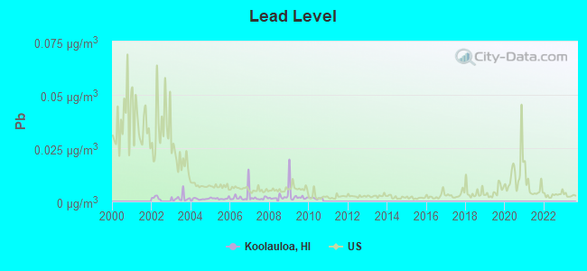
Lead (Pb) [µg/m3] level in 2010 was 0.00154. This is significantly better than average. Closest monitor was 15.9 miles away from the city center.
| City: | 0.00154 |
| U.S.: | 0.00931 |
Earthquake activity:
Koolauloa-area historical earthquake activity is significantly above Hawaii state average. It is 1035% greater than the overall U.S. average.On 11/29/1975 at 14:47:40, a magnitude 7.2 (6.0 MB, 7.1 MS, 7.2 UK, 7.2 MS, Class: Major, Intensity: VIII - XII) earthquake occurred 242.6 miles away from Koolauloa center, causing 2 deaths (2 shaking deaths)
On 8/21/1951 at 10:57:00, a magnitude 6.9 (6.9 UK, Class: Strong, Intensity: VII - IX) earthquake occurred 182.4 miles away from the city center
On 10/15/2006 at 17:07:49, a magnitude 6.7 (6.2 MB, 6.6 MS, 6.7 MW) earthquake occurred 177.4 miles away from the city center
On 10/15/2006 at 17:07:49, a magnitude 6.7 (6.7 MD, Depth: 23.7 mi) earthquake occurred 179.1 miles away from the city center
On 5/4/2018 at 22:32:54, a magnitude 6.9 (6.9 MW, Depth: 3.6 mi) earthquake occurred 250.2 miles away from Koolauloa center
On 11/16/1983 at 16:13:00, a magnitude 6.7 (6.4 MB, 6.7 MS, 6.7 MW) earthquake occurred 226.4 miles away from the city center, causing $6,000,000 total damage
Magnitude types: body-wave magnitude (MB), duration magnitude (MD), surface-wave magnitude (MS), moment magnitude (MW)
Natural disasters:
The number of natural disasters in Honolulu County (16) is near the US average (15).Major Disasters (Presidential) Declared: 10
Emergencies Declared: 1
Causes of natural disasters: Floods: 7, Storms: 7, Fires: 3, Mudslides: 3, Landslides: 2, Earthquake: 1, Flash Flood: 1, Heavy Rain: 1, Hurricane: 1, Tsunami Wave: 1, Typhoon: 1, Other: 1 (Note: some incidents may be assigned to more than one category).
Hospitals and medical centers near Koolauloa:
- WAHIAWA GENERAL HOSPITAL HHA (Home Health Center, about 12 miles away; WAHIAWA, HI)
- FMC WAHIAWA DIALYSIS CENTER (Dialysis Facility, about 12 miles away; WAHIAWA, HI)
- WAHIAWA GENERAL HOSPITAL (Nursing Home, about 12 miles away; WAHIAWA, HI)
- WAHIAWA GEN HOSP ICF (Nursing Home, about 12 miles away; WHIAWA, HI)
- ALOHA HEALTH CARE CENTER (Nursing Home, about 16 miles away; KANEOHE, HI)
- ALOHA NURSING AND REHAB CENTRE (Nursing Home, about 16 miles away; KANEOHE, HI)
Colleges/universities with over 2000 students nearest to Koolauloa:
- Brigham Young University-Hawaii (about 2 miles; Laie, HI; Full-time enrollment: 3,527)
- Leeward Community College (about 19 miles; Pearl City, HI; FT enrollment: 4,589)
- Honolulu Community College (about 24 miles; Honolulu, HI; FT enrollment: 2,538)
- Hawaii Pacific University (about 25 miles; Honolulu, HI; FT enrollment: 5,506)
- University of Hawaii at Manoa (about 27 miles; Honolulu, HI; FT enrollment: 16,461)
- Chaminade University of Honolulu (about 27 miles; Honolulu, HI; FT enrollment: 2,610)
- Kapiolani Community College (about 29 miles; Honolulu, HI; FT enrollment: 5,069)
Points of interest:
Notable locations in Koolauloa: Makaiwa (A), Pu‘uomahuka Heiau (B), Washington Statue (C), Kahuku Golf Course (D), Kulima Golf Course (E), Pu‘u O Mahuka Heiau (F), Kahuku Wastewater Treatment Plant (G), Kuilima Wastewater Treatment Plant (H), La'ie Water Reclamation Facility (I), Camp Pūpūkea (J), Camp Paumalū (K), Kapa‘ele‘ele Boat Ramp (L), Aloha Center (M), Honolulu Fire Department Station 13 Kahuku (N), Honolulu Fire Department Station 15 Hauula (O), Honolulu Fire Department Station 11 Sunset Beach (P), Emergency Medical Services Unit Kahuku (Q), Honolulu Fire Department Station 21 Kaaawa (R), Kahuku Public and School Library (S), Emergency Medical Services Unit Rapid Response District 2 (T). Display/hide their locations on the map
Shopping Centers: Lā‘ie Shopping Center (1), Hau‘ula Kai Shopping Center (2). Display/hide their locations on the map
Churches in Koolauloa include: Holy Cross Episcopal Mission (A), Kahuku United Methodist Church (B), Sunset Beach Church of Christ (C), Hauula Congregational Church (D), Lā‘ie Temple (E), Saints Peter and Paul Mission (F), Saint Roch Church (G), Hauula Seventh-Day Adventist Church (H), North Windward Baptist Chapel (I). Display/hide their locations on the map
Cemeteries: Kahuku Catholic Cemetery (1), Laie Community Cemetery (2), Japanese Graveyard (3). Display/hide their locations on the map
Lakes and swamps: Kaluakauwa Pond (A), Wai‘āpuka (B), Punamanō (C), Ki‘i (D), Punaho‘olapa (E), Kalou Marsh (F). Display/hide their locations on the map
Streams, rivers, and creeks: Maipuna Stream (A), Paumalū Stream (B), Maakua Stream (C), Kawela Stream (D), Kokololio Stream (E), Punalu‘u Stream (F), Koloa Stream (G), Kawa Stream (H), Waimea River (I). Display/hide their locations on the map
Parks in Koolauloa include: Punalu‘u Beach Park (1), Hau‘ula Community Park (2), Pūpūkea Beach Park (3), Lā‘ie Beach Park (4), Kokololio Beach Park (5), Sunset Beach Support Park (6), Kahawai Beach Support Park (7), Swanzy Beach Park (8), Kawela Bay Beach Park (9). Display/hide their locations on the map
Beaches: Kanenelu Beach (A), Hanaka‘ilio Beach (B), Three Tables (C), Pounders Beach (D), Sunset Beach (E), Hau‘ula Beach Park (F), Pahipahi‘ālua Beach (G), Kaluanui Beach (H), Mahakea Beach (I). Display/hide their locations on the map
| This place: | 3.5 people |
| Hawaii: | 2.9 people |
| This place: | 72.8% |
| Whole state: | 68.9% |
| This place: | 7.1% |
| Whole state: | 7.3% |
Likely homosexual households (counted as self-reported same-sex unmarried-partner households)
- Lesbian couples: 0.4% of all households
- Gay men: 0.3% of all households
| This place: | 16.8% |
| Whole state: | 10.7% |
| This place: | 7.4% |
| Whole state: | 5.0% |
People in group quarters in Koolauloa in 2010:
- 1,867 people in college/university student housing
- 304 people in other noninstitutional facilities
- 80 people in nursing facilities/skilled-nursing facilities
People in group quarters in Koolauloa in 2000:
- 534 people in college dormitories (includes college quarters off campus)
- 71 people in other noninstitutional group quarters
- 49 people in agriculture workers' dormitories on farms
- 46 people in nursing homes
- 24 people in homes or halfway houses for drug/alcohol abuse
- 15 people in other group homes
- 12 people in homes for the mentally retarded
- 10 people in wards in general hospitals for patients who have no usual home elsewhere
- 3 people in hospitals/wards and hospices for chronically ill
- 3 people in hospices or homes for chronically ill
For population 15 years and over in Koolauloa:
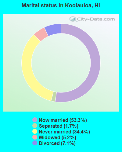
- Never married: 34.4%
- Now married: 53.3%
- Separated: 1.7%
- Widowed: 5.2%
- Divorced: 7.1%
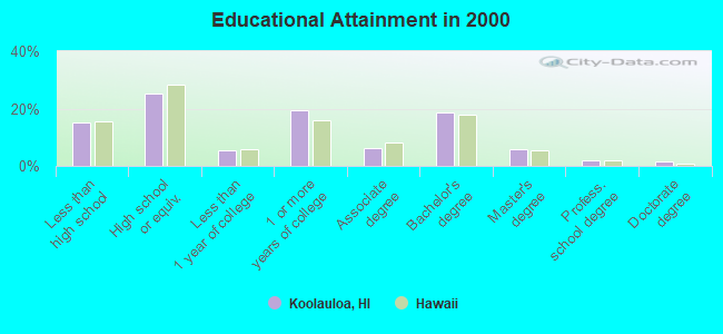
For population 25 years and over in Koolauloa:
- High school or higher: 85.0%
- Bachelor's degree or higher: 28.2%
- Graduate or professional degree: 9.6%
- Unemployed: 7.8%
- Mean travel time to work (commute): 31.5 minutes
| Here: | 12.1 |
| Hawaii average: | 12.8 |
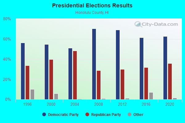
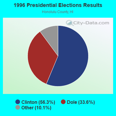
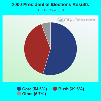
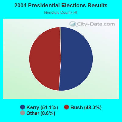
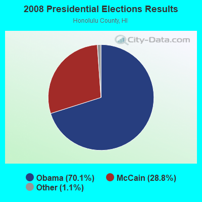
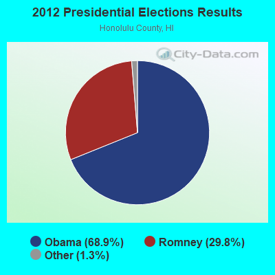
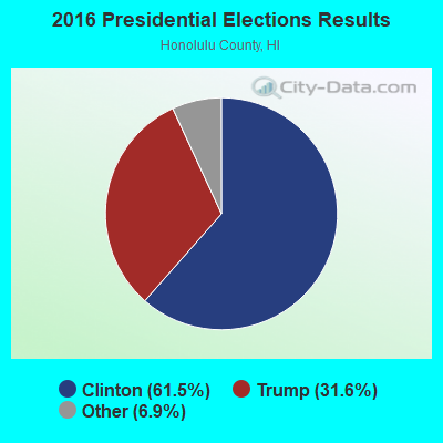
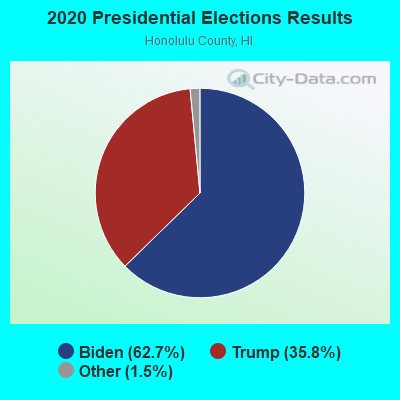
Graphs represent county-level data. Detailed 2008 Election Results
Religion statistics for Koolauloa, HI (based on Honolulu County data)
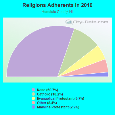
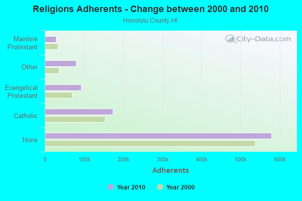
| Religion | Adherents | Congregations |
|---|---|---|
| Catholic | 173,716 | 39 |
| Evangelical Protestant | 92,310 | 382 |
| Other | 80,221 | 204 |
| Mainline Protestant | 28,013 | 115 |
| Orthodox | 300 | 4 |
| None | 578,647 | - |
Food Environment Statistics:
| Here: | 2.17 / 10,000 pop. |
| State: | 2.30 / 10,000 pop. |
| Honolulu County: | 0.10 / 10,000 pop. |
| Hawaii: | 0.09 / 10,000 pop. |
| This county: | 1.40 / 10,000 pop. |
| Hawaii: | 1.57 / 10,000 pop. |
| This county: | 1.57 / 10,000 pop. |
| Hawaii: | 1.72 / 10,000 pop. |
| Honolulu County: | 8.15 / 10,000 pop. |
| Hawaii: | 9.00 / 10,000 pop. |
| Honolulu County: | 8.3% |
| Hawaii: | 8.1% |
| Here: | 20.5% |
| Hawaii: | 20.8% |
| Honolulu County: | 8.9% |
| Hawaii: | 9.2% |
4.80% of this county's 2021 resident taxpayers lived in other counties in 2020 ($72,704 average adjusted gross income)
| Here: | 4.80% |
| Hawaii average: | 4.91% |
0.27% of residents moved from foreign countries ($4,064 average AGI)
Honolulu County: 0.27% Hawaii average: 0.19%
Top counties from which taxpayers relocated into this county between 2020 and 2021:
| from San Diego County, CA | |
| from Los Angeles County, CA | |
| from Hawaii County, HI |
5.90% of this county's 2020 resident taxpayers moved to other counties in 2021 ($71,643 average adjusted gross income)
| Here: | 5.90% |
| Hawaii average: | 5.53% |
0.21% of residents moved to foreign countries ($2,928 average AGI)
Honolulu County: 0.21% Hawaii average: 0.15%
Top counties to which taxpayers relocated from this county between 2020 and 2021:
| to Clark County, NV | |
| to San Diego County, CA | |
| to Hawaii County, HI |
Strongest AM radio stations in Koolauloa:
- KHNR (650 AM; 10 kW; HONOLULU, HI; Owner: SALEM MEDIA OF HAWAII, INC.)
- KHCM (940 AM; 10 kW; WAIPAHU, HI; Owner: SALEM MEDIA OF HAWAII, INC.)
- KSSK (590 AM; 8 kW; HONOLULU, HI; Owner: CAPSTAR TX LIMITED PARTNERSHIP)
- KHVH (830 AM; 10 kW; HONOLULU, HI; Owner: CAPSTAR TX LIMITED PARTNERSHIP)
- KORL (690 AM; 10 kW; HONOLULU, HI; Owner: NEW WAVE BROADCASTING, L.P.)
- KJPN (1370 AM; 6 kW; PEARL CITY, HI; Owner: DIAMOND BROADCASTING CORPORATION)
- KGU (760 AM; 10 kW; HONOLULU, HI; Owner: SALEM MEDIA OF HAWAII, INC.)
- KLHT (1040 AM; 10 kW; HONOLULU, HI; Owner: CALVARY CHAPEL OF HONOLULU, INC.)
- KAIM (870 AM; 50 kW; HONOLULU, HI; Owner: SALEM MEDIA OF HAWAII, INC.)
- KUMU (1500 AM; 10 kW; HONOLULU, HI; Owner: MAVERICK MEDIA OF OAHU LICENSE LLC)
- KHBZ (990 AM; 5 kW; HONOLULU, HI; Owner: CAPSTAR TX LIMITED PARTNERSHIP)
- KNDI (1270 AM; 5 kW; HONOLULU, HI; Owner: BROADCAST HOUSE OF THE PACIFIC INC.)
- KWAI (1080 AM; 5 kW; HONOLULU, HI; Owner: RADIO HAWAII, INC.)
Strongest FM radio stations in Koolauloa:
- KIPO (89.3 FM; HONOLULU, HI; Owner: HAWAII PUBLIC RADIO)
- KAIM-FM (95.5 FM; HONOLULU, HI; Owner: SALEM MEDIA OF HAWAII, INC.)
- KAHA (105.9 FM; HONOLULU, HI; Owner: KASA MOKU KA PAWA BROADCASTING, INC.)
- KCCN-FM (100.3 FM; HONOLULU, HI; Owner: CXR HOLDINGS, INC.)
- KGMZ-FM (107.9 FM; AIEA, HI; Owner: HONOLULU BROADCASTING, INC.)
- KINE-FM (105.1 FM; HONOLULU, HI; Owner: CXR HOLDINGS, INC.)
- KUCD (101.9 FM; PEARL CITY, HI; Owner: CAPSTAR TX LIMITED PARTNERSHIP)
- KSSK-FM (92.3 FM; WAIPAHU, HI; Owner: CAPSTAR TX LIMITED PARTNERSHIP)
- KDDB (102.7 FM; WAIPAHU, HI; Owner: NEW WAVE BROADCASTING, L.P.)
- KPOI-FM (97.5 FM; HONOLULU, HI; Owner: NEW WAVE BROADCASTING, L.P.)
- KQMQ-FM (93.1 FM; HONOLULU, HI; Owner: NEW WAVE BROADCASTING, L.P.)
- KXME (104.3 FM; KANEOHE, HI; Owner: CXR HOLDINGS, INC.)
- KRTR-FM (96.3 FM; KAILUA, HI; Owner: CXR HOLDINGS, INC.)
- KHUI (99.5 FM; HONOLULU, HI; Owner: NEW WAVE BROADCASTING, L.P.)
- K215EH (90.9 FM; KAILUA, HI; Owner: CALVARY CHAPEL OF TWIN FALLS, INC.)
TV broadcast stations around Koolauloa:
- KHON-TV (Channel 2; HONOLULU, HI; Owner: EMMIS TELEVISION LICENSE CORPORATION)
- KWHE (Channel 14; HONOLULU, HI; Owner: LESEA BROADCASTING CORPORATION)
- KGMB (Channel 9; HONOLULU, HI; Owner: EMMIS TELEVISION LICENSE CORPORATION)
- KITV (Channel 4; HONOLULU, HI; Owner: KITV HEARST-ARGYLE TV, INC. (CA CORP.))
- KHET (Channel 11; HONOLULU, HI; Owner: HAWAII PUBLIC TELEVISION FOUNDATION)
- KBFD (Channel 32; HONOLULU, HI; Owner: THE ALLEN BROADCASTING CORP.)
- KHNL (Channel 13; HONOLULU, HI; Owner: RAYCOM NATIONAL, INC.)
- KIKU (Channel 20; HONOLULU, HI; Owner: KHLS, INC.)
FCC Registered Antenna Towers:
9 (See the full list of FCC Registered Antenna Towers in Koolauloa)FCC Registered Broadcast Land Mobile Towers:
1- Lat: 21.696139 Lon: -157.997611, Call Sign: WQYD685,
Assigned Frequencies: 452.062 MHz, 457.062 MHz, 451.562 MHz, 456.562 MHz, 456.462 MHz, Grant Date: 08/25/2016, Expiration Date: 08/25/2026, Certifier: Everett La Rue, Registrant: Cara Enterprises, Inc., Las Vegas, NV 89140, Phone: (702) 838-9728, Fax: (702) 363-4607, Email:
FCC Registered Microwave Towers:
1- MT KAWELA, Mt. Kawela, 2.5 Mi. S. Of Kawela Bay (Lat: 21.664583 Lon: -158.000361), Type: Ltower, Structure height: 61.3 m, Overall height: 64.9 m, Call Sign: WLN238,
Assigned Frequencies: 6850.00 MHz, Grant Date: 03/28/2011, Expiration Date: 02/01/2021, Cancellation Date: 08/27/2014, Certifier: Carol L Tacker, Registrant: At&t Mobility LLC, 2200 N. Greenville Ave, 1w, Richardson, TX 75082, Phone: (972) 234-7003, Fax: (972) 301-6893, Email:
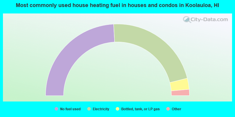
- 48.3%No fuel used
- 43.9%Electricity
- 5.0%Bottled, tank, or LP gas
- 1.8%Solar energy
- 0.6%Utility gas
- 0.3%Wood
- 0.1%Other fuel
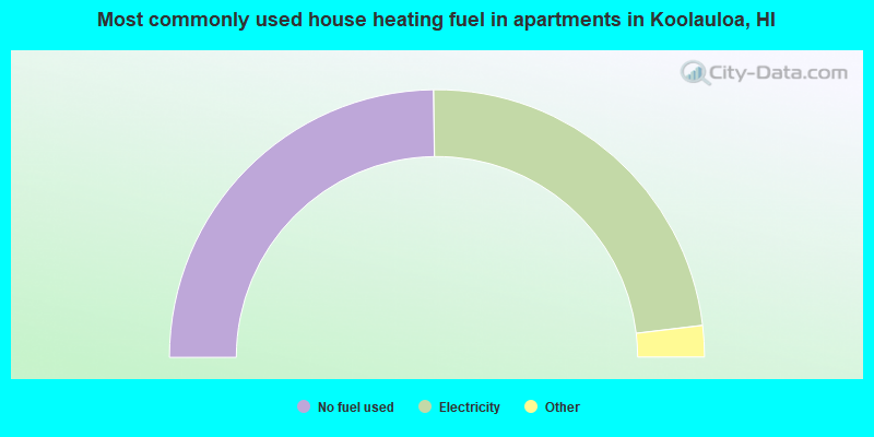
- 49.6%No fuel used
- 46.6%Electricity
- 1.7%Bottled, tank, or LP gas
- 1.1%Solar energy
- 0.7%Utility gas
- 0.2%Other fuel
Koolauloa compared to Hawaii state average:
- Unemployed percentage below state average.
- Black race population percentage significantly below state average.
- Median age significantly below state average.
- Foreign-born population percentage significantly below state average.
- Length of stay since moving in significantly above state average.
- Number of rooms per house significantly below state average.
- House age significantly below state average.
Koolauloa on our top lists:
- #4 on the list of "Top 101 cities with largest percentage of females in occupations: transportation, tourism, and lodging attendants (population 5,000+)"
- #6 on the list of "Top 101 cities with largest percentage of males in occupations: transportation, tourism, and lodging attendants (population 5,000+)"
- #13 on the list of "Top 101 cities with largest percentage of males in occupations: entertainers and performers, sports, and related workers (population 5,000+)"
- #18 on the list of "Top 101 cities with largest percentage of females in occupations: special education teachers (population 5,000+)"
- #30 on the list of "Top 101 cities with largest percentage of males in occupations: other teachers and instructors, education, training, and library occupations (population 5,000+)"
- #36 on the list of "Top 101 cities with largest percentage of males in occupations: secretaries and administrative assistants (population 5,000+)"
- #38 on the list of "Top 101 cities with largest percentage of males in industries: air transportation (population 5,000+)"
- #61 on the list of "Top 101 cities with largest percentage of females in industries: air transportation (population 5,000+)"
- #65 on the list of "Top 101 larger cities with the lowest real estate taxes percentage (population 50,000+)"
- #87 on the list of "Top 101 cities with largest percentage of males in industries: other transportation, and support activities, and couriers (population 5,000+)"
- #46 (96762) on the list of "Top 101 zip codes with the largest charity contributions deductions as a percentage of AGI in 2012 (pop 1,000+)"
- #50 (96762) on the list of "Top 101 zip codes with the smallest percentage of taxpayers using paid preparers for 2012 taxes (pop 1,000+)"
- #7 on the list of "Top 101 counties with the lowest average weight of females"
- #15 on the list of "Top 101 counties with the highest ground withdrawal of fresh water for public supply"
- #21 on the list of "Top 101 counties with the most Other congregations"
- #25 on the list of "Top 101 counties with the most Other adherents"
- #25 on the list of "Top 101 counties with the highest carbon monoxide air pollution readings in 2012 (ppm)"