Kenton-Mason Hall, Tennessee
Submit your own pictures of this place and show them to the world
- OSM Map
- Google Map
- MSN Map
| Males: 633 | |
| Females: 708 |
| Median resident age: | 39.7 years |
| Tennessee median age: | 35.9 years |
Zip code: 38233
| Kenton-Mason Hall: | $48,447 |
| TN: | $65,254 |
Estimated per capita income in 2022: $26,263 (it was $15,598 in 2000)
Kenton-Mason Hall CCD income, earnings, and wages data
Estimated median house or condo value in 2022: $128,502 (it was $56,700 in 2000)
| Kenton-Mason Hall: | $128,502 |
| TN: | $284,800 |
Kenton-Mason Hall, TN residents, houses, and apartments details
Detailed information about poverty and poor residents in Kenton-Mason Hall, TN


- 1,29894.1%White alone
- 443.2%Black alone
- 241.7%Hispanic
- 120.9%Two or more races
- 10.07%American Indian alone
- 10.07%Asian alone

Races in Kenton-Mason Hall detailed stats: ancestries, foreign born residents, place of birth
 Recent articles from our blog. Our writers, many of them Ph.D. graduates or candidates, create easy-to-read articles on a wide variety of topics.
Current Local Time: CST time zone
Land area: 59.1 square miles.
Population density: 23 people per square mile (very low).
| Kenton-Mason Hall CCD: | 0.6% ($355) |
| Tennessee: | 0.8% ($715) |
Nearest city with pop. 50,000+: Jackson, TN  (43.7 miles , pop. 59,643).
Nearest city with pop. 200,000+: Memphis, TN (91.8 miles , pop. 650,100).
Nearest city with pop. 1,000,000+: Chicago, IL (395.3 miles , pop. 2,896,016).
Nearest cities:
), ), ), ), ), )Latitude: 36.23 N, Longitude: 89.08 W
Area code commonly used in this area: 731

| Here: | 3.4% |
| Tennessee: | 3.0% |

- Plastics & rubber products (17.0%)
- Health care (13.4%)
- Truck transportation (5.9%)
- Food (5.7%)
- Educational services (5.4%)
- Machinery (5.4%)
- Public administration (4.4%)

- Plastics & rubber products (21.0%)
- Truck transportation (10.4%)
- Machinery (9.5%)
- Educational services (8.1%)
- Construction (7.2%)
- Agriculture, forestry, fishing & hunting (6.6%)
- Public administration (4.9%)

- Health care (31.2%)
- Plastics & rubber products (11.8%)
- Food (8.0%)
- Used merchandise, gift, novelty, souvenir, other miscellaneous stores (4.6%)
- Food & beverage stores (4.2%)
- Department & other general merchandise stores (3.8%)
- Public administration (3.8%)

- Other production occupations, including supervisors (10.3%)
- Metal workers and plastic workers (6.7%)
- Driver/sales workers and truck drivers (5.9%)
- Electricians (4.8%)
- Cashiers (3.6%)
- Laborers and material movers, hand (3.6%)
- Other material moving workers, except laborers (3.6%)

- Other production occupations, including supervisors (11.5%)
- Driver/sales workers and truck drivers (10.4%)
- Electricians (8.4%)
- Metal workers and plastic workers (6.9%)
- Electrical equipment mechanics and other installation, maintenance, and repair workers, including supervisors (6.1%)
- Other material moving workers, except laborers (4.6%)
- Other office and administrative support workers, including supervisors (4.0%)

- Other production occupations, including supervisors (8.7%)
- Cashiers (8.4%)
- Health technologists and technicians (7.2%)
- Metal workers and plastic workers (6.5%)
- Material recording, scheduling, dispatching, and distributing workers (4.6%)
- Retail sales workers, except cashiers (4.6%)
- Information and record clerks, except customer service representatives (4.6%)
Average climate in Kenton-Mason Hall, Tennessee
Based on data reported by over 4,000 weather stations


(lower is better)

Air Quality Index (AQI) level in 2022 was 61.7. This is about average.
| City: | 61.7 |
| U.S.: | 72.6 |

Nitrogen Dioxide (NO2) [ppb] level in 2003 was 3.30. This is significantly better than average. Closest monitor was 15.6 miles away from the city center.
| City: | 3.30 |
| U.S.: | 5.11 |

Sulfur Dioxide (SO2) [ppb] level in 2003 was 1.35. This is about average. Closest monitor was 15.6 miles away from the city center.
| City: | 1.35 |
| U.S.: | 1.51 |

Ozone [ppb] level in 2003 was 34.2. This is about average. Closest monitor was 13.3 miles away from the city center.
| City: | 34.2 |
| U.S.: | 33.3 |

Particulate Matter (PM2.5) [µg/m3] level in 2022 was 7.65. This is about average. Closest monitor was 20.8 miles away from the city center.
| City: | 7.65 |
| U.S.: | 8.11 |
Tornado activity:
Kenton-Mason Hall-area historical tornado activity is slightly above Tennessee state average. It is 97% greater than the overall U.S. average.
On 3/1/1997, a category F4 (max. wind speeds 207-260 mph) tornado 9.4 miles away from the Kenton-Mason Hall place center injured 15 people and caused $2 million in damages.
On 3/1/1997, a category F4 tornado 10.0 miles away from the place center caused $100,000 in damages.
Earthquake activity:
Kenton-Mason Hall-area historical earthquake activity is significantly above Tennessee state average. It is 369% greater than the overall U.S. average.On 5/4/1991 at 01:18:54, a magnitude 5.0 (4.4 MB, 4.6 LG, 5.0 LG, Depth: 3.1 mi, Class: Moderate, Intensity: VI - VII) earthquake occurred 47.4 miles away from the city center
On 9/26/1990 at 13:18:51, a magnitude 5.0 (4.7 MB, 4.8 LG, 5.0 LG, Depth: 7.7 mi) earthquake occurred 69.6 miles away from Kenton-Mason Hall center
On 3/25/1976 at 00:41:20, a magnitude 5.0 (4.9 MB, 5.0 LG) earthquake occurred 81.0 miles away from the city center
On 4/18/2008 at 09:36:59, a magnitude 5.4 (5.1 MB, 4.8 MS, 5.4 MW, 5.2 MW) earthquake occurred 167.2 miles away from the city center
On 4/27/1989 at 16:47:49, a magnitude 4.7 (4.6 MB, 4.7 LG, 4.3 LG, Class: Light, Intensity: IV - V) earthquake occurred 41.4 miles away from Kenton-Mason Hall center
On 4/18/2008 at 09:36:59, a magnitude 5.2 (5.2 MW, Depth: 8.9 mi) earthquake occurred 167.1 miles away from Kenton-Mason Hall center
Magnitude types: regional Lg-wave magnitude (LG), body-wave magnitude (MB), surface-wave magnitude (MS), moment magnitude (MW)
Natural disasters:
The number of natural disasters in Obion County (14) is near the US average (15).Major Disasters (Presidential) Declared: 11
Emergencies Declared: 1
Causes of natural disasters: Floods: 12, Storms: 10, Tornadoes: 4, Winds: 3, Winter Storms: 2, Hurricane: 1, Landslide: 1, Mudslide: 1, Other: 1 (Note: some incidents may be assigned to more than one category).
Hospitals and medical centers near Kenton-Mason Hall:
- DYER NURSING AND REHABILITATION CENTER (Nursing Home, about 11 miles away; DYER, TN)
- EXTENDICARE HOME HEALTH OF WESTERN TN (Home Health Center, about 13 miles away; UNION CITY, TN)
- UNION CITY MANOR (Nursing Home, about 13 miles away; UNION CITY, TN)
- UNION CITY MANOR NURSING CENTER (Nursing Home, about 13 miles away; UNION CITY, TN)
- BAPTIST MEMORIAL HOSPITAL UNION CITY Acute Care Hospitals (about 13 miles away; UNION CITY, TN)
- GOLDEN LIVING CENTER - UNION CITY (Nursing Home, about 14 miles away; UNION CITY, TN)
- UNION CITY HEALTH CARE CTR (Nursing Home, about 14 miles away; UNION CITY, TN)
Colleges/universities with over 2000 students nearest to Kenton-Mason Hall:
- The University of Tennessee-Martin (about 15 miles; Martin, TN; Full-time enrollment: 7,013)
- Dyersburg State Community College (about 22 miles; Dyersburg, TN; FT enrollment: 2,211)
- Bethel University (about 33 miles; McKenzie, TN; FT enrollment: 5,878)
- Union University (about 41 miles; Jackson, TN; FT enrollment: 4,051)
- Jackson State Community College (about 44 miles; Jackson, TN; FT enrollment: 2,958)
- Murray State University (about 50 miles; Murray, KY; FT enrollment: 8,930)
- West Kentucky Community and Technical College (about 62 miles; Paducah, KY; FT enrollment: 4,107)
Points of interest:
Notable locations in Kenton-Mason Hall: Kenton Fire Department (A), Kenton City Hall (B). Display/hide their locations on the map
Churches in Kenton-Mason Hall include: Macedonia Baptist Church (A), Union Grove Church (B), New Salem Church (C), New Concord Church (D), Christian Chapel (E). Display/hide their locations on the map
Cemeteries: Union Grove Cemetery (1), Salem Cemetery (2), Macedonia Cemetery (3), Hollomon Cemetery (4). Display/hide their locations on the map
Lakes: Long Lake (A), Big Lake (B), Horseshoe Lake (C), Guy Jones Lake (D). Display/hide their locations on the map
Creeks: Grass Creek (A), Bear Creek (B). Display/hide their locations on the map
Park in Kenton-Mason Hall: Gooch Wildlife Management Area (1). Display/hide its location on the map
| This place: | 2.3 people |
| Tennessee: | 2.5 people |
| This place: | 52.2% |
| Whole state: | 69.8% |
| This place: | 3.2% |
| Whole state: | 4.2% |
Likely homosexual households (counted as self-reported same-sex unmarried-partner households)
- Lesbian couples: 0.2% of all households
- Gay men: 0.0% of all households
| This place: | 17.9% |
| Whole state: | 13.5% |
| This place: | 3.7% |
| Whole state: | 5.8% |
For population 15 years and over in Kenton-Mason Hall:

- Never married: 10.6%
- Now married: 68.7%
- Separated: 1.3%
- Widowed: 11.0%
- Divorced: 9.7%
For population 25 years and over in Kenton-Mason Hall:
- High school or higher: 65.2%
- Bachelor's degree or higher: 6.8%
- Graduate or professional degree: 2.0%
- Unemployed: 3.9%
- Mean travel time to work (commute): 24.1 minutes


| Here: | 11.3 |
| Tennessee average: | 13.3 |
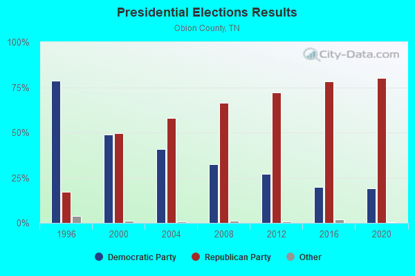
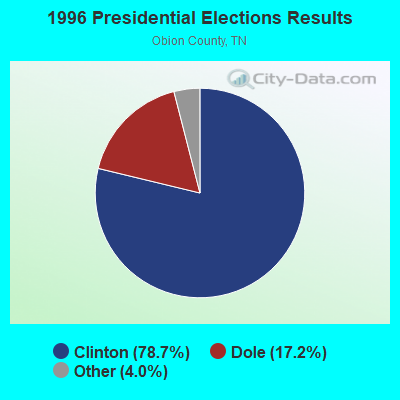
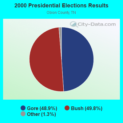
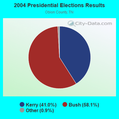
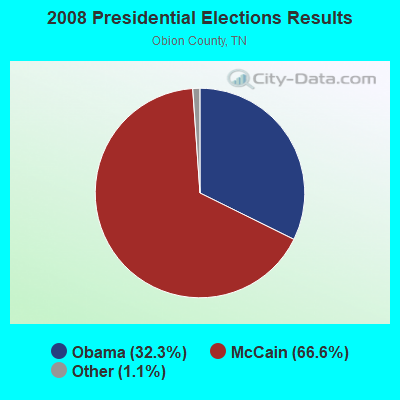
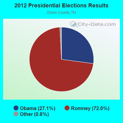
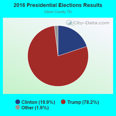
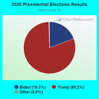
Graphs represent county-level data. Detailed 2008 Election Results
Religion statistics for Kenton-Mason Hall, TN (based on Obion County data)
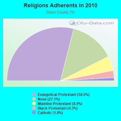
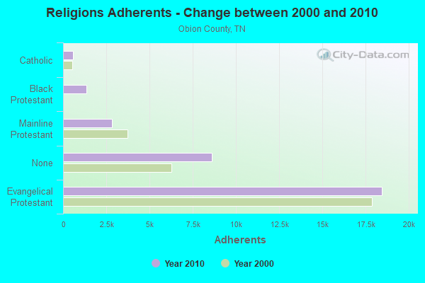
| Religion | Adherents | Congregations |
|---|---|---|
| Evangelical Protestant | 18,444 | 93 |
| Mainline Protestant | 2,845 | 25 |
| Black Protestant | 1,355 | 6 |
| Catholic | 558 | 1 |
| Other | - | 1 |
| None | 8,605 | - |
Food Environment Statistics:
| Obion County: | 1.59 / 10,000 pop. |
| Tennessee: | 1.99 / 10,000 pop. |
| Obion County: | 0.32 / 10,000 pop. |
| Tennessee: | 0.17 / 10,000 pop. |
| Here: | 0.32 / 10,000 pop. |
| State: | 0.65 / 10,000 pop. |
| This county: | 4.76 / 10,000 pop. |
| State: | 5.16 / 10,000 pop. |
| This county: | 7.94 / 10,000 pop. |
| Tennessee: | 6.56 / 10,000 pop. |
| Obion County: | 12.7% |
| Tennessee: | 11.4% |
| Obion County: | 30.9% |
| Tennessee: | 30.2% |
| This county: | 15.1% |
| Tennessee: | 13.5% |
Strongest AM radio stations in Kenton-Mason Hall:
- WCRV (640 AM; 50 kW; COLLIERVILLE, TN; Owner: BOTT BROADCASTING COMPANY/TENNESSEE)
- WDIA (1070 AM; 50 kW; MEMPHIS, TN; Owner: CLEAR CHANNEL BROADCASTING LICENSES, INC.)
- WGSF (1030 AM; 50 kW; MEMPHIS, TN; Owner: FLINN BROADCASTING CORPORATION)
- WMQM (1600 AM; 50 kW; LAKELAND, TN; Owner: WMQM, INC.)
- WSM (650 AM; 50 kW; NASHVILLE, TN; Owner: GAYLORD ENTERTAINMENT COMPANY)
- WENK (1240 AM; 1 kW; UNION CITY, TN; Owner: WENK OF UNION CITY, INC.)
- KOTC (830 AM; daytime; 10 kW; KENNETT, MO; Owner: EAGLE BLUFF ENTERPRISES)
- WKDA (1200 AM; 50 kW; NASHVILLE, TN; Owner: RADIO NASHVILLE, INC.)
- WNQM (1300 AM; 50 kW; NASHVILLE, TN; Owner: WNQM. INC.)
- WMUF (1000 AM; daytime; 5 kW; PARIS, TN; Owner: BENTON-WEATHERFORD B/CTING OF TN,INC)
- WAMB (1160 AM; 50 kW; DONELSON, TN; Owner: GREAT SOUTHERN BROADCASTING COMPANY, INC.)
- KLCN (910 AM; 5 kW; BLYTHEVILLE, AR; Owner: SUDBURY SERVICES, INC.)
- WDXI (1310 AM; 5 kW; JACKSON, TN; Owner: LIBERTY RADIO II, INC.)
Strongest FM radio stations in Kenton-Mason Hall:
- WLSQ-FM (94.3 FM; DYER, TN; Owner: F. DARRELL BOYD)
- WASL (100.1 FM; DYERSBURG, TN; Owner: DR PEPPER PEPSI-COLA BOTTLING CO.)
- WYNU (92.3 FM; MILAN, TN; Owner: CAPSTAR TX LIMITED PARTNERSHIP)
- WWYN (106.9 FM; MCKENZIE, TN; Owner: RAINBOW MEDIA, INC.)
- WTNE-FM (97.7 FM; TRENTON, TN; Owner: GIBSON COUNTY BROADCASTING COMPANY, INC.)
- WCMT-FM (101.7 FM; MARTIN, TN; Owner: THUNDERBOLT BROADCASTING COMPANY)
- WKNQ (90.7 FM; DYERSBURG, TN; Owner: MID-SOUTH PUBLIC COMMS. FOUNDATION)
- W205BN (88.9 FM; DYERSBURG, TN; Owner: WAY-FM MEDIA GROUP, INC.)
- WWKF (99.3 FM; FULTON, KY; Owner: WENK OF UNION CITY, INC.)
- WYVY (104.9 FM; UNION CITY, TN; Owner: TWIN STATES BROADCASTING, INC.)
- WQAK (105.7 FM; UNION CITY, TN; Owner: TWIN STATES BROADCASTING, INC.)
- WCDZ (95.1 FM; DRESDEN, TN; Owner: THUNDERBOLT BROADCASTING COMPANY)
- W202BG (88.3 FM; DYERSBURG, TN; Owner: BIBLE BROADCASTING NETWORK, INC.)
TV broadcast stations around Kenton-Mason Hall:
- WUWT-CA (Channel 9; UNION CITY, TN; Owner: JOSEPH H. HARPOLE, SR.)
- WJKT (Channel 16; JACKSON, TN; Owner: CLEAR CHANNEL BROADCASTING LICENSES, INC.)
- WDYR-CA (Channel 33; DYERSBURG, TN; Owner: TRI-STATE CHRISTIAN TV, INC.)
- W02BT (Channel 2; SHARON, TN; Owner: DAYSTAR MINISTRIES)

- 55.5%Utility gas
- 35.9%Electricity
- 8.6%Bottled, tank, or LP gas

- 63.3%Utility gas
- 32.7%Electricity
- 2.7%No fuel used
- 1.4%Bottled, tank, or LP gas
Kenton-Mason Hall compared to Tennessee state average:
- Median house value below state average.
- Unemployed percentage significantly below state average.
- Black race population percentage significantly below state average.
- Hispanic race population percentage significantly below state average.
- Foreign-born population percentage significantly below state average.
- Renting percentage significantly below state average.
- Length of stay since moving in significantly above state average.
- Number of rooms per house significantly below state average.
- House age significantly below state average.
- Number of college students below state average.
- Percentage of population with a bachelor's degree or higher significantly below state average.