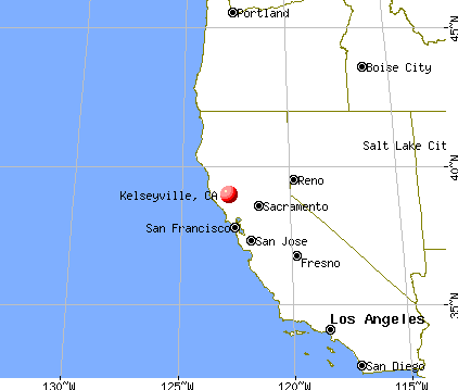
Kelseyville, California
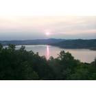
Kelseyville: Sunrise in Kelseyville
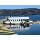
Kelseyville: Konocti Harbor Resort & Spa - Clear Lake

Kelseyville: View from Konocti Harbor Resort & Spa
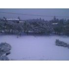
Kelseyville: New Years Day 2011 in the Kelseyville Riveiera
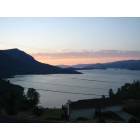
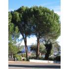
Kelseyville: Mt. Konocti and Clear Lake from Hawaina Way in Kelseyville June 2006
Kelseyville: Konocti Harbor Resort & Spa - Clear Lake
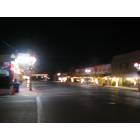
Kelseyville: Down Town Kelseyville holiday season 2006
- add
your
Submit your own pictures of this place and show them to the world
- OSM Map
- General Map
- Google Map
- MSN Map

Population change since 2000: +14.5%
| Males: 1,843 | |
| Females: 1,510 |
| Median resident age: | 29.9 years |
| California median age: | 37.9 years |
Zip codes: 95451.
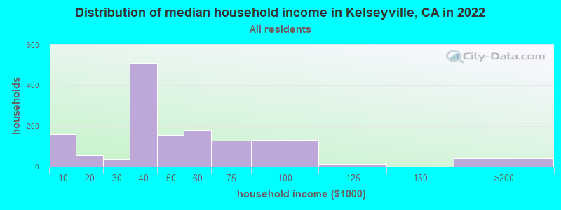
| Kelseyville: | $39,069 |
| CA: | $91,551 |
Estimated per capita income in 2022: $16,884 (it was $15,651 in 2000)
Kelseyville CDP income, earnings, and wages data
Estimated median house or condo value in 2022: $231,874 (it was $89,200 in 2000)
| Kelseyville: | $231,874 |
| CA: | $715,900 |
Mean prices in 2022: all housing units: $232,240; detached houses: $372,624; mobile homes: $57,436
Median gross rent in 2022: $985.
(35.7% for White Non-Hispanic residents, 14.1% for Hispanic or Latino residents, 3.7% for other race residents, 11.0% for two or more races residents)
Detailed information about poverty and poor residents in Kelseyville, CA

Compare current foreclosures near Kelseyville, CA:
| Photo | Address | Area | Beds / Baths | Price | Details |
|---|---|---|---|---|---|

|
#1
Soda Bay Rd
Kelseyville, CA 95451
|
1,808 sq. feet
|
2 baths 2 beds |
$695,000
|
show details |

|
#2
Hilltop Dr
Kelseyville, CA 95451
|
2,023 sq. feet
|
2 baths 3 beds |
show details | |

|
#3
Konocti Rd
Kelseyville, CA 95451
|
1,222 sq. feet
|
1 baths 2 beds |
show details | |

|
#4
Point Lakeview Rd
Kelseyville, CA 95451
|
1,282 sq. feet
|
2 baths 2 beds |
show details | |

|
#5
Salinan Way
Kelseyville, CA 95451
|
1,701 sq. feet
|
2 baths 3 beds |
show details | |

|
#6
Marina View Dr
Kelseyville, CA 95451
|
1,408 sq. feet
|
2 baths 2 beds |
show details | |

|
#7
Fairway Dr
Kelseyville, CA 95451
|
924 sq. feet
|
2 baths 2 beds |
show details | |

|
#8
Plunkett Ln
Kelseyville, CA 95451
|
1,056 sq. feet
|
1 baths 3 beds |
show details | |

|
#9
Hohape Ave
Kelseyville, CA 95451
|
667 sq. feet
|
1 baths 2 beds |
show details | |

|
#10
Bel Air Dr E
Kelseyville, CA 95451
|
11,440 sq. feet
|
2 baths 3 beds |
show details |
| Photo | Address | Area | Beds / Baths | Price | Details |
|---|---|---|---|---|---|

|
#11
Westwood Dr
Kelseyville, CA 95451
|
1,500 sq. feet
|
2 baths 2 beds |
show details | |

|
#12
Hok Has Ha Ln
Kelseyville, CA 95451
|
1,304 sq. feet
|
2 baths 3 beds |
show details | |

|
#13
Fairway Dr
Kelseyville, CA 95451
|
1,264 sq. feet
|
2 baths 2 beds |
show details | |

|
#14
Westlake Ct
Kelseyville, CA 95451
|
2,309 sq. feet
|
3 baths 3 beds |
show details | |

|
#15
Yaquima Dr
Kelseyville, CA 95451
|
1,456 sq. feet
|
2 baths 3 beds |
show details | |

|
#16
Westlake Ct
Kelseyville, CA 95451
|
2,309 sq. feet
|
2 baths 3 beds |
show details | |

|
#17
Del Monte Way
Kelseyville, CA 95451
|
960 sq. feet
|
- baths 2 beds |
show details | |

|
#18
Eastlake Dr
Kelseyville, CA 95451
|
- sq. feet
|
- baths - beds |
show details | |

|
#19
Hok Has Ha Ln # B
Kelseyville, CA 95451
|
- sq. feet
|
- baths - beds |
show details | |

|
#20
State Highway 281 # 5084
Kelseyville, CA 95451
|
- sq. feet
|
- baths - beds |
show details |
| Photo | Address | Area | Beds / Baths | Price | Details |
|---|---|---|---|---|---|

|
#21
State St
Kelseyville, CA 95451
|
- sq. feet
|
- baths - beds |
show details | |

|
#22
11th St
Lakeport, CA 95453
|
746 sq. feet
|
1 baths 3 beds |
$170,000
|
show details |

|
#23
Diamond Rdg
Lower Lake, CA 95457
|
2,742 sq. feet
|
2 baths 2 beds |
show details | |

|
#24
Stonybrook Dr
Clearlake, CA 95422
|
1,264 sq. feet
|
2 baths 3 beds |
show details | |

|
#25
Beach St
Nice, CA 95464
|
1,608 sq. feet
|
3 baths 3 beds |
show details | |

|
#26
Springe Street
Nice, CA 95464
|
2,535 sq. feet
|
3 baths 3 beds |
show details | |

|
#27
Crump Avenue
Nice, CA 95464
|
- sq. feet
|
1 baths 2 beds |
show details | |

|
#28
Hillcrest Ave
Clearlake, CA 95422
|
847 sq. feet
|
1 baths 2 beds |
show details | |

|
#29
Old Highway 53
Clearlake, CA 95422
|
1,060 sq. feet
|
1 baths 2 beds |
show details | |

|
#30
Wilder Ave
Clearlake, CA 95422
|
852 sq. feet
|
1 baths 2 beds |
show details |
| Photo | Address | Area | Beds / Baths | Price | Details |
|---|---|---|---|---|---|

|
#31
Green Ave
Clearlake, CA 95422
|
1,108 sq. feet
|
2 baths 3 beds |
show details | |

|
#32
Konocti Vw
Clearlake, CA 95422
|
1,526 sq. feet
|
2 baths 3 beds |
show details | |

|
#33
40th Ave
Clearlake, CA 95422
|
968 sq. feet
|
1 baths 2 beds |
show details | |

|
#34
Eickhoff Rd
Lakeport, CA 95453
|
1,920 sq. feet
|
2 baths 3 beds |
show details | |

|
#35
First Street
Clearlake Oaks, CA 95423
|
700 sq. feet
|
1 baths 2 beds |
show details | |

|
#36
Gifford Springs Rd
Cobb, CA 95426
|
1,060 sq. feet
|
1 baths 2 beds |
show details | |

|
#37
Bridge Arbor Dr
Upper Lake, CA 95485
|
1,132 sq. feet
|
2 baths 2 beds |
show details | |

|
#38
Bonham Rd
Lower Lake, CA 95457
|
799 sq. feet
|
1 baths 2 beds |
show details | |

|
#39
Bonham Rd
Lower Lake, CA 95457
|
2,176 sq. feet
|
2 baths 3 beds |
show details | |

|
#40
Navajo Trl
Clearlake Oaks, CA 95423
|
2,382 sq. feet
|
3 baths 3 beds |
show details |
| Photo | Address | Area | Beds / Baths | Price | Details |
|---|---|---|---|---|---|

|
#41
Toscana Cir
Cloverdale, CA 95425
|
2,098 sq. feet
|
3 baths 4 beds |
show details | |

|
#42
River Rd
Cloverdale, CA 95425
|
1,212 sq. feet
|
2 baths 2 beds |
show details | |

|
#43
Primrose Ln
Cloverdale, CA 95425
|
2,464 sq. feet
|
3 baths 4 beds |
show details | |

|
#44
Elbridge Ave Apt C
Cloverdale, CA 95425
|
1,135 sq. feet
|
2 baths 2 beds |
show details | |

|
#45
Theresa Dr
Cloverdale, CA 95425
|
1,344 sq. feet
|
1 baths 3 beds |
show details | |

|
#46
Woodland Dr
Clearlake, CA 95422
|
928 sq. feet
|
3 baths 2 beds |
show details | |

|
#47
14th St
Clearlake, CA 95422
|
1,459 sq. feet
|
2 baths 3 beds |
show details | |

|
#48
Harry Way
Lucerne, CA 95458
|
1,266 sq. feet
|
3 baths 3 beds |
show details | |

|
#49
6th St
Lakeport, CA 95453
|
721 sq. feet
|
1 baths 2 beds |
show details | |

|
Check over 1 million property listings on Foreclosure.com!
|
browse all offers | |||


- 2,79972.9%Hispanic
- 1,12229.2%White alone
- 521.4%Black alone
- 120.3%Two or more races

According to our research of California and other state lists, there were 32 registered sex offenders living in Kelseyville, California as of June 02, 2024.
The ratio of all residents to sex offenders in Kelseyville is 121 to 1.
 Recent articles from our blog. Our writers, many of them Ph.D. graduates or candidates, create easy-to-read articles on a wide variety of topics.

 | What can YOU tell me about these Northern California counties? (Any info IS welcomed!) (100 replies) |
| clearklake OAKS livability? (13 replies) |
| Nice Linda Paradise (20 replies) |
| What are the lower cost of living areas in California? (46 replies) |
| Burb Living: Loomis vs. Vacaville vs. Napa vs. Martinez vs. Santa Rosa vs ... ? (21 replies) |
| Working/Living in Clear Lake area (3 replies) |
Latest news from Kelseyville, CA collected exclusively by city-data.com from local newspapers, TV, and radio stations
Kelseyville, CA City Guides:
Ancestries: Irish (6.2%), Scottish (2.2%), Portuguese (2.0%), German (1.8%), Welsh (1.7%), Norwegian (1.1%).
Current Local Time: PST time zone
Elevation: 1386 feet
Land area: 3.23 square miles.
Population density: 1,037 people per square mile (low).
1,064 residents are foreign born (27.6% Latin America).
| This place: | 27.7% |
| California: | 26.5% |
| Kelseyville CDP: | 1.2% ($1,053) |
| California: | 0.8% ($1,564) |
Nearest city with pop. 50,000+: Santa Rosa, CA  (36.9 miles , pop. 147,595).
Nearest city with pop. 200,000+: West Contra Costa, CA (75.6 miles , pop. 236,008).
Nearest city with pop. 1,000,000+: Los Angeles, CA (418.9 miles , pop. 3,694,820).
Nearest cities:
), ), Latitude: 38.97 N, Longitude: 122.83 W
Area code: 707


| Here: | 6.9% |
| California: | 5.1% |
- Health care (10.7%)
- Agriculture, forestry, fishing & hunting (9.8%)
- Educational services (9.8%)
- Administrative & support & waste management services (8.3%)
- Accommodation & food services (8.1%)
- Construction (5.4%)
- Arts, entertainment, recreation (5.3%)
- Agriculture, forestry, fishing & hunting (14.2%)
- Administrative & support & waste management services (13.1%)
- Construction (10.2%)
- Arts, entertainment, recreation (5.7%)
- Accommodation & food services (5.3%)
- Public administration (4.9%)
- Building material & garden equipment & supplies dealers (3.5%)
- Health care (20.0%)
- Educational services (17.2%)
- Accommodation & food services (11.4%)
- Social assistance (7.6%)
- Personal & laundry services (5.3%)
- Finance & insurance (4.9%)
- Agriculture, forestry, fishing & hunting (4.7%)
- Building and grounds cleaning and maintenance occupations (10.1%)
- Agricultural workers, including supervisors (8.1%)
- Preschool, kindergarten, elementary, and middle school teachers (4.7%)
- Secretaries and administrative assistants (4.7%)
- Registered nurses (4.2%)
- Cashiers (3.7%)
- Other office and administrative support workers, including supervisors (3.2%)

- Building and grounds cleaning and maintenance occupations (11.3%)
- Agricultural workers, including supervisors (11.0%)
- Other production occupations, including supervisors (5.7%)
- Electrical equipment mechanics and other installation, maintenance, and repair workers, including supervisors (4.6%)
- Vehicle and mobile equipment mechanics, installers, and repairers (4.6%)
- Other material moving workers, except laborers (3.7%)
- Supervisors, construction and extraction workers (3.5%)
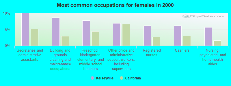
- Secretaries and administrative assistants (10.0%)
- Building and grounds cleaning and maintenance occupations (8.7%)
- Preschool, kindergarten, elementary, and middle school teachers (7.8%)
- Other office and administrative support workers, including supervisors (6.9%)
- Registered nurses (6.2%)
- Cashiers (6.2%)
- Nursing, psychiatric, and home health aides (5.6%)
Average climate in Kelseyville, California
Based on data reported by over 4,000 weather stations


|
|


(lower is better)

Air Quality Index (AQI) level in 2022 was 62.9. This is about average.
| City: | 62.9 |
| U.S.: | 72.6 |

Carbon Monoxide (CO) [ppm] level in 2008 was 0.429. This is significantly worse than average. Closest monitor was 6.4 miles away from the city center.
| City: | 0.429 |
| U.S.: | 0.251 |

Nitrogen Dioxide (NO2) [ppb] level in 2009 was 5.43. This is about average. Closest monitor was 10.0 miles away from the city center.
| City: | 5.43 |
| U.S.: | 5.11 |

Ozone [ppb] level in 2022 was 24.9. This is better than average. Closest monitor was 5.5 miles away from the city center.
| City: | 24.9 |
| U.S.: | 33.3 |

Particulate Matter (PM10) [µg/m3] level in 2022 was 10.5. This is significantly better than average. Closest monitor was 5.5 miles away from the city center.
| City: | 10.5 |
| U.S.: | 19.2 |

Particulate Matter (PM2.5) [µg/m3] level in 2022 was 9.62. This is about average. Closest monitor was 5.5 miles away from the city center.
| City: | 9.62 |
| U.S.: | 8.11 |
Earthquake activity:
Kelseyville-area historical earthquake activity is significantly above California state average. It is 7225% greater than the overall U.S. average.On 4/18/1906 at 13:12:21, a magnitude 7.9 (7.9 UK, Class: Major, Intensity: VIII - XII) earthquake occurred 67.9 miles away from the city center, causing $524,000,000 total damage
On 1/31/1922 at 13:17:28, a magnitude 7.6 (7.6 UK) earthquake occurred 187.5 miles away from the city center
On 4/25/1992 at 18:06:04, a magnitude 7.2 (6.3 MB, 7.1 MS, 7.2 MW, 7.1 MW, Depth: 9.4 mi) earthquake occurred 115.8 miles away from Kelseyville center, causing $75,000,000 total damage
On 10/18/1989 at 00:04:15, a magnitude 7.1 (6.5 MB, 7.1 MS, 6.9 MW, 7.0 ML) earthquake occurred 141.2 miles away from Kelseyville center, causing 62 deaths (62 shaking deaths) and 3757 injuries, causing $1,305,032,704 total damage
On 11/8/1980 at 10:27:34, a magnitude 7.2 (6.2 MB, 7.2 MS, 7.2 MW, 7.0 ML) earthquake occurred 167.0 miles away from the city center
On 1/22/1923 at 09:04:18, a magnitude 7.2 (7.2 UK) earthquake occurred 169.0 miles away from Kelseyville center
Magnitude types: body-wave magnitude (MB), local magnitude (ML), surface-wave magnitude (MS), moment magnitude (MW)
Natural disasters:
The number of natural disasters in Lake County (21) is greater than the US average (15).Major Disasters (Presidential) Declared: 11
Emergencies Declared: 2
Causes of natural disasters: Floods: 13, Storms: 6, Winter Storms: 6, Fires: 5, Landslides: 5, Mudslides: 5, Drought: 1, Heavy Rain: 1, Hurricane: 1, Tornado: 1, Wind: 1, Other: 1 (Note: some incidents may be assigned to more than one category).

Hospitals and medical centers in Kelseyville:
Other hospitals and medical centers near Kelseyville:
- HOSPICE SERVICES OF LAKE COUNTY (Hospital, about 7 miles away; LAKEPORT, CA)
- SUTTER VISITING NURSE ASSOCIATION AND HOSPICE (Home Health Center, about 7 miles away; LAKEPORT, CA)
- EVERGREEN LAKEPORT HEALTHCARE (Nursing Home, about 7 miles away; LAKEPORT, CA)
- ROCKY POINT CARE CENTER (Nursing Home, about 8 miles away; LAKEPORT, CA)
- SUTTER LAKESIDE HOSPITAL Critical Access Hospitals (about 11 miles away; LAKEPORT, CA)
- CLEARLAKE DIALYSIS CENTER (Dialysis Facility, about 11 miles away; CLEARLAKE, CA)
- MEADOWOOD NURSING CENTER (Nursing Home, about 11 miles away; CLEARLAKE, CA)
located in Kelseyville:
See details about located in Kelseyville, CAColleges/universities with over 2000 students nearest to Kelseyville:
- Mendocino College (about 27 miles; Ukiah, CA; Full-time enrollment: 2,263)
- Santa Rosa Junior College (about 37 miles; Santa Rosa, CA; FT enrollment: 13,047)
- Sonoma State University (about 45 miles; Rohnert Park, CA; FT enrollment: 7,796)
- Napa Valley College (about 58 miles; Napa, CA; FT enrollment: 3,780)
- Solano Community College (about 64 miles; Fairfield, CA; FT enrollment: 5,790)
- University of California-Davis (about 66 miles; Davis, CA; FT enrollment: 30,845)
- Yuba College (about 71 miles; Marysville, CA; FT enrollment: 4,737)
Public high schools in Kelseyville:
- KELSEYVILLE HIGH (Students: 343, Location: 5480 MAIN ST., Grades: 9-12)
- KELSEYVILLE COMMUNITY DAY (Students: 7, Location: 3980 GARD ST., Grades: 7-12)
- ED DONALDSON EDUCATION CENTER (Students: 3, Location: 4500 KONOCTI RD., Grades: 9-12)
Public elementary/middle schools in Kelseyville:
- MOUNTAIN VISTA MIDDLE (Students: 389, Location: 5081 KONOCTI RD., Grades: 6-8)
- KELSEYVILLE ELEMENTARY (Students: 287, Location: 5065 KONOCTI RD., Grades: KG-5)
- RIVIERA ELEMENTARY (Students: 173, Location: 10505 FAIRWAY DR., Grades: KG-5)
Points of interest:
Notable location: Kelseyville Fire Protection District Station 55 (A). Display/hide its location on the map
Churches in Kelseyville include: Grace Evangelical Free Church (A), Presbyterian Church of Kelseyville (B), Saint Peter Roman Catholic Church (C). Display/hide their locations on the map
Creek: McIntire Creek (A). Display/hide its location on the map
Birthplace of: Les Webber - Baseball player.
Drinking water stations with addresses in Kelseyville and their reported violations in the past:
BUCKINGHAM PARK WATER DISTRICT (Population served: 1,142, Surface water):Past health violations:BAYVIEW RECREATIONAL PARK (Population served: 30, Groundwater):
- Treatment Technique (SWTR and GWR) - In MAR-2013. Follow-up actions: St Compliance achieved (MAY-01-2013), St AO (w/o penalty) issued (OCT-23-2013)
- Treatment Technique (SWTR and GWR) - In FEB-2013. Follow-up actions: St Compliance achieved (MAY-01-2013), St AO (w/o penalty) issued (OCT-23-2013)
- Treatment Technique (SWTR and GWR) - In JAN-2013. Follow-up actions: St Compliance achieved (MAY-01-2013), St AO (w/o penalty) issued (OCT-23-2013)
- MCL, Average - Between JAN-2006 and MAR-2006, Contaminant: Total Haloacetic Acids (HAA5). Follow-up actions: St Violation/Reminder Notice (NOV-13-2006)
- MCL, Average - Between OCT-2005 and DEC-2005, Contaminant: Total Haloacetic Acids (HAA5). Follow-up actions: St Violation/Reminder Notice (NOV-13-2006)
Past monitoring violations:REEL IN RESORT (Population served: 25, Groundwater):
- Initial Tap Sampling for Pb and Cu - In JUL-01-2002, Contaminant: Lead and Copper Rule. Follow-up actions: St Admin Penalty assessed (JAN-10-2003)
Past monitoring violations:
- Monitoring, Repeat Major (TCR) - In MAR-2014, Contaminant: Coliform (TCR). Follow-up actions: St AO (w/o penalty) issued (MAY-28-2014)
- One regular monitoring violation
Drinking water stations with addresses in Kelseyville that have no violations reported:
- THOMAS WATER SYSTEM (Population served: 100, Primary Water Source Type: Groundwater)
- LODGE AT BLUE LAKES (Population served: 100, Primary Water Source Type: Groundwater)
- BRANDING IRON MUTUAL (Population served: 60, Primary Water Source Type: Groundwater)
- RICHMOND PARK RESORT (Population served: 25, Primary Water Source Type: Surface water)
- INNISFREE WATER COMPANY (Population served: 20, Primary Water Source Type: Groundwater)
| This place: | 2.7 people |
| California: | 2.9 people |
| This place: | 67.2% |
| Whole state: | 68.7% |
| This place: | 7.6% |
| Whole state: | 7.2% |
Likely homosexual households (counted as self-reported same-sex unmarried-partner households)
- Lesbian couples: 0.9% of all households
- Gay men: 0.2% of all households
People in group quarters in Kelseyville in 2000:
- 6 people in hospitals/wards and hospices for chronically ill
- 6 people in hospices or homes for chronically ill
- 5 people in other noninstitutional group quarters
Banks with branches in Kelseyville (2011 data):
- Umpqua Bank: Kelseyville Branch at 4280 Main Street, branch established on 1996/03/11. Info updated 2011/09/02: Bank assets: $11,556.7 mil, Deposits: $9,325.3 mil, headquarters in Roseburg, OR, positive income, Commercial Lending Specialization, 193 total offices, Holding Company: Umpqua Holdings Corporation
- Westamerica Bank: Kelseyville Branch at 4025 Main Street, branch established on 1904/10/17. Info updated 2011/06/21: Bank assets: $4,998.1 mil, Deposits: $4,253.2 mil, headquarters in San Rafael, CA, positive income, Commercial Lending Specialization, 98 total offices, Holding Company: Westamerica Bancorporation
For population 15 years and over in Kelseyville:

- Never married: 38.0%
- Now married: 35.7%
- Separated: 5.0%
- Widowed: 4.2%
- Divorced: 17.0%
For population 25 years and over in Kelseyville:
- High school or higher: 72.5%
- Bachelor's degree or higher: 12.0%
- Graduate or professional degree: 4.1%
- Unemployed: 10.7%
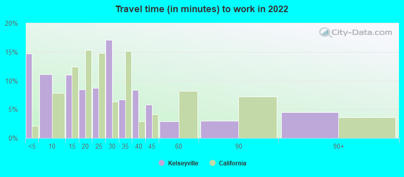
- Mean travel time to work (commute): 27.1 minutes


| Here: | 17.7 |
| California average: | 15.5 |
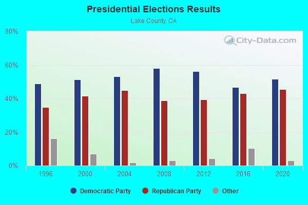
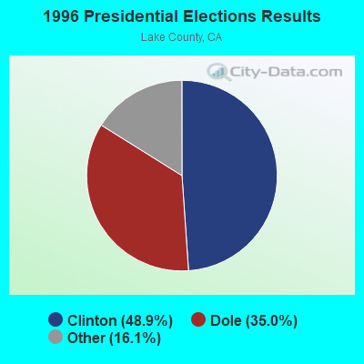
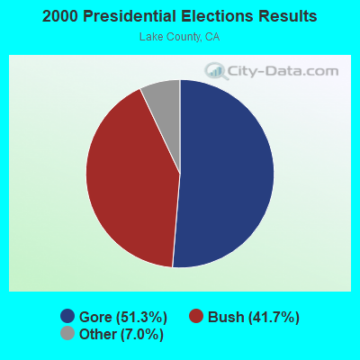
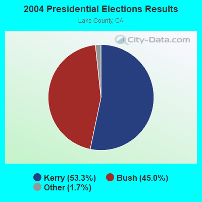
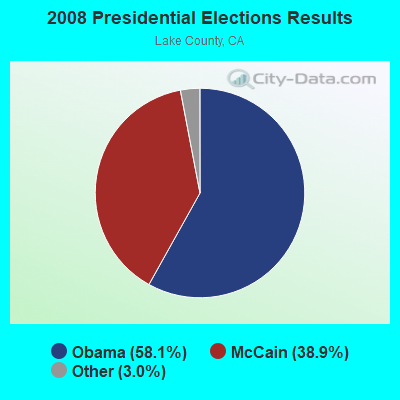

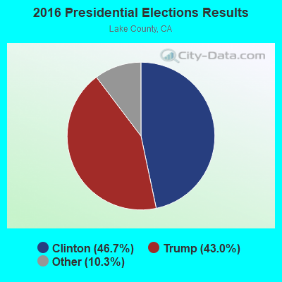
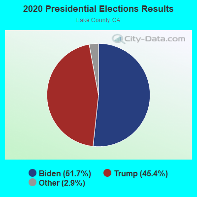
Graphs represent county-level data. Detailed 2008 Election Results
Religion statistics for Kelseyville, CA (based on Lake County data)
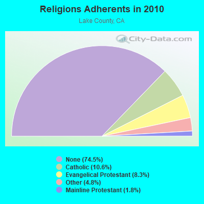
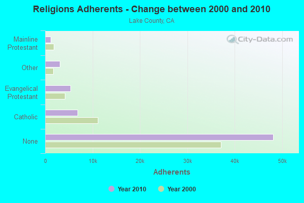
| Religion | Adherents | Congregations |
|---|---|---|
| Catholic | 6,857 | 6 |
| Evangelical Protestant | 5,373 | 44 |
| Other | 3,080 | 16 |
| Mainline Protestant | 1,141 | 14 |
| Orthodox | 50 | 1 |
| None | 48,164 | - |
Food Environment Statistics:
| Lake County: | 3.72 / 10,000 pop. |
| State: | 2.14 / 10,000 pop. |
| This county: | 0.78 / 10,000 pop. |
| California: | 0.62 / 10,000 pop. |
| Lake County: | 3.26 / 10,000 pop. |
| State: | 1.49 / 10,000 pop. |
| This county: | 6.20 / 10,000 pop. |
| State: | 7.42 / 10,000 pop. |
| Lake County: | 8.3% |
| California: | 7.3% |
| Lake County: | 23.7% |
| State: | 21.3% |
| Here: | 14.4% |
| California: | 17.9% |
Health and Nutrition:
| Here: | 47.7% |
| California: | 49.4% |
| Kelseyville: | 44.7% |
| California: | 48.0% |
| Here: | 28.8 |
| California: | 28.1 |
| Here: | 23.0% |
| State: | 20.2% |
| Kelseyville: | 11.0% |
| California: | 11.2% |
| Kelseyville: | 6.8 |
| California: | 6.8 |
| This city: | 34.5% |
| California: | 31.5% |
| Here: | 53.3% |
| State: | 56.4% |
| Kelseyville: | 77.4% |
| State: | 80.9% |
More about Health and Nutrition of Kelseyville, CA Residents
| Businesses in Kelseyville, CA | ||||
| Name | Count | Name | Count | |
|---|---|---|---|---|
| FedEx | 1 | U-Haul | 2 | |
| MasterBrand Cabinets | 5 | UPS | 1 | |
Strongest AM radio stations in Kelseyville:
- KXBX (1270 AM; 0 kW; LAKEPORT, CA; Owner: BICOASTAL MEDIA LLC)
- KCBS (740 AM; 50 kW; SAN FRANCISCO, CA; Owner: INFINITY BROADCASTING OPERATIONS, INC.)
- KTRB (860 AM; 50 kW; MODESTO, CA; Owner: PAPPAS RADIO OF CALIFORNIA, A CALIFORNIA LIMITED PARTNERSHIP)
- KNBR (680 AM; 50 kW; SAN FRANCISCO, CA; Owner: KNBR LICO, INC.)
- KFBK (1530 AM; 50 kW; SACRAMENTO, CA; Owner: AMFM RADIO LICENSES, L.L.C.)
- KGO (810 AM; 50 kW; SAN FRANCISCO, CA; Owner: KGO-AM RADIO, INC.)
- KFIA (710 AM; 25 kW; CARMICHAEL, CA; Owner: VISTA BROADCASTING INC.)
- KTCT (1050 AM; 50 kW; SAN MATEO, CA; Owner: SUSQUEHANNA RADIO CORP.)
- KIQI (1010 AM; 35 kW; SAN FRANCISCO, CA; Owner: RADIO UNICA OF SAN FRANCISCO LICENSE CORP.)
- KHTK (1140 AM; 50 kW; SACRAMENTO, CA; Owner: INFINITY RADIO SUBSIDIARY OPERATIONS INC.)
- KFAX (1100 AM; 50 kW; SAN FRANCISCO, CA; Owner: GOLDEN GATE BROADCASTING CO, INC.)
- KSTE (650 AM; 25 kW; RANCHO CORDOVA, CA; Owner: AMFM RADIO LICENSES, L.L.C.)
- KCBC (770 AM; 50 kW; RIVERBANK, CA; Owner: KIERTRON, INC.)
Strongest FM radio stations in Kelseyville:
- KXBX-FM (98.3 FM; LAKEPORT, CA; Owner: BICOASTAL MEDIA LLC)
- K242AH (96.3 FM; KELSEYVILLE, CA; Owner: MOON BROADCASTING UKIAH, LLC)
- KFGY (92.9 FM; HEALDSBURG, CA; Owner: MAVERICK MEDIA OF SANTA ROSA LICENSE LLC)
- KWNE (94.5 FM; UKIAH, CA; Owner: BROADCASTING CORP. OF MENDICINO CTY.)
- KRCB-FM (91.1 FM; SANTA ROSA, CA; Owner: RURAL CALIFORNIA BROADCASTING CORP.)
- KQPM (105.9 FM; UKIAH, CA; Owner: BICOASTAL MEDIA LLC)
- KNDL (89.9 FM; ANGWIN, CA; Owner: HOWELL MOUNTAIN BROADCASTING COMPANY)
- KLVR (91.9 FM; SANTA ROSA, CA; Owner: EDUCATIONAL MEDIA FOUNDATION)
- K296ES (107.1 FM; LAKEPORT, CA; Owner: MOON BROADCASTING UKIAH, LLC)
- KNTI (99.5 FM; LAKEPORT, CA; Owner: BICOASTAL MEDIA LLC)
- KXTS (100.9 FM; CALISTOGA, CA; Owner: SINCLAIR TELECABLE, INC.)
- KBBF (89.1 FM; SANTA ROSA, CA; Owner: BILINGUAL B/CING. FOUNDATION, INC.)
- KSXY (98.7 FM; MIDDLETOWN, CA; Owner: COMMONWEALTH BROADCASTING, LLC)
- K242AD (96.3 FM; BOONVILLE, CA; Owner: MOON BROADCASTING UKIAH, LLC)
- KRSH (95.9 FM; HEALDSBURG, CA; Owner: DEAS COMMUNICATIONS, INC.)
- KUKI-FM (103.3 FM; UKIAH, CA; Owner: MOON BROADCASTING UKIAH, LLC)
- KPRA (89.5 FM; UKIAH, CA; Owner: FAMILY STATIONS, INC.)
- KZYZ (91.5 FM; WILLITS, CA; Owner: MENDOCINO COUNTY PUBLIC BROADCASTING)
- KZYX (90.7 FM; PHILO, CA; Owner: MENDOCINO COUNTY PUBLIC BROADCASTING)
- KSRT (107.1 FM; CLOVERDALE, CA; Owner: POINT BROADCASTING)
TV broadcast stations around Kelseyville:
- K15FJ (Channel 15; LAKEPORT, CA; Owner: THE LAKE COUNTY TELEVISION CLUB)
- K26GK (Channel 26; LAKEPORT, CA; Owner: THE LAKE COUNTY TELEVISION CLUB)
- K33CH (Channel 33; LAKEPORT, CA; Owner: THE LAKE COUNTY TELEVISION CLUB)
- K64AZ (Channel 64; LAKEPORT, CA; Owner: THE LAKE COUNTY TELEVISION CLUB)
- K46DR (Channel 46; LAKEPORT, CA; Owner: THE LAKE COUNTY TELEVISION CLUB)
- K54CY (Channel 54; LAKEPORT, CA; Owner: THE LAKE COUNTY TELEVISION CLUB)
- K52AJ (Channel 52; LAKEPORT, ETC., CA; Owner: THE LAKE COUNTY TELEVISION CLUB)
- K56AW (Channel 56; LAKEPORT, CA; Owner: THE LAKE COUNTY TELEVISION CLUB)
- K58AW (Channel 58; LAKEPORT, CA; Owner: THE LAKE COUNTY TELEVISION CLUB)

Kelseyville fatal accident list:
Nov 9, 2019 05:44 PM, Sr-29, Main St, Lat: 38.971106, Lon: -122.830364, Vehicles: 2, Persons: 2, Fatalities: 1
May 10, 2018 05:25 AM, Sr-29, Lat: 38.945697, Lon: -122.818008, Vehicles: 1, Persons: 2, Fatalities: 1
Dec 7, 2013 04:50 PM, Sr-29, Lat: 38.958200, Lon: -122.827539, Vehicles: 2, Persons: 2, Fatalities: 1, Drunk persons involved: 1
Apr 6, 2011 12:45 AM, Sr-29, Lat: 38.960119, Lon: -122.827061, Vehicles: 2, Persons: 3, Fatalities: 1
Aug 26, 2007 08:43 PM, Sr-29, Lat: 38.974025, Lon: -122.837019, Vehicles: 2, Persons: 5, Fatalities: 1, Drunk persons involved: 1
Feb 27, 2006 08:30 AM, Sr-29, Lat: 38.945170, Lon: -122.816760, Vehicles: 2, Persons: 4, Fatalities: 1
- National Bridge Inventory (NBI) Statistics
- 19Number of bridges
- 180ft / 55.0mTotal length
- 67,186Total average daily traffic
- 3,096Total average daily truck traffic
- 108,217Total future (year 2040) average daily traffic

- New bridges - historical statistics
- 21940-1949
- 31950-1959
- 101960-1969
- 21970-1979
- 11980-1989
- 12000-2009
FCC Registered Antenna Towers: 7 (See the full list of FCC Registered Antenna Towers)
FCC Registered Broadcast Land Mobile Towers: 19 (See the full list of FCC Registered Broadcast Land Mobile Towers in Kelseyville, CA)
FCC Registered Microwave Towers: 17 (See the full list of FCC Registered Microwave Towers in this town)
FCC Registered Amateur Radio Licenses: 130 (See the full list of FCC Registered Amateur Radio Licenses in Kelseyville)
FAA Registered Aircraft: 16 (See the full list of FAA Registered Aircraft in Kelseyville)
2002 - 2018 National Fire Incident Reporting System (NFIRS) incidents
- Fire incident types reported to NFIRS in Kelseyville, CA
- 26852.7%Outside Fires
- 13326.1%Structure Fires
- 7314.3%Mobile Property/Vehicle Fires
- 356.9%Other
 According to the data from the years 2002 - 2018 the average number of fire incidents per year is 30. The highest number of fires - 65 took place in 2013, and the least - 0 in 2003. The data has a dropping trend.
 When looking into fire subcategories, the most incidents belonged to: Outside Fires (52.7%), and Structure Fires (26.1%).
| Most common first names in Kelseyville, CA among deceased individuals | ||
| Name | Count | Lived (average) |
|---|---|---|
| Robert | 77 | 73.7 years |
| John | 68 | 75.8 years |
| William | 67 | 74.5 years |
| James | 57 | 75.0 years |
| Mary | 56 | 81.7 years |
| Charles | 48 | 76.1 years |
| George | 28 | 73.1 years |
| Dorothy | 27 | 78.8 years |
| Richard | 26 | 74.9 years |
| Helen | 26 | 81.9 years |
| Most common last names in Kelseyville, CA among deceased individuals | ||
| Last name | Count | Lived (average) |
|---|---|---|
| Smith | 36 | 78.4 years |
| Johnson | 23 | 77.2 years |
| Davis | 17 | 78.1 years |
| Williams | 16 | 76.5 years |
| Jones | 16 | 80.4 years |
| Wright | 15 | 81.5 years |
| Brown | 14 | 72.2 years |
| Hall | 10 | 68.5 years |
| Wilson | 10 | 80.0 years |
| Anderson | 10 | 69.2 years |

- 41.1%Electricity
- 17.1%Fuel oil, kerosene, etc.
- 15.5%Wood
- 13.3%Other fuel
- 7.1%Bottled, tank, or LP gas
- 3.1%Utility gas
- 2.8%Solar energy

- 56.7%Electricity
- 19.5%Bottled, tank, or LP gas
- 11.8%Wood
- 9.2%Utility gas
- 2.8%Fuel oil, kerosene, etc.
Kelseyville compared to California state average:
- Median household income significantly below state average.
- Median house value significantly below state average.
- Black race population percentage significantly below state average.
- Hispanic race population percentage above state average.
- Median age above state average.
- Length of stay since moving in significantly above state average.
- House age below state average.
- Number of college students below state average.
- Percentage of population with a bachelor's degree or higher below state average.
Kelseyville on our top lists:
- #36 on the list of "Top 101 cities with the largest percentage of people in hospices or homes for chronically ill (population 1,000+)"
- #7 on the list of "Top 101 counties with the lowest Particulate Matter (PM2.5) Annual air pollution readings in 2012 (µg/m3)"
- #24 on the list of "Top 101 counties with the smallest number of children under 18 without health insurance coverage in 2000 (pop. 50,000+)"
- #32 on the list of "Top 101 counties with the highest number of deaths per 1000 residents 2007-2013 (pop. 50,000+)"
- #44 on the list of "Top 101 counties with highest percentage of residents voting for 3rd party candidates in the 2012 Presidential Election"

|
|
Total of 14 patent applications in 2008-2024.