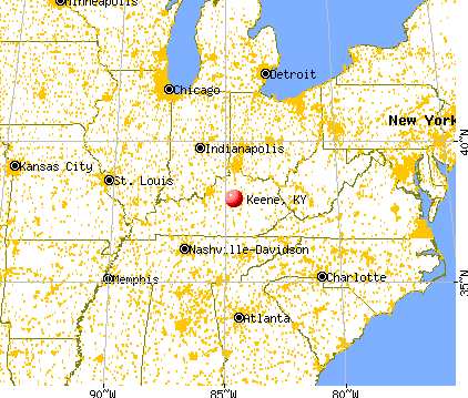
Keene, Kentucky
Submit your own pictures of this place and show them to the world
- OSM Map
- General Map
- Google Map
- MSN Map

| Males: 2,333 | |
| Females: 2,237 |
| Median resident age: | 40.9 years |
| Kentucky median age: | 35.9 years |
Zip code: 40356
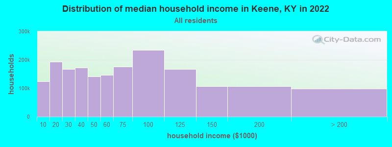
| Keene: | $125,675 |
| KY: | $59,341 |
Estimated per capita income in 2022: $67,402 (it was $33,223 in 2000)
Keene CCD income, earnings, and wages data
Estimated median house or condo value in 2022: $565,746 (it was $221,900 in 2000)
| Keene: | $565,746 |
| KY: | $196,300 |
Detailed information about poverty and poor residents in Keene, KY


- 3,68793.7%White alone
- 1533.9%Black alone
- 360.9%Hispanic
- 270.7%Asian alone
- 230.6%Two or more races
- 50.1%American Indian alone
- 20.05%Other race alone

Races in Keene detailed stats: ancestries, foreign born residents, place of birth
 Recent articles from our blog. Our writers, many of them Ph.D. graduates or candidates, create easy-to-read articles on a wide variety of topics.
Current Local Time: EST time zone
Incorporated on 03/02/1844
Elevation: 911 feet
Land area: 42.9 square miles.
Population density: 106 people per square mile (very low).
| Keene CCD: | 0.7% ($1,483) |
| Kentucky: | 0.8% ($610) |
Nearest city with pop. 50,000+: Fayette, KY  (8.6 miles , pop. 260,512).
Nearest city with pop. 1,000,000+: Chicago, IL (314.3 miles , pop. 2,896,016).
Nearest cities:
), ), Latitude: 37.95 N, Longitude: 84.62 W
Area code commonly used in this area: 859

| Here: | 3.2% |
| Kentucky: | 3.8% |

- Educational services (12.5%)
- Health care (11.9%)
- Construction (9.2%)
- Professional, scientific, technical services (6.8%)
- Accommodation & food services (5.6%)
- Finance & insurance (3.8%)
- Religious, grantmaking, civic, professional, similar organizations (3.6%)

- Construction (13.0%)
- Professional, scientific, technical services (8.5%)
- Educational services (8.2%)
- Health care (5.9%)
- Agriculture, forestry, fishing & hunting (4.5%)
- Transportation equipment (4.2%)
- Accommodation & food services (3.7%)

- Health care (19.9%)
- Educational services (18.2%)
- Accommodation & food services (8.2%)
- Finance & insurance (6.5%)
- Professional, scientific, technical services (4.6%)
- Religious, grantmaking, civic, professional, similar organizations (4.1%)
- Construction (4.0%)

- Other management occupations, except farmers and farm managers (7.2%)
- Other sales and related occupations, including supervisors (5.9%)
- Top executives (5.5%)
- Registered nurses (4.4%)
- Engineers (4.3%)
- Preschool, kindergarten, elementary, and middle school teachers (4.0%)
- Building and grounds cleaning and maintenance occupations (3.4%)

- Other management occupations, except farmers and farm managers (8.7%)
- Other sales and related occupations, including supervisors (7.1%)
- Engineers (6.9%)
- Top executives (6.9%)
- Driver/sales workers and truck drivers (4.4%)
- Building and grounds cleaning and maintenance occupations (4.1%)
- Supervisors, construction and extraction workers (3.8%)

- Preschool, kindergarten, elementary, and middle school teachers (8.8%)
- Registered nurses (7.7%)
- Secretaries and administrative assistants (7.4%)
- Other office and administrative support workers, including supervisors (6.1%)
- Other management occupations, except farmers and farm managers (5.2%)
- Other teachers, instructors, education, training, and library occupations (4.6%)
- Other sales and related occupations, including supervisors (4.4%)
Average climate in Keene, Kentucky
Based on data reported by over 4,000 weather stations


(lower is better)

Air Quality Index (AQI) level in 2022 was 64.2. This is about average.
| City: | 64.2 |
| U.S.: | 72.6 |

Carbon Monoxide (CO) [ppm] level in 2002 was 0.0391. This is significantly better than average. Closest monitor was 7.7 miles away from the city center.
| City: | 0.0391 |
| U.S.: | 0.2513 |

Nitrogen Dioxide (NO2) [ppb] level in 2022 was 6.38. This is worse than average. Closest monitor was 6.2 miles away from the city center.
| City: | 6.38 |
| U.S.: | 5.11 |

Sulfur Dioxide (SO2) [ppb] level in 2022 was 1.10. This is better than average. Closest monitor was 4.3 miles away from the city center.
| City: | 1.10 |
| U.S.: | 1.51 |

Ozone [ppb] level in 2022 was 33.0. This is about average. Closest monitor was 4.3 miles away from the city center.
| City: | 33.0 |
| U.S.: | 33.3 |

Particulate Matter (PM2.5) [µg/m3] level in 2022 was 7.97. This is about average. Closest monitor was 8.5 miles away from the city center.
| City: | 7.97 |
| U.S.: | 8.11 |
Tornado activity:
Keene-area historical tornado activity is near Kentucky state average. It is 32% greater than the overall U.S. average.
On 4/3/1974, a category F4 (max. wind speeds 207-260 mph) tornado 17.1 miles away from the Keene place center killed 7 people and injured 28 people.
On 4/3/1974, a category F4 tornado 25.7 miles away from the place center killed 4 people and injured 122 people and caused between $50,000 and $500,000 in damages.
Earthquake activity:
Keene-area historical earthquake activity is significantly above Kentucky state average. It is 77% greater than the overall U.S. average.On 7/27/1980 at 18:52:21, a magnitude 5.2 (5.1 MB, 4.7 MS, 5.0 UK, 5.2 UK, Class: Moderate, Intensity: VI - VII) earthquake occurred 40.7 miles away from the city center
On 4/18/2008 at 09:36:59, a magnitude 5.4 (5.1 MB, 4.8 MS, 5.4 MW, 5.2 MW) earthquake occurred 181.1 miles away from the city center
On 9/7/1988 at 02:28:09, a magnitude 4.6 (4.5 MB, 4.6 LG, Class: Light, Intensity: IV - V) earthquake occurred 42.4 miles away from Keene center
On 4/18/2008 at 09:36:59, a magnitude 5.2 (5.2 MW, Depth: 8.9 mi) earthquake occurred 181.1 miles away from Keene center
On 6/10/1987 at 23:48:54, a magnitude 5.1 (4.9 MB, 4.4 MS, 4.6 MS, 5.1 LG) earthquake occurred 187.2 miles away from Keene center
On 6/18/2002 at 17:37:15, a magnitude 5.0 (4.3 MB, 4.6 MW, 5.0 LG) earthquake occurred 172.5 miles away from the city center
Magnitude types: regional Lg-wave magnitude (LG), body-wave magnitude (MB), surface-wave magnitude (MS), moment magnitude (MW)
Natural disasters:
The number of natural disasters in Jessamine County (17) is near the US average (15).Major Disasters (Presidential) Declared: 13
Emergencies Declared: 3
Causes of natural disasters: Storms: 9, Floods: 8, Tornadoes: 5, Winter Storms: 5, Mudslides: 3, Blizzard: 1, Freeze: 1, Hurricane: 1, Landslide: 1, Snow: 1, Snowfall: 1, Snowstorm: 1, Other: 1 (Note: some incidents may be assigned to more than one category).
Hospitals and medical centers near Keene:
- ROYAL MANOR (Nursing Home, about 6 miles away; NICHOLASVILLE, KY)
- WESLEY VILLAGE (Nursing Home, about 6 miles away; WILMORE, KY)
- JESSAMINE CO HOSPICE (Hospital, about 6 miles away; NICHOLASVILLE, KY)
- HOSPICE OF THE BLUEGRASS, INC (Hospital, about 7 miles away; LEXINGTON, KY)
- SAYRE CHRISTIAN VILLAGE (Nursing Home, about 7 miles away; LEXINGTON, KY)
- SAYRE CHRISTIAN VILLAGE NURSING HOME (Nursing Home, about 7 miles away; LEXINGTON, KY)
- CARETENDERS (Home Health Center, about 7 miles away; LEXINGTON, KY)
Colleges/universities with over 2000 students nearest to Keene:
- Bluegrass Community and Technical College (about 9 miles; Lexington, KY; Full-time enrollment: 8,560)
- University of Kentucky (about 9 miles; Lexington, KY; FT enrollment: 23,517)
- Kentucky State University (about 22 miles; Frankfort, KY; FT enrollment: 2,112)
- Eastern Kentucky University (about 23 miles; Richmond, KY; FT enrollment: 13,525)
- Campbellsville University (about 59 miles; Campbellsville, KY; FT enrollment: 2,948)
- Sullivan University (about 61 miles; Louisville, KY; FT enrollment: 5,129)
- Somerset Community College (about 62 miles; Somerset, KY; FT enrollment: 4,698)
Points of interest:
Notable locations in Keene: Connemara Golf Course (A), Equestrian Woods Horse Farm (B), Nicholasville City Fire Department Station 3 (C), Jessamine County Fire Department Station 5 (D), Jessamine County Fire Department Station 6 (E). Display/hide their locations on the map
Cemeteries: Blue Grass Memorial Gardens (1), Ebenezer Cemetery (2). Display/hide their locations on the map
Creek: Sinking Creek (A). Display/hide its location on the map
| This place: | 2.8 people |
| Kentucky: | 2.5 people |
| This place: | 84.6% |
| Whole state: | 66.9% |
| This place: | 3.0% |
| Whole state: | 6.4% |
Likely homosexual households (counted as self-reported same-sex unmarried-partner households)
- Lesbian couples: 0.6% of all households
- Gay men: 0.2% of all households
| This place: | 3.2% |
| Whole state: | 15.8% |
| This place: | 2.0% |
| Whole state: | 6.6% |
For population 15 years and over in Keene:

- Never married: 18.7%
- Now married: 73.9%
- Separated: 1.7%
- Widowed: 3.3%
- Divorced: 4.1%
For population 25 years and over in Keene:
- High school or higher: 86.7%
- Bachelor's degree or higher: 39.0%
- Graduate or professional degree: 15.7%
- Unemployed: 2.2%
- Mean travel time to work (commute): 24.6 minutes


| Here: | 12.2 |
| Kentucky average: | 13.8 |
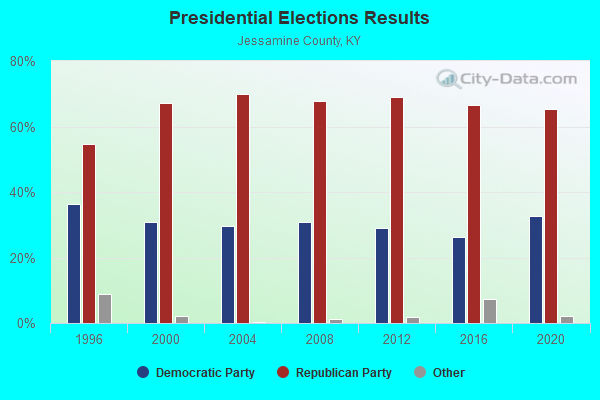
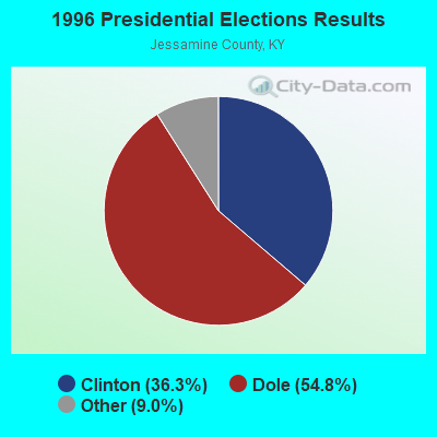


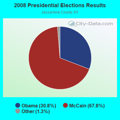
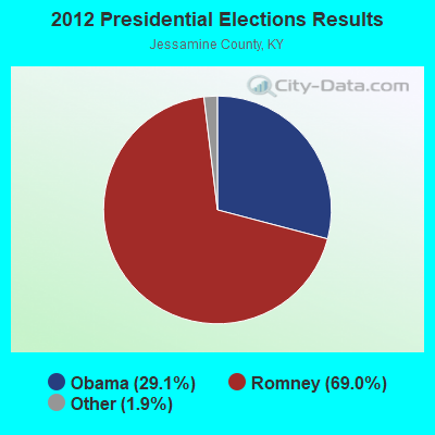
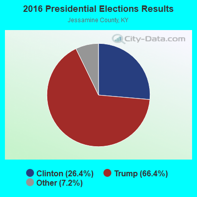
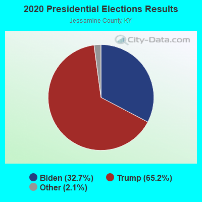
Graphs represent county-level data. Detailed 2008 Election Results
Religion statistics for Keene, KY (based on Jessamine County data)
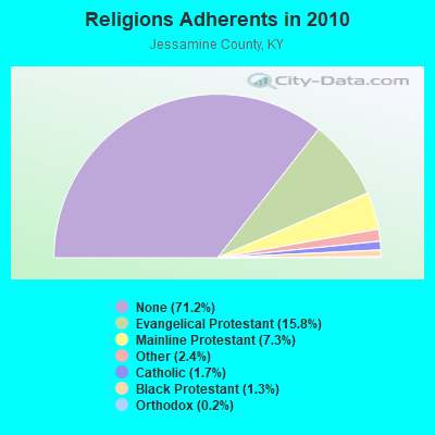
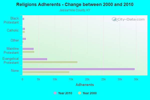
| Religion | Adherents | Congregations |
|---|---|---|
| Evangelical Protestant | 7,679 | 31 |
| Mainline Protestant | 3,553 | 15 |
| Other | 1,173 | 3 |
| Catholic | 820 | 1 |
| Black Protestant | 626 | 2 |
| Orthodox | 120 | 1 |
| None | 34,615 | - |
Food Environment Statistics:
| Jessamine County: | 1.10 / 10,000 pop. |
| State: | 2.19 / 10,000 pop. |
| Jessamine County: | 0.22 / 10,000 pop. |
| State: | 0.25 / 10,000 pop. |
| Jessamine County: | 0.66 / 10,000 pop. |
| Kentucky: | 0.74 / 10,000 pop. |
| Here: | 3.95 / 10,000 pop. |
| Kentucky: | 4.36 / 10,000 pop. |
| This county: | 4.83 / 10,000 pop. |
| Kentucky: | 5.74 / 10,000 pop. |
| Jessamine County: | 10.9% |
| Kentucky: | 11.0% |
| Jessamine County: | 25.8% |
| State: | 30.0% |
| Jessamine County: | 11.8% |
| Kentucky: | 15.9% |
Strongest AM radio stations in Keene:
- WVLK (590 AM; 5 kW; LEXINGTON, KY; Owner: CUMULUS LICENSING CORP.)
- WLAP (630 AM; 5 kW; LEXINGTON, KY; Owner: CITICASTERS LICENSES, L.P.)
- WCGW (770 AM; daytime; 1 kW; NICHOLASVILLE, KY; Owner: MORTENSON BROADCASTING COMPANY)
- WXRA (1580 AM; 10 kW; GEORGETOWN, KY; Owner: CITICASTERS LICENSES, L.P.)
- WHAS (840 AM; 50 kW; LOUISVILLE, KY; Owner: CLEAR CHANNEL BROADCASTING LICENSES, INC.)
- WWFT (1250 AM; 0 kW; NICHOLASVILLE, KY)
- WLXG (1300 AM; 2 kW; LEXINGTON, KY; Owner: L.M. COMMUNICATIONS, INC)
- WLW (700 AM; 50 kW; CINCINNATI, OH; Owner: JACOR BROADCASTING CORPORATION)
- WSAI (1530 AM; 50 kW; CINCINNATI, OH; Owner: JACOR BROADCASTING CORPORATION)
- WTVN (610 AM; 50 kW; COLUMBUS, OH; Owner: CITICASTERS LICENSES, L.P.)
- WKVL (850 AM; daytime; 50 kW; KNOXVILLE, TN; Owner: HORNE RADIO, LLC)
- WMJR (1380 AM; 2 kW; WINCHESTER, KY; Owner: THY KINGDOM COME NETWORK, INC)
- WXXA (790 AM; 5 kW; LOUISVILLE, KY)
Strongest FM radio stations in Keene:
- WLTO (102.5 FM; NICHOLASVILLE, KY; Owner: CUMULUS LICENSING CORP.)
- WVRB (95.3 FM; WILMORE, KY; Owner: VERNON R. BALDWIN, INC.)
- WUKY (91.3 FM; LEXINGTON, KY; Owner: BD. OF TRUSTEES UNIV. OF KENTUCKY)
- WJMM-FM (99.3 FM; HARRODSBURG, KY; Owner: MORTENSON BROADCASTING COMPANY OF CENTRAL KENTUCKY, LLC)
- WVLK-FM (92.9 FM; LEXINGTON, KY; Owner: CUMULUS LICENSING CORP.)
- WXZZ (103.3 FM; GEORGETOWN, KY; Owner: CUMULUS LICENSING CORP.)
- WBUL-FM (98.1 FM; LEXINGTON, KY; Owner: CITICASTERS LICENSES, L.P.)
- WCDA (106.3 FM; VERSAILLES, KY; Owner: L.M. COMMUNICATIONS, INC)
- WEKU (88.9 FM; RICHMOND, KY; Owner: EASTERN KENTUCKY UNIVERSITY)
- WKQQ (100.1 FM; WINCHESTER, KY; Owner: CITICASTERS LICENSES, L.P.)
- WMXL (94.5 FM; LEXINGTON, KY; Owner: CITICASTERS LICENSES, INC.)
- WRFL (88.1 FM; LEXINGTON, KY; Owner: UN OF KENTUCKY BD OF TRUSTEES)
- WLRO (101.5 FM; RICHMOND, KY; Owner: CUMULUS LICENSING CORP.)
- WLKT (104.5 FM; LEXINGTON-FAYETTE, KY; Owner: CITICASTERS LICENSES, L.P.)
- WGKS (96.9 FM; PARIS, KY; Owner: L.M. COMMUNICATIONS, INC.)
- WBTF (107.9 FM; MIDWAY, KY; Owner: L.M. COMMUNICATIONS OF KENTUCKY, LLC)
- WHIR-FM (107.1 FM; DANVILLE, KY; Owner: CLEAR CHANNEL BROADCASTING LICENSES, INC.)
- WRVG-FM (89.9 FM; GEORGETOWN, KY; Owner: GEORGETOWN COLLEGE)
- WKYL (102.1 FM; LAWRENCEBURG, KY; Owner: DAVENPORT BROADCASTING, INC.)
- WXKY-FM (96.3 FM; STANFORD, KY; Owner: LINCOLN-GARRARD BROADCASTING CO.,INC)
TV broadcast stations around Keene:
- WDKY-TV (Channel 56; DANVILLE, KY; Owner: WDKY LICENSEE, LLC)
- WKYT-TV (Channel 27; LEXINGTON, KY; Owner: WKYT LICENSEE CORP.)
- WTVQ-TV (Channel 36; LEXINGTON, KY; Owner: MEDIA GENERAL COMMUNICATIONS, INC.)
- WKLE (Channel 46; LEXINGTON, KY; Owner: KENTUCKY AUTHORITY FOR EDUCATIONAL TV)
- WLEX-TV (Channel 18; LEXINGTON, KY; Owner: WLEX COMMUNICATIONS, L.L.C.)
- WAVE (Channel 3; LOUISVILLE, KY; Owner: LIBCO, INC.)
FCC Registered Cell Phone Towers:
2 (See the full list of FCC Registered Cell Phone Towers in Keene)FCC Registered Antenna Towers:
11 (See the full list of FCC Registered Antenna Towers)FCC Registered Microwave Towers:
1- KEENE, 1527 Woods Road Rd #1 (Lat: 37.965917 Lon: -84.647444), Type: Tower, Structure height: 85.3 m, Overall height: 89 m, Call Sign: WLK757,
Assigned Frequencies: 6093.45 MHz, Grant Date: 01/26/2021, Expiration Date: 02/01/2031, Certifier: John T Scott Iii, Registrant: Verizon Wireless, 5055 North Point Pkwy, Np2ne Network Engineering, Alpharetta, GA 30022, Phone: (770) 797-1070, Email:
FCC Registered Amateur Radio Licenses:
2- Call Sign: KW4KT, Licensee ID: L01951735, Grant Date: 06/22/2015, Expiration Date: 06/22/2025, Cancellation Date: 08/11/2015, Certifier: Sean P Foley, Registrant: Sean P Foley, Keene, KY 40339
- Call Sign: AC4H, Previous Call Sign: KW4KT, Licensee ID: L01951735, Grant Date: 08/11/2015, Expiration Date: 08/11/2025, Certifier: Sean P Foley, Registrant: Sean P Foley, Keene, KY 40339
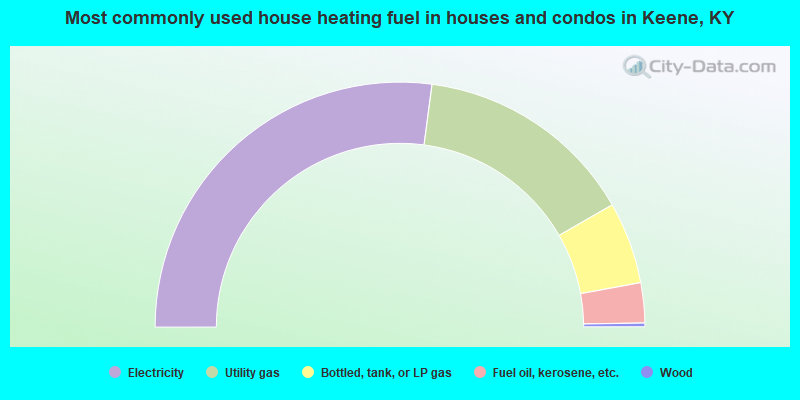
- 54.2%Electricity
- 29.2%Utility gas
- 10.8%Bottled, tank, or LP gas
- 5.3%Fuel oil, kerosene, etc.
- 0.5%Wood
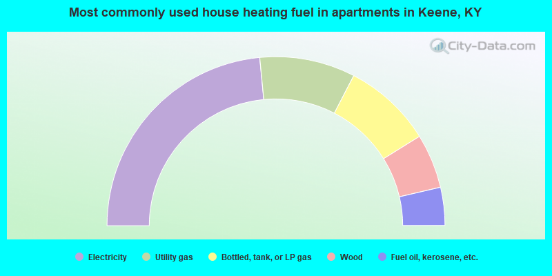
- 47.0%Electricity
- 18.3%Utility gas
- 17.1%Bottled, tank, or LP gas
- 10.4%Wood
- 7.3%Fuel oil, kerosene, etc.
Keene compared to Kentucky state average:
- Median household income above state average.
- Median house value significantly above state average.
- Unemployed percentage significantly below state average.
- Black race population percentage below state average.
- Hispanic race population percentage significantly below state average.
- Foreign-born population percentage significantly below state average.
- Renting percentage significantly below state average.
- Length of stay since moving in significantly above state average.
- Number of rooms per house significantly below state average.
- House age significantly below state average.
- Percentage of population with a bachelor's degree or higher above state average.

|
Total of 1 patent application in 2008-2024.