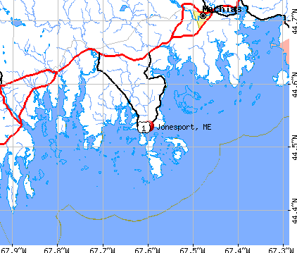
Jonesport, Maine
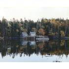
Jonesport: Fall Foliage of Charlie's Creek
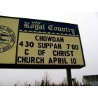
Jonesport: True Downeastah.

Jonesport: Downeastah
- add
your
Submit your own pictures of this town and show them to the world
- OSM Map
- General Map
- Google Map
- MSN Map
Population change since 2000: -2.7%
 |
| Males: 662 | |
| Females: 708 |
| Median resident age: | 49.0 years |
| Maine median age: | 43.0 years |
Zip codes: 04649.
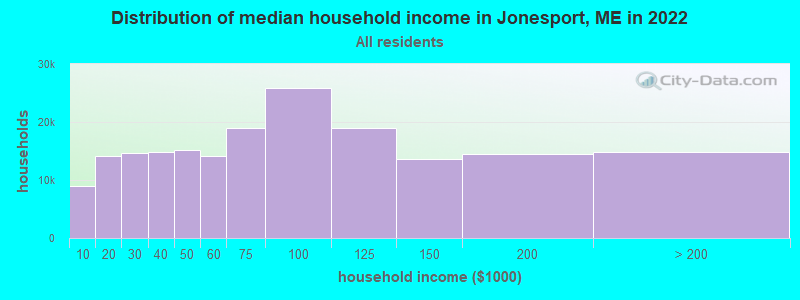
| Jonesport: | $47,264 |
| ME: | $69,543 |
Estimated per capita income in 2022: $31,904 (it was $14,135 in 2000)
Jonesport town income, earnings, and wages data
Estimated median house or condo value in 2022: $177,971 (it was $73,300 in 2000)
| Jonesport: | $177,971 |
| ME: | $290,600 |
Mean prices in 2022: all housing units: $208,896; detached houses: $229,377; townhouses or other attached units: $190,242; in 2-unit structures: $139,050; in 3-to-4-unit structures: $456,045; in 5-or-more-unit structures: $413,457; mobile homes: $94,515; occupied boats, rvs, vans, etc.: $45,679
Detailed information about poverty and poor residents in Jonesport, ME


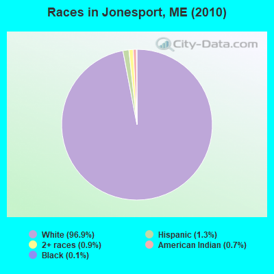
- 1,32796.9%White alone
- 181.3%Hispanic
- 130.9%Two or more races
- 90.7%American Indian alone
- 20.1%Black alone
- 10.07%Asian alone
Races in Jonesport detailed stats: ancestries, foreign born residents, place of birth
According to our research of Maine and other state lists, there were 3 registered sex offenders living in Jonesport, Maine as of May 23, 2024.
The ratio of all residents to sex offenders in Jonesport is 457 to 1.
The ratio of registered sex offenders to all residents in this city is near the state average.
 Recent articles from our blog. Our writers, many of them Ph.D. graduates or candidates, create easy-to-read articles on a wide variety of topics.

 | The adventure of one's own tiny island (8 replies) |
| North of MDI (7 replies) |
| How would Maine treat a big new family? (30 replies) |
| Desire to Move and Retire in Maine (23 replies) |
| Summer home coastal communities (7 replies) |
| Services in Washington County (31 replies) |
Latest news from Jonesport, ME collected exclusively by city-data.com from local newspapers, TV, and radio stations
Jonesport, ME City Guides:
Ancestries: English (28.2%), United States (26.1%), Irish (13.0%), French (7.2%), Scottish (5.6%), German (4.5%).
Current Local Time: EST time zone
Incorporated on 02/03/1832
Elevation: 19 feet
Land area: 28.5 square miles.
Population density: 48 people per square mile (very low).
13 residents are foreign born
| This town: | 0.9% |
| Maine: | 2.9% |
| Jonesport town: | 1.2% ($884) |
| Maine: | 1.5% ($1,417) |
Nearest city with pop. 50,000+: Portland, ME  (147.1 miles , pop. 64,249).
Nearest city with pop. 200,000+: Boston, MA (234.4 miles , pop. 589,141).
Nearest city with pop. 1,000,000+: Bronx, NY (409.9 miles , pop. 1,332,650).
Nearest cities:
), Latitude: 44.55 N, Longitude: 67.58 W
Area code: 207

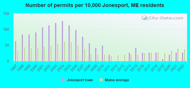
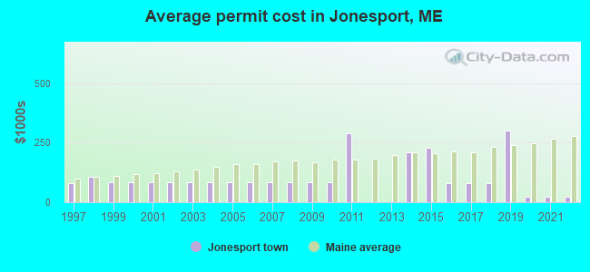
Single-family new house construction building permits:
- 2022: 4 buildings, average cost: $20,900
- 2021: 4 buildings, average cost: $20,900
- 2020: 3 buildings, average cost: $20,900
- 2019: 1 building, cost: $300,000
- 2018: 4 buildings, average cost: $78,900
- 2017: 4 buildings, average cost: $78,900
- 2016: 4 buildings, average cost: $78,900
- 2015: 6 buildings, average cost: $226,800
- 2014: 4 buildings, average cost: $211,200
- 2011: 3 buildings, average cost: $289,000
- 2010: 7 buildings, average cost: $83,300
- 2009: 6 buildings, average cost: $83,300
- 2008: 8 buildings, average cost: $83,300
- 2007: 11 buildings, average cost: $83,300
- 2006: 14 buildings, average cost: $83,300
- 2005: 16 buildings, average cost: $83,300
- 2004: 18 buildings, average cost: $83,300
- 2003: 17 buildings, average cost: $83,300
- 2002: 16 buildings, average cost: $83,300
- 2001: 15 buildings, average cost: $83,300
- 2000: 13 buildings, average cost: $83,300
- 1999: 12 buildings, average cost: $83,300
- 1998: 12 buildings, average cost: $108,300
- 1997: 9 buildings, average cost: $80,000
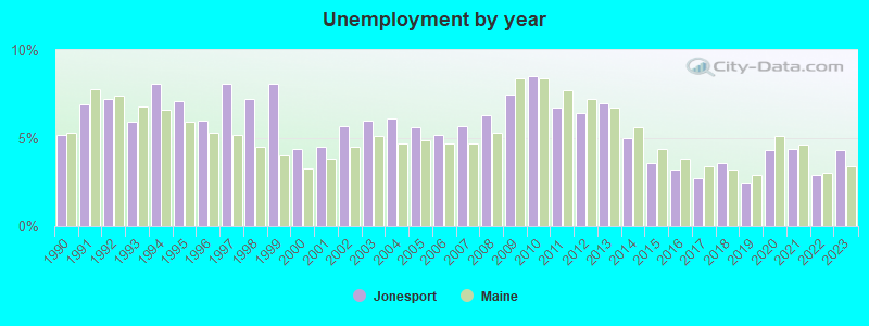
| Here: | 4.3% |
| Maine: | 3.4% |
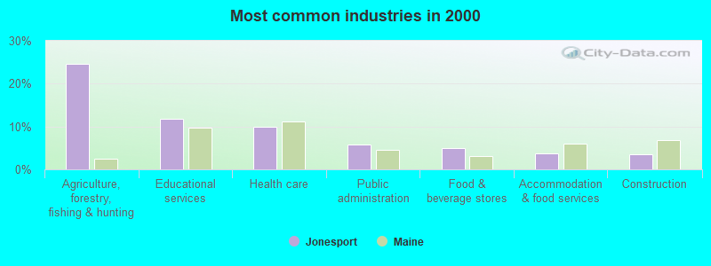
- Agriculture, forestry, fishing & hunting (24.7%)
- Educational services (11.8%)
- Health care (9.9%)
- Public administration (5.7%)
- Food & beverage stores (5.0%)
- Accommodation & food services (3.7%)
- Construction (3.5%)

- Agriculture, forestry, fishing & hunting (39.8%)
- Construction (6.2%)
- Repair & maintenance (5.6%)
- Educational services (4.3%)
- Food & beverage stores (3.9%)
- Groceries & related products merchant wholesalers (3.3%)
- Public administration (3.0%)

- Educational services (21.3%)
- Health care (20.5%)
- Public administration (9.2%)
- Food & beverage stores (6.3%)
- Accommodation & food services (5.9%)
- Agriculture, forestry, fishing & hunting (5.4%)
- Social assistance (4.6%)

- Fishing, hunting, and forestry occupations (19.7%)
- Preschool, kindergarten, elementary, and middle school teachers (4.8%)
- Other production occupations, including supervisors (4.2%)
- Cooks and food preparation workers (4.1%)
- Other sales and related occupations, including supervisors (3.5%)
- Cashiers (3.3%)
- Nursing, psychiatric, and home health aides (3.1%)

- Fishing, hunting, and forestry occupations (32.9%)
- Other sales and related occupations, including supervisors (6.2%)
- Rail and water transportation workers (4.6%)
- Other production occupations, including supervisors (4.3%)
- Driver/sales workers and truck drivers (4.3%)
- Electrical equipment mechanics and other installation, maintenance, and repair workers, including supervisors (3.6%)
- Laborers and material movers, hand (3.6%)

- Preschool, kindergarten, elementary, and middle school teachers (9.6%)
- Cooks and food preparation workers (8.4%)
- Cashiers (7.5%)
- Nursing, psychiatric, and home health aides (7.1%)
- Registered nurses (5.9%)
- Secretaries and administrative assistants (5.4%)
- Other management occupations, except farmers and farm managers (4.6%)
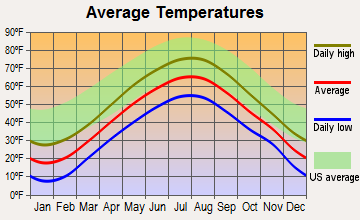
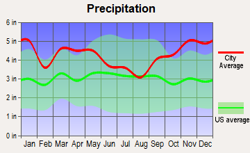
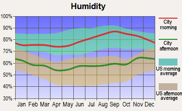
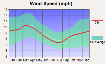
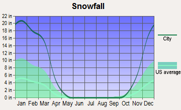
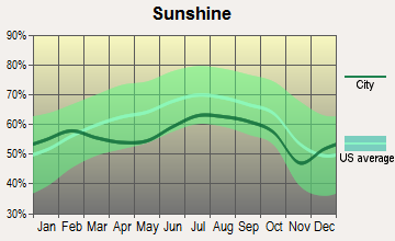
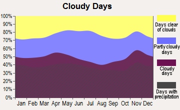
Average climate in Jonesport, Maine
Based on data reported by over 4,000 weather stations
(lower is better)
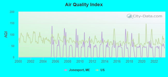
Air Quality Index (AQI) level in 2023 was 50.1. This is significantly better than average.
| City: | 50.1 |
| U.S.: | 72.6 |
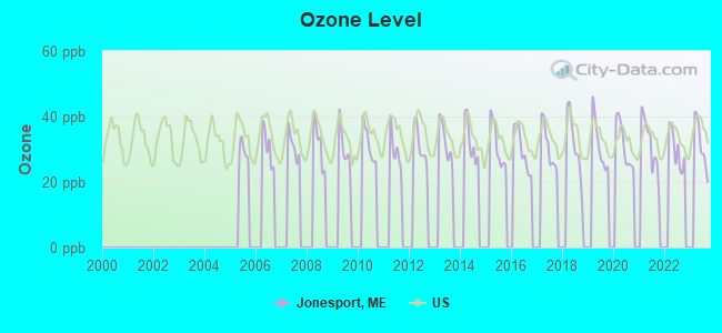
Ozone [ppb] level in 2023 was 31.5. This is about average. Closest monitor was 1.8 miles away from the city center.
| City: | 31.5 |
| U.S.: | 33.3 |
Earthquake activity:
Jonesport-area historical earthquake activity is significantly above Maine state average. It is 83% smaller than the overall U.S. average.On 10/16/2012 at 23:12:25, a magnitude 4.7 (4.7 ML, Depth: 10.0 mi, Class: Light, Intensity: IV - V) earthquake occurred 166.6 miles away from the city center
On 4/20/2002 at 10:50:47, a magnitude 5.3 (5.3 ML, Depth: 3.0 mi, Class: Moderate, Intensity: VI - VII) earthquake occurred 301.7 miles away from the city center
On 4/20/2002 at 10:50:47, a magnitude 5.2 (5.2 MB, 4.2 MS, 5.2 MW, 5.0 MW) earthquake occurred 302.8 miles away from Jonesport center
On 1/19/1982 at 00:14:42, a magnitude 4.7 (4.5 MB, 4.7 MD, 4.5 LG) earthquake occurred 212.9 miles away from the city center
On 10/7/1983 at 10:18:46, a magnitude 5.3 (5.1 MB, 5.3 LG, 5.1 ML) earthquake occurred 337.6 miles away from Jonesport center
On 10/3/2006 at 00:07:38, a magnitude 3.7 (3.7 MD, Depth: 6.2 mi, Class: Light, Intensity: II - III) earthquake occurred 30.9 miles away from Jonesport center
Magnitude types: regional Lg-wave magnitude (LG), body-wave magnitude (MB), duration magnitude (MD), local magnitude (ML), surface-wave magnitude (MS), moment magnitude (MW)
Natural disasters:
The number of natural disasters in Washington County (20) is greater than the US average (15).Major Disasters (Presidential) Declared: 14
Emergencies Declared: 6
Causes of natural disasters: Floods: 11, Storms: 10, Snows: 5, Winds: 2, Winter Storms: 2, Blizzard: 1, Heavy Rain: 1, Hurricane: 1, Ice Storm: 1, Landslide: 1, Snowfall: 1, Other: 2 (Note: some incidents may be assigned to more than one category).
Hospitals and medical centers in Jonesport:
Colleges/universities with over 2000 students nearest to Jonesport:
- University of Maine (about 59 miles; Orono, ME; Full-time enrollment: 8,931)
- Husson University (about 63 miles; Bangor, ME; FT enrollment: 2,421)
- University of Maine at Augusta (about 111 miles; Augusta, ME; FT enrollment: 3,204)
- University of Maine at Farmington (about 127 miles; Farmington, ME; FT enrollment: 2,036)
- Southern Maine Community College (about 146 miles; South Portland, ME; FT enrollment: 4,666)
- University of Southern Maine (about 148 miles; Portland, ME; FT enrollment: 6,647)
- Saint Joseph's College of Maine (about 153 miles; Standish, ME; FT enrollment: 2,010)
Public high school in Jonesport:
- JONESPORT-BEALS HIGH SCHOOL (Location: 180 SNARE CREEK LANE, Grades: 9-12)
Public elementary/middle school in Jonesport:
- JONESPORT ELEMENTARY SCHOOL (Location: 139 SNARE CREEK LANE, Grades: PK-8)
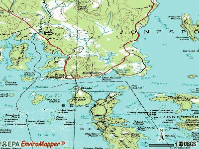
Points of interest:
Notable locations in Jonesport: Mason Bay (A), Jonesport Volunteer Fire Department (B), Jonesport Volunteer Fire Department - Mason Bay Substation (C), Moosabec Ambulance Service (D). Display/hide their locations on the map
Cemetery: Greenwood Cemetery (1). Display/hide its location on the map
Reservoir: Snare Creek (A). Display/hide its location on the map
Creeks: Southwest Creek (A), Snare Creek (B), Mansfield Creek (C). Display/hide their locations on the map
Beach: Little Pond Beach (A). Display/hide its location on the map
Birthplace of: Dana Sawyer - Writer, Marv Peasley - Baseball player.
Drinking water stations with addresses in Jonesport and their reported violations in the past:
MSU 103 JONESPORT ELEM/JBHS (Population served: 232, Groundwater):Past monitoring violations:MSU 103 BEALS ELEM SCHOOL (Population served: 53, Groundwater):
- 3 routine major monitoring violations
- 34 regular monitoring violations
Past monitoring violations:ARNOLD MEMORIAL MEDICAL BLDG (Population served: 51, Groundwater):
- Follow-up Or Routine LCR Tap M/R - In JAN-01-2007, Contaminant: Lead and Copper Rule. Follow-up actions: St Public Notif requested (FEB-20-2007), St Violation/Reminder Notice (FEB-20-2007), St Public Notif received (MAR-01-2007), St Compliance achieved (AUG-29-2011)
- Water Quality Parameter M/R - Between JUL-2006 and DEC-2006, Contaminant: Lead and Copper Rule. Follow-up actions: St Public Notif requested (FEB-07-2007), St Violation/Reminder Notice (FEB-07-2007), St Public Notif received (FEB-27-2007), St Compliance achieved (AUG-29-2011)
- One routine major monitoring violation
Past health violations:SUNRISE CARE FACILITY (Population served: 26, Groundwater):Past monitoring violations:
- MCL, Monthly (TCR) - In DEC-2011, Contaminant: Coliform. Follow-up actions: St Public Notif requested (DEC-23-2011), St Formal NOV issued (DEC-23-2011), St Public Notif received (JUL-03-2012)
- 5 routine major monitoring violations
Past monitoring violations:US CG JONESPORT - STATION (Population served: 25, Groundwater under infl of surface water):
- Monitoring and Reporting (DBP) - Between JAN-2011 and DEC-2013, Contaminant: Total Haloacetic Acids (HAA5). Follow-up actions: St Public Notif requested (NOV-25-2013), St Formal NOV issued (NOV-25-2013), St Public Notif received (DEC-26-2013)
- Monitoring and Reporting (DBP) - Between JAN-2011 and DEC-2013, Contaminant: TTHM. Follow-up actions: St Public Notif requested (NOV-25-2013), St Formal NOV issued (NOV-25-2013), St Public Notif received (DEC-26-2013)
Past health violations:Past monitoring violations:
- Treatment Technique (SWTR and GWR) - In DEC-2011. Follow-up actions: St Public Notif requested (FEB-07-2012), St Formal NOV issued (FEB-07-2012), St Public Notif received (MAY-21-2012), St Compliance achieved (JUL-26-2012)
- Treatment Technique (SWTR and GWR) - In NOV-2011. Follow-up actions: St Public Notif requested (FEB-07-2012), St Formal NOV issued (FEB-07-2012), St Public Notif received (MAY-21-2012), St Compliance achieved (JUL-26-2012)
- 2 routine major monitoring violations
| This town: | 2.2 people |
| Maine: | 2.3 people |
| This town: | 64.1% |
| Whole state: | 62.9% |
| This town: | 9.5% |
| Whole state: | 9.4% |
Likely homosexual households (counted as self-reported same-sex unmarried-partner households)
- Lesbian couples: 0.3% of all households
- Gay men: 0.5% of all households
| This town: | 19.8% |
| Whole state: | 10.9% |
| This town: | 6.1% |
| Whole state: | 4.1% |
4 people in military barracks and dormitories (nondisciplinary) in 2010
People in group quarters in Jonesport in 2000:
- 28 people in nursing homes
- 7 people in military barracks, etc.
- 2 people in homes for the mentally retarded
Banks with branches in Jonesport (2011 data):
- Bangor Savings Bank: Jonesport Branch at 175 Main Street, branch established on 1933/11/20. Info updated 2008/12/02: Bank assets: $2,556.3 mil, Deposits: $1,940.3 mil, headquarters in Bangor, ME, positive income, Commercial Lending Specialization, 58 total offices, Holding Company: Bangor Bancorp, Mhc
- The Camden National Bank: Jonesport Branch at 51 Main Street, branch established on 1974/06/10. Info updated 2008/02/27: Bank assets: $2,266.8 mil, Deposits: $1,604.6 mil, headquarters in Camden, ME, positive income, Commercial Lending Specialization, 39 total offices, Holding Company: Camden National Corporation
For population 15 years and over in Jonesport:
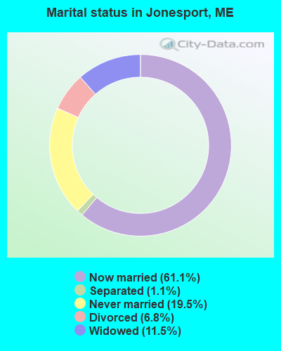
- Never married: 19.5%
- Now married: 61.1%
- Separated: 1.1%
- Widowed: 11.5%
- Divorced: 6.8%
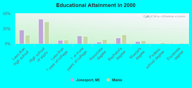
For population 25 years and over in Jonesport:
- High school or higher: 77.4%
- Bachelor's degree or higher: 14.6%
- Graduate or professional degree: 4.9%
- Unemployed: 6.9%
- Mean travel time to work (commute): 17.8 minutes

| Here: | 11.5 |
| Maine average: | 11.2 |
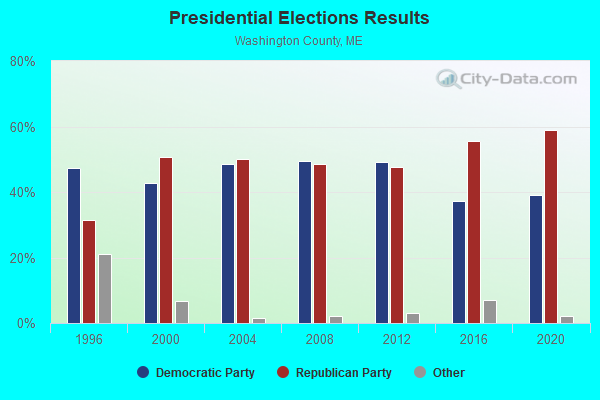

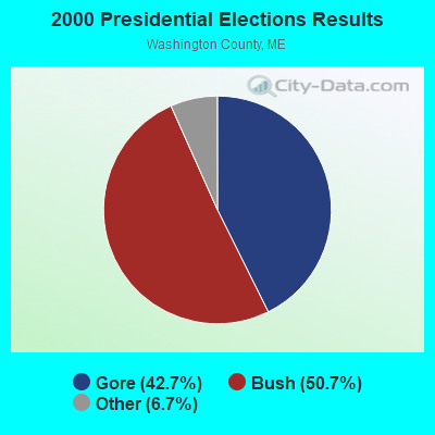


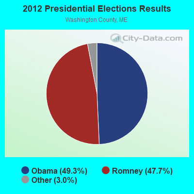


Graphs represent county-level data. Detailed 2008 Election Results
Religion statistics for Jonesport, ME (based on Washington County data)
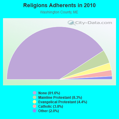
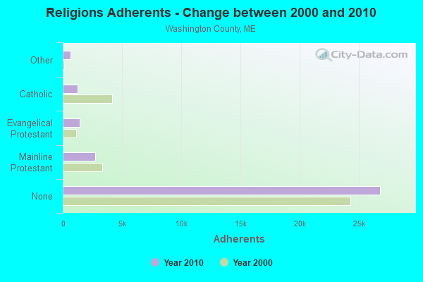
| Religion | Adherents | Congregations |
|---|---|---|
| Mainline Protestant | 2,731 | 37 |
| Evangelical Protestant | 1,442 | 31 |
| Catholic | 1,238 | 10 |
| Other | 648 | 13 |
| None | 26,797 | - |
Food Environment Statistics:
| Washington County: | 4.89 / 10,000 pop. |
| Maine: | 2.80 / 10,000 pop. |
| Washington County: | 1.22 / 10,000 pop. |
| Maine: | 2.20 / 10,000 pop. |
| This county: | 9.78 / 10,000 pop. |
| State: | 5.75 / 10,000 pop. |
| Washington County: | 11.31 / 10,000 pop. |
| Maine: | 11.02 / 10,000 pop. |
| Washington County: | 9.4% |
| Maine: | 8.2% |
| Here: | 28.3% |
| Maine: | 25.0% |
Businesses in Jonesport, ME
- True Value: 1
Strongest AM radio stations in Jonesport:
- WZON (620 AM; 5 kW; BANGOR, ME; Owner: THE ZONE CORPORATION)
- WDEA (1370 AM; 5 kW; ELLSWORTH, ME; Owner: CUMULUS LICENSING CORP.)
- WABI (910 AM; 5 kW; BANGOR, ME; Owner: CLEAR CHANNEL BROADCASTING LICENSES, INC.)
- WRKO (680 AM; 50 kW; BOSTON, MA; Owner: ENTERCOM BOSTON LICENSE, LLC)
- WEEI (850 AM; 50 kW; BOSTON, MA; Owner: ENTERCOM BOSTON LICENSE, LLC)
- WBZ (1030 AM; 50 kW; BOSTON, MA; Owner: INFINITY BROADCASTING OPERATIONS, INC.)
- WCRN (830 AM; 50 kW; WORCESTER, MA; Owner: CARTER BROADCASTING CORPORATION)
- WSKW (1160 AM; 10 kW; SKOWHEGAN, ME; Owner: MOUNTAIN WIRELESS, INCORPORATED)
- WNNZ (640 AM; 50 kW; WESTFIELD, MA; Owner: CLEAR CHANNEL BROADCASTING LICENSES, INC.)
- WALE (990 AM; 50 kW; GREENVILLE, RI; Owner: NORTH AMERICAN BROADCASTING CO., INC.)
- WKOX (1200 AM; 50 kW; FRAMINGHAM, MA; Owner: CAPSTAR TX LIMITED PARTNERSHIP)
- WWZN (1510 AM; 50 kW; BOSTON, MA; Owner: ROSE CITY RADIO CORPORATION)
- WBIX (1060 AM; 40 kW; NATICK, MA; Owner: LANGER BROADCASTING CORPORATION)
Strongest FM radio stations in Jonesport:
- WNSX (97.7 FM; WINTER HARBOR, ME; Owner: CLEAR CHANNEL BROADCASTING LICENSES, INC.)
- WHCF (88.5 FM; BANGOR, ME; Owner: BANGOR BAPTIST CHURCH)
- WALZ-FM (95.3 FM; MACHIAS, ME; Owner: WILLIAM MCVICAR & ROGER HOLST, GEN. PARTNERSHIP)
- WBQI (107.7 FM; BAR HARBOR, ME; Owner: MARINER BROADCASTING, L.P.)
- Jonesport, Maine
- Fatal accident count12
- Vehicles involved in fatal accidents13
- Fatal accidents involving drunk persons:6
- Fatalities14
- Persons involved in fatal accidents18
- Pedestrians involved in fatal accidents1
- Maine average
- Fatal accident count1683
- Vehicles involved in fatal accidents2338
- Fatal accidents involving drunk persons731
- Fatalities1847
- Persons involved in fatal accidents3847
- Pedestrians involved in fatal accidents131
- National Bridge Inventory (NBI) Statistics
- 1Number of bridges
- 7ft / 1.8mTotal length
- 2,861Total average daily traffic
- 143Total average daily truck traffic
- 4,005Total future (year 2036) average daily traffic
FCC Registered Antenna Towers:
5- Mark L Gartley, Feeney Street (Lat: 44.539778 Lon: -67.603028), Type: 77.7, Overall height: 76.2 m, Registrant: Holland & Knight LLP, Pconnolly@hklaw.Com, , Washi-ngton, Phone: (202) 862-5989
- Mark L Gartley, Feeney Street (Lat: 44.539778 Lon: -67.603028), Type: 77.7, Overall height: 76.2 m, Registrant: Holland & Knight LLP, Pconnolly@hklaw.Com, , Washi-ngton, Phone: (202) 862-5989
- Cayla Gamble, Feeney Street (Lat: 44.539778 Lon: -67.603028), Type: 77.7, Structure height: 23029 m, Overall height: 76.2 m, Registrant: Holland & Knight LLP, Peter.Connolly@hklaw.Com, , Washi-ngton, Phone: (202) 862-5989
- Cayla Gamble, Feeney Street (Lat: 44.539778 Lon: -67.603028), Type: 77.7, Structure height: 23029 m, Overall height: 76.2 m, Registrant: Holland & Knight LLP, Peter.Connolly@hklaw.Com, , Washi-ngton, Phone: (202) 862-5989
- Cayla Gamble, Feeney Street (Lat: 44.539778 Lon: -67.603028), Type: 77.7, Structure height: 23029 m, Overall height: 76.2 m, Registrant: Wilkinson Barker Knauer, LLP, Gwerner@wbklaw.Com, , Washi-ngton, Phone: (202) 383-3420
FCC Registered Broadcast Land Mobile Towers:
1- Roque Island (Lat: 44.591750 Lon: -67.541111), Call Sign: KNEZ282,
Assigned Frequencies: 461.500 MHz, Grant Date: 02/24/1998, Expiration Date: 05/03/2003, Cancellation Date: 08/03/2003, Registrant: Roque Island Gardner Homestead Corporation, Rfd 1 Box 213, Machias, ME 04654
FCC Registered Maritime Coast & Aviation Ground Towers:
2- 52 Loon Point Rd (Lat: 44.541750 Lon: -67.566111), Type: Building, Overall height: 6 m, Call Sign: KYY295,
Assigned Frequencies: 156.425 MHz, 156.800 MHz, 156.450 MHz, Grant Date: 05/29/1996, Expiration Date: 05/29/2001, Cancellation Date: 09/02/2001, Registrant: John W Beal Jr, 52 Loon Point Rd, Jonesport, ME 04649
- Rr2 Box 920 Main St (Lat: 44.533417 Lon: -67.616111), Type: Building, Overall height: 4 m, Call Sign: WHX583,
Assigned Frequencies: 156.450 MHz, 156.800 MHz, 156.900 MHz, Grant Date: 04/06/2004, Expiration Date: 05/25/2014, Cancellation Date: 07/26/2014, Registrant: Universal Licensing Service, 3419 Via Lido Suite 609, Newport Beach, CA 92663-3908, Phone: (877) 677-3639, Fax: (949) 723-2025
FCC Registered Amateur Radio Licenses:
5- Call Sign: KB3CUE, Licensee ID: L00209617, Grant Date: 05/04/2018, Expiration Date: 06/25/2028, Certifier: Andrew J Phillips, Registrant: Andrew J Phillips, 4 Arks Street, Jonesport, ME 04649
- Call Sign: N1AMG, Grant Date: 07/29/1994, Expiration Date: 07/29/2004, Cancellation Date: 08/01/2006, Registrant: William R Torrey Jr, Cove St Rr 01 Box 1140, Jonesport, ME 04649
- Call Sign: N1VLN, Licensee ID: L01062813, Grant Date: 09/13/2005, Expiration Date: 06/27/2015, Cancellation Date: 06/28/2017, Certifier: Harold S Floyd, Registrant: Harold S Floyd, Island St, Jonesport, ME 04649
- Call Sign: NC1Q, Licensee ID: L01167263, Grant Date: 08/18/2016, Expiration Date: 09/17/2026, Certifier: Timothy W Anderson, Registrant: Timothy W Anderson, 61 Main St, Jonesport, ME 04649-3303
- Call Sign: W1PCY, Licensee ID: L00764427, Grant Date: 11/08/2003, Expiration Date: 11/08/2013, Cancellation Date: 09/27/2013, Registrant: Albert E Wilder, Rr 1 Box 730, Jonesport, ME 04649
FAA Registered Aircraft:
2- Aircraft: PIPER PA-28-161 (Category: Land, Seats: 4, Weight: Up to 12,499 Pounds, Speed: 108 mph), Engine: LYCOMING 0-320 SERIES (180 HP) (Reciprocating)
N-Number: 3858M, N3858M, N-3858M, Serial Number: 28-7816628, Year manufactured: 1978, Airworthiness Date: 05/26/1978, Certificate Issue Date: 02/14/2014
Registrant (Corporation): Machias Auto Parts Inc, 34 Englishman Bay Rd, Jonesport, ME 04649 - Aircraft: CARLTON BRIAN BB 52-8 (Category: Land, Weight: Up to 12,499 Pounds), Engine: None
N-Number: 697BC, N697BC, N-697BC, Serial Number: 001, Year manufactured: 1996, Airworthiness Date: 07/22/1997, Certificate Issue Date: 10/21/1996
Registrant (Individual): Brian F Carlton, 1150 Mason Bay Rd, Jonesport, ME 04649
Deregistered: Cancel Date: 07/21/2017
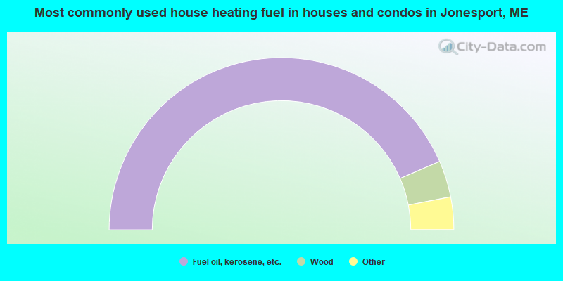
- 87.0%Fuel oil, kerosene, etc.
- 6.9%Wood
- 3.5%Bottled, tank, or LP gas
- 2.2%Electricity
- 0.4%Utility gas
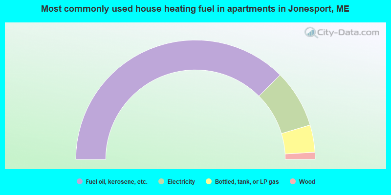
- 75.0%Fuel oil, kerosene, etc.
- 15.7%Electricity
- 7.4%Bottled, tank, or LP gas
- 1.9%Wood
Jonesport compared to Maine state average:
- Median house value below state average.
- Unemployed percentage below state average.
- Black race population percentage significantly below state average.
- Median age above state average.
- Foreign-born population percentage significantly below state average.
- Renting percentage below state average.
- Length of stay since moving in significantly above state average.
- Number of rooms per house significantly below state average.
- House age significantly below state average.
- Institutionalized population percentage above state average.
- Percentage of population with a bachelor's degree or higher below state average.

|
Total of 2 patent applications in 2008-2024.