Huntley Project, Montana
Submit your own pictures of this place and show them to the world
- OSM Map
- General Map
- Google Map
- MSN Map

| Males: 1,895 | |
| Females: 1,813 |
| Median resident age: | 39.2 years |
| Montana median age: | 37.5 years |
Zip code: 59064
| Huntley Project: | $74,273 |
| MT: | $67,631 |
Estimated per capita income in 2022: $35,370 (it was $17,413 in 2000)
Huntley Project CCD income, earnings, and wages data
Estimated median house or condo value in 2022: $290,301 (it was $85,300 in 2000)
| Huntley Project: | $290,301 |
| MT: | $366,400 |
Mean prices in 2022: all housing units: $412,360; detached houses: $455,211; townhouses or other attached units: $375,731; in 2-unit structures: $194,794; in 3-to-4-unit structures: $175,861; in 5-or-more-unit structures: $226,631; mobile homes: $99,717; occupied boats, rvs, vans, etc.: $41,773
Huntley Project, MT residents, houses, and apartments details
Detailed information about poverty and poor residents in Huntley Project, MT


- 3,19693.2%White alone
- 1534.5%Hispanic
- 421.2%Two or more races
- 220.6%American Indian alone
- 80.2%Other race alone
- 50.1%Black alone
- 40.1%Asian alone

Races in Huntley Project detailed stats: ancestries, foreign born residents, place of birth
 Recent articles from our blog. Our writers, many of them Ph.D. graduates or candidates, create easy-to-read articles on a wide variety of topics.
Current Local Time: MST time zone
Land area: 340.3 square miles.
Population density: 11 people per square mile (very low).

| Huntley Project CCD: | 1.0% ($853) |
| Montana: | 1.3% ($1,212) |
Nearest city with pop. 50,000+: Billings, MT  (30.3 miles , pop. 89,847).
Nearest city with pop. 200,000+: West Adams, CO (448.6 miles , pop. 259,628).
Nearest city with pop. 1,000,000+: Phoenix, AZ (888.3 miles , pop. 1,321,045).
Nearest cities:
), ), )Latitude: 45.98 N, Longitude: 107.97 W
Area code commonly used in this area: 406


| Here: | 3.5% |
| Montana: | 3.8% |

- Agriculture, forestry, fishing & hunting (14.5%)
- Educational services (7.5%)
- Health care (7.1%)
- Construction (6.6%)
- Accommodation & food services (4.8%)
- Public administration (4.3%)
- Truck transportation (4.1%)

- Agriculture, forestry, fishing & hunting (17.0%)
- Construction (11.1%)
- Truck transportation (6.6%)
- Public administration (4.9%)
- Petroleum & coal products (4.3%)
- Repair & maintenance (3.7%)
- Building material & garden equipment & supplies dealers (3.1%)

- Health care (13.0%)
- Educational services (12.6%)
- Agriculture, forestry, fishing & hunting (11.6%)
- Accommodation & food services (7.3%)
- Social assistance (4.7%)
- Building material & garden equipment & supplies dealers (4.7%)
- Finance & insurance (4.2%)

- Farmers and farm managers (7.7%)
- Building and grounds cleaning and maintenance occupations (4.6%)
- Material recording, scheduling, dispatching, and distributing workers (4.1%)
- Agricultural workers, including supervisors (4.0%)
- Driver/sales workers and truck drivers (3.9%)
- Vehicle and mobile equipment mechanics, installers, and repairers (3.8%)
- Bookkeeping, accounting, and auditing clerks (3.6%)

- Farmers and farm managers (9.0%)
- Vehicle and mobile equipment mechanics, installers, and repairers (7.2%)
- Driver/sales workers and truck drivers (6.6%)
- Agricultural workers, including supervisors (5.5%)
- Other sales and related occupations, including supervisors (4.3%)
- Other production occupations, including supervisors (4.1%)
- Material recording, scheduling, dispatching, and distributing workers (4.0%)

- Bookkeeping, accounting, and auditing clerks (7.3%)
- Secretaries and administrative assistants (6.5%)
- Farmers and farm managers (6.1%)
- Building and grounds cleaning and maintenance occupations (5.3%)
- Preschool, kindergarten, elementary, and middle school teachers (4.7%)
- Cashiers (4.6%)
- Material recording, scheduling, dispatching, and distributing workers (4.3%)
Average climate in Huntley Project, Montana
Based on data reported by over 4,000 weather stations


(lower is better)

Air Quality Index (AQI) level in 2022 was 65.9. This is about average.
| City: | 65.9 |
| U.S.: | 72.6 |

Sulfur Dioxide (SO2) [ppb] level in 2008 was 3.12. This is significantly worse than average. Closest monitor was 22.0 miles away from the city center.
| City: | 3.12 |
| U.S.: | 1.51 |

Particulate Matter (PM2.5) [µg/m3] level in 2022 was 6.85. This is about average. Closest monitor was 24.9 miles away from the city center.
| City: | 6.85 |
| U.S.: | 8.11 |
Earthquake activity:
Huntley Project-area historical earthquake activity is significantly above Montana state average. It is 568% greater than the overall U.S. average.On 8/18/1959 at 06:37:13, a magnitude 7.7 (7.7 UK, Class: Major, Intensity: VIII - XII) earthquake occurred 163.2 miles away from the city center, causing $26,000,000 total damage
On 10/28/1983 at 14:06:06, a magnitude 7.3 (6.2 MB, 7.3 MS, 7.0 MW) earthquake occurred 313.8 miles away from the city center, causing 2 deaths (2 shaking deaths) and 3 injuries, causing $15,000,000 total damage
On 6/30/1975 at 18:54:13, a magnitude 6.1 (5.6 MB, 5.9 MS, 6.1 UK, 6.1 ML, Class: Strong, Intensity: VII - IX) earthquake occurred 162.0 miles away from Huntley Project center
On 3/31/2020 at 23:52:30, a magnitude 6.5 (6.5 MW, Depth: 7.5 mi) earthquake occurred 363.3 miles away from the city center
On 7/6/2017 at 06:30:17, a magnitude 5.8 (5.8 MW, Depth: 7.6 mi, Class: Moderate, Intensity: VI - VII) earthquake occurred 227.9 miles away from Huntley Project center
On 7/26/2005 at 04:08:37, a magnitude 5.7 (5.7 MB, 5.2 MS, 5.6 MW) earthquake occurred 225.9 miles away from Huntley Project center
Magnitude types: body-wave magnitude (MB), local magnitude (ML), surface-wave magnitude (MS), moment magnitude (MW)
Natural disasters:
The number of natural disasters in Yellowstone County (9) is smaller than the US average (15).Major Disasters (Presidential) Declared: 4
Emergencies Declared: 1
Causes of natural disasters: Fires: 4, Floods: 3, Storms: 3, Hurricane: 1, Snow: 1, Other: 1 (Note: some incidents may be assigned to more than one category).
Colleges/universities with over 2000 students nearest to Huntley Project:
- Montana State University-Billings (about 30 miles; Billings, MT; Full-time enrollment: 4,319)
- Sheridan College (about 99 miles; Sheridan, WY; FT enrollment: 2,070)
- Montana State University (about 150 miles; Bozeman, MT; FT enrollment: 12,942)
- Black Hills State University (about 225 miles; Spearfish, SD; FT enrollment: 3,166)
- Casper College (about 233 miles; Casper, WY; FT enrollment: 2,770)
- Brigham Young University-Idaho (about 240 miles; Rexburg, ID; FT enrollment: 30,522)
- South Dakota School of Mines and Technology (about 268 miles; Rapid City, SD; FT enrollment: 2,102)
Points of interest:
Notable locations in Huntley Project: Gritty Stone Fishing Access Site (A), Voyagers Rest Fishing Access Site (B), Captain Clark Fishing Access Site (C), Manuel Lisa Fishing Access Site (D), Pompeys Pillar Fishing Access Site (E), Worden Volunteer Fire Department Station 2 Huntley (F), Worden Volunteer Fire Department Station 3 Pompeys Pillar (G), Worden Volunteer Fire Department Station 1 Headquarters (H), Custer Volunteer Fire Department (I). Display/hide their locations on the map
Cemetery: Huntley Cemetery (1). Display/hide its location on the map
Reservoir: Anita Reservoir (A). Display/hide its location on the map
Streams, rivers, and creeks: Bighorn River (A), Automatic Creek (B), Custer Coulee (C), Deer Creek (D), Fly Creek (E), Kaiser Creek (F), Lost Boy Creek (G), Mill Creek (H), Rock Creek (I). Display/hide their locations on the map
Park in Huntley Project: Pompeys Pillar National Historic Landmark (1). Display/hide its location on the map
| This place: | 2.4 people |
| Montana: | 2.4 people |
| This place: | 70.4% |
| Whole state: | 62.8% |
| This place: | 4.7% |
| Whole state: | 6.7% |
Likely homosexual households (counted as self-reported same-sex unmarried-partner households)
- Lesbian couples: 0.3% of all households
- Gay men: 0.0% of all households
| This place: | 12.6% |
| Whole state: | 14.6% |
| This place: | 4.1% |
| Whole state: | 5.8% |
For population 15 years and over in Huntley Project:

- Never married: 19.0%
- Now married: 62.7%
- Separated: 1.5%
- Widowed: 7.3%
- Divorced: 11.0%
For population 25 years and over in Huntley Project:
- High school or higher: 85.3%
- Bachelor's degree or higher: 12.9%
- Graduate or professional degree: 1.4%
- Unemployed: 6.3%
- Mean travel time to work (commute): 24.1 minutes


| Here: | 9.4 |
| Montana average: | 10.4 |
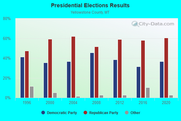
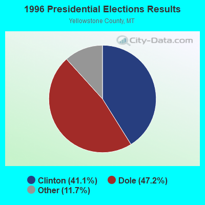

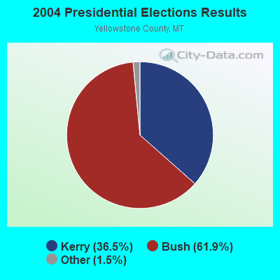
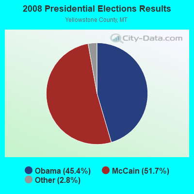
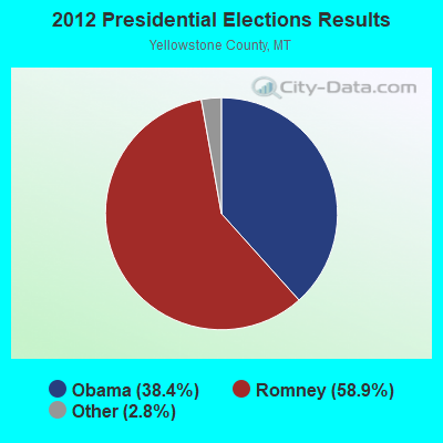
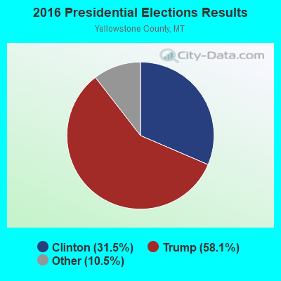
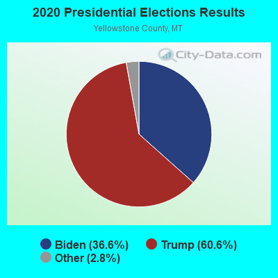
Graphs represent county-level data. Detailed 2008 Election Results
Religion statistics for Huntley Project, MT (based on Yellowstone County data)
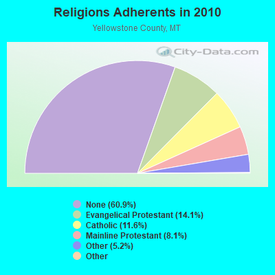
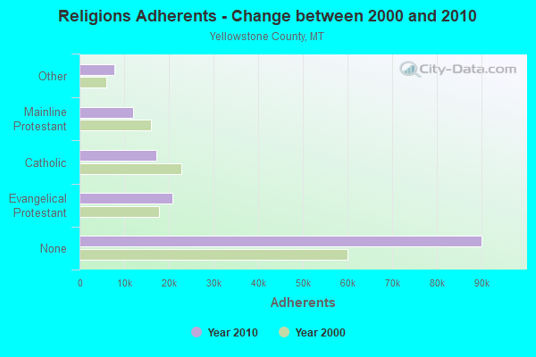
| Religion | Adherents | Congregations |
|---|---|---|
| Evangelical Protestant | 20,845 | 86 |
| Catholic | 17,155 | 12 |
| Mainline Protestant | 11,920 | 35 |
| Other | 7,761 | 29 |
| Black Protestant | 123 | 1 |
| Orthodox | 100 | 1 |
| None | 90,068 | - |
Food Environment Statistics:
| Here: | 1.14 / 10,000 pop. |
| State: | 2.55 / 10,000 pop. |
| This county: | 0.21 / 10,000 pop. |
| Montana: | 0.20 / 10,000 pop. |
| Yellowstone County: | 0.21 / 10,000 pop. |
| State: | 0.48 / 10,000 pop. |
| Yellowstone County: | 4.72 / 10,000 pop. |
| Montana: | 4.69 / 10,000 pop. |
| Yellowstone County: | 7.30 / 10,000 pop. |
| Montana: | 10.38 / 10,000 pop. |
| Here: | 7.3% |
| State: | 7.2% |
| This county: | 25.7% |
| Montana: | 23.1% |
| This county: | 10.6% |
| Montana: | 10.7% |
Strongest AM radio stations in Huntley Project:
- KURL (730 AM; 5 kW; BILLINGS, MT; Owner: ELENBAAS MEDIA, INC.)
- KBUL (970 AM; 5 kW; BILLINGS, MT; Owner: CAPSTAR TX LIMITED PARTNERSHIP)
- KGHL (790 AM; 5 kW; BILLINGS, MT; Owner: NEW NORTHWEST BROADCASTERS, LLC)
- KHDN (1230 AM; 1 kW; HARDIN, MT; Owner: SUN MOUNTAIN, INC.)
- KBLG (910 AM; 1 kW; BILLINGS, MT; Owner: FISHER RADIO REGIONAL GROUP, INC.)
- KATL (770 AM; 10 kW; MILES CITY, MT; Owner: STAR PRINTING COMPANY)
- KIKC (1250 AM; 5 kW; FORSYTH, MT; Owner: MILES CITY, FORSYTH B/DCSTG, INC.)
- KMZK (1240 AM; 1 kW; BILLINGS, MT; Owner: ELENBAAS MEDIA, INC.)
- KTWO (1030 AM; 50 kW; CASPER, WY; Owner: CITICASTERS LICENSES, L.P.)
- KMTA (1050 AM; 10 kW; MILES CITY, MT; Owner: SENGER BROADCASTING CORPORATION)
- KZMQ (1140 AM; daytime; 10 kW; GREYBULL, WY; Owner: LEGEND COMMUNICATIONS OF WYOMING LLC)
- KERR (750 AM; 50 kW; POLSON, MT; Owner: ANDERSON RADIO BROADCASTING, INC.)
- KGVW (640 AM; 10 kW; BELGRADE, MT; Owner: GALLATIN VALLEY WITNESS, INC.)
Strongest FM radio stations in Huntley Project:
- KRKX (94.1 FM; BILLINGS, MT; Owner: FISHER RADIO REGIONAL GROUP, INC.)
- KMHK (95.5 FM; HARDIN, MT; Owner: CAPSTAR TX LIMITED PARTNERSHIP)
- KZRV (107.5 FM; BILLINGS, MT; Owner: NEW NORTHWEST BROADCASTERS, LLC)
- K205CL (88.9 FM; SHEPHERD, MT; Owner: FAMILY STATIONS, INC.)
- KYYA-FM (93.3 FM; BILLINGS, MT; Owner: FISHER RADIO REGIONAL GROUP, INC.)
- KRZN (96.3 FM; BILLINGS, MT; Owner: FISHER RADIO REGIONAL GROUP, INC.)
- KLMT (89.3 FM; BILLINGS, MT; Owner: WESTERN INSPIRATIONAL BROADCASTERS INC)
- KCTR-FM (102.9 FM; BILLINGS, MT; Owner: CAPSTAR TX LIMITED PARTNERSHIP)
- KBBB (103.7 FM; BILLINGS, MT; Owner: CAPSTAR TX LIMITED PARTNERSHIP)
- KRSQ (101.9 FM; LAUREL, MT; Owner: NEW NORTHWEST BROADCASTERS, LLC)
- KKBR (97.1 FM; BILLINGS, MT; Owner: CAPSTAR TX LIMITED PARTNERSHIP)
TV broadcast stations around Huntley Project:
- KHMT (Channel 4; HARDIN, MT; Owner: VHR BROADCASTING OF BILLINGS, LLC)
- KSVI (Channel 6; BILLINGS, MT; Owner: QUORUM OF MONTANA LICENSE, LLC)
- KULR-TV (Channel 8; BILLINGS, MT; Owner: KULR CORPORATION)

- 41.3%Bottled, tank, or LP gas
- 23.7%Electricity
- 10.7%Fuel oil, kerosene, etc.
- 9.7%Wood
- 6.7%Coal or coke
- 3.0%Other fuel
- 2.4%No fuel used
- 2.1%Utility gas
- 0.4%Solar energy

- 30.0%Bottled, tank, or LP gas
- 26.1%Electricity
- 22.0%Fuel oil, kerosene, etc.
- 7.0%Utility gas
- 5.6%Coal or coke
- 4.9%Wood
- 4.5%Other fuel
Huntley Project compared to Montana state average:
- Unemployed percentage below state average.
- Foreign-born population percentage significantly below state average.
- Length of stay since moving in significantly above state average.
- Number of rooms per house significantly below state average.
- House age significantly below state average.
- Percentage of population with a bachelor's degree or higher below state average.