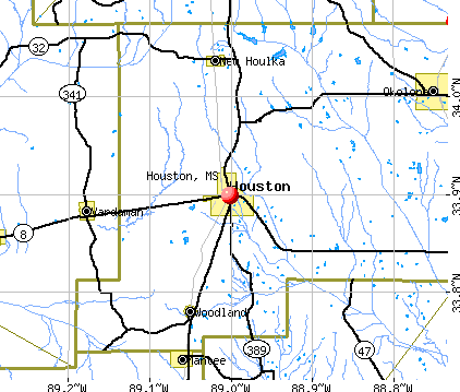
Houston, Mississippi
Submit your own pictures of this city and show them to the world
- OSM Map
- General Map
- Google Map
- MSN Map
Population change since 2000: -9.1%
 |
| Males: 1,584 | |
| Females: 2,125 |
| Median resident age: | 47.4 years |
| Mississippi median age: | 38.9 years |
Zip codes: 38851.
| Houston: | $32,247 |
| MS: | $52,719 |
Estimated per capita income in 2022: $20,533 (it was $12,482 in 2000)
Houston city income, earnings, and wages data
Estimated median house or condo value in 2022: $95,563 (it was $49,600 in 2000)
| Houston: | $95,563 |
| MS: | $162,500 |
Mean prices in 2022: all housing units: $120,995; detached houses: $124,877; mobile homes: $73,275
Median gross rent in 2022: $688.
(31.6% for White Non-Hispanic residents, 24.7% for Black residents, 56.0% for two or more races residents)
Detailed information about poverty and poor residents in Houston, MS

Compare current foreclosures in Houston, MS:
| Photo | Address | Area | Beds / Baths | Price | Details |
|---|---|---|---|---|---|

|
#1
County Road 271
Houston, MS 38851
|
1,331 sq. feet
|
- baths 3 beds |
show details | |

|
#2
County Road 20
Houston, MS 38851
|
1,373 sq. feet
|
- baths 4 beds |
show details | |

|
#3
County Road 254
Houston, MS 38851
|
1,215 sq. feet
|
- baths 3 beds |
show details | |

|
#4
Oak Lane Cir
Houston, MS 38851
|
1,000 sq. feet
|
- baths 3 beds |
show details | |

|
#5
E Madison St
Houston, MS 38851
|
1,462 sq. feet
|
- baths 3 beds |
show details | |

|
#6
Scott St
Houston, MS 38851
|
1,179 sq. feet
|
- baths 3 beds |
show details | |

|
#7
Okolona Cutoff Rd
Houston, MS 38851
|
1,148 sq. feet
|
- baths 3 beds |
show details | |

|
#8
E Hamilton St
Houston, MS 38851
|
2,288 sq. feet
|
- baths 2 beds |
show details | |

|
#9
Church St
Houston, MS 38851
|
1,104 sq. feet
|
- baths 3 beds |
show details | |

|
#10
N Pontotoc St
Houston, MS 38851
|
1,864 sq. feet
|
- baths 2 beds |
show details |
| Photo | Address | Area | Beds / Baths | Price | Details |
|---|---|---|---|---|---|

|
#11
Martin Dr
Houston, MS 38851
|
1,116 sq. feet
|
- baths 2 beds |
show details | |

|
#12
County Road 53
Houston, MS 38851
|
855 sq. feet
|
- baths 3 beds |
show details | |

|
#13
Gladney St
Houston, MS 38851
|
1,131 sq. feet
|
- baths 3 beds |
show details | |

|
#14
Jones Cir
Houston, MS 38851
|
1,161 sq. feet
|
- baths 3 beds |
show details | |

|
#15
Morris Cir
Houston, MS 38851
|
1,166 sq. feet
|
- baths 3 beds |
show details | |

|
#16
Chenault St
Houston, MS 38851
|
1,611 sq. feet
|
- baths 3 beds |
show details | |

|
#17
County Road 39
Houston, MS 38851
|
2,320 sq. feet
|
- baths - beds |
show details | |

|
#18
County Road 515 N
Houston, MS 38851
|
1,008 sq. feet
|
- baths - beds |
show details | |

|
#19
Highway 8 E
Houston, MS 38851
|
- sq. feet
|
- baths - beds |
show details | |

|
#20
County Road 418
Houston, MS 38851
|
- sq. feet
|
- baths - beds |
show details |
| Photo | Address | Area | Beds / Baths | Price | Details |
|---|---|---|---|---|---|

|
#21
Highway 47
Houston, MS 38851
|
- sq. feet
|
- baths - beds |
show details | |

|
#22
County Road 52 # 4
Houston, MS 38851
|
- sq. feet
|
- baths - beds |
show details | |

|
#23
County Road 167
Houston, MS 38851
|
1,280 sq. feet
|
- baths - beds |
show details | |

|
#24
County Road 30
Houston, MS 38851
|
- sq. feet
|
- baths - beds |
show details | |

|
#25
County Road 96
Houston, MS 38851
|
- sq. feet
|
- baths - beds |
show details | |

|
#26
County Road 89
Houston, MS 38851
|
- sq. feet
|
- baths - beds |
show details | |

|
#27
Okolona Cutoff Rd
Houston, MS 38851
|
1,025 sq. feet
|
- baths - beds |
show details | |

|
#28
County Road 86
Houston, MS 38851
|
- sq. feet
|
- baths - beds |
show details | |

|
#29
County Road 190
Houston, MS 38851
|
980 sq. feet
|
- baths - beds |
show details | |

|
#30
W Depot St
Houston, MS 38851
|
- sq. feet
|
- baths - beds |
show details |
| Photo | Address | Area | Beds / Baths | Price | Details |
|---|---|---|---|---|---|

|
#31
County Road 100
Houston, MS 38851
|
- sq. feet
|
- baths - beds |
show details | |

|
#32
County Road 31
Houston, MS 38851
|
- sq. feet
|
- baths - beds |
show details | |

|
#33
County Road 165
Houston, MS 38851
|
- sq. feet
|
- baths - beds |
show details | |

|
#34
Thomas St
Houston, MS 38851
|
1,075 sq. feet
|
- baths - beds |
show details | |

|
#35
County Road 254
Houston, MS 38851
|
- sq. feet
|
- baths - beds |
show details | |

|
#36
County Road 414
Houston, MS 38851
|
- sq. feet
|
- baths - beds |
show details | |

|
#37
County Road 93
Houston, MS 38851
|
- sq. feet
|
- baths - beds |
show details | |

|
#38
Adair Dr
Houston, MS 38851
|
- sq. feet
|
- baths - beds |
show details | |

|
#39
E Madison St Apt 118
Houston, MS 38851
|
- sq. feet
|
- baths - beds |
show details | |

|
#40
Highway 389
Houston, MS 38851
|
- sq. feet
|
- baths - beds |
show details |
| Photo | Address | Area | Beds / Baths | Price | Details |
|---|---|---|---|---|---|

|
#41
Warnick Dr
Houston, MS 38851
|
- sq. feet
|
- baths - beds |
show details | |

|
#42
Okolona Cutoff Rd
Houston, MS 38851
|
- sq. feet
|
- baths - beds |
show details | |

|
#43
Nabors Cir
Houston, MS 38851
|
1,310 sq. feet
|
- baths - beds |
show details | |

|
#44
Pittsboro St
Houston, MS 38851
|
- sq. feet
|
- baths - beds |
show details | |

|
Check over 1 million property listings on Foreclosure.com!
|
browse all offers | |||


- 1,80948.4%White alone
- 1,46439.2%Black alone
- 37510.0%Two or more races
- 1584.2%Hispanic
- 150.4%Asian alone
- 50.1%American Indian alone
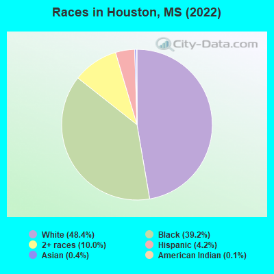
Races in Houston detailed stats: ancestries, foreign born residents, place of birth
According to our research of Mississippi and other state lists, there were 48 registered sex offenders living in Houston, Mississippi as of May 23, 2024.
The ratio of all residents to sex offenders in Houston is 74 to 1.
Full-time law enforcement employees in 2021, including police officers: 10 (10 officers - 9 male; 1 female).
| Officers per 1,000 residents here: | 2.98 |
| Mississippi average: | 2.18 |
 Recent articles from our blog. Our writers, many of them Ph.D. graduates or candidates, create easy-to-read articles on a wide variety of topics.

 | C&G Rail Trail (10 replies) |
| How "true" is Home Town about the city of Laurel? (12 replies) |
| Want to know why MS is last in all the good stuff and first in all the bad? Click here (81 replies) |
| Is white flight from Jackson ending? (152 replies) |
| Where does hurricane damage risk diminish to near zero? (18 replies) |
| Natchez Trace on way to Franklin Tn from DFW (17 replies) |
Latest news from Houston, MS collected exclusively by city-data.com from local newspapers, TV, and radio stations
Ancestries: American (21.8%), English (4.4%), Irish (3.8%), German (2.5%).
Current Local Time: CST time zone
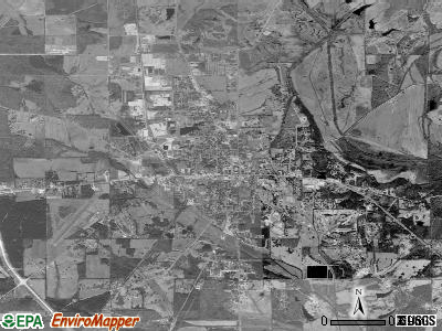
Land area: 7.59 square miles.
Population density: 489 people per square mile (low).
174 residents are foreign born (4.0% Latin America).
| This city: | 4.7% |
| Mississippi: | 2.3% |
Median real estate property taxes paid for housing units with mortgages in 2022: $1,002 (1.0%)
Median real estate property taxes paid for housing units with no mortgage in 2022: $1,314 (1.4%)
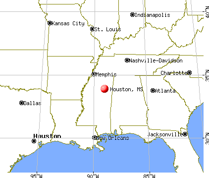
Nearest city with pop. 50,000+: Tuscaloosa, AL  (97.2 miles , pop. 77,906).
Nearest city with pop. 200,000+: Memphis, TN (100.8 miles , pop. 650,100).
Nearest city with pop. 1,000,000+: Dallas, TX (456.1 miles , pop. 1,188,580).
Nearest cities:
), ), )Latitude: 33.90 N, Longitude: 89.00 W
Daytime population change due to commuting: +1,512 (+40.4%)
Workers who live and work in this city: 677 (46.3%)
Area code: 662


Houston, Mississippi accommodation & food services, waste management - Economy and Business Data
Single-family new house construction building permits:
- 2022: 3 buildings, average cost: $116,000
- 2021: 2 buildings, average cost: $80,000
- 2020: 3 buildings, average cost: $92,000
- 2019: 1 building, cost: $100,000
- 2018: 1 building, cost: $100,000
- 2017: 1 building, cost: $70,000
- 2016: 4 buildings, average cost: $95,000
- 2015: 3 buildings, average cost: $81,300
- 2014: 3 buildings, average cost: $182,600
- 2013: 1 building, cost: $90,000
- 2012: 2 buildings, average cost: $194,300
- 2011: 1 building, cost: $85,000
- 2010: 2 buildings, average cost: $70,000
- 2009: 1 building, cost: $140,000
- 2008: 6 buildings, average cost: $54,000
- 2007: 4 buildings, average cost: $116,000
- 2006: 5 buildings, average cost: $78,600
- 2005: 1 building, cost: $44,000
- 2004: 8 buildings, average cost: $61,600
- 2003: 10 buildings, average cost: $61,800
- 2002: 9 buildings, average cost: $40,700
- 2001: 3 buildings, average cost: $46,700
- 2000: 4 buildings, average cost: $41,300
- 1999: 4 buildings, average cost: $38,800
- 1998: 7 buildings, average cost: $65,300
- 1997: 6 buildings, average cost: $97,300


| Here: | 3.3% |
| Mississippi: | 2.6% |


- Furniture & related product manufacturing (24.6%)
- Educational services (8.6%)
- Metal & metal products (6.2%)
- Construction (5.6%)
- Health care (4.4%)
- Public administration (3.9%)
- Electrical equipment, appliances, components (3.8%)

- Furniture & related product manufacturing (29.1%)
- Construction (9.5%)
- Public administration (6.2%)
- Agriculture, forestry, fishing & hunting (4.7%)
- Metal & metal products (4.4%)
- Repair & maintenance (3.8%)
- Electrical equipment, appliances, components (2.9%)

- Furniture & related product manufacturing (19.6%)
- Educational services (17.5%)
- Metal & metal products (8.1%)
- Health care (7.3%)
- Electrical equipment, appliances, components (4.8%)
- Accommodation & food services (4.7%)
- Department & other general merchandise stores (3.8%)

- Other production occupations, including supervisors (11.6%)
- Assemblers and fabricators (6.6%)
- Textile, apparel, and furnishings workers (6.4%)
- Other sales and related occupations, including supervisors (5.2%)
- Woodworkers (4.5%)
- Metal workers and plastic workers (4.2%)
- Preschool, kindergarten, elementary, and middle school teachers (3.8%)

- Other production occupations, including supervisors (12.7%)
- Other sales and related occupations, including supervisors (9.9%)
- Woodworkers (7.7%)
- Assemblers and fabricators (7.6%)
- Driver/sales workers and truck drivers (6.5%)
- Building and grounds cleaning and maintenance occupations (4.7%)
- Metal workers and plastic workers (4.4%)

- Textile, apparel, and furnishings workers (11.3%)
- Other production occupations, including supervisors (10.5%)
- Preschool, kindergarten, elementary, and middle school teachers (7.3%)
- Assemblers and fabricators (5.6%)
- Other office and administrative support workers, including supervisors (4.1%)
- Metal workers and plastic workers (3.9%)
- Material recording, scheduling, dispatching, and distributing workers (3.8%)
Average climate in Houston, Mississippi
Based on data reported by over 4,000 weather stations


|
|


Tornado activity:
Houston-area historical tornado activity is near Mississippi state average. It is 90% greater than the overall U.S. average.
On 4/29/1963, a category F4 (max. wind speeds 207-260 mph) tornado 22.3 miles away from the Houston city center killed 3 people and injured 20 people and caused between $50,000 and $500,000 in damages.
On 3/11/1963, a category F4 tornado 24.1 miles away from the city center killed 2 people and injured 7 people and caused between $5000 and $50,000 in damages.
Earthquake activity:
Houston-area historical earthquake activity is significantly above Mississippi state average. It is 247% greater than the overall U.S. average.On 3/25/1976 at 00:41:20, a magnitude 5.0 (4.9 MB, 5.0 LG, Class: Moderate, Intensity: VI - VII) earthquake occurred 141.9 miles away from the city center
On 1/18/1999 at 07:00:53, a magnitude 4.8 (4.8 MB, 4.0 LG, Depth: 0.6 mi, Class: Light, Intensity: IV - V) earthquake occurred 106.2 miles away from Houston center
On 6/24/1975 at 11:11:36, a magnitude 4.5 (4.5 MB) earthquake occurred 67.9 miles away from the city center
On 5/4/1991 at 01:18:54, a magnitude 5.0 (4.4 MB, 4.6 LG, 5.0 LG, Depth: 3.1 mi) earthquake occurred 190.1 miles away from Houston center
On 4/27/1989 at 16:47:49, a magnitude 4.7 (4.6 MB, 4.7 LG, 4.3 LG) earthquake occurred 152.1 miles away from Houston center
On 4/29/2003 at 08:59:39, a magnitude 4.9 (4.4 MB, 4.6 MW, 4.9 LG) earthquake occurred 197.3 miles away from Houston center
Magnitude types: regional Lg-wave magnitude (LG), body-wave magnitude (MB), moment magnitude (MW)
Natural disasters:
The number of natural disasters in Chickasaw County (17) is near the US average (15).Major Disasters (Presidential) Declared: 11
Emergencies Declared: 1
Causes of natural disasters: Storms: 11, Tornadoes: 10, Floods: 8, Winds: 8, Freezes: 3, Hurricanes: 2, Winter Storms: 2, Drought: 1, Heavy Rain: 1, Other: 1 (Note: some incidents may be assigned to more than one category).
Hospitals and medical centers in Houston:
Airports located in Houston:
- Houston Municipal Airport (M44) (Runways: 1, Itinerant Ops: 8,200, Local Ops: 6,000, Military Ops: 1,000)
- Kimmel Airport (2MS9) (Runways: 1)
- Shenandoah Valley Farms Airport (0MS9) (Runways: 1)
Colleges/universities with over 2000 students nearest to Houston:
- Mississippi State University (about 33 miles; Mississippi State, MS; Full-time enrollment: 18,237)
- Itawamba Community College (about 43 miles; Fulton, MS; FT enrollment: 5,489)
- Mississippi University for Women (about 44 miles; Columbus, MS; FT enrollment: 2,565)
- University of Mississippi (about 45 miles; University, MS; FT enrollment: 17,642)
- Northeast Mississippi Community College (about 59 miles; Booneville, MS; FT enrollment: 3,024)
- Northwest Mississippi Community College (about 75 miles; Senatobia, MS; FT enrollment: 6,607)
- East Mississippi Community College (about 80 miles; Scooba, MS; FT enrollment: 5,180)
Public high schools in Houston:
- HOUSTON HIGH SCHOOL (Location: 634 STARKVILLE ROAD, Grades: 6-12)
- HOUSTON VOC CENTER (Location: 634-A STARKVILLE ROAD, Grades: 9-12)
Public elementary/middle schools in Houston:
- HOUSTON MIDDLE SCHOOL (Location: 632-A STARKVILLE ROAD, Grades: 6-8)
- HOUSTON LOWER ELEMENTARY (Location: 123 STARKVILLE STREET, Grades: KG-2)
- HOUSTON UPPER ELEMENTARY (Location: 452 PITTSBORO STREET, Grades: 3-5)
Points of interest:
Notable locations in Houston: Carnegie Library (A), Houston City Hall (B), Chickasaw County Courthouse (C), Chickasaw County Coliseum (D), Houston Fire Department (E). Display/hide their locations on the map
Churches in Houston include: Church of our Lord (A), Church of the Living God (B), Faith Bible Church (C), Farrs Chapel Methodist Church (D), First Baptist Church (E), First United Pentecostal Church (F), Houston Church of God (G), Houston Church of the Nazarene (H), Houston Presbyterian Church (I). Display/hide their locations on the map
Creek: Soctahoma Creek (A). Display/hide its location on the map
Park in Houston: Joe Brigance Memorial Park (1). Display/hide its location on the map
Hotels: Holiday Terrace Motel (Highway 8 East), Western Inn & Suites (800 West Madison Street).
Courts: Chickasaw County - Justice Court Clerk (112 Logan Street), Gore James S Chancery Court Judge (200 North Jefferson Street), Chickasaw County - Justice Court Judge (Courthouse), Brand W W Jr Chancery Court Judge (200 North Jefferson Street).
Birthplace of: Howard Waldrop - Writer, Terry Catledge - Basketball player, Bobby Pepper - Journalist.
Drinking water stations with addresses in Houston and their reported violations in the past:
CITY OF HOUSTON (Population served: 3,623, Groundwater):Past monitoring violations:
- Monitoring and Reporting (DBP) - Between OCT-2013 and DEC-2013, Contaminant: Chlorine. Follow-up actions: St Public Notif requested (DEC-06-2013), St Formal NOV issued (DEC-06-2013), St Public Notif received (DEC-26-2013), St Compliance achieved (MAR-31-2014)
- One routine major monitoring violation
- One minor monitoring violation
- 217 regular monitoring violations
| This city: | 2.6 people |
| Mississippi: | 2.6 people |
| This city: | 67.7% |
| Whole state: | 69.0% |
| This city: | 5.0% |
| Whole state: | 5.7% |
No gay or lesbian households reported
70 people in nursing homes in 2000
50 people in local jails and other confinement facilities (including police lockups) in 2000
Banks with branches in Houston (2011 data):
- Regions Bank: Houston Northgate Office Branch at 905 North Jackson Street, branch established on 1974/03/23; Houston Branch at 117 North Jackson, branch established on 1919/12/01. Info updated 2011/02/24: Bank assets: $123,368.2 mil, Deposits: $98,301.3 mil, headquarters in Birmingham, AL, positive income, Commercial Lending Specialization, 1778 total offices, Holding Company: Regions Financial Corporation
- BancorpSouth Bank: North Jackson Street Branch at 821 North Jackson Street, branch established on 1978/07/28; Houston Branch at 115 East Washington Street, branch established on 1930/08/08. Info updated 2007/07/18: Bank assets: $12,990.3 mil, Deposits: $10,863.8 mil, headquarters in Tupelo, MS, positive income, Commercial Lending Specialization, 271 total offices, Holding Company: Bancorpsouth, Inc.
- Bank of Okolona: Houston Branch at 321 West Madison Street, branch established on 2008/05/05. Info updated 2010/06/02: Bank assets: $117.0 mil, Deposits: $100.2 mil, headquarters in Okolona, MS, positive income, Agricultural Specialization, 2 total offices, Holding Company: Bancorp Of Okolona
For population 15 years and over in Houston:

- Never married: 33.0%
- Now married: 41.3%
- Separated: 4.0%
- Widowed: 9.7%
- Divorced: 11.9%
For population 25 years and over in Houston:
- High school or higher: 73.1%
- Bachelor's degree or higher: 16.3%
- Graduate or professional degree: 5.6%
- Unemployed: 5.8%
- Mean travel time to work (commute): 15.2 minutes


| Here: | 17.0 |
| Mississippi average: | 11.8 |


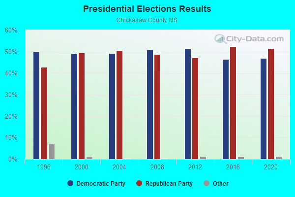
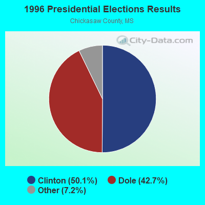
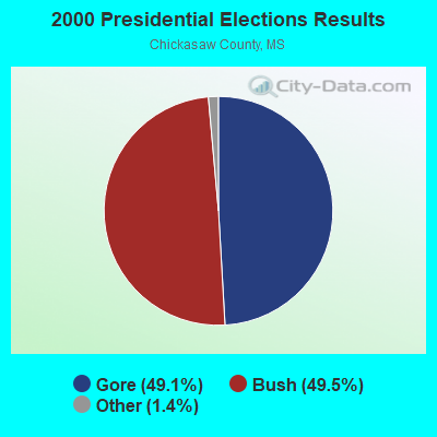

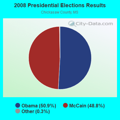
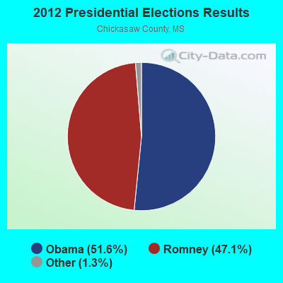
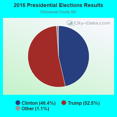

Graphs represent county-level data. Detailed 2008 Election Results
Religion statistics for Houston, MS (based on Chickasaw County data)
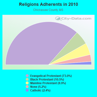
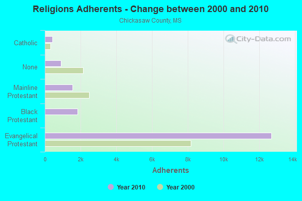
| Religion | Adherents | Congregations |
|---|---|---|
| Evangelical Protestant | 12,701 | 55 |
| Black Protestant | 1,832 | 13 |
| Mainline Protestant | 1,550 | 20 |
| Catholic | 409 | 2 |
| Other | 1 | 1 |
| None | 899 | - |
Food Environment Statistics:
| Chickasaw County: | 3.17 / 10,000 pop. |
| Mississippi: | 2.08 / 10,000 pop. |
| Here: | 1.58 / 10,000 pop. |
| State: | 0.80 / 10,000 pop. |
| This county: | 5.81 / 10,000 pop. |
| State: | 6.36 / 10,000 pop. |
| Here: | 1.58 / 10,000 pop. |
| Mississippi: | 5.03 / 10,000 pop. |
| Chickasaw County: | 12.9% |
| Mississippi: | 12.3% |
| This county: | 34.2% |
| Mississippi: | 33.1% |
| Chickasaw County: | 11.4% |
| State: | 14.4% |
Health and Nutrition:
| This city: | 48.1% |
| Mississippi: | 48.6% |
| Houston: | 43.8% |
| Mississippi: | 45.3% |
| This city: | 29.5 |
| Mississippi: | 29.2 |
| Here: | 21.0% |
| Mississippi: | 20.5% |
| Houston: | 13.2% |
| Mississippi: | 11.6% |
| Here: | 6.8 |
| State: | 6.7 |
| This city: | 35.5% |
| Mississippi: | 34.8% |
| Houston: | 52.9% |
| Mississippi: | 54.9% |
| This city: | 78.5% |
| Mississippi: | 79.9% |
More about Health and Nutrition of Houston, MS Residents
| Local government employment and payroll (March 2022) | |||||
| Function | Full-time employees | Monthly full-time payroll | Average yearly full-time wage | Part-time employees | Monthly part-time payroll |
|---|---|---|---|---|---|
| Police Protection - Officers | 8 | $25,367 | $38,051 | 0 | $0 |
| Firefighters | 6 | $20,633 | $41,266 | 0 | $0 |
| Streets and Highways | 4 | $10,987 | $32,961 | 1 | $1,661 |
| Other Government Administration | 4 | $13,016 | $39,048 | 4 | $2,081 |
| Police - Other | 2 | $6,725 | $40,350 | 3 | $1,251 |
| Local Libraries | 2 | $4,185 | $25,110 | 0 | $0 |
| Fire - Other | 1 | $4,683 | $56,196 | 0 | $0 |
| Water Supply | 1 | $2,967 | $35,604 | 0 | $0 |
| Sewerage | 1 | $2,832 | $33,984 | 0 | $0 |
| Financial Administration | 1 | $3,472 | $41,664 | 0 | $0 |
| Totals for Government | 30 | $94,867 | $37,947 | 8 | $4,993 |
Houston government finances - Expenditure in 2017 (per resident):
- Construction - Sewerage: $173,000 ($46.64)
General Public Buildings: $99,000 ($26.69)
Regular Highways: $22,000 ($5.93)
Local Fire Protection: $6,000 ($1.62)
Central Staff Services: $5,000 ($1.35)
Police Protection: $3,000 ($0.81)
- Current Operations - Water Utilities: $619,000 ($166.89)
Police Protection: $466,000 ($125.64)
General - Other: $448,000 ($120.79)
Regular Highways: $342,000 ($92.21)
Local Fire Protection: $259,000 ($69.83)
Central Staff Services: $255,000 ($68.75)
Sewerage: $205,000 ($55.27)
Solid Waste Management: $202,000 ($54.46)
Parks and Recreation: $123,000 ($33.16)
General Public Buildings: $55,000 ($14.83)
Libraries: $55,000 ($14.83)
Judicial and Legal Services: $51,000 ($13.75)
Air Transportation: $10,000 ($2.70)
- Total Salaries and Wages: $1,085,000 ($292.53)
- Water Utilities - Interest on Debt: $236,000 ($63.63)
Houston government finances - Revenue in 2017 (per resident):
- Charges - Solid Waste Management: $218,000 ($58.78)
Parks and Recreation: $55,000 ($14.83)
Air Transportation: $6,000 ($1.62)
- Miscellaneous - Rents: $173,000 ($46.64)
Fines and Forfeits: $27,000 ($7.28)
Interest Earnings: $15,000 ($4.04)
General Revenue - Other: $2,000 ($0.54)
- Revenue - Water Utilities: $1,373,000 ($370.18)
- State Intergovernmental - General Local Government Support: $1,077,000 ($290.37)
Water Utilities: $250,000 ($67.40)
Other: $123,000 ($33.16)
Housing and Community Development: $121,000 ($32.62)
Highways: $39,000 ($10.51)
- Tax - Property: $2,131,000 ($574.55)
Occupation and Business License - Other: $11,000 ($2.97)
Motor Fuels Sales: $4,000 ($1.08)
Houston government finances - Debt in 2017 (per resident):
- Long Term Debt - Beginning Outstanding - Unspecified Public Purpose: $5,903,000 ($1591.53)
Outstanding Unspecified Public Purpose: $5,572,000 ($1502.29)
Retired Unspecified Public Purpose: $330,000 ($88.97)
Houston government finances - Cash and Securities in 2017 (per resident):
- Sinking Funds - Cash and Securities: $1,741,000 ($469.40)
| Businesses in Houston, MS | ||||
| Name | Count | Name | Count | |
|---|---|---|---|---|
| AT&T | 1 | Penske | 1 | |
| AutoZone | 1 | Pizza Hut | 1 | |
| Chevrolet | 1 | RadioShack | 1 | |
| H&R Block | 1 | SONIC Drive-In | 1 | |
| Hardee's | 1 | Subway | 1 | |
| KFC | 1 | UPS | 1 | |
| McDonald's | 1 | Walmart | 1 | |
Strongest AM radio stations in Houston:
- WCPC (940 AM; 50 kW; HOUSTON, MS; Owner: WCPC BROADCASTING CO., INC.)
- WCRV (640 AM; 50 kW; COLLIERVILLE, TN; Owner: BOTT BROADCASTING COMPANY/TENNESSEE)
- WJOX (690 AM; 50 kW; BIRMINGHAM, AL; Owner: CITADEL BROADCASTING COMPANY)
- WGSF (1030 AM; 50 kW; MEMPHIS, TN; Owner: FLINN BROADCASTING CORPORATION)
- WDIA (1070 AM; 50 kW; MEMPHIS, TN; Owner: CLEAR CHANNEL BROADCASTING LICENSES, INC.)
- WDJC (850 AM; 50 kW; BIRMINGHAM, AL; Owner: KIMTRON, INC.)
- WMQM (1600 AM; 50 kW; LAKELAND, TN; Owner: WMQM, INC.)
- WAPI (1070 AM; 50 kW; BIRMINGHAM, AL; Owner: CITADEL BROADCASTING COMPANY)
- WSJC (810 AM; 50 kW; MAGEE, MS; Owner: FAMILY TALK RADIO)
- WJNT (1180 AM; 50 kW; PEARL, MS; Owner: BUCHANAN BROADCASTING CO., INC.)
- WFTO (1330 AM; 5 kW; FULTON, MS; Owner: AIR SOUTH RADIO, INC.)
- WSM (650 AM; 50 kW; NASHVILLE, TN; Owner: GAYLORD ENTERTAINMENT COMPANY)
- WNSI (810 AM; 50 kW; JACKSONVILLE, AL; Owner: UNITED BROADCASTING NETWORK, INC.)
Strongest FM radio stations in Houston:
- WGWT-LP (103.7 FM; HOUSTON, MS; Owner: COMPASS POINTS EDUCATIONAL FOUNDATION, INC.)
- WSYE (93.3 FM; HOUSTON, MS; Owner: JMD, INC.)
- WWMS (97.5 FM; OXFORD, MS; Owner: SAN-DOW BROADCASTING, INC.)
- WAJS (91.7 FM; TUPELO, MS; Owner: AMERICAN FAMILY ASSOCIATION)
- WJZB (88.9 FM; STARKVILLE, MS; Owner: AMERICAN FAMILY ASSOCIATION, INC.)
- WZLQ (98.5 FM; TUPELO, MS; Owner: SAN DOW BROADCASTING)
- WCMR (94.5 FM; BRUCE, MS; Owner: RUSSELL A HUMPHREY & ROBERTA L EATON)
- WWKZ (105.3 FM; ABERDEEN, MS; Owner: CAPSTAR TX LIMITED PARTNERSHIP)
- WMAB-FM (89.9 FM; ACKERMAN, MS; Owner: MISSISSIPPI AUTHORITY FOR EDUCATIONAL TV)
- WLZA (96.1 FM; EUPORA, MS; Owner: TRI COUNTY BROADCASTING)
- WFCA (107.9 FM; ACKERMAN, MS; Owner: FRENCH CAMP RADIO, INC.)
- WMAV-FM (90.3 FM; OXFORD, MS; Owner: MISSISSIPPI AUTHORITY FOR EDUCATIONAL TV)
- WSEL-FM (96.7 FM; PONTOTOC, MS; Owner: OLLIE COLLINS, JR.)
- WMBC (103.1 FM; COLUMBUS, MS; Owner: CUMULUS LICENSING CORP.)
TV broadcast stations around Houston:
- WTVA (Channel 9; TUPELO, MS; Owner: WTVA, INC.)
- WKDH (Channel 45; HOUSTON, MS; Owner: SOUTHERN BROADCASTING, INC.)
- WLOV-TV (Channel 27; WEST POINT, MS; Owner: LINGARD BROADCASTING CORPORATION)
- WCBI-TV (Channel 4; COLUMBUS, MS; Owner: COLUMBUS TELEVISION, INC.)
- WMAB-TV (Channel 2; MISSISSIPPI STATE, MS; Owner: MISSISSIPPI AUTHORITY FOR EDUCATIONAL TV)
- WMAV-TV (Channel 18; OXFORD, MS; Owner: MISSISSIPPI AUTHORITY FOR EDUCATIONAL TELEVISION)
- W07BN (Channel 7; BRUCE, MS; Owner: BRUCE INDEPENDENT TV, INC.)
- W32BH (Channel 32; TUPELO, MS; Owner: WTVA, INC.)
- W49BK (Channel 49; ACTON, TN; Owner: MS COMMUNICATIONS, LLC)
- W14BW (Channel 14; ACTON, TN; Owner: MS COMMUNICATIONS, LLC)

- National Bridge Inventory (NBI) Statistics
- 76Number of bridges
- 709ft / 216mTotal length
- $1,325,800,000Total costs
- 133,772Total average daily traffic
- 14,086Total average daily truck traffic

- New bridges - historical statistics
- 51930-1939
- 81940-1949
- 21950-1959
- 101960-1969
- 31970-1979
- 121980-1989
- 261990-1999
- 92000-2009
- 12010-2019
FCC Registered Cell Phone Towers:
2 (See the full list of FCC Registered Cell Phone Towers in Houston)FCC Registered Antenna Towers:
137 (See the full list of FCC Registered Antenna Towers)FCC Registered Commercial Land Mobile Towers:
1 (See the full list of FCC Registered Commercial Land Mobile Towers in Houston, MS)FCC Registered Private Land Mobile Towers:
1 (See the full list of FCC Registered Private Land Mobile Towers)FCC Registered Broadcast Land Mobile Towers:
10 (See the full list of FCC Registered Broadcast Land Mobile Towers)FCC Registered Microwave Towers:
5- HOUSTON, 102 Jefferson (Lat: 33.878361 Lon: -88.984944), Type: Gtower, Structure height: 123.1 m, Overall height: 128.9 m, Call Sign: WPNC699,
Assigned Frequencies: 5945.20 MHz, 6004.50 MHz, Grant Date: 01/05/2021, Expiration Date: 02/01/2031, Certifier: Carol L Tacker, Registrant: At&t Services, Inc., 208 S Akard St, 20f, Dallas, TX 75202, Phone: (855) 699-7073, Email:
- HOUSTON MS R, 130 County Route 210 (Lat: 33.929722 Lon: -89.018611), Type: Gtower, Structure height: 121.9 m, Overall height: 128 m, Call Sign: WQQJ894,
Assigned Frequencies: 10875.0 MHz, 10915.0 MHz, 10875.0 MHz, 10915.0 MHz, 10875.0 MHz, 10915.0 MHz, Grant Date: 01/10/2013, Expiration Date: 01/10/2023, Cancellation Date: 05/05/2014, Certifier: Chris Harris, Registrant: Conterra Ultra Broadband, LLC, 2101 Rexford Rd, Ste 200e, Charlotte, NC 28211, Phone: (704) 936-1801, Fax: (704) 936-1801, Email:
- 9ME0633A, 879 North Jefferson Street (Lat: 33.914083 Lon: -88.998250), Type: Gtower, Structure height: 57.9 m, Overall height: 60.9 m, Call Sign: WQWG550,
Assigned Frequencies: 6063.80 MHz, 6123.10 MHz, 6063.80 MHz, 6123.10 MHz, 6063.80 MHz, 6123.10 MHz, 6063.80 MHz, 6123.10 MHz, 6063.80 MHz, 6123.10 MHz... (+12 more), Grant Date: 08/14/2015, Expiration Date: 08/14/2025, Certifier: David Werblow, Registrant: T-Mobile Usa, Inc., 12920 Se 38th Street, Bellevue, WA 98006, Phone: (425) 383-8401, Fax: (425) 383-4040, Email:
- HOUSTON BYPASS, 280 County Road 210 (Lat: 33.929972 Lon: -89.024556), Type: Gtower, Structure height: 108.2 m, Overall height: 111.3 m, Call Sign: WRWU365,
Assigned Frequencies: 6197.24 MHz, 6226.89 MHz, 6256.54 MHz, 6286.19 MHz, Grant Date: 03/28/2023, Expiration Date: 03/28/2033, Certifier: Cecil J Mathew, Registrant: At&t Services, Inc., 208 S Akard St, 20f, Dallas, TX 75202, Phone: (855) 699-7073, Email:
- HWY 8/HWY 47, 579 Hwy 47 (Lat: 33.841361 Lon: -88.830917), Type: Ltower, Structure height: 91.4 m, Overall height: 94.7 m, Call Sign: WSCB579,
Assigned Frequencies: 10995.0 MHz, 10995.0 MHz, 10995.0 MHz, 10995.0 MHz, 10995.0 MHz, 10995.0 MHz, 10995.0 MHz, 10995.0 MHz, 10995.0 MHz, 10995.0 MHz, Grant Date: 03/26/2024, Expiration Date: 03/26/2034, Certifier: Cassie Myers, Registrant: Cellular South Licenses, LLC, 1018 Highland Colony Parkway, Suite 210, Ridgeland, MS 39157, Phone: (601) 974-7635, Fax: (601) 974-7107, Email:
FCC Registered Amateur Radio Licenses:
42 (See the full list of FCC Registered Amateur Radio Licenses in Houston)FAA Registered Aircraft:
11 (See the full list of FAA Registered Aircraft in Houston)2002 - 2018 National Fire Incident Reporting System (NFIRS) incidents
- Fire incident types reported to NFIRS in Houston, MS
- 66746.9%Outside Fires
- 54838.5%Structure Fires
- 19813.9%Mobile Property/Vehicle Fires
- 100.7%Other
 Based on the data from the years 2002 - 2018 the average number of fires per year is 84. The highest number of reported fires - 123 took place in 2010, and the least - 37 in 2002. The data has an increasing trend.
 When looking into fire subcategories, the most reports belonged to: Outside Fires (46.9%), and Structure Fires (38.5%).
| Most common first names in Houston, MS among deceased individuals | ||
| Name | Count | Lived (average) |
|---|---|---|
| James | 109 | 71.7 years |
| William | 85 | 73.9 years |
| John | 81 | 74.3 years |
| Mary | 65 | 78.3 years |
| Robert | 44 | 74.4 years |
| Willie | 41 | 74.3 years |
| Charles | 37 | 62.3 years |
| Annie | 36 | 82.7 years |
| George | 36 | 73.6 years |
| Thomas | 33 | 72.2 years |
| Most common last names in Houston, MS among deceased individuals | ||
| Last name | Count | Lived (average) |
|---|---|---|
| Smith | 68 | 76.7 years |
| Davis | 49 | 75.9 years |
| Griffin | 42 | 73.2 years |
| Gann | 35 | 75.8 years |
| Johnson | 30 | 70.1 years |
| Criddle | 29 | 73.6 years |
| Moore | 29 | 72.2 years |
| Williams | 25 | 72.9 years |
| Clark | 25 | 80.6 years |
| Dendy | 25 | 74.8 years |

- 57.3%Utility gas
- 39.6%Electricity
- 1.8%No fuel used
- 1.3%Bottled, tank, or LP gas

- 55.7%Utility gas
- 38.2%Electricity
- 4.4%Bottled, tank, or LP gas
- 1.7%No fuel used
Houston compared to Mississippi state average:
- Median household income below state average.
- Median house value below state average.
- Unemployed percentage below state average.
- Foreign-born population percentage above state average.
- Length of stay since moving in significantly above state average.
- Number of college students below state average.

|
Total of 2 patent applications in 2008-2024.