Hartford, Georgia
Submit your own pictures of this place and show them to the world
- OSM Map
- General Map
- Google Map
- MSN Map

| Males: 835 | |
| Females: 1,842 |
| Median resident age: | 34.9 years |
| Georgia median age: | 33.4 years |
Zip code: 31036
| Hartford: | $41,076 |
| GA: | $72,837 |
Estimated per capita income in 2022: $15,873 (it was $11,179 in 2000)
Hartford CCD income, earnings, and wages data
Estimated median house or condo value in 2022: $116,957 (it was $57,300 in 2000)
| Hartford: | $116,957 |
| GA: | $297,400 |
Mean prices in 2022: all housing units: $217,810; detached houses: $250,424; mobile homes: $90,335
Detailed information about poverty and poor residents in Hartford, GA


- 1,59661.0%White alone
- 92035.2%Black alone
- 652.5%Hispanic
- 210.8%Two or more races
- 90.3%American Indian alone
- 40.2%Asian alone
- 10.04%Other race alone

Races in Hartford detailed stats: ancestries, foreign born residents, place of birth
 Recent articles from our blog. Our writers, many of them Ph.D. graduates or candidates, create easy-to-read articles on a wide variety of topics.
Current Local Time: EST time zone
Elevation: 233 feet
Land area: 83.9 square miles.
Population density: 32 people per square mile (very low).

| Hartford CCD: | 0.7% ($384) |
| Georgia: | 0.9% ($919) |
Nearest city with pop. 50,000+: Macon, GA  (43.5 miles , pop. 97,255).
Nearest city with pop. 200,000+: Atlanta, GA (120.0 miles , pop. 416,474).
Nearest city with pop. 1,000,000+: Chicago, IL (704.4 miles , pop. 2,896,016).
Nearest cities:
), ), )Latitude: 32.24 N, Longitude: 83.39 W
Area code commonly used in this area: 478


| Here: | 3.1% |
| Georgia: | 2.9% |

- Construction (10.3%)
- Health care (10.1%)
- Public administration (7.0%)
- Textile mills & textile products (5.9%)
- Educational services (5.4%)
- Agriculture, forestry, fishing & hunting (4.2%)
- Repair & maintenance (4.0%)

- Construction (18.5%)
- Agriculture, forestry, fishing & hunting (8.1%)
- Public administration (7.1%)
- Transportation equipment (6.9%)
- Repair & maintenance (5.9%)
- Health care (5.9%)
- Administrative & support & waste management services (5.0%)

- Health care (14.7%)
- Educational services (10.1%)
- Textile mills & textile products (9.0%)
- Public administration (7.0%)
- Finance & insurance (6.4%)
- Personal & laundry services (5.9%)
- Building material & garden equipment & supplies dealers (4.9%)

- Electrical equipment mechanics and other installation, maintenance, and repair workers, including supervisors (7.3%)
- Textile, apparel, and furnishings workers (6.2%)
- Construction laborers (5.4%)
- Financial clerks, except bookkeeping, accounting and auditing clerks (5.3%)
- Vehicle and mobile equipment mechanics, installers, and repairers (5.2%)
- Secretaries and administrative assistants (4.8%)
- Building and grounds cleaning and maintenance occupations (4.7%)

- Electrical equipment mechanics and other installation, maintenance, and repair workers, including supervisors (12.4%)
- Vehicle and mobile equipment mechanics, installers, and repairers (10.0%)
- Construction laborers (9.3%)
- Building and grounds cleaning and maintenance occupations (9.0%)
- Other production occupations, including supervisors (5.2%)
- Assemblers and fabricators (5.0%)
- Farmers and farm managers (3.8%)

- Textile, apparel, and furnishings workers (11.3%)
- Financial clerks, except bookkeeping, accounting and auditing clerks (11.1%)
- Secretaries and administrative assistants (10.1%)
- Health technologists and technicians (5.2%)
- Personal appearance workers (4.9%)
- Bookkeeping, accounting, and auditing clerks (4.6%)
- Preschool, kindergarten, elementary, and middle school teachers (3.9%)
Average climate in Hartford, Georgia
Based on data reported by over 4,000 weather stations


Tornado activity:
Hartford-area historical tornado activity is near Georgia state average. It is 28% greater than the overall U.S. average.
On 4/30/1953, a category F4 (max. wind speeds 207-260 mph) tornado 27.4 miles away from the Hartford place center killed 18 people and injured 300 people and caused between $5,000,000 and $50,000,000 in damages.
On 3/31/1961, a category F3 (max. wind speeds 158-206 mph) tornado 19.6 miles away from the place center killed one person and injured 14 people and caused between $500,000 and $5,000,000 in damages.
Earthquake activity:
Hartford-area historical earthquake activity is significantly above Georgia state average. It is 9% smaller than the overall U.S. average.On 8/2/1974 at 08:52:09, a magnitude 4.9 (4.3 MB, 4.9 LG, Class: Light, Intensity: IV - V) earthquake occurred 124.2 miles away from the city center
On 4/29/2003 at 08:59:39, a magnitude 4.9 (4.4 MB, 4.6 MW, 4.9 LG) earthquake occurred 202.2 miles away from the city center
On 11/22/1974 at 05:25:55, a magnitude 4.7 (4.7 MB) earthquake occurred 194.7 miles away from the city center
On 10/24/1997 at 08:35:17, a magnitude 4.9 (4.8 MB, 4.2 MS, 4.9 LG, Depth: 6.2 mi) earthquake occurred 241.0 miles away from Hartford center
On 1/18/1999 at 07:00:53, a magnitude 4.8 (4.8 MB, 4.0 LG, Depth: 0.6 mi) earthquake occurred 238.3 miles away from Hartford center
On 4/29/2003 at 08:59:39, a magnitude 4.6 (4.6 MW, Depth: 12.3 mi) earthquake occurred 202.2 miles away from Hartford center
Magnitude types: regional Lg-wave magnitude (LG), body-wave magnitude (MB), surface-wave magnitude (MS), moment magnitude (MW)
Natural disasters:
The number of natural disasters in Pulaski County (9) is smaller than the US average (15).Major Disasters (Presidential) Declared: 6
Emergencies Declared: 2
Causes of natural disasters: Floods: 4, Tornadoes: 4, Storms: 3, Hurricanes: 2, Tropical Storms: 2, Drought: 1, Heavy Rain: 1, Wind: 1, Other: 1 (Note: some incidents may be assigned to more than one category).
Hospitals and medical centers near Hartford:
- PINEWOOD MANOR (Nursing Home, about 6 miles away; HAWKINSVILLE, GA)
- BLECKLEY MEMORIAL HOSPITAL Critical Access Hospitals (about 10 miles away; COCHRAN, GA)
- CROSSVIEW CARE CENTER (Nursing Home, about 12 miles away; PINEVIEW, GA)
- EASTMAN HEALTHCARE AND REHAB (Nursing Home, about 13 miles away; EASTMAN, GA)
- DODGE COUNTY HOSPITAL Acute Care Hospitals (about 14 miles away; EASTMAN, GA)
- THREE RIVERS HOME HEALTH SERVICES, INC (Home Health Center, about 14 miles away; EASTMAN, GA)
Colleges/universities with over 2000 students nearest to Hartford:
- Central Georgia Technical College (about 27 miles; Warner Robins, GA; Full-time enrollment: 6,829)
- Fort Valley State University (about 36 miles; Fort Valley, GA; FT enrollment: 3,200)
- Mercer University (about 44 miles; Macon, GA; FT enrollment: 6,297)
- Middle Georgia State College (about 44 miles; Macon, GA; FT enrollment: 7,091)
- Georgia Southwestern State University (about 50 miles; Americus, GA; FT enrollment: 2,689)
- Abraham Baldwin Agricultural College (about 54 miles; Tifton, GA; FT enrollment: 2,564)
- Georgia Military College-Distance Learning Campuses (about 59 miles; Milledgeville, GA; FT enrollment: 6,438)
Points of interest:
Churches in Hartford include: Harmony Church (A), Lizzie Bloomer Church (B), Midway Church (C), Mount Cilla Church (D), Salem Church (E), Corinth Church (F), Hartford Baptist Church (G), Mount Marriah Church (H). Display/hide their locations on the map
Cemeteries: Lampkin Cemetery (1), Sapp Cemetery (2), Lowe Cemetery (3), Bohanon Cemetery (4), Simmons Cemetery (5), Daniels Cemetery (6), Union Cemetery (7). Display/hide their locations on the map
Reservoirs: South Royce Lake (A), Suzies Lake (B), Bledsoe Pond (C), Hadden Lake (D), Hardy Lake (E), Bembry Lake (F), North Royce Lake (G). Display/hide their locations on the map
Streams, rivers, and creeks: Mosquito Creek (A), Big Creek (B), Jordan Creek (C), Hanley Branch (D), Double Branch (E), Cross Creek (F), Carden Branch (G), Limestone Creek (H). Display/hide their locations on the map
| This place: | 2.4 people |
| Georgia: | 2.6 people |
| This place: | 67.3% |
| Whole state: | 68.5% |
| This place: | 7.6% |
| Whole state: | 5.9% |
Likely homosexual households (counted as self-reported same-sex unmarried-partner households)
- Lesbian couples: 0.8% of all households
- Gay men: 0.7% of all households
| This place: | 10.9% |
| Whole state: | 13.0% |
| This place: | 6.0% |
| Whole state: | 6.1% |
975 people in state prisons in 2000
For population 15 years and over in Hartford:

- Never married: 21.2%
- Now married: 64.0%
- Separated: 3.4%
- Widowed: 4.8%
- Divorced: 10.0%
For population 25 years and over in Hartford:
- High school or higher: 69.1%
- Bachelor's degree or higher: 6.1%
- Graduate or professional degree: 1.1%
- Unemployed: 4.3%
- Mean travel time to work (commute): 25.5 minutes


| Here: | 10.3 |
| Georgia average: | 13.3 |
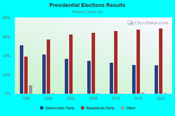
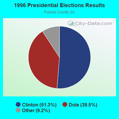
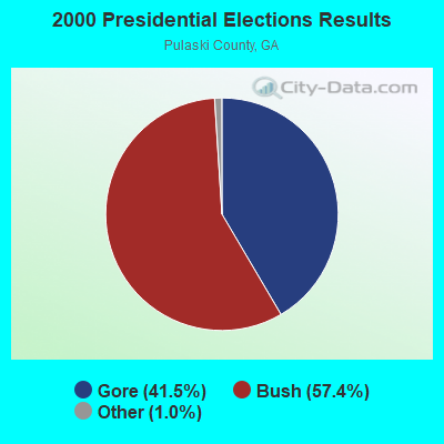

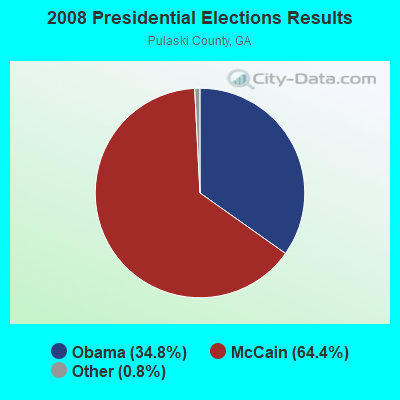
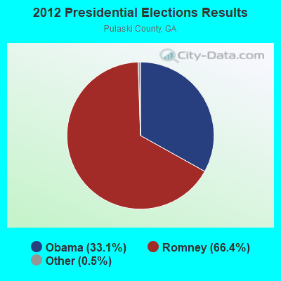


Graphs represent county-level data. Detailed 2008 Election Results
Religion statistics for Hartford, GA (based on Pulaski County data)
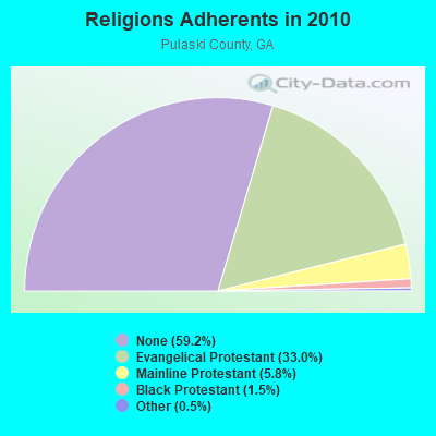
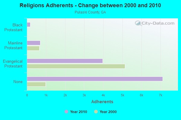
| Religion | Adherents | Congregations |
|---|---|---|
| Evangelical Protestant | 3,959 | 17 |
| Mainline Protestant | 694 | 2 |
| Black Protestant | 180 | 1 |
| Other | 62 | 1 |
| Catholic | - | - |
| None | 7,115 | - |
Food Environment Statistics:
| Pulaski County: | 2.04 / 10,000 pop. |
| State: | 1.91 / 10,000 pop. |
| This county: | 2.04 / 10,000 pop. |
| Georgia: | 0.86 / 10,000 pop. |
| Here: | 9.18 / 10,000 pop. |
| State: | 5.12 / 10,000 pop. |
| This county: | 8.16 / 10,000 pop. |
| Georgia: | 7.41 / 10,000 pop. |
| Pulaski County: | 12.4% |
| Georgia: | 10.4% |
| This county: | 31.6% |
| State: | 27.8% |
| Pulaski County: | 19.1% |
| State: | 14.6% |
Strongest AM radio stations in Hartford:
- WCEH (610 AM; 0 kW; HAWKINSVILLE, GA; Owner: TRI-COUNTY BROADCASTING CO., INC.)
- WUFF (710 AM; daytime; 2 kW; EASTMAN, GA; Owner: FARNELL O'QUINN)
- WMAC (940 AM; 50 kW; MACON, GA; Owner: CUMULUS LICENSING CORP.)
- WNNG (1350 AM; 15 kW; WARNER ROBINS, GA; Owner: CHASE BROADCASTING, INC.)
- WKTF (1550 AM; 10 kW; VIENNA, GA; Owner: SANTILLANA BROADCASTING, INC.)
- WPGA (980 AM; 5 kW; PERRY, GA; Owner: RADIO PERRY, INC.)
- WVMG (1440 AM; 1 kW; COCHRAN, GA; Owner: CLEVELAND RADIO LICENSES, LLC)
- WXJO (1120 AM; daytime; 10 kW; GORDON, GA; Owner: ROBERTS COMMUNICATIONS, INC.)
- WGST (640 AM; 50 kW; ATLANTA, GA; Owner: CITICASTERS LICENSES, L.P.)
- WSB (750 AM; 50 kW; ATLANTA, GA; Owner: CXR HOLDINGS, INC.)
- WCNN (680 AM; 50 kW; NORTH ATLANTA, GA; Owner: DICKEY BROADCASTING COMPANY)
- WGUN (1010 AM; 50 kW; ATLANTA, GA; Owner: WGUN, INC.)
- WFVR (910 AM; 50 kW; VALDOSTA, GA; Owner: RAMA COMMUNICATIONS, INC.)
Strongest FM radio stations in Hartford:
- WQIL (101.3 FM; CHAUNCEY, GA; Owner: GSW, INC.)
- WDCO-FM (89.7 FM; COCHRAN, GA; Owner: GEORGIA PUBLIC TELECOMMUNICATIONS COMMISSION)
- WUFF-FM (97.5 FM; EASTMAN, GA; Owner: FARNELL O'QUINN)
- WMCG (104.9 FM; MILAN, GA; Owner: TEL-DODGE BROADCASTING CO.)
- WQSY (103.9 FM; HAWKINSVILLE, GA; Owner: TRI-COUNTY BROADCASTING, INC.)
- WVMG-FM (96.7 FM; COCHRAN, GA; Owner: CLEVELAND RADIO LICENSES, LLC)
- WPEZ (93.7 FM; JEFFERSONVILLE, GA; Owner: CUMULUS LICENSING CORP.)
- WCOP-FM (99.9 FM; UNADILLA, GA; Owner: TOCCOA FALLS COLLEGE)
- WIBB-FM (97.9 FM; FORT VALLEY, GA; Owner: CLEVELAND RADIO LICENSES, LLC)
- WPGA-FM (100.9 FM; PERRY, GA; Owner: RADIO PERRY, INC.)
TV broadcast stations around Hartford:
- WDCO-TV (Channel 29; COCHRAN, GA; Owner: GEORGIA PUBLIC TELECOMMUNICATIONS COMMISSION)
- WPGA-TV (Channel 58; PERRY, GA; Owner: RADIO PERRY, INC.)
- WMGT-TV (Channel 41; MACON, GA; Owner: MORRIS NETWORK, INC.)
- WMAZ-TV (Channel 13; MACON, GA; Owner: GANNETT GEORGIA, L.P.)
- WGXA (Channel 24; MACON, GA; Owner: PIEDMONT TELEVISION OF MACON LICENSE LLC)
- WGNM (Channel 64; MACON, GA; Owner: GOOD NEWS TELEVISION)
- National Bridge Inventory (NBI) Statistics
- 1Number of bridges
- 23ft / 6.6mTotal length
- $1,266,000Total costs
- 9,440Total average daily traffic
- 94Total average daily truck traffic
- 14,160Total future (year 2031) average daily traffic
FCC Registered Antenna Towers:
4- Cecil Staton, Near (Lat: 32.280833 Lon: -83.441667), Type: 93.0, Overall height: 92 m, Registrant: Staton Broadcasting, Inc., Statonstations@aol.Com, , Macon, Phone: (478) 301-2117
- Cecil Staton, Near (Lat: 32.280833 Lon: -83.441667), Type: 93.0, Overall height: 92 m, Registrant: Georgia Eagle Media, Inc., 6316@helwys.Com, , Macon, Phone: (478) 757-0564
- Dan J Alpert, Near (Lat: 32.280833 Lon: -83.441667), Type: 93.0, Overall height: 92 m, Registrant: The Law Office Of Dan J. Alpert, Dja@commlaw.Tv, , Arlin-gton, Phone: (703) 243-8690
- Near (Lat: 32.280833 Lon: -83.441667), Type: 93.0, Overall height: 92 m, Registrant: Tri County Broadcasting Co Inc Dba , 180 Hawki-nsville, Phone: (912) 783-1109

- 46.5%Electricity
- 33.2%Bottled, tank, or LP gas
- 19.0%Utility gas
- 1.3%Wood

- 47.6%Bottled, tank, or LP gas
- 31.5%Utility gas
- 20.8%Electricity
Hartford compared to Georgia state average:
- Median household income below state average.
- Median house value significantly below state average.
- Unemployed percentage significantly below state average.
- Hispanic race population percentage significantly below state average.
- Median age below state average.
- Foreign-born population percentage significantly below state average.
- Renting percentage below state average.
- Length of stay since moving in significantly above state average.
- Number of rooms per house significantly below state average.
- House age significantly below state average.
- Institutionalized population percentage significantly above state average.
- Number of college students below state average.
- Percentage of population with a bachelor's degree or higher significantly below state average.
Hartford on our top lists:
- #4 on the list of "Top 100 cities with the largest percentage of females"
- #50 on the list of "Top 101 cities with the largest percentage of people in state prisons (population 1,000+)"