Grahn, Kentucky
Submit your own pictures of this place and show them to the world
- OSM Map
- General Map
- Google Map
- MSN Map

| Males: 1,573 | |
| Females: 1,558 |
| Median resident age: | 37.8 years |
| Kentucky median age: | 35.9 years |
Zip code: 41143
| Grahn: | $42,429 |
| KY: | $59,341 |
Estimated per capita income in 2022: $23,423 (it was $12,447 in 2000)
Grahn CCD income, earnings, and wages data
Estimated median house or condo value in 2022: $119,221 (it was $41,400 in 2000)
| Grahn: | $119,221 |
| KY: | $196,300 |
Mean prices in 2022: all housing units: $146,454; detached houses: $165,822; townhouses or other attached units: $187,658; mobile homes: $82,189
Detailed information about poverty and poor residents in Grahn, KY


- 3,02998.3%White alone
- 301.0%Hispanic
- 140.5%Two or more races
- 30.10%American Indian alone
- 20.06%Black alone
- 20.06%Asian alone

Races in Grahn detailed stats: ancestries, foreign born residents, place of birth
 Recent articles from our blog. Our writers, many of them Ph.D. graduates or candidates, create easy-to-read articles on a wide variety of topics.
Current Local Time: EST time zone
Elevation: 680 feet
Land area: 70.5 square miles.
Population density: 44 people per square mile (very low).

| Grahn CCD: | 0.7% ($271) |
| Kentucky: | 0.8% ($610) |
Nearest city with pop. 50,000+: Huntington, WV  (35.1 miles , pop. 51,475).
Nearest city with pop. 200,000+: Fayette, KY (80.0 miles , pop. 260,512).
Nearest city with pop. 1,000,000+: Chicago, IL (347.1 miles , pop. 2,896,016).
Nearest cities:
), ), ), ), ), )Latitude: 38.28 N, Longitude: 83.06 W
Area code commonly used in this area: 606


| Here: | 7.2% |
| Kentucky: | 3.8% |

- Construction (11.8%)
- Educational services (8.5%)
- Broadcasting & telecommunications (8.2%)
- Health care (6.3%)
- Metal & metal products (5.0%)
- Public administration (4.7%)
- Transportation equipment (3.9%)

- Construction (17.2%)
- Broadcasting & telecommunications (9.4%)
- Metal & metal products (8.6%)
- Petroleum & coal products (6.2%)
- Public administration (5.6%)
- Other transportation, support activities, couriers (4.9%)
- Rail transportation (4.3%)

- Educational services (15.0%)
- Health care (11.6%)
- Apparel (7.2%)
- Gasoline stations (6.9%)
- Social assistance (6.9%)
- Broadcasting & telecommunications (6.5%)
- Transportation equipment (5.6%)
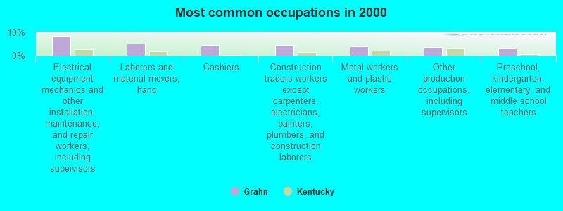
- Electrical equipment mechanics and other installation, maintenance, and repair workers, including supervisors (8.6%)
- Laborers and material movers, hand (5.0%)
- Cashiers (4.7%)
- Construction traders workers except carpenters, electricians, painters, plumbers, and construction laborers (4.7%)
- Metal workers and plastic workers (3.9%)
- Other production occupations, including supervisors (3.5%)
- Preschool, kindergarten, elementary, and middle school teachers (3.3%)

- Electrical equipment mechanics and other installation, maintenance, and repair workers, including supervisors (11.3%)
- Construction traders workers except carpenters, electricians, painters, plumbers, and construction laborers (8.0%)
- Metal workers and plastic workers (6.7%)
- Other production occupations, including supervisors (6.1%)
- Laborers and material movers, hand (5.7%)
- Rail and water transportation workers (4.9%)
- Carpenters (4.0%)

- Cashiers (11.2%)
- Preschool, kindergarten, elementary, and middle school teachers (7.8%)
- Counselors, social workers, and other community and social service specialists (5.8%)
- Textile, apparel, and furnishings workers (5.8%)
- Food and beverage serving workers, except waiters and waitresses (5.1%)
- Secretaries and administrative assistants (4.9%)
- Electrical equipment mechanics and other installation, maintenance, and repair workers, including supervisors (4.7%)
Average climate in Grahn, Kentucky
Based on data reported by over 4,000 weather stations


(lower is better)

Air Quality Index (AQI) level in 2023 was 69.8. This is about average.
| City: | 69.8 |
| U.S.: | 72.6 |

Ozone [ppb] level in 2023 was 33.3. This is about average. Closest monitor was 4.7 miles away from the city center.
| City: | 33.3 |
| U.S.: | 33.3 |

Particulate Matter (PM2.5) [µg/m3] level in 2022 was 6.85. This is about average. Closest monitor was 4.7 miles away from the city center.
| City: | 6.85 |
| U.S.: | 8.11 |
Tornado activity:
Grahn-area historical tornado activity is significantly below Kentucky state average. It is 43% smaller than the overall U.S. average.
On 4/23/1968, a category F5 (max. wind speeds 261-318 mph) tornado 32.3 miles away from the Grahn place center killed 7 people and injured 93 people and caused between $500,000 and $5,000,000 in damages.
On 5/10/2003, a category F3 (max. wind speeds 158-206 mph) tornado 21.5 miles away from the place center injured 17 people and caused $6 million in damages.
Earthquake activity:
Grahn-area historical earthquake activity is significantly above Kentucky state average. It is 25% greater than the overall U.S. average.On 7/27/1980 at 18:52:21, a magnitude 5.2 (5.1 MB, 4.7 MS, 5.0 UK, 5.2 UK, Class: Moderate, Intensity: VI - VII) earthquake occurred 48.3 miles away from Grahn center
On 8/23/2011 at 17:51:04, a magnitude 5.8 (5.8 MW, Depth: 3.7 mi) earthquake occurred 280.0 miles away from Grahn center
On 9/7/1988 at 02:28:09, a magnitude 4.6 (4.5 MB, 4.6 LG, Class: Light, Intensity: IV - V) earthquake occurred 45.5 miles away from the city center
On 8/9/2020 at 12:07:37, a magnitude 5.1 (5.1 MW, Depth: 4.7 mi) earthquake occurred 165.0 miles away from the city center
On 4/18/2008 at 09:36:59, a magnitude 5.4 (5.1 MB, 4.8 MS, 5.4 MW, 5.2 MW) earthquake occurred 262.0 miles away from the city center
On 4/18/2008 at 09:36:59, a magnitude 5.2 (5.2 MW, Depth: 8.9 mi) earthquake occurred 262.0 miles away from Grahn center
Magnitude types: regional Lg-wave magnitude (LG), body-wave magnitude (MB), surface-wave magnitude (MS), moment magnitude (MW)
Natural disasters:
The number of natural disasters in Carter County (26) is a lot greater than the US average (15).Major Disasters (Presidential) Declared: 20
Emergencies Declared: 3
Causes of natural disasters: Floods: 18, Storms: 17, Mudslides: 9, Tornadoes: 9, Winter Storms: 6, Landslides: 5, Winds: 2, Blizzard: 1, Hurricane: 1, Snowfall: 1, Snowstorm: 1, Other: 1 (Note: some incidents may be assigned to more than one category).
Colleges/universities with over 2000 students nearest to Grahn:
- Morehead State University (about 22 miles; Morehead, KY; Full-time enrollment: 7,523)
- Ashland Community and Technical College (about 26 miles; Ashland, KY; FT enrollment: 2,482)
- Shawnee State University (about 32 miles; Portsmouth, OH; FT enrollment: 4,160)
- Marshall University (about 36 miles; Huntington, WV; FT enrollment: 11,450)
- Big Sandy Community and Technical College (about 44 miles; Prestonsburg, KY; FT enrollment: 2,660)
- Maysville Community and Technical College (about 48 miles; Maysville, KY; FT enrollment: 2,969)
- West Virginia State University (about 71 miles; Institute, WV; FT enrollment: 2,133)
Points of interest:
Notable locations in Grahn: Old Hanging Prison Wall Gardens (A), Grahn Volunteer Fire Department (B). Display/hide their locations on the map
Churches in Grahn include: Kirk Memorial Missionary Baptist Church (A), Mountain Top Chapel (B), Pine Springs Church (C), Pleasant Hill Church (D), Pleasant Valley Church (E), Ross Chapel (F). Display/hide their locations on the map
Cemeteries: Bledsoe Cemetery (1), Carroll Cemetery (2), Littleton Cemetery (3), Bailey Cemetery (4), Field Cemetery (5), Colley Cemetery (6). Display/hide their locations on the map
Lake: Rose Lake (A). Display/hide its location on the map
Streams, rivers, and creeks: Dry Fork (A), Big Run (B), Dixie Fork (C), Bowling Branch (D), Craig Creek (E), Cory Branch (F), Corn Branch (G), Trough Camp Creek (H), Clifty Creek (I). Display/hide their locations on the map
Park in Grahn: Grayson Lake State Park (1). Display/hide its location on the map
| This place: | 2.6 people |
| Kentucky: | 2.5 people |
| This place: | 74.2% |
| Whole state: | 66.9% |
| This place: | 6.2% |
| Whole state: | 6.4% |
Likely homosexual households (counted as self-reported same-sex unmarried-partner households)
- Lesbian couples: 0.2% of all households
- Gay men: 0.3% of all households
| This place: | 20.8% |
| Whole state: | 15.8% |
| This place: | 6.1% |
| Whole state: | 6.6% |
For population 15 years and over in Grahn:

- Never married: 19.5%
- Now married: 65.6%
- Separated: 2.2%
- Widowed: 6.5%
- Divorced: 8.4%
For population 25 years and over in Grahn:
- High school or higher: 59.5%
- Bachelor's degree or higher: 6.5%
- Graduate or professional degree: 3.2%
- Unemployed: 10.6%
- Mean travel time to work (commute): 34.7 minutes


| Here: | 13.9 |
| Kentucky average: | 13.8 |


Graphs represent county-level data. Detailed 2008 Election Results
Religion statistics for Grahn, KY (based on Carter County data)


| Religion | Adherents | Congregations |
|---|---|---|
| Evangelical Protestant | 6,269 | 50 |
| Mainline Protestant | 666 | 8 |
| Black Protestant | 183 | 1 |
| Other | 157 | 1 |
| Catholic | 102 | 1 |
| None | 20,343 | - |
Food Environment Statistics:
| Here: | 3.28 / 10,000 pop. |
| Kentucky: | 2.19 / 10,000 pop. |
| Carter County: | 6.56 / 10,000 pop. |
| State: | 4.36 / 10,000 pop. |
| Here: | 3.65 / 10,000 pop. |
| Kentucky: | 5.74 / 10,000 pop. |
| Carter County: | 11.4% |
| Kentucky: | 11.0% |
| Carter County: | 33.8% |
| Kentucky: | 30.0% |
| Here: | 17.9% |
| Kentucky: | 15.9% |
Strongest AM radio stations in Grahn:
- WGOH (1370 AM; 5 kW; GRAYSON, KY; Owner: CARTER COUNTY BROADCASTING CO., INC.)
- WTVN (610 AM; 50 kW; COLUMBUS, OH; Owner: CITICASTERS LICENSES, L.P.)
- WLW (700 AM; 50 kW; CINCINNATI, OH; Owner: JACOR BROADCASTING CORPORATION)
- WKYH (600 AM; 5 kW; PAINTSVILLE, KY; Owner: HIGHLANDS BROADCASTING CORPORATION)
- WVHU (800 AM; 5 kW; HUNTINGTON, WV; Owner: CAPSTAR TX LIMITED PARTNERSHIP)
- WLGC (1520 AM; daytime; 5 kW; GREENUP, KY; Owner: GREENUP COUNTY BROADCASTING, INC.)
- WOKT (1040 AM; daytime; 2 kW; CANNONSBURG, KY; Owner: BIG RIVER RADIO, INC.-KY)
- WRVC (930 AM; 5 kW; HUNTINGTON, WV; Owner: FIFTH AVENUE BROADCASTING COMPANY, INC.)
- WTCR (1420 AM; 5 kW; KENOVA, WV; Owner: CAPSTAR TX LIMITED PARTNERSHIP)
- WHAS (840 AM; 50 kW; LOUISVILLE, KY; Owner: CLEAR CHANNEL BROADCASTING LICENSES, INC.)
- WHRD (1470 AM; 5 kW; HUNTINGTON, WV; Owner: CONCORD MEDIA GROUP, INC.)
- WSAI (1530 AM; 50 kW; CINCINNATI, OH; Owner: JACOR BROADCASTING CORPORATION)
- WNXT (1260 AM; 5 kW; PORTSMOUTH, OH; Owner: HOMETOWN B/C OF PORTSMOUTH, INC.)
Strongest FM radio stations in Grahn:
- WUGO (102.3 FM; GRAYSON, KY; Owner: CARTER COUNTY BROADCASTING CO., INC.)
- WMKY (90.3 FM; MOREHEAD, KY; Owner: MOREHEAD STATE UNIVERSITY)
- WPAY-FM (104.1 FM; PORTSMOUTH, OH; Owner: RADIO STATIONS WPAY/WPFB, INC.)
- WDGG (93.7 FM; ASHLAND, KY; Owner: FIFTH AVENUE B/CASTING COMPANY, INC.)
- WOSP (91.5 FM; PORTSMOUTH, OH; Owner: THE OHIO STATE UNIVERSITY)
- WBMK (88.5 FM; MOREHEAD, KY; Owner: AMERICAN FAMILY ASSOCIATION)
- WBKS (107.1 FM; IRONTON, OH; Owner: CAPSTAR TX LIMITED PARTNERSHIP)
- WOKE (98.3 FM; GARRISON, KY; Owner: BIG RIVER RADIO, INC.)
- WLGC-FM (105.7 FM; GREENUP, KY; Owner: GREENUP COUNTY BROADCASTING, INC.)
- WOHP (88.3 FM; PORTSMOUTH, OH; Owner: THE CEDARVILLE UNIVERSITY)
- WQHY (95.5 FM; PRESTONSBURG, KY; Owner: WDOC, INC.)
- WBVB (97.1 FM; COAL GROVE, OH; Owner: CAPSTAR TX LIMITED PARTNERSHIP)
- WRVC-FM (92.7 FM; CATLETTSBURG, KY; Owner: FIFTH AVENUE BROADCASTING CO., INC)
- WKLW-FM (94.7 FM; PAINTSVILLE, KY; Owner: B & G BROADCASTING, INC.)
- WFLE-FM (95.1 FM; FLEMINGSBURG, KY; Owner: FLEMING COUNTY BROADCASTING CO., INC)
- WNXT-FM (99.3 FM; PORTSMOUTH, OH; Owner: HOMETOWN B/C OF PORTSMOUTH, INC.)
- WQXX (106.1 FM; MOREHEAD, KY; Owner: MORGAN COUNTY INDUSTRIES, INC.)
- W215AV (90.9 FM; SOUTH PORTSMOUTH, KY; Owner: CALVARY CHAPEL OF TWIN FALLS, INC.)
- WKEE-FM (100.5 FM; HUNTINGTON, WV; Owner: CAPSTAR TX LIMITED PARTNERSHIP)
- WZAQ (92.3 FM; LOUISA, KY; Owner: LOUISA COMMUNICATIONS, INC.)
TV broadcast stations around Grahn:
- WKMR (Channel 38; MOREHEAD, KY; Owner: KENTUCKY AUTHORITY FOR EDUCATIONAL TV)
- WUPX-TV (Channel 67; MOREHEAD, KY; Owner: PAXSON LEXINGTON LICENSE, INC.)
- WPBO (Channel 42; PORTSMOUTH, OH; Owner: THE OHIO STATE UNIVERSITY)
- WPBY-TV (Channel 33; HUNTINGTON, WV; Owner: WEST VIRGINIA EDUCATIONAL BROADCASTING AUTHORITY)
- WHCP (Channel 30; PORTSMOUTH, OH; Owner: TELEVISION PROPERTIES, INC.)
- WKAS (Channel 25; ASHLAND, KY; Owner: KENTUCKY AUTHORITY FOR EDUCATIONAL TV)

Grahn fatal accident list:
May 28, 1988 08:40 PM, 182, Vehicles: 2, Persons: 4, Fatalities: 1, Drunk persons involved: 1
FCC Registered Broadcast Land Mobile Towers:
1- 2200 W Of Fire Station On Rt 182 (Lat: 38.287861 Lon: -83.092944), Call Sign: WRD897,
Assigned Frequencies: 154.145 MHz, Grant Date: 07/13/1999, Expiration Date: 09/20/2004, Cancellation Date: 11/20/2004, Registrant: Grahn Volunteer Fire Department, Box 81, Grahn, KY 41142, Phone: (606) 286-6233
FCC Registered Microwave Towers:
1- GRAHN, On Biggs Hill 3.7 Mi N Of (Lat: 38.337278 Lon: -83.081833), Overall height: 45.7 m, Call Sign: WHC251,
Assigned Frequencies: 1900.00 MHz, Grant Date: 08/19/1999, Expiration Date: 03/05/2002, Cancellation Date: 03/05/2002, Phone: (202) 434-4130

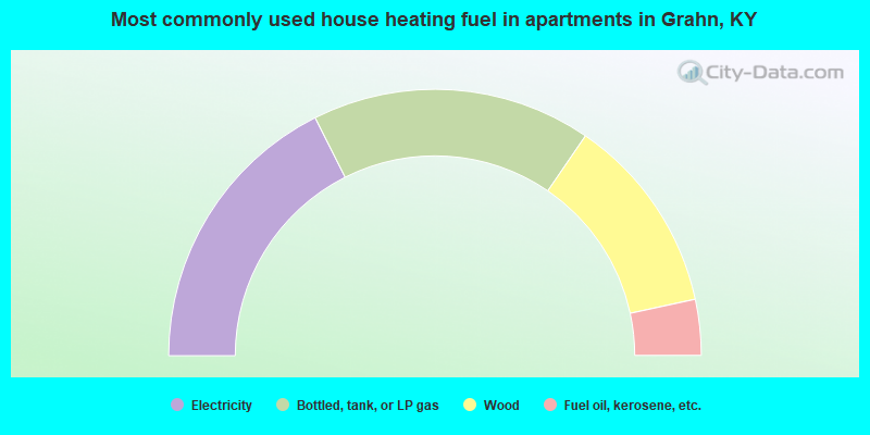
- 40.2%Electricity
- 30.4%Bottled, tank, or LP gas
- 21.2%Wood
- 6.1%Fuel oil, kerosene, etc.
- 1.4%Coal or coke
- 0.7%Other fuel
- 35.2%Electricity
- 34.0%Bottled, tank, or LP gas
- 24.1%Wood
- 6.8%Fuel oil, kerosene, etc.
Grahn compared to Kentucky state average:
- Median house value below state average.
- Black race population percentage significantly below state average.
- Hispanic race population percentage significantly below state average.
- Foreign-born population percentage significantly below state average.
- Renting percentage below state average.
- Length of stay since moving in significantly above state average.
- Number of rooms per house significantly below state average.
- House age significantly below state average.
- Number of college students below state average.
- Percentage of population with a bachelor's degree or higher significantly below state average.