Fullerton, Kentucky
Submit your own pictures of this place and show them to the world
- OSM Map
- General Map
- Google Map
- MSN Map

| Males: 1,550 | |
| Females: 1,820 |
| Median resident age: | 39.7 years |
| Kentucky median age: | 35.9 years |
Zip code: 41175
| Fullerton: | $42,783 |
| KY: | $59,341 |
Estimated per capita income in 2022: $26,961 (it was $14,210 in 2000)
Fullerton CCD income, earnings, and wages data
Estimated median house or condo value in 2022: $115,647 (it was $47,800 in 2000)
| Fullerton: | $115,647 |
| KY: | $196,300 |
Mean prices in 2022: all housing units: $191,732; detached houses: $206,522; townhouses or other attached units: $627,757; in 2-unit structures: $20,333; mobile homes: $66,744
Detailed information about poverty and poor residents in Fullerton, KY


- 3,24097.9%White alone
- 421.3%Two or more races
- 170.5%American Indian alone
- 70.2%Hispanic
- 20.06%Black alone
- 10.03%Asian alone
- 10.03%Other race alone

Races in Fullerton detailed stats: ancestries, foreign born residents, place of birth
 Recent articles from our blog. Our writers, many of them Ph.D. graduates or candidates, create easy-to-read articles on a wide variety of topics.
Current Local Time: EST time zone
Elevation: 650 feet
Land area: 12.3 square miles.
Population density: 273 people per square mile (very low).

| Fullerton CCD: | 0.9% ($426) |
| Kentucky: | 0.8% ($610) |
Nearest city with pop. 50,000+: Huntington, WV  (36.0 miles , pop. 51,475).
Nearest city with pop. 200,000+: Cincinnati, OH (87.3 miles , pop. 331,285).
Nearest city with pop. 1,000,000+: Chicago, IL (329.0 miles , pop. 2,896,016).
Nearest cities:
), ), ), ), ), )Latitude: 38.72 N, Longitude: 82.97 W


| Here: | 6.3% |
| Kentucky: | 3.8% |

- Health care (18.1%)
- Educational services (7.2%)
- Construction (6.9%)
- Accommodation & food services (5.5%)
- Nonmetallic mineral products (5.0%)
- Furniture & related product manufacturing (4.2%)
- Food & beverage stores (3.6%)

- Construction (13.3%)
- Nonmetallic mineral products (9.3%)
- Health care (7.2%)
- Educational services (6.7%)
- Furniture & related product manufacturing (5.0%)
- Rail transportation (5.0%)
- Other transportation, support activities, couriers (3.3%)

- Health care (30.1%)
- Accommodation & food services (8.3%)
- Educational services (7.8%)
- Food & beverage stores (6.7%)
- Building material & garden equipment & supplies dealers (4.5%)
- Finance & insurance (4.4%)
- Social assistance (4.2%)

- Other production occupations, including supervisors (6.2%)
- Cashiers (5.6%)
- Material recording, scheduling, dispatching, and distributing workers (4.3%)
- Other office and administrative support workers, including supervisors (3.6%)
- Laborers and material movers, hand (3.5%)
- Driver/sales workers and truck drivers (3.4%)
- Registered nurses (3.3%)

- Other production occupations, including supervisors (8.2%)
- Driver/sales workers and truck drivers (6.0%)
- Carpenters (5.7%)
- Material recording, scheduling, dispatching, and distributing workers (5.2%)
- Laborers and material movers, hand (4.7%)
- Vehicle and mobile equipment mechanics, installers, and repairers (4.0%)
- Health technologists and technicians (4.0%)

- Cashiers (11.3%)
- Registered nurses (6.9%)
- Other office and administrative support workers, including supervisors (6.2%)
- Preschool, kindergarten, elementary, and middle school teachers (4.9%)
- Financial clerks, except bookkeeping, accounting and auditing clerks (4.5%)
- Other production occupations, including supervisors (4.0%)
- Nursing, psychiatric, and home health aides (3.8%)
Average climate in Fullerton, Kentucky
Based on data reported by over 4,000 weather stations


(lower is better)

Air Quality Index (AQI) level in 2023 was 90.7. This is worse than average.
| City: | 90.7 |
| U.S.: | 72.6 |

Sulfur Dioxide (SO2) [ppb] level in 2023 was 0.576. This is significantly better than average. Closest monitor was 0.3 miles away from the city center.
| City: | 0.576 |
| U.S.: | 1.515 |

Ozone [ppb] level in 2022 was 25.6. This is better than average. Closest monitor was 17.6 miles away from the city center.
| City: | 25.6 |
| U.S.: | 33.3 |


Particulate Matter (PM2.5) [µg/m3] level in 2023 was 10.8. This is worse than average. Closest monitor was 3.8 miles away from the city center.
| City: | 10.8 |
| U.S.: | 8.1 |
Tornado activity:
Fullerton-area historical tornado activity is below Kentucky state average. It is 27% smaller than the overall U.S. average.
On 4/23/1968, a category F5 (max. wind speeds 261-318 mph) tornado 9.3 miles away from the Fullerton place center killed 7 people and injured 93 people and caused between $500,000 and $5,000,000 in damages.
On 4/23/1968, a category F4 (max. wind speeds 207-260 mph) tornado 11.4 miles away from the place center killed 6 people and injured 364 people and caused between $5,000,000 and $50,000,000 in damages.
Earthquake activity:
Fullerton-area historical earthquake activity is significantly above Kentucky state average. It is 16% greater than the overall U.S. average.On 7/27/1980 at 18:52:21, a magnitude 5.2 (5.1 MB, 4.7 MS, 5.0 UK, 5.2 UK, Class: Moderate, Intensity: VI - VII) earthquake occurred 63.6 miles away from the city center
On 8/23/2011 at 17:51:04, a magnitude 5.8 (5.8 MW, Depth: 3.7 mi) earthquake occurred 278.9 miles away from the city center
On 9/7/1988 at 02:28:09, a magnitude 4.6 (4.5 MB, 4.6 LG, Class: Light, Intensity: IV - V) earthquake occurred 63.3 miles away from Fullerton center
On 8/9/2020 at 12:07:37, a magnitude 5.1 (5.1 MW, Depth: 4.7 mi) earthquake occurred 186.2 miles away from the city center
On 4/18/2008 at 09:36:59, a magnitude 5.4 (5.1 MB, 4.8 MS, 5.4 MW, 5.2 MW) earthquake occurred 266.4 miles away from Fullerton center
On 9/25/1998 at 19:52:52, a magnitude 5.2 (4.8 MB, 4.3 MS, 5.2 LG, 4.5 MW, Depth: 3.1 mi) earthquake occurred 235.1 miles away from Fullerton center
Magnitude types: regional Lg-wave magnitude (LG), body-wave magnitude (MB), surface-wave magnitude (MS), moment magnitude (MW)
Natural disasters:
The number of natural disasters in Greenup County (22) is greater than the US average (15).Major Disasters (Presidential) Declared: 16
Emergencies Declared: 3
Causes of natural disasters: Floods: 14, Storms: 13, Tornadoes: 7, Winter Storms: 6, Mudslides: 5, Landslides: 3, Blizzard: 1, Hurricane: 1, Snowfall: 1, Snowstorm: 1, Wind: 1, Other: 1 (Note: some incidents may be assigned to more than one category).
Hospitals and medical centers near Fullerton:
- BRIDGEPORT HEALTH CARE CENTER (Nursing Home, about 1 miles away; PORTSMOUTH, OH)
- HOME CARE NETWORK, INC (Home Health Center, about 2 miles away; PORTSMOUTH, OH)
- FMC - PORTSMOUTH (Dialysis Facility, about 2 miles away; PORTSMOUTH, OH)
- CHRISANNA HEALTH CARE (Nursing Home, about 2 miles away; PORTSMOUTH, OH)
- CRYSTAL CARE CTR OF PORTSMOUTH (Nursing Home, about 2 miles away; PORTSMOUTH, OH)
- SKILLED NURSING INC (Home Health Center, about 2 miles away; PORTSMOUTH, OH)
- HALLMARK CARE CENTER INC (Nursing Home, about 2 miles away; PORTSMOUTH, OH)
Colleges/universities with over 2000 students nearest to Fullerton:
- Shawnee State University (about 2 miles; Portsmouth, OH; Full-time enrollment: 4,160)
- Ashland Community and Technical College (about 25 miles; Ashland, KY; FT enrollment: 2,482)
- Marshall University (about 36 miles; Huntington, WV; FT enrollment: 11,450)
- Morehead State University (about 45 miles; Morehead, KY; FT enrollment: 7,523)
- Maysville Community and Technical College (about 46 miles; Maysville, KY; FT enrollment: 2,969)
- Southern State Community College (about 50 miles; Hillsboro, OH; FT enrollment: 2,418)
- Ohio Christian University (about 62 miles; Circleville, OH; FT enrollment: 2,345)
Points of interest:
Notable location: South Shore Volunteer Fire Protection District (A). Display/hide its location on the map
Churches in Fullerton include: White Oak Chapel (A), Valley Church (B). Display/hide their locations on the map
Cemetery: Collier Memorial Garden (1). Display/hide its location on the map
Lake: Horseshoe Lake (A). Display/hide its location on the map
Streams, rivers, and creeks: Tygarts Creek (A), Lick Branch (B), Rock Creek (C). Display/hide their locations on the map
Park in Fullerton: Legion Park (1). Display/hide its location on the map
| This place: | 2.4 people |
| Kentucky: | 2.5 people |
| This place: | 53.2% |
| Whole state: | 69.8% |
| This place: | 3.3% |
| Whole state: | 4.5% |
Likely homosexual households (counted as self-reported same-sex unmarried-partner households)
- Lesbian couples: 0.3% of all households
- Gay men: 0.2% of all households
| This place: | 18.0% |
| Whole state: | 15.8% |
| This place: | 3.9% |
| Whole state: | 6.6% |
For population 15 years and over in Fullerton:

- Never married: 15.1%
- Now married: 63.4%
- Separated: 1.2%
- Widowed: 10.6%
- Divorced: 10.8%
For population 25 years and over in Fullerton:
- High school or higher: 72.6%
- Bachelor's degree or higher: 6.9%
- Graduate or professional degree: 3.9%
- Unemployed: 9.4%
- Mean travel time to work (commute): 29.2 minutes


| Here: | 12.1 |
| Kentucky average: | 13.8 |
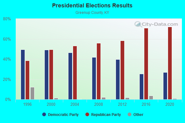

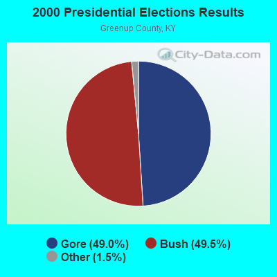
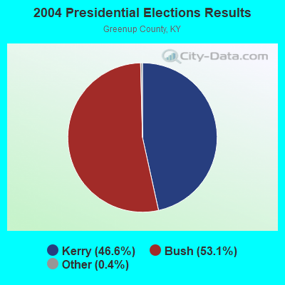
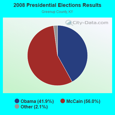
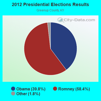
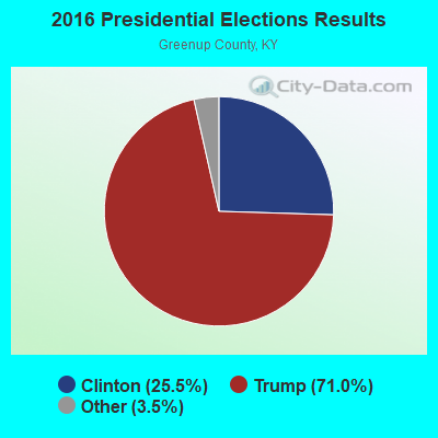
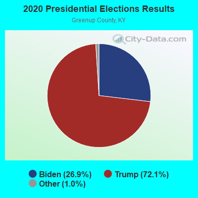
Graphs represent county-level data. Detailed 2008 Election Results
Religion statistics for Fullerton, KY (based on Greenup County data)
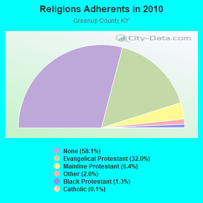
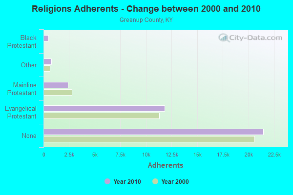
| Religion | Adherents | Congregations |
|---|---|---|
| Evangelical Protestant | 11,804 | 61 |
| Mainline Protestant | 2,368 | 15 |
| Other | 751 | 2 |
| Black Protestant | 483 | 3 |
| Catholic | 43 | 1 |
| None | 21,461 | - |
Food Environment Statistics:
| Here: | 2.15 / 10,000 pop. |
| Kentucky: | 2.19 / 10,000 pop. |
| Greenup County: | 0.54 / 10,000 pop. |
| Kentucky: | 0.74 / 10,000 pop. |
| Here: | 5.10 / 10,000 pop. |
| Kentucky: | 4.36 / 10,000 pop. |
| Greenup County: | 1.07 / 10,000 pop. |
| Kentucky: | 5.74 / 10,000 pop. |
| Greenup County: | 13.0% |
| Kentucky: | 11.0% |
| This county: | 31.9% |
| State: | 30.0% |
| This county: | 17.7% |
| State: | 15.9% |
Strongest AM radio stations in Fullerton:
- WIOI (1010 AM; 1 kW; NEW BOSTON, OH)
- WPAY (1400 AM; 1 kW; PORTSMOUTH, OH; Owner: RADIO STATIONS WPAY/WPFB, INC.)
- WNXT (1260 AM; 5 kW; PORTSMOUTH, OH; Owner: HOMETOWN B/C OF PORTSMOUTH, INC.)
- WLGC (1520 AM; daytime; 5 kW; GREENUP, KY; Owner: GREENUP COUNTY BROADCASTING, INC.)
- WTVN (610 AM; 50 kW; COLUMBUS, OH; Owner: CITICASTERS LICENSES, L.P.)
- WLW (700 AM; 50 kW; CINCINNATI, OH; Owner: JACOR BROADCASTING CORPORATION)
- WGOH (1370 AM; 5 kW; GRAYSON, KY; Owner: CARTER COUNTY BROADCASTING CO., INC.)
- WVHU (800 AM; 5 kW; HUNTINGTON, WV; Owner: CAPSTAR TX LIMITED PARTNERSHIP)
- WRVC (930 AM; 5 kW; HUNTINGTON, WV; Owner: FIFTH AVENUE BROADCASTING COMPANY, INC.)
- WBGS (1030 AM; daytime; 10 kW; POINT PLEASANT, WV; Owner: BIG RIVER RADIO, INC.)
- WTCR (1420 AM; 5 kW; KENOVA, WV; Owner: CAPSTAR TX LIMITED PARTNERSHIP)
- WSAI (1530 AM; 50 kW; CINCINNATI, OH; Owner: JACOR BROADCASTING CORPORATION)
- WRFD (880 AM; daytime; 23 kW; COLUMBUS-WORTHINGTON, OH; Owner: SALEM MEDIA OF OHIO, INC.)
Strongest FM radio stations in Fullerton:
- WPAY-FM (104.1 FM; PORTSMOUTH, OH; Owner: RADIO STATIONS WPAY/WPFB, INC.)
- WOHP (88.3 FM; PORTSMOUTH, OH; Owner: THE CEDARVILLE UNIVERSITY)
- WNXT-FM (99.3 FM; PORTSMOUTH, OH; Owner: HOMETOWN B/C OF PORTSMOUTH, INC.)
- W215AV (90.9 FM; SOUTH PORTSMOUTH, KY; Owner: CALVARY CHAPEL OF TWIN FALLS, INC.)
- WZZZ (107.5 FM; PORTSMOUTH, OH; Owner: HOMETOWN BROADCASTING OF PORTSMOUTH 2, INC.)
- WOSP (91.5 FM; PORTSMOUTH, OH; Owner: THE OHIO STATE UNIVERSITY)
- WOKE (98.3 FM; GARRISON, KY; Owner: BIG RIVER RADIO, INC.)
- WLGC-FM (105.7 FM; GREENUP, KY; Owner: GREENUP COUNTY BROADCASTING, INC.)
- WBKS (107.1 FM; IRONTON, OH; Owner: CAPSTAR TX LIMITED PARTNERSHIP)
- WRAU (94.9 FM; SOUTH WEBSTER, OH; Owner: IM-MEDIA BROADCASTING, INC.)
- WDGG (93.7 FM; ASHLAND, KY; Owner: FIFTH AVENUE B/CASTING COMPANY, INC.)
- W214BI (90.7 FM; PIKETON, OH; Owner: THE CEDARVILLE UNIVERSITY)
- WBVB (97.1 FM; COAL GROVE, OH; Owner: CAPSTAR TX LIMITED PARTNERSHIP)
- WVWV (89.9 FM; HUNTINGTON, WV; Owner: WEST VIRGINIA EDUCATIONAL BROADCASTING AUTHORITY)
- WAMX (106.3 FM; MILTON, WV; Owner: CAPSTAR TX LIMITED PARTNERSHIP)
- WOUL-FM (89.1 FM; IRONTON, OH; Owner: OHIO UNIVERSITY)
- WRVC-FM (92.7 FM; CATLETTSBURG, KY; Owner: FIFTH AVENUE BROADCASTING CO., INC)
- WKKS-FM (104.9 FM; VANCEBURG, KY; Owner: BROWN COMMUNICATIONS, INC.)
TV broadcast stations around Fullerton:
- W66CZ (Channel 66; PORTSMOUTH, OH; Owner: TRINITY BROADCASTING NETWORK)
- WPBO (Channel 42; PORTSMOUTH, OH; Owner: THE OHIO STATE UNIVERSITY)
- WHCP (Channel 30; PORTSMOUTH, OH; Owner: TELEVISION PROPERTIES, INC.)
- WPBY-TV (Channel 33; HUNTINGTON, WV; Owner: WEST VIRGINIA EDUCATIONAL BROADCASTING AUTHORITY)
- WSAZ-TV (Channel 3; HUNTINGTON, WV; Owner: EMMIS TELEVISION LICENSE CORPORATION)
- WOWK-TV (Channel 13; HUNTINGTON, WV; Owner: WEST VIRGINIA MEDIA HOLDINGS, LLC)
- WKAS (Channel 25; ASHLAND, KY; Owner: KENTUCKY AUTHORITY FOR EDUCATIONAL TV)
FCC Registered Commercial Land Mobile Towers:
1- Lat: 36.722861 Lon: -83.001278, Call Sign: KRF583,
Assigned Frequencies: 26.1900 MHz, Grant Date: 01/21/1970, Expiration Date: 10/01/1970, Cancellation Date: 09/24/2000, Registrant: T R Inc

- 60.2%Utility gas
- 25.6%Electricity
- 11.4%Bottled, tank, or LP gas
- 1.3%Wood
- 1.2%Fuel oil, kerosene, etc.
- 0.3%Other fuel

- 46.5%Utility gas
- 46.5%Electricity
- 3.1%Solar energy
- 2.9%Fuel oil, kerosene, etc.
- 1.0%Bottled, tank, or LP gas
Fullerton compared to Kentucky state average:
- Median house value below state average.
- Black race population percentage significantly below state average.
- Hispanic race population percentage significantly below state average.
- Foreign-born population percentage significantly below state average.
- Renting percentage significantly below state average.
- Length of stay since moving in significantly above state average.
- Number of rooms per house significantly below state average.
- House age significantly below state average.
- Institutionalized population percentage significantly above state average.
- Percentage of population with a bachelor's degree or higher significantly below state average.