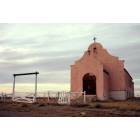
Fort Belknap, Montana
Submit your own pictures of this place and show them to the world
- OSM Map
- General Map
- Google Map
- MSN Map

| Males: 1,283 | |
| Females: 1,325 |
| Median resident age: | 22.9 years |
| Montana median age: | 37.5 years |
Zip code: 59524
| Fort Belknap: | $49,970 |
| MT: | $67,631 |
Estimated per capita income in 2022: $16,562 (it was $8,124 in 2000)
Fort Belknap CCD income, earnings, and wages data
Estimated median house or condo value in 2022: $132,180 (it was $50,800 in 2000)
| Fort Belknap: | $132,180 |
| MT: | $366,400 |
Mean prices in 2022: all housing units: $197,996; detached houses: $207,294; townhouses or other attached units: $116,291; mobile homes: $128,232
Detailed information about poverty and poor residents in Fort Belknap, MT
Compare current foreclosures near your location:
| Photo | Address | Area | Beds / Baths | Price | Details |
|---|---|---|---|---|---|

|
#1
Bayberry Cir
Columbus, OH 43207
|
1,564 sq. feet
|
1 baths 3 beds |
$127,500
|
show details |

|
#2
S High St
Columbus, OH 43207
|
1,678 sq. feet
|
2 baths 4 beds |
$31,900
|
show details |

|
#3
E 21st Ave
Columbus, OH 43211
|
1,061 sq. feet
|
1 baths 3 beds |
$179,900
|
show details |

|
#4
Roundelay Rd N
Reynoldsburg, OH 43068
|
1,712 sq. feet
|
2 baths 3 beds |
show details | |

|
#5
E Howard Rd
Columbus, OH 43207
|
1,056 sq. feet
|
1 baths 3 beds |
show details | |

|
#6
London Groveport Rd
Grove City, OH 43123
|
816 sq. feet
|
1 baths 2 beds |
show details | |

|
#7
Chidley St
Galloway, OH 43119
|
1,502 sq. feet
|
1 baths 3 beds |
show details | |

|
#8
Summertree Ln
Westerville, OH 43081
|
2,496 sq. feet
|
2 baths 3 beds |
show details | |

|
#9
E Lincoln Ave
Columbus, OH 43214
|
874 sq. feet
|
1 baths 3 beds |
show details | |

|
#10
Fergus Rd
Grove City, OH 43123
|
3,312 sq. feet
|
2 baths 4 beds |
show details |
| Photo | Address | Area | Beds / Baths | Price | Details |
|---|---|---|---|---|---|

|
#11
Rosewood Ct
Powell, OH 43065
|
2,801 sq. feet
|
3 baths 4 beds |
show details | |

|
#12
Armada Rd
Columbus, OH 43232
|
1,028 sq. feet
|
1 baths 4 beds |
show details | |

|
#13
N Roys Ave
Columbus, OH 43204
|
1,248 sq. feet
|
2 baths 3 beds |
show details | |

|
#14
N Roys Ave
Columbus, OH 43204
|
648 sq. feet
|
2 baths 3 beds |
show details | |

|
#15
S Richardson Ave
Columbus, OH 43204
|
1,520 sq. feet
|
2 baths 3 beds |
show details | |

|
#16
Meadowbrook Dr
Columbus, OH 43207
|
1,752 sq. feet
|
2 baths 4 beds |
show details | |

|
#17
Executive Ct
Westerville, OH 43081
|
1,811 sq. feet
|
2 baths 3 beds |
show details | |

|
#18
High Free Pike
West Jefferson, OH 43162
|
1,216 sq. feet
|
2 baths 4 beds |
show details | |

|
#19
Falls Peak Ln
Delaware, OH 43015
|
1,352 sq. feet
|
2 baths 2 beds |
show details | |

|
#20
Ashgrove Dr
Grove City, OH 43123
|
1,772 sq. feet
|
2 baths 4 beds |
show details |
| Photo | Address | Area | Beds / Baths | Price | Details |
|---|---|---|---|---|---|

|
#21
Lehner Rd
Columbus, OH 43224
|
1,628 sq. feet
|
2 baths 4 beds |
show details | |

|
#22
Grasmere Ave
Columbus, OH 43211
|
720 sq. feet
|
1 baths 2 beds |
show details | |

|
#23
E Welch Ave
Columbus, OH 43207
|
1,864 sq. feet
|
2 baths 4 beds |
show details | |

|
#24
Wrexham Ave
Columbus, OH 43223
|
1,235 sq. feet
|
1 baths 3 beds |
show details | |

|
#25
Kelton Ave
Columbus, OH 43206
|
1,080 sq. feet
|
1 baths 3 beds |
show details | |

|
#26
Hamilton Ave
Columbus, OH 43211
|
1,061 sq. feet
|
1 baths 3 beds |
show details | |

|
#27
Striebel Ct
Columbus, OH 43227
|
925 sq. feet
|
1 baths 3 beds |
show details | |

|
#28
S Champion Ave
Columbus, OH 43207
|
1,157 sq. feet
|
1 baths 2 beds |
show details | |

|
#29
Fairfield Ave
Columbus, OH 43203
|
984 sq. feet
|
1 baths 2 beds |
show details | |

|
#30
N 18th St
Columbus, OH 43203
|
1,690 sq. feet
|
1 baths 4 beds |
show details |
| Photo | Address | Area | Beds / Baths | Price | Details |
|---|---|---|---|---|---|

|
#31
Cannonade Ct
Columbus, OH 43230
|
2,023 sq. feet
|
2 baths 3 beds |
show details | |

|
#32
Glenmate Ct
Columbus, OH 43223
|
1,050 sq. feet
|
1 baths 3 beds |
show details | |

|
#33
Safford Ave
Columbus, OH 43223
|
784 sq. feet
|
1 baths 2 beds |
show details | |

|
#34
Chester Rd
Columbus, OH 43221
|
3,300 sq. feet
|
4 baths 5 beds |
show details | |

|
#35
Upton Rd E
Columbus, OH 43232
|
852 sq. feet
|
1 baths 3 beds |
show details | |

|
#36
Whittman Ct
Plain City, OH 43064
|
3,186 sq. feet
|
3 baths 4 beds |
show details | |

|
#37
Hildreth Ave
Columbus, OH 43203
|
1,798 sq. feet
|
2 baths 4 beds |
show details | |

|
#38
Gladys Rd
Columbus, OH 43228
|
832 sq. feet
|
1 baths 3 beds |
show details | |

|
#39
Mccutcheon Rd
Columbus, OH 43219
|
2,130 sq. feet
|
2 baths 3 beds |
show details | |

|
#40
Hedgerow Rd
Columbus, OH 43220
|
1,102 sq. feet
|
2 baths 2 beds |
show details |
| Photo | Address | Area | Beds / Baths | Price | Details |
|---|---|---|---|---|---|

|
#41
Stephen St
Grove City, OH 43123
|
1,027 sq. feet
|
1 baths 3 beds |
show details | |

|
#42
Messner Dr
Hilliard, OH 43026
|
832 sq. feet
|
1 baths 2 beds |
show details | |

|
#43
Falene Pl
Galloway, OH 43119
|
1,178 sq. feet
|
1 baths 3 beds |
show details | |

|
#44
Autumn Wind Dr
Grove City, OH 43123
|
1,697 sq. feet
|
2 baths 3 beds |
show details | |

|
#45
Wesson Dr
Columbus, OH 43232
|
1,200 sq. feet
|
1 baths 3 beds |
show details | |

|
#46
Stoneybrook B 21a
Hilliard, OH 43026
|
1,031 sq. feet
|
1 baths 3 beds |
show details | |

|
#47
Almont Dr
Columbus, OH 43229
|
1,563 sq. feet
|
2 baths 5 beds |
show details | |

|
#48
Windy Hill Ln
Galloway, OH 43119
|
1,350 sq. feet
|
2 baths 3 beds |
show details | |

|
#49
Conway Dr
Columbus, OH 43227
|
1,225 sq. feet
|
1 baths 3 beds |
show details | |

|
Check over 1 million property listings on Foreclosure.com!
|
browse all offers | |||

- 2,63093.9%American Indian alone
- 1174.2%White alone
- 311.1%Hispanic
- 180.6%Two or more races
- 20.07%Black alone
- 20.07%Native Hawaiian and Other
Pacific Islander alone - 10.04%Asian alone

Races in Fort Belknap detailed stats: ancestries, foreign born residents, place of birth
 Recent articles from our blog. Our writers, many of them Ph.D. graduates or candidates, create easy-to-read articles on a wide variety of topics.
Current Local Time: MST time zone
Land area: 889.9 square miles.
Population density: 2.9 people per square mile (very low).

| Fort Belknap CCD: | 1.9% ($987) |
| Montana: | 1.3% ($1,212) |
Nearest city with pop. 50,000+: Great Falls, MT  (124.1 miles , pop. 56,690).
Nearest city with pop. 200,000+: West Adams, CO (604.4 miles , pop. 259,628).
Nearest city with pop. 1,000,000+: Phoenix, AZ (1027.1 miles , pop. 1,321,045).
Nearest cities:
), ), )Latitude: 48.17 N, Longitude: 108.81 W
Area code commonly used in this area: 406


| Here: | 4.4% |
| Montana: | 3.8% |

- Public administration (22.4%)
- Educational services (17.8%)
- Health care (13.4%)
- Social assistance (9.6%)
- Construction (8.3%)
- Agriculture, forestry, fishing & hunting (7.4%)
- Food & beverage stores (4.9%)

- Public administration (19.1%)
- Educational services (16.8%)
- Construction (16.0%)
- Agriculture, forestry, fishing & hunting (11.7%)
- Health care (7.9%)
- Real estate & rental & leasing (5.1%)
- Food & beverage stores (4.8%)

- Public administration (25.7%)
- Educational services (18.8%)
- Health care (18.8%)
- Social assistance (15.3%)
- Food & beverage stores (4.9%)
- Agriculture, forestry, fishing & hunting (3.2%)
- Accommodation & food services (3.2%)

- Other management occupations, except farmers and farm managers (6.4%)
- Secretaries and administrative assistants (6.1%)
- Preschool, kindergarten, elementary, and middle school teachers (4.6%)
- Building and grounds cleaning and maintenance occupations (4.4%)
- Information and record clerks, except customer service representatives (3.9%)
- Other office and administrative support workers, including supervisors (3.6%)
- Other teachers, instructors, education, training, and library occupations (3.4%)

- Building and grounds cleaning and maintenance occupations (7.1%)
- Carpenters (6.6%)
- Farmers and farm managers (6.1%)
- Vehicle and mobile equipment mechanics, installers, and repairers (5.3%)
- Other management occupations, except farmers and farm managers (5.1%)
- Law enforcement workers, including supervisors (4.1%)
- Laborers and material movers, hand (3.8%)

- Secretaries and administrative assistants (11.1%)
- Other management occupations, except farmers and farm managers (7.7%)
- Information and record clerks, except customer service representatives (6.9%)
- Other office and administrative support workers, including supervisors (6.7%)
- Preschool, kindergarten, elementary, and middle school teachers (6.4%)
- Counselors, social workers, and other community and social service specialists (5.4%)
- Other teachers, instructors, education, training, and library occupations (5.4%)
Average climate in Fort Belknap, Montana
Based on data reported by over 4,000 weather stations


Earthquake activity:
Fort Belknap-area historical earthquake activity is significantly above Montana state average. It is 410% greater than the overall U.S. average.On 8/18/1959 at 06:37:13, a magnitude 7.7 (7.7 UK, Class: Major, Intensity: VIII - XII) earthquake occurred 264.7 miles away from Fort Belknap center, causing $26,000,000 total damage
On 10/28/1983 at 14:06:06, a magnitude 7.3 (6.2 MB, 7.3 MS, 7.0 MW) earthquake occurred 370.9 miles away from Fort Belknap center, causing 2 deaths (2 shaking deaths) and 3 injuries, causing $15,000,000 total damage
On 7/6/2017 at 06:30:17, a magnitude 5.8 (5.8 MW, Depth: 7.6 mi, Class: Moderate, Intensity: VI - VII) earthquake occurred 197.4 miles away from Fort Belknap center
On 6/30/1975 at 18:54:13, a magnitude 6.1 (5.6 MB, 5.9 MS, 6.1 UK, 6.1 ML, Class: Strong, Intensity: VII - IX) earthquake occurred 259.1 miles away from the city center
On 3/31/2020 at 23:52:30, a magnitude 6.5 (6.5 MW, Depth: 7.5 mi) earthquake occurred 395.6 miles away from Fort Belknap center
On 7/26/2005 at 04:08:37, a magnitude 5.7 (5.7 MB, 5.2 MS, 5.6 MW) earthquake occurred 262.1 miles away from Fort Belknap center
Magnitude types: body-wave magnitude (MB), local magnitude (ML), surface-wave magnitude (MS), moment magnitude (MW)
Natural disasters:
The number of natural disasters in Blaine County (9) is smaller than the US average (15).Major Disasters (Presidential) Declared: 6
Emergencies Declared: 1
Causes of natural disasters: Floods: 6, Storms: 3, Fire: 1, Hurricane: 1, Wind: 1, Other: 1 (Note: some incidents may be assigned to more than one category).
Colleges/universities with over 2000 students nearest to Fort Belknap:
- Montana State University-Billings (about 166 miles; Billings, MT; Full-time enrollment: 4,319)
- Montana State University (about 204 miles; Bozeman, MT; FT enrollment: 12,942)
- Sheridan College (about 253 miles; Sheridan, WY; FT enrollment: 2,070)
- The University of Montana (about 259 miles; Missoula, MT; FT enrollment: 13,602)
- Brigham Young University-Idaho (about 334 miles; Rexburg, ID; FT enrollment: 30,522)
- Minot State University (about 346 miles; Minot, ND; FT enrollment: 2,887)
- Black Hills State University (about 347 miles; Spearfish, SD; FT enrollment: 3,166)
Points of interest:
Notable locations in Fort Belknap: Fort Belknap Rest Area (A), Fort Belknap Youth Camp (B), Fort Belknap Volunteer Fire Department Lodgepole (C), Fort Belknap Volunteer Fire Department Hays (D), Fort Belknap Police Department (E), Pictorial Museum (F), Fort Belknap Volunteer Fire Department Agency Group (G). Display/hide their locations on the map
Churches in Fort Belknap include: Alliance Bible Church (A), Assembly of God Church (B), Saint Thomas Church (C), Lodgepole Alliance Church (D), Saint Pauls Mission (E), Fort Belknap Community Church (F), Sacred Heart Church (G). Display/hide their locations on the map
Cemeteries: Kirkaldie Cemetery (1), Fort Belknap Cemetery (2), Saint Pauls Mission Cemetery (3), McConnell Cemetery (4), Hays Cemetery (5), Sacred Heart Cemetery (6), Agency Cemetery (7). Display/hide their locations on the map
Lakes and reservoirs: Lake Seventeen (A), Skinners Lake (B), Bigby Lake (C), J Lake (D), Old Thunder Slough (E), Old Woman Lake (F), Suction Creek Reservoir (G), Old Woman Reservoir (H). Display/hide their locations on the map
Streams, rivers, and creeks: Spotted Bird Creek (A), Duck Creek (B), Fifteenmile Creek (C), Jim Brown Creek (D), King Creek (E), Tin Cup Coulee (F), Little Peoples Creek (G), Little Suction Creek (H), Lodge Pole Creek (I). Display/hide their locations on the map
Parks in Fort Belknap include: Fort Belknap Reservation Historical Marker (1), Vision Quest Historical Marker (2). Display/hide their locations on the map
Birthplace of: Jonathan Windy Boy - Politician.
| This place: | 3.4 people |
| Montana: | 2.4 people |
| This place: | 80.1% |
| Whole state: | 62.8% |
| This place: | 10.3% |
| Whole state: | 6.7% |
Likely homosexual households (counted as self-reported same-sex unmarried-partner households)
- Lesbian couples: 0.4% of all households
- Gay men: 0.2% of all households
| This place: | 39.8% |
| Whole state: | 14.6% |
| This place: | 17.2% |
| Whole state: | 5.8% |
2 people in other noninstitutional facilities in 2010
5 people in local jails and other confinement facilities (including police lockups) in 2000
5 people in religious group quarters in 2000
For population 15 years and over in Fort Belknap:

- Never married: 39.0%
- Now married: 46.3%
- Separated: 2.0%
- Widowed: 5.2%
- Divorced: 9.5%
For population 25 years and over in Fort Belknap:
- High school or higher: 74.6%
- Bachelor's degree or higher: 12.2%
- Graduate or professional degree: 3.1%
- Unemployed: 23.0%
- Mean travel time to work (commute): 18.2 minutes


| Here: | 10.0 |
| Montana average: | 10.4 |
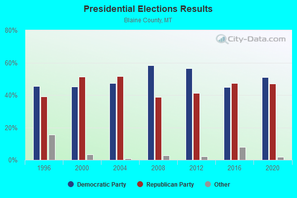
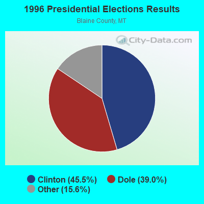
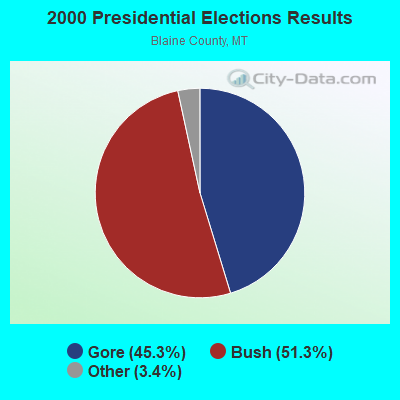


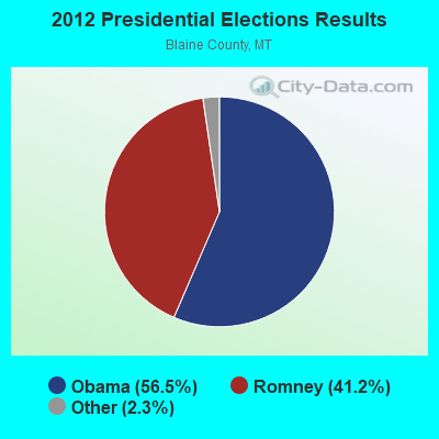
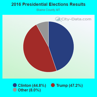
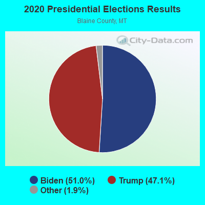
Graphs represent county-level data. Detailed 2008 Election Results
Religion statistics for Fort Belknap, MT (based on Blaine County data)
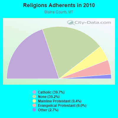
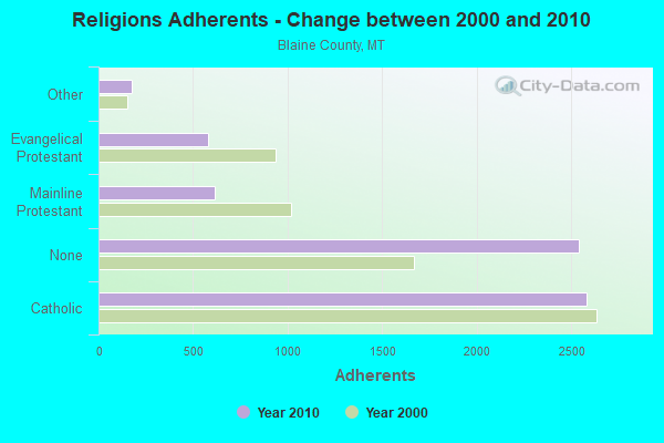
| Religion | Adherents | Congregations |
|---|---|---|
| Catholic | 2,580 | 6 |
| Mainline Protestant | 613 | 8 |
| Evangelical Protestant | 582 | 14 |
| Other | 173 | 2 |
| None | 2,543 | - |
Food Environment Statistics:
| This county: | 4.60 / 10,000 pop. |
| Montana: | 2.55 / 10,000 pop. |
| Blaine County: | 3.07 / 10,000 pop. |
| Montana: | 0.48 / 10,000 pop. |
| Blaine County: | 4.60 / 10,000 pop. |
| State: | 4.69 / 10,000 pop. |
| This county: | 6.13 / 10,000 pop. |
| Montana: | 10.38 / 10,000 pop. |
| Blaine County: | 10.1% |
| State: | 7.2% |
| Blaine County: | 32.9% |
| State: | 23.1% |
| This county: | 22.7% |
| Montana: | 10.7% |
Strongest AM radio stations in Fort Belknap:
- KERR (750 AM; 50 kW; POLSON, MT; Owner: ANDERSON RADIO BROADCASTING, INC.)
- KOFI (1180 AM; 50 kW; KALISPELL, MT; Owner: KOFI, INC.)
- KOJM (610 AM; 1 kW; HAVRE, MT; Owner: NEW MEDIA BROADCASTERS, INC.)
- KMON (560 AM; 5 kW; GREAT FALLS, MT; Owner: COMMONWEALTH LICENSE SUBSIDIARY, LLC)
- KSEN (1150 AM; 10 kW; SHELBY, MT; Owner: CAPSTAR TX LIMITED PARTNERSHIP)
- KXMR (710 AM; 50 kW; BISMARCK, ND; Owner: RADIO BISMARCK MANDAN, LLC)
- KGVW (640 AM; 10 kW; BELGRADE, MT; Owner: GALLATIN VALLEY WITNESS, INC.)
- KATL (770 AM; 10 kW; MILES CITY, MT; Owner: STAR PRINTING COMPANY)
- KTWO (1030 AM; 50 kW; CASPER, WY; Owner: CITICASTERS LICENSES, L.P.)
- KBOI (670 AM; 50 kW; BOISE, ID; Owner: CITADEL BROADCASTING COMPANY)
- KMTA (1050 AM; 10 kW; MILES CITY, MT; Owner: SENGER BROADCASTING CORPORATION)
- KALL (700 AM; 50 kW; NORTH SALT LAKE CITY, UT; Owner: CITICASTERS LICENSES, L.P.)
- KTBI (810 AM; daytime; 50 kW; EPHRATA, WA; Owner: TACOMA BROADCASTERS, INCORPORATED)
Strongest FM radio stations in Fort Belknap:
- KGVA (88.1 FM; FORT BELKNAP AGENCY, MT; Owner: FORT BELKNAP COLLEGE)
- KXEI (95.1 FM; HAVRE, MT; Owner: HI-LINE RADIO FELLOWSHIP, INC.)
- KNMC (90.1 FM; HAVRE, MT; Owner: NORTHERN MONTANA COLLEGE)
- KPQX (92.5 FM; HAVRE, MT; Owner: NEW MEDIA BROADCASTERS, INC.)
- KRYK (101.3 FM; CHINOOK, MT; Owner: NEW MEDIA BROADCASTERS, INC)
FCC Registered Cell Phone Towers:
1- MT02_FortBelknap, Se 1/4 Se 1/4 S 7, T 31 N, R 22 E (108941) (Lat: 48.453500 Lon: -108.914222), Type: Gtower, Structure height: 228.6 m, Overall height: 232 m, Call Sign: KNKN381
Assigned Frequencies: 869.040 MHz, 869.040 MHz, 869.040 MHz, 824.040 MHz, 824.040 MHz, 824.040 MHz, 890.010 MHz, 890.010 MHz, 890.010 MHz, 845.010 MHz, 845.010 MHz, 845.010 MHzGrant Date: 10/20/2020, Expiration Date: 10/01/2030, Certifier: Michael P GogginRegistrant: At&t Services, Inc., 208 S Akard St, 20f, Dallas, TX 75202, Phone: (855) 699-7073, Fax: (214) 746-6410, Email:
FCC Registered Antenna Towers:
1- 13 Mi S On Hwy 66 (Lat: 48.188333 Lon: -108.710833), Type: 213.0, Overall height: 213 m, Registrant: Fort Belknap College Dba , 159 Harle-m, Phone: (406) 353-4656
FCC Registered Microwave Towers:
1- FORT BELKNAP, Se 1/4 Se 1/4 S 7, T 31 N, R 22 E (Lat: 48.453500 Lon: -108.914222), Type: Gtower, Structure height: 228.6 m, Overall height: 232 m, Call Sign: WQZG640,
Assigned Frequencies: 5974.85 MHz, Grant Date: 05/10/2017, Expiration Date: 05/10/2027, Certifier: Dave Cundiff, Registrant: At&t Services, Inc., 208 S Akard St, 20f, Dallas, TX 75202, Phone: (855) 699-7073, Fax: (214) 746-6410, Email:

- 49.7%Bottled, tank, or LP gas
- 24.9%Utility gas
- 13.3%Electricity
- 10.8%Wood
- 0.8%Other fuel
- 0.5%Fuel oil, kerosene, etc.

- 34.0%Utility gas
- 30.1%Bottled, tank, or LP gas
- 30.1%Electricity
- 5.8%Wood
Fort Belknap compared to Montana state average:
- Median house value significantly below state average.
- Unemployed percentage above state average.
- Black race population percentage below state average.
- Hispanic race population percentage significantly below state average.
- Median age significantly below state average.
- Foreign-born population percentage significantly below state average.
- Renting percentage above state average.
- Length of stay since moving in significantly above state average.
- Number of rooms per house significantly below state average.
- House age significantly below state average.
- Percentage of population with a bachelor's degree or higher below state average.