Eureka Flat, Washington
Submit your own pictures of this place and show them to the world
- OSM Map
- General Map
- Google Map
- MSN Map

| Males: 932 | |
| Females: 808 |
| Median resident age: | 25.9 years |
| Washington median age: | 35.3 years |
Zip code: 99348
| Eureka Flat: | $65,756 |
| WA: | $91,306 |
Estimated per capita income in 2022: $24,538 (it was $11,269 in 2000)
Eureka Flat CCD income, earnings, and wages data
Estimated median house or condo value in 2022: $285,931 (it was $78,200 in 2000)
| Eureka Flat: | $285,931 |
| WA: | $569,500 |
Detailed information about poverty and poor residents in Eureka Flat, WA


- 89253.4%Hispanic
- 74344.5%White alone
- 110.7%Two or more races
- 100.6%American Indian alone
- 80.5%Black alone
- 70.4%Asian alone

Races in Eureka Flat detailed stats: ancestries, foreign born residents, place of birth
 Recent articles from our blog. Our writers, many of them Ph.D. graduates or candidates, create easy-to-read articles on a wide variety of topics.
Current Local Time: PST time zone
Land area: 511.6 square miles.
Population density: 3.4 people per square mile (very low).

| Eureka Flat CCD: | 0.8% ($647) |
| Washington: | 1.2% ($1,915) |
Nearest city with pop. 50,000+: Kennewick, WA  (33.4 miles , pop. 54,693).
Nearest city with pop. 200,000+: East Seattle, WA (193.1 miles , pop. 480,100).
Nearest city with pop. 1,000,000+: Los Angeles, CA (849.7 miles , pop. 3,694,820).
Nearest cities:
), Latitude: 46.37 N, Longitude: 118.50 W
Area code commonly used in this area: 509


| Here: | 5.1% |
| Washington: | 4.6% |

- Agriculture, forestry, fishing & hunting (52.4%)
- Educational services (6.1%)
- Construction (5.1%)
- Health care (4.2%)
- Groceries & related products merchant wholesalers (3.9%)
- Accommodation & food services (2.9%)
- Social assistance (2.8%)

- Agriculture, forestry, fishing & hunting (63.4%)
- Construction (7.7%)
- Educational services (4.2%)
- Groceries & related products merchant wholesalers (3.5%)
- Accommodation & food services (2.6%)
- Public administration (1.9%)
- Broadcasting & telecommunications (1.4%)

- Agriculture, forestry, fishing & hunting (36.1%)
- Health care (10.3%)
- Educational services (8.9%)
- Social assistance (6.5%)
- Groceries & related products merchant wholesalers (4.5%)
- Professional, scientific, technical services (3.8%)
- Accommodation & food services (3.4%)

- Agricultural workers, including supervisors (37.8%)
- Farmers and farm managers (7.6%)
- Building and grounds cleaning and maintenance occupations (3.5%)
- Electrical equipment mechanics and other installation, maintenance, and repair workers, including supervisors (2.9%)
- Preschool, kindergarten, elementary, and middle school teachers (2.5%)
- Other office and administrative support workers, including supervisors (2.2%)
- Bookkeeping, accounting, and auditing clerks (2.2%)

- Agricultural workers, including supervisors (41.0%)
- Farmers and farm managers (12.4%)
- Electrical equipment mechanics and other installation, maintenance, and repair workers, including supervisors (4.4%)
- Other material moving workers, except laborers (3.3%)
- Driver/sales workers and truck drivers (3.0%)
- Construction laborers (2.8%)
- Metal workers and plastic workers (2.8%)

- Agricultural workers, including supervisors (33.0%)
- Building and grounds cleaning and maintenance occupations (4.8%)
- Secretaries and administrative assistants (4.8%)
- Bookkeeping, accounting, and auditing clerks (4.8%)
- Preschool, kindergarten, elementary, and middle school teachers (4.1%)
- Laborers and material movers, hand (4.1%)
- Other office and administrative support workers, including supervisors (3.4%)
Average climate in Eureka Flat, Washington
Based on data reported by over 4,000 weather stations


(lower is better)

Air Quality Index (AQI) level in 2022 was 54.9. This is better than average.
| City: | 54.9 |
| U.S.: | 72.6 |

Particulate Matter (PM2.5) [µg/m3] level in 2022 was 6.35. This is better than average. Closest monitor was 22.7 miles away from the city center.
| City: | 6.35 |
| U.S.: | 8.11 |
Earthquake activity:
Eureka Flat-area historical earthquake activity is significantly above Washington state average. It is 1231% greater than the overall U.S. average.On 4/13/1949 at 19:55:42, a magnitude 7.0 (7.0 UK, Class: Major, Intensity: VIII - XII) earthquake occurred 198.7 miles away from the city center, causing $80,000,000 total damage
On 10/28/1983 at 14:06:06, a magnitude 7.3 (6.2 MB, 7.3 MS, 7.0 MW) earthquake occurred 278.5 miles away from Eureka Flat center, causing 2 deaths (2 shaking deaths) and 3 injuries, causing $15,000,000 total damage
On 2/28/2001 at 18:54:32, a magnitude 6.8 (6.5 MB, 6.6 MS, 6.8 MW, Class: Strong, Intensity: VII - IX) earthquake occurred 199.6 miles away from Eureka Flat center, causing $2,000,000,000 total damage and $305,000,000 insured losses
On 2/28/2001 at 18:54:32, a magnitude 6.8 (6.8 MD, Depth: 32.2 mi) earthquake occurred 207.2 miles away from Eureka Flat center
On 8/18/1959 at 06:37:13, a magnitude 7.7 (7.7 UK) earthquake occurred 400.4 miles away from Eureka Flat center, causing $26,000,000 total damage
On 4/29/1965 at 15:28:43, a magnitude 6.6 (6.6 UK) earthquake occurred 192.6 miles away from Eureka Flat center, causing $28,000,000 total damage
Magnitude types: body-wave magnitude (MB), duration magnitude (MD), surface-wave magnitude (MS), moment magnitude (MW)
Natural disasters:
The number of natural disasters in Walla Walla County (11) is smaller than the US average (15).Major Disasters (Presidential) Declared: 7
Emergencies Declared: 1
Causes of natural disasters: Floods: 5, Winter Storms: 3, Landslides: 2, Mudslides: 2, Storms: 2, Earthquake: 1, Fire: 1, Heavy Rain: 1, Hurricane: 1, Snow: 1, Volcanic Eruption: 1, Other: 1 (Note: some incidents may be assigned to more than one category).
Colleges/universities with over 2000 students nearest to Eureka Flat:
- Walla Walla Community College (about 23 miles; Walla Walla, WA; Full-time enrollment: 4,263)
- Columbia Basin College (about 31 miles; Pasco, WA; FT enrollment: 5,111)
- Washington State University (about 69 miles; Pullman, WA; FT enrollment: 25,055)
- Lewis-Clark State College (about 71 miles; Lewiston, ID; FT enrollment: 3,199)
- University of Idaho (about 75 miles; Moscow, ID; FT enrollment: 10,416)
- Eastern Oregon University (about 76 miles; La Grande, OR; FT enrollment: 3,127)
- Eastern Washington University (about 89 miles; Cheney, WA; FT enrollment: 11,643)
Points of interest:
Notable locations in Eureka Flat: Baker Farm (A), Ayer Boat Basin (B), De Ruwe Farm (C), Hair Farm (D), Lasater Farm (E), Pleasant View (F), Reser (G), Tucker Farm (H), Simmons (I), Ayer Junction (J), McCall (K), Magallon Ranch (L), Walla Walla County Fire District 1 (M), Walla Walla County Fire District 3 Eureka Fire District (N), Walla Walla County Fire Protection District 7 (O). Display/hide their locations on the map
Cemetery: Ivy Cemetery (1). Display/hide its location on the map
Reservoir: Lake Herbert G West (A). Display/hide its location on the map
Creeks: Whetstone Creek (A), McKay Creek (B). Display/hide their locations on the map
Park in Eureka Flat: Fishhook Park (1). Display/hide its location on the map
| This place: | 3.0 people |
| Washington: | 2.5 people |
| This place: | 73.1% |
| Whole state: | 64.4% |
| This place: | 8.6% |
| Whole state: | 7.7% |
Likely homosexual households (counted as self-reported same-sex unmarried-partner households)
- Lesbian couples: 0.5% of all households
- Gay men: 0.2% of all households
| This place: | 20.4% |
| Whole state: | 10.6% |
| This place: | 6.6% |
| Whole state: | 4.6% |
24 people in other nonhousehold living situations in 2000
For population 15 years and over in Eureka Flat:

- Never married: 22.5%
- Now married: 69.6%
- Separated: 1.1%
- Widowed: 2.6%
- Divorced: 5.2%
For population 25 years and over in Eureka Flat:
- High school or higher: 61.9%
- Bachelor's degree or higher: 9.7%
- Graduate or professional degree: 3.3%
- Unemployed: 4.5%
- Mean travel time to work (commute): 18.6 minutes


| Here: | 22.1 |
| Washington average: | 11.3 |
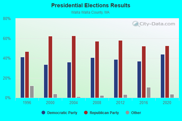
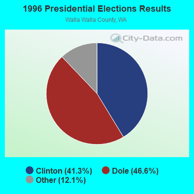
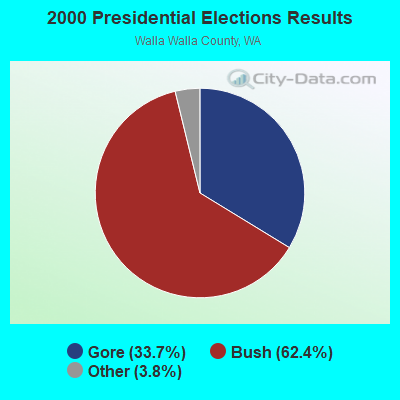
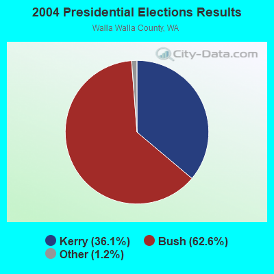
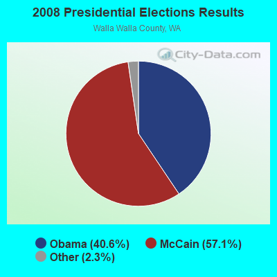
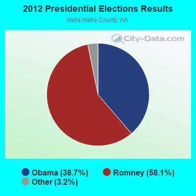
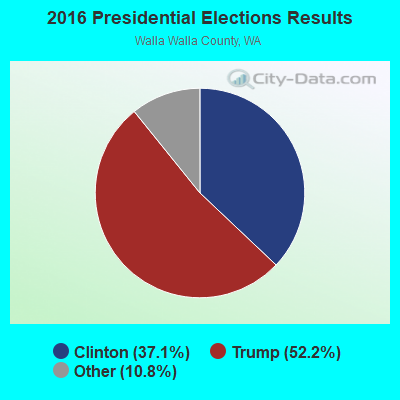
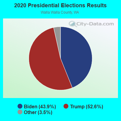
Graphs represent county-level data. Detailed 2008 Election Results
Religion statistics for Eureka Flat, WA (based on Walla Walla County data)
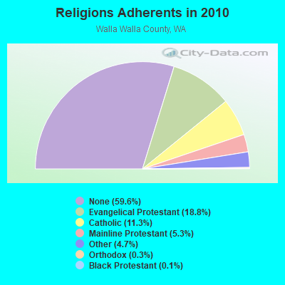
| Religion | Adherents | Congregations |
|---|---|---|
| Evangelical Protestant | 11,036 | 44 |
| Catholic | 6,630 | 5 |
| Mainline Protestant | 3,109 | 12 |
| Other | 2,761 | 12 |
| Orthodox | 160 | 1 |
| Black Protestant | 72 | 1 |
| None | 35,013 | - |
Food Environment Statistics:
| Walla Walla County: | 2.45 / 10,000 pop. |
| Washington: | 2.06 / 10,000 pop. |
| This county: | 0.18 / 10,000 pop. |
| Washington: | 0.19 / 10,000 pop. |
| Walla Walla County: | 0.70 / 10,000 pop. |
| Washington: | 1.18 / 10,000 pop. |
| This county: | 1.93 / 10,000 pop. |
| State: | 2.67 / 10,000 pop. |
| This county: | 5.95 / 10,000 pop. |
| Washington: | 8.26 / 10,000 pop. |
| This county: | 8.2% |
| Washington: | 7.7% |
| Here: | 24.8% |
| State: | 25.7% |
| Walla Walla County: | 12.8% |
| Washington: | 13.9% |
Strongest AM radio stations in Eureka Flat:
- KFLD (870 AM; 10 kW; PASCO, WA; Owner: CAPSTAR TX LIMITED PARTNERSHIP)
- KTBI (810 AM; daytime; 50 kW; EPHRATA, WA; Owner: TACOMA BROADCASTERS, INCORPORATED)
- KONA (610 AM; 5 kW; KENNEWICK-RICHLAND-P, WA; Owner: COMMONWEALTH LICENSE SUBSIDIARY, LLC)
- KUJ (1420 AM; 5 kW; WALLA WALLA, WA; Owner: ALEXANDRA COMMUNICATIONS)
- KQQQ (1150 AM; 25 kW; PULLMAN, WA; Owner: RADIO PALOUSE, INC.)
- KALE (960 AM; 5 kW; RICHLAND, WA; Owner: NEW NORTHWEST BROADCASTERS, LLC)
- KGA (1510 AM; 50 kW; SPOKANE, WA; Owner: CITADEL BROADCASTING COMPANY)
- KMAX (840 AM; 10 kW; COLFAX, WA; Owner: PALOUSE COUNTRY, INC.)
- KXLY (920 AM; 20 kW; SPOKANE, WA; Owner: SPOKANE RADIO, INC.)
- KPOJ (620 AM; 50 kW; PORTLAND, OR; Owner: CITICASTERS LICENSES, L.P.)
- KIRO (710 AM; 50 kW; SEATTLE, WA; Owner: ENTERCOM SEATTLE LICENSE, LLC)
- KUMA (1290 AM; 5 kW; PENDLETON, OR; Owner: ROUND-UP RADIO, INC.)
- KTTH (770 AM; 50 kW; SEATTLE, WA; Owner: ENTERCOM SEATTLE LICENSE, LLC)
Strongest FM radio stations in Eureka Flat:
- KHSS (100.7 FM; WALLA WALLA, WA; Owner: TWO HEARTS COMMUNICATIONS, LLC)
- KZHR (92.5 FM; DAYTON, WA; Owner: COMMONWEALTH LICENSE SUBSIDIARY, LLC)
- KNLT (95.7 FM; WALLA WALLA, WA; Owner: NEW NORTHWEST BROADCASTERS, LLC)
- KRKL (93.3 FM; WALLA WALLA, WA; Owner: EDUCATIONAL MEDIA FOUNDATION)
- KWWS (89.7 FM; WALLA WALLA, WA; Owner: WASHINGTON STATE UNIVERSITY)
- KXRX (97.1 FM; WALLA WALLA, WA; Owner: CAPSTAR TX LIMITED PARTNERSHIP)
- KGTS (91.3 FM; COLLEGE PLACE, WA; Owner: WALLA WALLA COLLEGE)
- KUJ-FM (99.1 FM; WALLA WALLA, WA; Owner: ALEXANDRA COMMUNICATIONS)
- KOLW (97.9 FM; MILTON-FREEWATER, OR; Owner: CAPSTAR TX LIMITED PARTNERSHIP)
- KIOK (94.9 FM; RICHLAND, WA; Owner: NEW NORTHWEST BROADCASTERS, LLC)
- KONA-FM (105.3 FM; KENNEWICK, WA; Owner: COMMONWEALTH LICENSE SUBSIDIARY, LLC)
- KEYW (98.3 FM; PASCO, WA; Owner: CAPSTAR TX LIMITED PARTNERSHIP)
- K261CG (100.1 FM; PASCO, WA; Owner: NORTHWEST CHICANO RADIO NETWORK)
- KFAE-FM (89.1 FM; RICHLAND, WA; Owner: WASHINGTON STATE UNIVERSITY)
- KUBQ (98.7 FM; LA GRANDE, OR; Owner: GRANDE RADIO, INC.)
- KORD-FM (102.7 FM; RICHLAND, WA; Owner: CAPSTAR TX LIMITED PARTNERSHIP)
- KEGX (106.5 FM; RICHLAND, WA; Owner: NEW NORTHWEST BROADCASTERS, LLC)
- KOLU (90.1 FM; PASCO, WA; Owner: RIVERVIEW BAPTIST CHRISTIAN SCHOOLS)
- KGDN (101.3 FM; PASCO, WA; Owner: WEST PASCO FINE ARTS RADIO)
- KBLD (91.7 FM; KENNEWICK, WA; Owner: CSN INTERNATIONAL)

- 67.1%Electricity
- 14.6%Fuel oil, kerosene, etc.
- 9.8%Bottled, tank, or LP gas
- 8.5%Wood

- 80.9%Electricity
- 15.7%Fuel oil, kerosene, etc.
- 2.2%Bottled, tank, or LP gas
- 1.3%Wood
Eureka Flat compared to Washington state average:
- Median house value below state average.
- Unemployed percentage significantly below state average.
- Black race population percentage significantly below state average.
- Hispanic race population percentage significantly above state average.
- Median age below state average.
- Foreign-born population percentage significantly below state average.
- Renting percentage above state average.
- Length of stay since moving in significantly above state average.
- Number of rooms per house significantly below state average.
- House age significantly below state average.
- Percentage of population with a bachelor's degree or higher significantly below state average.
Eureka Flat on our top lists:
- #69 on the list of "Top 101 cities with the largest percentage of people in other nonhousehold living situations (population 1,000+)"
- #68 (99348) on the list of "Top 101 zip codes with the lowest charity contributions deductions as a percentage of AGI in 2012 (pop 1,000+)"
- #97 (99348) on the list of "Top 101 zip codes with the largest percentage of returns reporting salary or wage in 2012 (pop 1,000+)"