Empress, Georgia
Submit your own pictures of this place and show them to the world
- OSM Map
- General Map
- Google Map
- MSN Map

| Males: 539 | |
| Females: 537 |
| Median resident age: | 39.0 years |
| Georgia median age: | 33.4 years |
Zip code: 31643
| Empress: | $45,015 |
| GA: | $72,837 |
Estimated per capita income in 2022: $41,288 (it was $20,316 in 2000)
Empress CCD income, earnings, and wages data
Estimated median house or condo value in 2022: $153,049 (it was $54,600 in 2000)
| Empress: | $153,049 |
| GA: | $297,400 |
Detailed information about poverty and poor residents in Empress, GA


- 93085.8%White alone
- 13512.5%Black alone
- 100.9%Two or more races
- 60.6%Hispanic
- 30.3%American Indian alone

Races in Empress detailed stats: ancestries, foreign born residents, place of birth
 Recent articles from our blog. Our writers, many of them Ph.D. graduates or candidates, create easy-to-read articles on a wide variety of topics.
Current Local Time: EST time zone
Elevation: 126 feet
Land area: 76.8 square miles.
Population density: 14 people per square mile (very low).

| Empress CCD: | 0.7% ($360) |
| Georgia: | 0.9% ($919) |
Nearest city with pop. 50,000+: Tallahassee, FL  (48.4 miles , pop. 150,624).
Nearest city with pop. 200,000+: Jacksonville, FL (113.1 miles , pop. 735,617).
Nearest city with pop. 1,000,000+: Houston, TX (712.2 miles , pop. 1,953,631).
Nearest cities:
), ), Latitude: 30.69 N, Longitude: 83.51 W
Area code commonly used in this area: 229


| Here: | 2.9% |
| Georgia: | 2.9% |

- Construction (13.1%)
- Health care (10.0%)
- Public administration (9.2%)
- Accommodation & food services (7.5%)
- Agriculture, forestry, fishing & hunting (6.2%)
- Educational services (5.8%)
- Social assistance (4.0%)

- Construction (24.5%)
- Agriculture, forestry, fishing & hunting (9.0%)
- Public administration (6.9%)
- Motor vehicle & parts dealers (5.4%)
- Accommodation & food services (4.7%)
- Plastics & rubber products (4.7%)
- Broadcasting & telecommunications (4.0%)

- Health care (18.1%)
- Educational services (12.3%)
- Public administration (11.9%)
- Accommodation & food services (10.7%)
- Social assistance (8.6%)
- Truck transportation (5.8%)
- Apparel (4.9%)

- Other production occupations, including supervisors (6.2%)
- Health technologists and technicians (5.0%)
- Sales representatives, services, wholesale and manufacturing (5.0%)
- Retail sales workers, except cashiers (4.0%)
- Building and grounds cleaning and maintenance occupations (3.8%)
- Electrical equipment mechanics and other installation, maintenance, and repair workers, including supervisors (3.8%)
- Other management occupations, except farmers and farm managers (3.7%)

- Sales representatives, services, wholesale and manufacturing (9.4%)
- Electrical equipment mechanics and other installation, maintenance, and repair workers, including supervisors (7.2%)
- Metal workers and plastic workers (6.9%)
- Other production occupations, including supervisors (6.9%)
- Retail sales workers, except cashiers (5.4%)
- Agricultural workers, including supervisors (5.4%)
- Law enforcement workers, including supervisors (4.7%)

- Health technologists and technicians (10.7%)
- Building and grounds cleaning and maintenance occupations (5.8%)
- Child care workers (5.8%)
- Material recording, scheduling, dispatching, and distributing workers (5.3%)
- Other production occupations, including supervisors (5.3%)
- Preschool, kindergarten, elementary, and middle school teachers (4.9%)
- Other teachers, instructors, education, training, and library occupations (4.9%)
Average climate in Empress, Georgia
Based on data reported by over 4,000 weather stations


(lower is better)

Air Quality Index (AQI) level in 2023 was 78.1. This is about average.
| City: | 78.1 |
| U.S.: | 72.6 |

Particulate Matter (PM2.5) [µg/m3] level in 2023 was 10.6. This is worse than average. Closest monitor was 16.9 miles away from the city center.
| City: | 10.6 |
| U.S.: | 8.1 |

Lead (Pb) [µg/m3] level in 2008 was 0.00215. This is significantly better than average. Closest monitor was 16.9 miles away from the city center.
| City: | 0.00215 |
| U.S.: | 0.00931 |
Tornado activity:
Empress-area historical tornado activity is slightly below Georgia state average. It is 1% greater than the overall U.S. average.
On 4/19/1988, a category F3 (max. wind speeds 158-206 mph) tornado 17.3 miles away from the Empress place center killed 4 people and injured 18 people and caused between $5,000,000 and $50,000,000 in damages.
On 3/26/1963, a category F2 (max. wind speeds 113-157 mph) tornado 10.5 miles away from the place center caused between $5000 and $50,000 in damages.
Earthquake activity:
Empress-area historical earthquake activity is above Georgia state average. It is 75% smaller than the overall U.S. average.On 9/10/2006 at 14:56:08, a magnitude 5.9 (5.9 MB, 5.5 MS, 5.8 MW, Class: Moderate, Intensity: VI - VII) earthquake occurred 360.9 miles away from the city center
On 10/24/1997 at 08:35:17, a magnitude 4.9 (4.8 MB, 4.2 MS, 4.9 LG, Depth: 6.2 mi, Class: Light, Intensity: IV - V) earthquake occurred 225.3 miles away from the city center
On 8/2/1974 at 08:52:09, a magnitude 4.9 (4.3 MB, 4.9 LG) earthquake occurred 228.1 miles away from Empress center
On 11/22/1974 at 05:25:55, a magnitude 4.7 (4.7 MB) earthquake occurred 250.0 miles away from the city center
On 4/29/2003 at 08:59:39, a magnitude 4.9 (4.4 MB, 4.6 MW, 4.9 LG) earthquake occurred 290.7 miles away from the city center
On 1/18/1999 at 07:00:53, a magnitude 4.8 (4.8 MB, 4.0 LG, Depth: 0.6 mi) earthquake occurred 289.0 miles away from the city center
Magnitude types: regional Lg-wave magnitude (LG), body-wave magnitude (MB), surface-wave magnitude (MS), moment magnitude (MW)
Natural disasters:
The number of natural disasters in Brooks County (11) is smaller than the US average (15).Major Disasters (Presidential) Declared: 6
Emergencies Declared: 3
Causes of natural disasters: Floods: 4, Storms: 4, Tornadoes: 4, Winds: 3, Hurricanes: 2, Drought: 1, Heavy Rain: 1, Snowfall: 1, Tropical Storm: 1, Winter Storm: 1, Other: 1 (Note: some incidents may be assigned to more than one category).
Hospitals and medical centers near Empress:
- PRESBYTERIAN HOME INC (Nursing Home, about 7 miles away; QUITMAN, GA)
- PRESBYTERIAN HOME, QUITMAN, IN (Nursing Home, about 7 miles away; QUITMAN, GA)
- PRESBYTERIAN HOSPICE AND PALLIATIVE CARE CENTER (Hospital, about 8 miles away; QUITMAN, GA)
- BROOKS COUNTY DIALYSIS FACILITY (Dialysis Facility, about 8 miles away; QUITMAN, GA)
- BROOKS COUNTY HOSPITAL Critical Access Hospitals (about 8 miles away; QUITMAN, GA)
- GENTIVA HEALTH SERVICES (Home Health Center, about 16 miles away; MADISON, FL)
Colleges/universities with over 2000 students nearest to Empress:
- Wiregrass Georgia Technical College (about 17 miles; Valdosta, GA; Full-time enrollment: 3,246)
- Valdosta State University (about 18 miles; Valdosta, GA; FT enrollment: 11,155)
- Florida Agricultural and Mechanical University (about 50 miles; Tallahassee, FL; FT enrollment: 10,841)
- Florida State University (about 50 miles; Tallahassee, FL; FT enrollment: 38,283)
- Tallahassee Community College (about 53 miles; Tallahassee, FL; FT enrollment: 10,904)
- Abraham Baldwin Agricultural College (about 55 miles; Tifton, GA; FT enrollment: 2,564)
- Bainbridge State College (about 63 miles; Bainbridge, GA; FT enrollment: 2,308)
Points of interest:
Notable location: South Brooks Volunteer Fire Department (A). Display/hide its location on the map
Churches in Empress include: Church of the Lord (A), Liberty Church (B), Pineview Church (C), Ochlawilla Church (D), Saint Paul Church (E), Saint Philip Church (F), Elam Church (G), Simmons Hill Church (H), Columbia Primitive Baptist Church (I). Display/hide their locations on the map
Cemeteries: Johson Cemetery (1), Simmons Hill Cemetery (2), Wade Cemetery (3), Worn Cemetery (4), Union Cemetery (5), Columbia Primitive Baptist Church Cemetery (6). Display/hide their locations on the map
Lakes, reservoirs, and swamps: Mud Lake (A), Fearnside Lake (B), Langdale Company Lake (C), Childers Pond (D), Denmark Lake (E), Purdy Lake (F), Sims Lake (G). Display/hide their locations on the map
Streams, rivers, and creeks: Pine Branch (A). Display/hide its location on the map
| This place: | 2.5 people |
| Georgia: | 2.6 people |
| This place: | 71.8% |
| Whole state: | 68.5% |
| This place: | 5.5% |
| Whole state: | 5.9% |
Likely homosexual households (counted as self-reported same-sex unmarried-partner households)
- Lesbian couples: 0.9% of all households
- Gay men: 0.2% of all households
| This place: | 20.8% |
| Whole state: | 13.0% |
| This place: | 7.6% |
| Whole state: | 6.1% |
For population 15 years and over in Empress:

- Never married: 18.0%
- Now married: 60.6%
- Separated: 2.7%
- Widowed: 8.7%
- Divorced: 12.7%
For population 25 years and over in Empress:
- High school or higher: 61.1%
- Bachelor's degree or higher: 11.1%
- Graduate or professional degree: 2.8%
- Unemployed: 4.1%
- Mean travel time to work (commute): 27.2 minutes


| Here: | 14.0 |
| Georgia average: | 13.3 |
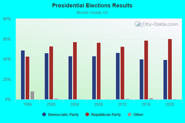
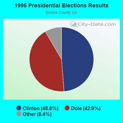
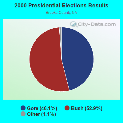
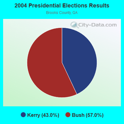
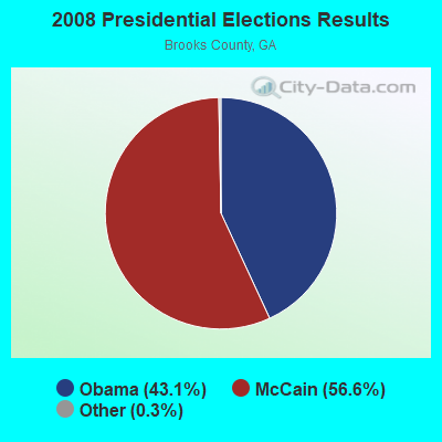
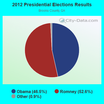
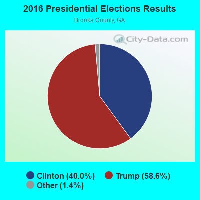
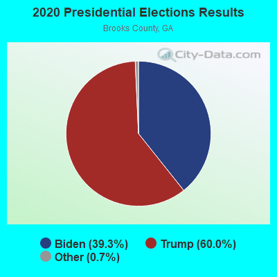
Graphs represent county-level data. Detailed 2008 Election Results
Religion statistics for Empress, GA (based on Brooks County data)
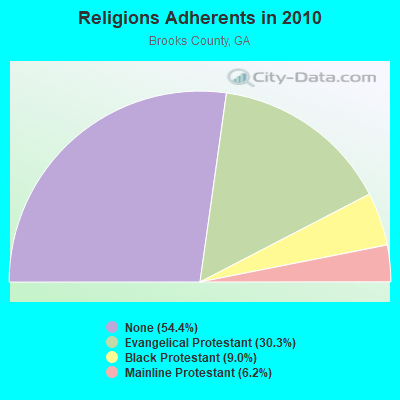
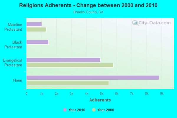
| Religion | Adherents | Congregations |
|---|---|---|
| Evangelical Protestant | 4,929 | 28 |
| Black Protestant | 1,464 | 9 |
| Mainline Protestant | 1,015 | 13 |
| Other | 4 | 1 |
| None | 8,831 | - |
Food Environment Statistics:
| Brooks County: | 1.84 / 10,000 pop. |
| State: | 1.91 / 10,000 pop. |
| This county: | 1.23 / 10,000 pop. |
| State: | 0.86 / 10,000 pop. |
| Here: | 4.90 / 10,000 pop. |
| Georgia: | 5.12 / 10,000 pop. |
| Brooks County: | 1.84 / 10,000 pop. |
| Georgia: | 7.41 / 10,000 pop. |
| Brooks County: | 13.2% |
| Georgia: | 10.4% |
| Brooks County: | 31.7% |
| Georgia: | 27.8% |
| This county: | 12.3% |
| Georgia: | 14.6% |
Strongest AM radio stations in Empress:
- WGOV (950 AM; 4 kW; VALDOSTA, GA; Owner: W G O V, INC.)
- WSTT (730 AM; 25 kW; THOMASVILLE, GA; Owner: MARION R. WILLIAMS)
- WFVR (910 AM; 50 kW; VALDOSTA, GA; Owner: RAMA COMMUNICATIONS, INC.)
- WHGH (840 AM; daytime; 10 kW; THOMASVILLE, GA; Owner: H. G. H INVESTMENT CORP.)
- WSFB (1490 AM; 1 kW; QUITMAN, GA; Owner: JIM CHION)
- WJEM (1150 AM; 5 kW; VALDOSTA, GA; Owner: WJEM, INC.)
- WJEP (1020 AM; daytime; 10 kW; OCHLOCKNEE, GA; Owner: LIFELINE MINISTRIES, INCORPORATED)
- WTHV (810 AM; daytime; 2 kW; HAHIRA, GA; Owner: ETERNAL LIFE MINISTRIES, INC.)
- WOKV (690 AM; 50 kW; JACKSONVILLE, FL; Owner: COX RADIO, INC.)
- WMGA (1130 AM; 10 kW; MOULTRIE, GA; Owner: RADIO MOULTRIE, INC.)
- WFRF (1070 AM; daytime; 10 kW; TALLAHASSEE, FL; Owner: FAITH RADIO NETWORK, INC.)
- WMAF (1230 AM; 1 kW; MADISON, FL; Owner: GENEVA WALKER)
- WMTM (1300 AM; 5 kW; MOULTRIE, GA; Owner: COLQUITT BROADCASTING COMPANY, LLC)
Strongest FM radio stations in Empress:
- WSTI-FM (105.3 FM; QUITMAN, GA; Owner: MAGNUM BROADCASTING, INC.)
- WYZK (96.7 FM; VALDOSTA, GA; Owner: C. D. J., INC.)
- WWRQ-FM (107.9 FM; VALDOSTA, GA; Owner: RTG RADIO, LLC)
- WAAC (92.9 FM; VALDOSTA, GA; Owner: WGOV, INC.)
- WKVH (91.9 FM; MONTICELLO, FL; Owner: EDUCATIONAL MEDIA FOUNDATION)
- WAFT (101.1 FM; VALDOSTA, GA; Owner: CHRISTIAN RADIO FELLOWSHIP, INC.)
- WFSU-FM (88.9 FM; TALLAHASSEE, FL; Owner: FLORIDA STATE UNIVERSITY)
- WGLF (104.1 FM; TALLAHASSEE, FL; Owner: CUMULUS LICENSING CORP.)
- WXHT (102.7 FM; MADISON, FL; Owner: MAGNUM BROADCASTING, INC.)
- WTUF (106.3 FM; BOSTON, GA; Owner: BOSTON RADIO COMPANY, INC.)
- WDMG-FM (99.5 FM; DOUGLAS, GA; Owner: RTG RADIO, LLC)
- WQPW (95.7 FM; VALDOSTA, GA; Owner: RTG RADIO, LLC)
- WJYF (95.3 FM; NASHVILLE, GA; Owner: TIFTON BROADCASTING CORP.)
- WVHT (105.7 FM; MONTICELLO, FL; Owner: WILSON BROADCASTING, INC.)
- WWET (91.7 FM; VALDOSTA, GA; Owner: GEORGIA PUBLIC TELECOMMUNICATIONS COMMISSION)
TV broadcast stations around Empress:
- WCTV (Channel 6; THOMASVILLE, GA; Owner: WCTV LICENSEE CORP.)
- WTWC-TV (Channel 40; TALLAHASSEE, FL; Owner: WTWC LICENSEE, LLC)
- W25CP (Channel 25; VALDOSTA, GA; Owner: TRINITY BROADCASTING NETWORK)
- WBFL-CA (Channel 13; VALDOSTA, GA; Owner: WTLH LICENSE CORP.)
- WTXL-TV (Channel 27; TALLAHASSEE, FL; Owner: MEDIA VENTURE MANAGEMENT, INC.)
- WTLH (Channel 49; BAINBRIDGE, GA; Owner: WTLH LICENSE CORP.)
- WBVJ-LP (Channel 35; VALDOSTA, GA; Owner: WTLH LICENSE CORP.)
- WABW-TV (Channel 14; PELHAM, GA; Owner: GEORGIA PUBLIC TELECOMMUNICATIONS COMMISSION)
- WFXU (Channel 57; LIVE OAK, FL; Owner: WFXU LICENSE CORPORATION)
- W38CM (Channel 22; THOMASVILLE, GA; Owner: NATIONAL MINORITY T.V., INC.)
- WVAG (Channel 44; VALDOSTA, GA; Owner: HUTCHENS COMMUNICATIONS, INC.)
FCC Registered Antenna Towers:
7- Janis E Merritts, Old Madison Road (Lat: 30.680833 Lon: -83.497500), Type: 108.9, Overall height: 103.9 m, Registrant: Pinnacle Towers Inc., Pinnacle@pintowers.Com, , Saras-ota, Phone: (941) 364-8886
- Janis E Merritts, Old Madison Road (Lat: 30.680861 Lon: -83.497611), Type: 105.8, Overall height: 103.9 m, Registrant: Pinnacle Towers Inc., Pinnacle@pintowers.Com, , Saras-ota, Phone: (941) 364-8886
- Janis E Merritts, Old Madison Road (Lat: 30.680861 Lon: -83.497611), Type: 105.8, Overall height: 103.9 m, Registrant: Pinnacle Towers Inc., Pinnacle@pintowers.Com, , Saras-ota, Phone: (941) 364-8886
- Janis E Merritts, Old Madison Road (Lat: 30.680861 Lon: -83.497611), Type: 105.8, Overall height: 103.9 m, Registrant: Pinnacle Towers LLC, Compliancedepartment@gsignal.Com, , Saras-ota, Phone: (941) 364-8886
- Christine A Verre, Old Madison Road (Lat: 30.680861 Lon: -83.497611), Type: 105.8, Overall height: 103.9 m, Registrant: Crown Castle Usa, Christine.Verre@crowncastle.Com, , Canon-sburg, Phone: (336) 643-2524
- Kimberly A Thomas, Old Madison Road (Lat: 30.680861 Lon: -83.497611), Type: 105.8, Overall height: 103.9 m, Registrant: Crown Castle Usa, Christine.Verre@crowncastle.Com, , Canon-sburg, Phone: (336) 643-2524
- Old Madison Road (Lat: 30.680833 Lon: -83.497500), Type: 108.9, Overall height: 103.9 m, Registrant: Pinnacle Towers Inc., Jmerritts@pintowers.Com, , Saras-ota, Phone: (941) 364-8886

- 61.0%Electricity
- 34.7%Bottled, tank, or LP gas
- 2.3%Utility gas
- 2.0%Wood

- 49.4%Electricity
- 43.5%Bottled, tank, or LP gas
- 7.1%Wood
Empress compared to Georgia state average:
- Median household income below state average.
- Median house value below state average.
- Unemployed percentage significantly below state average.
- Black race population percentage below state average.
- Hispanic race population percentage significantly below state average.
- Foreign-born population percentage significantly below state average.
- Renting percentage below state average.
- Length of stay since moving in significantly above state average.
- Number of rooms per house significantly below state average.
- House age significantly below state average.
- Percentage of population with a bachelor's degree or higher below state average.