Elmore, Vermont
Submit your own pictures of this town and show them to the world
- OSM Map
- Google Map
- MSN Map
Population change since 2000: +0.7%
 |
| Males: 416 | |
| Females: 439 |
| Median resident age: | 46.1 years |
| Vermont median age: | 45.8 years |
Zip codes: 05680.
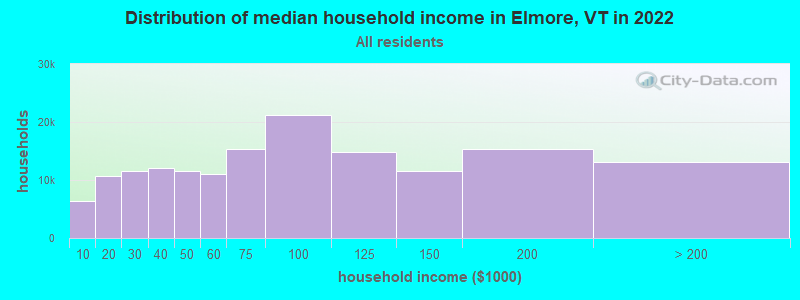
| Elmore: | $80,517 |
| VT: | $73,991 |
Estimated per capita income in 2022: $41,497 (it was $20,069 in 2000)
Elmore town income, earnings, and wages data
Estimated median house or condo value in 2022: $339,854 (it was $128,400 in 2000)
| Elmore: | $339,854 |
| VT: | $304,700 |
Detailed information about poverty and poor residents in Elmore, VT
Compare current foreclosures near Elmore, VT:
| Photo | Address | Area | Beds / Baths | Price | Details |
|---|---|---|---|---|---|

|
#1
Rocky Circle
Hardwick, VT 05843
|
1,960 sq. feet
|
2 baths 4 beds |
$244,900
|
show details |

|
#2
Cherry Street
Hardwick, VT 05843
|
- sq. feet
|
1 baths 2 beds |
show details | |

|
#3
E Hill Rd
Eden Mills, VT 05653
|
- sq. feet
|
- baths - beds |
show details | |

|
#4
Elm St Apt 3
Montpelier, VT 05602
|
- sq. feet
|
- baths - beds |
show details | |

|
#5
Main St Apt 2
Montpelier, VT 05602
|
- sq. feet
|
- baths - beds |
show details | |

|
#6
W Hill Rd
Worcester, VT 05682
|
- sq. feet
|
- baths - beds |
show details | |

|
#7
Vt Rte 214
Plainfield, VT 05667
|
- sq. feet
|
- baths - beds |
show details | |

|
Check over 1 million property listings on Foreclosure.com!
|
browse all offers | |||

- 83097.1%White alone
- 111.3%Hispanic
- 91.1%Two or more races
- 30.4%Asian alone
- 10.1%Black alone
- 10.1%American Indian alone

Races in Elmore detailed stats: ancestries, foreign born residents, place of birth
 Recent articles from our blog. Our writers, many of them Ph.D. graduates or candidates, create easy-to-read articles on a wide variety of topics.
Ancestries: United States (20.4%), Irish (12.8%), English (11.3%), German (11.3%), French (6.5%), Italian (5.5%).
Current Local Time: EST time zone
Land area: 39.2 square miles.
Population density: 22 people per square mile (very low).
32 residents are foreign born (1.4% North America, 1.2% Europe, 0.5% Asia, 0.5% Africa).
| This town: | 3.8% |
| Vermont: | 3.8% |
| Elmore town: | 1.3% ($1,686) |
| Vermont: | 2.0% ($2,196) |
Nearest city with pop. 50,000+: Manchester, NH  (117.5 miles , pop. 107,006).
Nearest city with pop. 200,000+: Boston, MA (166.9 miles , pop. 589,141).
Nearest city with pop. 1,000,000+: Bronx, NY (262.2 miles , pop. 1,332,650).
Nearest cities:
), ), ), ), Latitude: 44.50 N, Longitude: 72.51 W
Area code commonly used in this area: 802
Single-family new house construction building permits:
- 2022: 8 buildings, average cost: $625,000
- 2021: 9 buildings, average cost: $259,200
- 2020: 4 buildings, average cost: $250,000
- 2019: 5 buildings, average cost: $300,000
- 2018: 3 buildings, average cost: $200,000
- 2017: 5 buildings, average cost: $248,100
- 2016: 4 buildings, average cost: $373,100
- 2015: 4 buildings, average cost: $212,500
- 2014: 5 buildings, average cost: $240,000
- 2013: 1 building, cost: $200,000
- 2012: 2 buildings, average cost: $200,000
- 2011: 3 buildings, average cost: $166,700
- 2010: 2 buildings, average cost: $450,000
- 2009: 5 buildings, average cost: $160,000
- 2008: 8 buildings, average cost: $231,300
- 2007: 5 buildings, average cost: $240,000
- 2006: 23 buildings, average cost: $210,900
- 2004: 11 buildings, average cost: $138,800
- 2003: 12 buildings, average cost: $132,800
- 2002: 11 buildings, average cost: $130,700
- 2001: 14 buildings, average cost: $121,400
- 2000: 8 buildings, average cost: $118,000
- 1999: 5 buildings, average cost: $109,200
- 1998: 7 buildings, average cost: $101,700
- 1997: 11 buildings, average cost: $91,700


| Here: | 1.8% |
| Vermont: | 2.0% |


- Health care (13.8%)
- Construction (13.6%)
- Accommodation & food services (9.9%)
- Educational services (9.4%)
- Public administration (5.6%)
- Agriculture, forestry, fishing & hunting (3.4%)
- Publishing, motion picture & sound recording industries (2.7%)

- Construction (25.1%)
- Accommodation & food services (11.8%)
- Health care (10.0%)
- Agriculture, forestry, fishing & hunting (4.3%)
- Public administration (4.3%)
- Educational services (4.3%)
- Professional, scientific, technical services (3.8%)

- Health care (17.8%)
- Educational services (14.9%)
- Accommodation & food services (7.9%)
- Public administration (6.9%)
- Personal & laundry services (4.5%)
- Social assistance (3.5%)
- Arts, entertainment, recreation (3.0%)

- Other management occupations, except farmers and farm managers (5.3%)
- Carpenters (5.1%)
- Electrical equipment mechanics and other installation, maintenance, and repair workers, including supervisors (4.8%)
- Registered nurses (4.6%)
- Counselors, social workers, and other community and social service specialists (4.1%)
- Other sales and related occupations, including supervisors (4.1%)
- Other production occupations, including supervisors (3.6%)

- Carpenters (10.0%)
- Electrical equipment mechanics and other installation, maintenance, and repair workers, including supervisors (7.1%)
- Computer specialists (6.2%)
- Other food preparation and serving workers, including supervisors (5.7%)
- Other management occupations, except farmers and farm managers (5.2%)
- Top executives (4.7%)
- Other production occupations, including supervisors (3.8%)

- Registered nurses (9.4%)
- Counselors, social workers, and other community and social service specialists (7.4%)
- Secretaries and administrative assistants (6.4%)
- Preschool, kindergarten, elementary, and middle school teachers (5.9%)
- Other management occupations, except farmers and farm managers (5.4%)
- Other sales and related occupations, including supervisors (5.0%)
- Other production occupations, including supervisors (3.5%)
Average climate in Elmore, Vermont
Based on data reported by over 4,000 weather stations


(lower is better)

Air Quality Index (AQI) level in 2022 was 47.8. This is significantly better than average.
| City: | 47.8 |
| U.S.: | 72.6 |

Carbon Monoxide (CO) [ppm] level in 2022 was 0.00585. This is significantly better than average. Closest monitor was 17.7 miles away from the city center.
| City: | 0.00585 |
| U.S.: | 0.25132 |

Sulfur Dioxide (SO2) [ppb] level in 2022 was 0.0619. This is significantly better than average. Closest monitor was 17.7 miles away from the city center.
| City: | 0.0619 |
| U.S.: | 1.5147 |

Ozone [ppb] level in 2022 was 34.8. This is about average. Closest monitor was 17.7 miles away from the city center.
| City: | 34.8 |
| U.S.: | 33.3 |

Particulate Matter (PM2.5) [µg/m3] level in 2022 was 4.62. This is significantly better than average. Closest monitor was 17.7 miles away from the city center.
| City: | 4.62 |
| U.S.: | 8.11 |
Earthquake activity:
Elmore-area historical earthquake activity is significantly above Vermont state average. It is 72% smaller than the overall U.S. average.On 4/20/2002 at 10:50:47, a magnitude 5.3 (5.3 ML, Depth: 3.0 mi, Class: Moderate, Intensity: VI - VII) earthquake occurred 58.5 miles away from the city center
On 4/20/2002 at 10:50:47, a magnitude 5.2 (5.2 MB, 4.2 MS, 5.2 MW, 5.0 MW) earthquake occurred 59.6 miles away from Elmore center
On 10/7/1983 at 10:18:46, a magnitude 5.3 (5.1 MB, 5.3 LG, 5.1 ML) earthquake occurred 98.4 miles away from Elmore center
On 1/19/1982 at 00:14:42, a magnitude 4.7 (4.5 MB, 4.7 MD, 4.5 LG, Class: Light, Intensity: IV - V) earthquake occurred 82.9 miles away from Elmore center
On 10/16/2012 at 23:12:25, a magnitude 4.7 (4.7 ML, Depth: 10.0 mi) earthquake occurred 111.5 miles away from Elmore center
On 6/16/1995 at 12:13:11, a magnitude 3.8 (3.8 LG, Depth: 3.1 mi, Class: Light, Intensity: II - III) earthquake occurred 33.0 miles away from Elmore center
Magnitude types: regional Lg-wave magnitude (LG), body-wave magnitude (MB), duration magnitude (MD), local magnitude (ML), surface-wave magnitude (MS), moment magnitude (MW)
Natural disasters:
The number of natural disasters in Lamoille County (28) is a lot greater than the US average (15).Major Disasters (Presidential) Declared: 22
Emergencies Declared: 2
Causes of natural disasters: Floods: 20, Storms: 19, Tornadoes: 2, Tropical Storms: 2, Winds: 2, Winter Storms: 2, Heavy Rain: 1, Hurricane: 1, Landslide: 1, Snowstorm: 1, Other: 1 (Note: some incidents may be assigned to more than one category).
Hospitals and medical centers near Elmore:
- LAMOILLE HOME HEALTH AND HOSPICE (Home Health Center, about 6 miles away; MORRISVILLE, VT)
- THE MANOR, INC (Nursing Home, about 6 miles away; MORRISVILLE, VT)
- COPLEY HOSPITAL Critical Access Hospitals (about 6 miles away; MORRISVILLE, VT)
- ELMORE HOUSE AT COPLEY MANOR (Nursing Home, about 6 miles away; MORRISVILLE, VT)
Amtrak stations near Elmore:
- 17 miles: WATERBURY-STOWE (WATERBURY, PARK ROW) . Services: enclosed waiting area, public restrooms, public payphones, free short-term parking, free long-term parking, call for car rental service, call for taxi service, intercity bus service.
- 18 miles: MONTPELIER-BARRE (MONTPELIER, MONTPELIER JCT. RD.) . Services: enclosed waiting area, public restrooms, public payphones, free short-term parking, free long-term parking, call for car rental service, call for taxi service.
Colleges/universities with over 2000 students nearest to Elmore:
- Norwich University (about 27 miles; Northfield, VT; Full-time enrollment: 4,221)
- Saint Michael's College (about 33 miles; Colchester, VT; FT enrollment: 2,336)
- Community College of Vermont (about 34 miles; Winooski, VT; FT enrollment: 3,394)
- University of Vermont (about 34 miles; Burlington, VT; FT enrollment: 11,566)
- Champlain College (about 35 miles; Burlington, VT; FT enrollment: 2,623)
- Middlebury College (about 48 miles; Middlebury, VT; FT enrollment: 3,077)
- SUNY College at Plattsburgh (about 49 miles; Plattsburgh, NY; FT enrollment: 5,934)
Public elementary/middle school in Elmore:
- LAKE ELMORE SCHOOL (Students: 20, Location: 1199 VT ROUTE 12, Grades: 1-3)
Points of interest:
Notable location: Elmore Fire Department (A). Display/hide its location on the map
Church in Elmore: Elmore United Methodist Church (A). Display/hide its location on the map
Cemeteries: Elmore Mountain Cemetery (1), Lake Elmore Cemetery (2). Display/hide their locations on the map
Lakes and reservoirs: Russ Pond (A), Hardwood Pond (B), Hardwood Flats (C), Little Pond (D), Little Elmore Pond (E), Lake Elmore (F). Display/hide their locations on the map
Streams, rivers, and creeks: Barnes Brook (A). Display/hide its location on the map
Park in Elmore: Elmore State Park (1). Display/hide its location on the map
| This town: | 2.3 people |
| Vermont: | 2.3 people |
| This town: | 63.9% |
| Whole state: | 62.5% |
| This town: | 7.9% |
| Whole state: | 9.2% |
Likely homosexual households (counted as self-reported same-sex unmarried-partner households)
- Lesbian couples: 1.1% of all households
- Gay men: 0.3% of all households
| This town: | 6.3% |
| Whole state: | 9.4% |
| This town: | 1.5% |
| Whole state: | 3.6% |
For population 15 years and over in Elmore:

- Never married: 22.0%
- Now married: 60.5%
- Separated: 0.3%
- Widowed: 5.0%
- Divorced: 12.2%
For population 25 years and over in Elmore:
- High school or higher: 88.1%
- Bachelor's degree or higher: 38.0%
- Graduate or professional degree: 19.4%
- Unemployed: 6.8%
- Mean travel time to work (commute): 28.3 minutes


| Here: | 12.8 |
| Vermont average: | 11.7 |
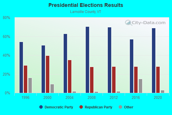
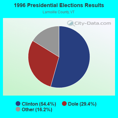
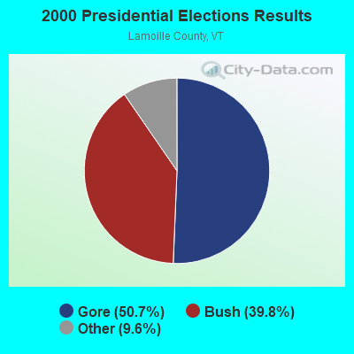
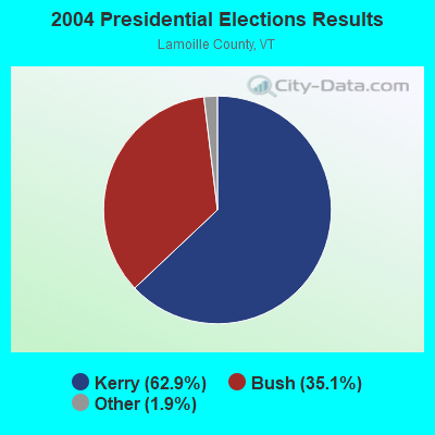

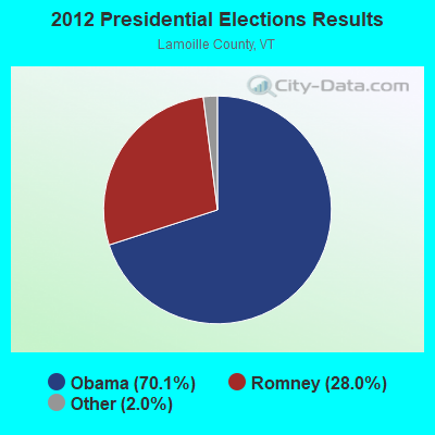
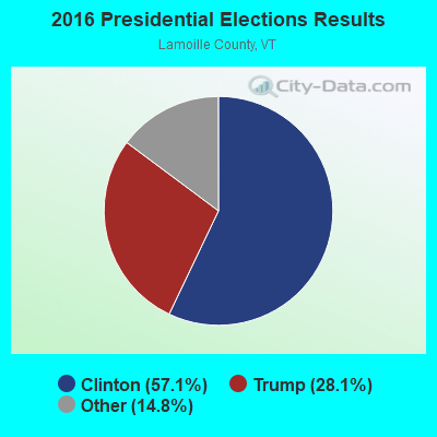
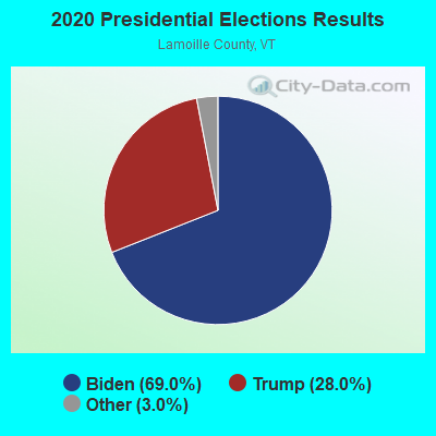
Graphs represent county-level data. Detailed 2008 Election Results
Religion statistics for Elmore, VT (based on Lamoille County data)
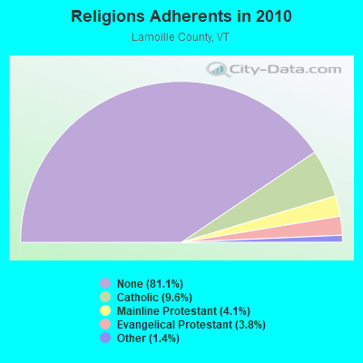
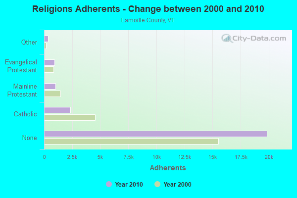
| Religion | Adherents | Congregations |
|---|---|---|
| Catholic | 2,339 | 7 |
| Mainline Protestant | 1,006 | 11 |
| Evangelical Protestant | 939 | 9 |
| Other | 344 | 4 |
| None | 19,847 | - |
Food Environment Statistics:
| Lamoille County: | 4.46 / 10,000 pop. |
| Vermont: | 3.84 / 10,000 pop. |
| This county: | 3.24 / 10,000 pop. |
| State: | 1.95 / 10,000 pop. |
| Lamoille County: | 6.08 / 10,000 pop. |
| Vermont: | 6.40 / 10,000 pop. |
| Lamoille County: | 16.22 / 10,000 pop. |
| Vermont: | 11.52 / 10,000 pop. |
| This county: | 6.5% |
| Vermont: | 6.8% |
| This county: | 23.1% |
| State: | 22.3% |
| Lamoille County: | 13.8% |
| Vermont: | 13.3% |
Strongest AM radio stations in Elmore:
- WDEV (550 AM; 5 kW; WATERBURY, VT; Owner: RADIO VERMONT, INC.)
- WCHP (760 AM; 35 kW; CHAMPLAIN, NY; Owner: CHAMPLAIN RADIO, INC.)
- WVMT (620 AM; 5 kW; BURLINGTON, VT; Owner: SISON BROADCASTING, INC.)
- WICY (1490 AM; 50 kW; MALONE, NY; Owner: CARTIER COMMUNICATIONS INC.)
- WTWN (1100 AM; daytime; 5 kW; WELLS RIVER, VT; Owner: PUFFER BROADCASTING, INC.)
- WGY (810 AM; 50 kW; SCHENECTADY, NY; Owner: CLEAR CHANNEL BROADCASTING LICENSES, INC.)
- WVAA (1390 AM; 5 kW; BURLINGTON, VT; Owner: RADIO VERMONT, KDR, LLC)
- WRKO (680 AM; 50 kW; BOSTON, MA; Owner: ENTERCOM BOSTON LICENSE, LLC)
- WNNZ (640 AM; 50 kW; WESTFIELD, MA; Owner: CLEAR CHANNEL BROADCASTING LICENSES, INC.)
- WSKI (1240 AM; 1 kW; MONTPELIER, VT; Owner: GALLOWAY COMMUNICATIONS, INC.)
- WEAV (960 AM; 5 kW; PLATTSBURGH, NY; Owner: CLEAR CHANNEL BROADCASTING LICENSES, INC.)
- WCRN (830 AM; 50 kW; WORCESTER, MA; Owner: CARTER BROADCASTING CORPORATION)
- WTWK (1070 AM; daytime; 5 kW; PLATTSBURGH, NY; Owner: CHAMPLAIN COMMUNICATIONS CORPORATION)
Strongest FM radio stations in Elmore:
- WLKC (103.3 FM; WATERBURY, VT; Owner: RADIO BROADCASTING SERVICES, INC.)
- WVPS (107.9 FM; BURLINGTON, VT; Owner: VERMONT PUBLIC RADIO)
- WEZF (92.9 FM; BURLINGTON, VT; Owner: CAPSTAR TX LIMITED PARTNERSHIP)
- WCVT (101.7 FM; STOWE, VT; Owner: RADIO VERMONT CLASSICS, L.L.C.)
- WNCS (104.7 FM; MONTPELIER, VT; Owner: MONTPELIER BROADCASTING, INC.)
- WDOT (95.7 FM; DANVILLE, VT; Owner: MONTPELIER BROADCASTING INC)
- WDEV-FM (96.1 FM; WARREN, VT; Owner: RADIO VERMONT, INC.)
- WGMT (97.7 FM; LYNDON, VT; Owner: VERMONT BROADCAST ASSOCIATES, INC.)
- WPKQ (103.7 FM; NORTH CONWAY, NH; Owner: CITADEL BROADCASTING COMPANY)
- WHOM (94.9 FM; MT. WASHINGTON, NH; Owner: CITADEL BROADCASTING COMPANY)
- WGLY-FM (91.5 FM; BOLTON, VT; Owner: CHRISTIAN MINISTRIES, INC.)
- WEBK (105.3 FM; KILLINGTON, VT; Owner: 6 JOHNSON ROAD LICENSES, INC.)
- WJJR (98.1 FM; RUTLAND, VT; Owner: 6 JOHNSON ROAD LICENSES, INC.)
- WZRT (97.1 FM; RUTLAND, VT; Owner: CAPSTAR TX LIMITED PARTNERSHIP)
- WCEL (91.9 FM; PLATTSBURGH, NY; Owner: WAMC)
- WMTK (106.3 FM; LITTLETON, NH; Owner: VERMONT BROADCAST ASSOCIATES, INC.)
- WGLV (91.7 FM; WOODSTOCK, VT; Owner: CHRISTIAN MINISTRIES INC)
- WHDQ-FM1 (106.1 FM; RUTLAND, VT; Owner: GREAT NORTHERN RADIO, L.L.C.)
- WCKJ (90.5 FM; ST. JOHNSBURY, VT; Owner: CHRISTIAN MINISTRIES, INC.)
- WKXH (105.5 FM; ST. JOHNSBURY, VT; Owner: VERMONT BROADCAST ASSOCIATES, INC.)
TV broadcast stations around Elmore:
- WVNY (Channel 22; BURLINGTON, VT; Owner: C-22 FCC LICENSEE SUBSIDIARY, LLC)
- WCAX-TV (Channel 3; BURLINGTON, VT; Owner: MT. MANSFIELD TELEVISION, INC.)
- W54CV (Channel 54; BARRE, VT; Owner: NYN, LLC)
- National Bridge Inventory (NBI) Statistics
- 4Number of bridges
- 13ft / 3.6mTotal length
- $1,017,000Total costs
- 2,910Total average daily traffic
- 150Total average daily truck traffic
- 3,056Total future (year 2028) average daily traffic
FCC Registered Microwave Towers:
1- Stowe/Morrisville-01, 2641 Elmore Mtn. (Lat: 44.511306 Lon: -72.558306), Type: Silo, Structure height: 20.4 m, Call Sign: WQUX640,
Assigned Frequencies: 11055.0 MHz, 11095.0 MHz, 11055.0 MHz, 11095.0 MHz, 11055.0 MHz, 11095.0 MHz, 11055.0 MHz, 11095.0 MHz, 11055.0 MHz, 11095.0 MHz... (+42 more), Grant Date: 11/10/2014, Expiration Date: 11/10/2024, Certifier: Fran Stocker, Registrant: Radyn, Inc, Silver Spring, MD 20914, Phone: (301) 493-5171, Fax: (301) 576-4553, Email:
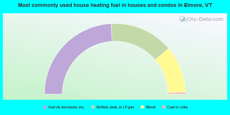
- 48.3%Fuel oil, kerosene, etc.
- 29.3%Bottled, tank, or LP gas
- 21.7%Wood
- 0.8%Coal or coke
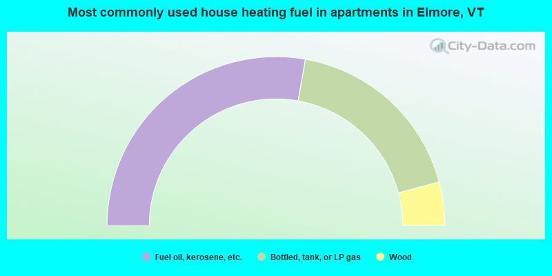
- 55.6%Fuel oil, kerosene, etc.
- 36.1%Bottled, tank, or LP gas
- 8.3%Wood
Elmore compared to Vermont state average:
- Unemployed percentage below state average.
- Black race population percentage significantly below state average.
- Hispanic race population percentage below state average.
- Renting percentage below state average.
- Length of stay since moving in significantly above state average.
- Number of rooms per house significantly below state average.
- House age significantly below state average.

|
Total of 4 patent applications in 2008-2024.