Edgerton, Missouri

Submit your own pictures of this city and show them to the world

  • OSM Map
  • General Map
  • Google Map
  • MSN Map
Population in 2022: 606 (0% urban, 100% rural).
Population change since 2000: +13.7%
 
Males: 298  (49.3%)
Females: 308  (50.7%)
Median resident age:

46.1 years
Missouri median age:

39.1 years

Zip codes: 64444.

Estimated median household income in 2022: $46,172 (it was $42,411 in 2000)
Edgerton:

$46,172
MO:

$64,811

Estimated per capita income in 2022: $32,822 (it was $18,444 in 2000)

Edgerton city income, earnings, and wages data

Estimated median house or condo value in 2022: $177,418 (it was $75,000 in 2000)
Edgerton:

$177,418
MO:

$221,200

Mean prices in 2022: all housing units: $344,366; detached houses: $354,523; townhouses or other attached units: $177,460; in 2-unit structures: $256,380; in 3-to-4-unit structures: $193,135; in 5-or-more-unit structures: $368,016; mobile homes: $73,944

Median gross rent in 2022: $581.

March 2022 cost of living index in Edgerton: 76.7 (low, U.S. average is 100)
Percentage of residents living in poverty in 2022: 20.6%
(18.0% for White Non-Hispanic residents, 12.5% for Hispanic or Latino residents, 79.2% for two or more races residents)

Compare current foreclosures near Edgerton, MO:

Check out more offers near Edgerton, MO.
Powered by Foreclosure.com
Settings
X
Data:
Loading data...
Based on 2000-2022 data
Loading data...

123
Hide US histogram
  • Races in Edgerton, MO (2022)
    • 46490.1%White alone
    • 244.7%Two or more races
    • 81.6%Hispanic
    • 61.2%American Indian alone

Races in Edgerton detailed stats: ancestries, foreign born residents, place of birth


According to our research of Missouri and other state lists, there were 4 registered sex offenders living in Edgerton, Missouri as of May 22, 2024.
The ratio of all residents to sex offenders in Edgerton is 142 to 1.


Crime rates in Edgerton by year

Type

2009

2010

2011

2012

2015

Murders
(per 100,000)
0
(0.0)
0
(0.0)
0
(0.0)
0
(0.0)
0
(0.0)
Rapes
(per 100,000)
0
(0.0)
0
(0.0)
0
(0.0)
0
(0.0)
0
(0.0)
Robberies
(per 100,000)
0
(0.0)
0
(0.0)
0
(0.0)
0
(0.0)
0
(0.0)
Assaults
(per 100,000)
7
(1,259)
1
(183.2)
4
(729.9)
0
(0.0)
0
(0.0)
Burglaries
(per 100,000)
3
(539.6)
4
(732.6)
1
(182.5)
1
(179.9)
0
(0.0)
Thefts
(per 100,000)
7
(1,259)
3
(549.5)
2
(365.0)
0
(0.0)
3
(523.6)
Auto thefts
(per 100,000)
0
(0.0)
0
(0.0)
1
(182.5)
0
(0.0)
0
(0.0)
Arson
(per 100,000)
0
(0.0)
1
(183.2)
0
(0.0)
0
(0.0)
0
(0.0)
City-Data.com crime index339.9109.9188.012.620.9

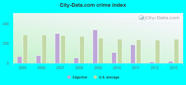
The City-Data.com crime index weighs serious crimes and violent crimes more heavily. Higher means more crime, U.S. average is 246.1. It adjusts for the number of visitors and daily workers commuting into cities.

Click on a table row to update graph
City-data.com crime index in Edgerton, MO

Crime rate in Edgerton detailed stats: murders, rapes, robberies, assaults, burglaries, thefts, arson
Recent articles from our blog. Our writers, many of them Ph.D. graduates or candidates, create easy-to-read articles on a wide variety of topics.
Edgerton, MO forum
Recent posts about Edgerton, Missouri on our local forum with over 2,400,000 registered users. Edgerton is mentioned 51 times on our forum:
Missouri Outlaw History  (3407 replies)
St. Louis to remove Confederate monument  (485 replies)
Interesting Missouri facts.  (1186 replies)
Wanted: Johnson Countians Willing To Talk About Kansas Now With Me  (204 replies)
Why do you live here?  (65 replies)
Sam Brownback and KS Commerce sending mass emails to MO Orgs  (51 replies)

Latest news from Edgerton, MO collected exclusively by city-data.com from local newspapers, TV, and radio stations

Ancestries: German (33.7%), Irish (16.7%), American (10.6%), English (5.3%), European (2.0%), French (1.6%).

Current Local Time: CST time zone

Incorporated in 1883

Elevation: 835 feet

Land area: 0.37 square miles.

Population density: 1,617 people per square mile   (low).

Edgerton, Missouri map

2 residents are foreign born

This city:

0.4%
Missouri:

2.7%

Median real estate property taxes paid for housing units with mortgages in 2022: $1,602 (0.7%)
Median real estate property taxes paid for housing units with no mortgage in 2022: $1,737 (1.3%)

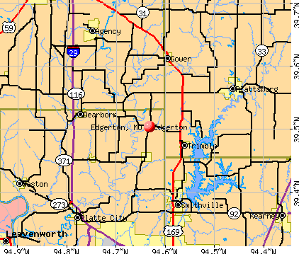
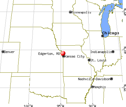
Nearest city with pop. 50,000+: St. Joseph, MO (20.7 miles , pop. 73,990).

Nearest city with pop. 200,000+: Kansas City, MO (29.9 miles , pop. 441,545).

Nearest city with pop. 1,000,000+: Chicago, IL (398.8 miles , pop. 2,896,016).

Nearest cities:

Ridgely, MO (1.9 miles),
Trimble, MO (2.0 miles ),
Camden Point, MO (2.6 miles ),
Dearborn, MO (2.7 miles ),
Gower, MO (2.8 miles ),
Smithville, MO (2.9 miles ),
Plattsburg, MO (3.2 miles ),
Agency, MO (3.4 miles )

Latitude: 39.50 N, Longitude: 94.63 W

Area code: 816

Distribution of median household income in Edgerton, MO in 2022
Distribution of house value in Edgerton, MO in 2022
Edgerton satellite photo by USGS

Single-family new house construction building permits:

  • 2021: 2 buildings, average cost: $285,000
  • 2019: 1 building, cost: $160,000
  • 2018: 3 buildings, average cost: $171,700
  • 2015: 4 buildings, average cost: $151,600
  • 2014: 3 buildings, average cost: $120,000
  • 2013: 1 building, cost: $550,000
  • 2012: 2 buildings, average cost: $302,500
  • 2011: 2 buildings, average cost: $132,500
  • 2008: 2 buildings, average cost: $80,000
  • 2007: 3 buildings, average cost: $160,000
  • 2006: 1 building, cost: $60,000
  • 2005: 3 buildings, average cost: $48,300
  • 2004: 2 buildings, average cost: $73,500
  • 2003: 1 building, cost: $105,000
  • 2002: 1 building, cost: $115,000
  • 2001: 2 buildings, average cost: $83,000
  • 1998: 4 buildings, average cost: $60,000
  • 1997: 1 building, cost: $95,000
Number of permits per 10,000 Edgerton, MO residents
Average permit cost in Edgerton, MO
Unemployment in December 2023:
Here:

2.4%
Missouri:

2.8%
Most common industries in Edgerton, MO (%)
Both Males Females
Most common industries in 2000
  • Accommodation & food services (11.0%)
  • Educational services (7.7%)
  • Construction (7.3%)
  • Health care (6.7%)
  • Food & beverage stores (5.7%)
  • Finance & insurance (5.7%)
  • Public administration (4.0%)
Most common industries for males in 2000
  • Construction (11.6%)
  • Accommodation & food services (7.9%)
  • Air transportation (6.1%)
  • Machinery (6.1%)
  • Other transportation, support activities, couriers (4.9%)
  • Truck transportation (4.9%)
  • Food & beverage stores (4.9%)
Most common industries for females in 2000
  • Accommodation & food services (14.7%)
  • Finance & insurance (12.5%)
  • Educational services (11.8%)
  • Health care (11.0%)
  • Food & beverage stores (6.6%)
  • Administrative & support & waste management services (5.1%)
  • Private households (4.4%)
Most common occupations in Edgerton, MO (%)
Both Males Females
Most common occupations in 2000
  • Vehicle and mobile equipment mechanics, installers, and repairers (5.3%)
  • Information and record clerks, except customer service representatives (5.0%)
  • Building and grounds cleaning and maintenance occupations (4.7%)
  • Cashiers (3.7%)
  • Other production occupations, including supervisors (3.7%)
  • Driver/sales workers and truck drivers (3.3%)
  • Cooks and food preparation workers (3.0%)
Most common occupations for males in 2000
  • Vehicle and mobile equipment mechanics, installers, and repairers (9.8%)
  • Other production occupations, including supervisors (5.5%)
  • Cashiers (4.9%)
  • Building and grounds cleaning and maintenance occupations (4.9%)
  • Driver/sales workers and truck drivers (4.9%)
  • Other management occupations, except farmers and farm managers (4.9%)
  • Material recording, scheduling, dispatching, and distributing workers (4.9%)
Most common occupations for females in 2000
  • Information and record clerks, except customer service representatives (9.6%)
  • Preschool, kindergarten, elementary, and middle school teachers (5.1%)
  • Other teachers, instructors, education, training, and library occupations (5.1%)
  • Financial clerks, except bookkeeping, accounting and auditing clerks (5.1%)
  • Registered nurses (5.1%)
  • Other office and administrative support workers, including supervisors (5.1%)
  • Secretaries and administrative assistants (5.1%)

Average climate in Edgerton, Missouri

Based on data reported by over 4,000 weather stations

Edgerton, Missouri average temperatures Edgerton, Missouri average precipitation Edgerton, Missouri humidity Edgerton, Missouri wind speed Edgerton, Missouri snowfall Edgerton, Missouri sunshine Edgerton, Missouri clear and cloudy days
Air pollution and air quality trends
(lower is better)
AQI CO NO2 SO2 Ozone PM10 PM2.5
Air Quality Index

Air Quality Index (AQI) level in 2022 was 79.2. This is about average.

City:

79.2
U.S.:

72.6
Carbon Monoxide Level

Carbon Monoxide (CO) [ppm] level in 2000 was 0.768. This is significantly worse than average. Closest monitor was 14.6 miles away from the city center.

City:

0.768
U.S.:

0.251
Nitrogen Dioxide Level

Nitrogen Dioxide (NO2) [ppb] level in 2010 was 5.32. This is about average. Closest monitor was 12.2 miles away from the city center.

City:

5.32
U.S.:

5.11
Sulfur Dioxide Level

Sulfur Dioxide (SO2) [ppb] level in 2005 was 2.90. This is significantly worse than average. Closest monitor was 14.6 miles away from the city center.

City:

2.90
U.S.:

1.51
Ozone Level

Ozone [ppb] level in 2022 was 31.9. This is about average. Closest monitor was 12.2 miles away from the city center.

City:

31.9
U.S.:

33.3
Particulate Matter Level

Particulate Matter (PM10) [µg/m3] level in 2022 was 30.2. This is significantly worse than average. Closest monitor was 20.4 miles away from the city center.

City:

30.2
U.S.:

19.2
Particulate Matter Level

Particulate Matter (PM2.5) [µg/m3] level in 2022 was 6.74. This is better than average. Closest monitor was 19.5 miles away from the city center.

City:

6.74
U.S.:

8.11

Tornado activity:

Edgerton-area historical tornado activity is slightly above Missouri state average. It is 101% greater than the overall U.S. average.

On 5/4/2003, a category F4 (max. wind speeds 207-260 mph) tornado 18.9 miles away from the Edgerton city center killed 2 people and injured 30 people and caused $48 million in damages.

On 5/7/1961, a category F4 tornado 19.2 miles away from the city center injured 12 people and caused between $500,000 and $5,000,000 in damages.

Earthquake activity:

Edgerton-area historical earthquake activity is significantly above Missouri state average. It is 461% greater than the overall U.S. average.

On 9/3/2016 at 12:02:44, a magnitude 5.8 (5.8 MW, Depth: 3.5 mi, Class: Moderate, Intensity: VI - VII) earthquake occurred 247.0 miles away from the city center
On 11/6/2011 at 03:53:10, a magnitude 5.7 (5.7 MW, Depth: 3.2 mi) earthquake occurred 298.6 miles away from Edgerton center
On 11/12/2014 at 21:40:00, a magnitude 4.9 (4.9 MW, Depth: 2.5 mi, Class: Light, Intensity: IV - V) earthquake occurred 223.8 miles away from the city center
On 11/7/2016 at 01:44:24, a magnitude 5.0 (5.0 MW, Depth: 2.8 mi) earthquake occurred 270.4 miles away from Edgerton center
On 2/13/2016 at 17:07:06, a magnitude 5.1 (5.1 MW, Depth: 5.2 mi) earthquake occurred 304.6 miles away from the city center
On 1/19/2020 at 19:08:42, a magnitude 4.5 (4.5 MW, Depth: 3.1 mi) earthquake occurred 207.2 miles away from Edgerton center
Magnitude types: moment magnitude (MW)

Natural disasters:

The number of natural disasters in Platte County (24) is greater than the US average (15).
Major Disasters (Presidential) Declared: 15
Emergencies Declared: 6

Causes of natural disasters: Floods: 16, Storms: 14, Tornadoes: 4, Winter Storms: 4, Winds: 2, Drought: 1, Hurricane: 1, Ice Storm: 1, Snowstorm: 1, Other: 1 (Note: some incidents may be assigned to more than one category).
Edgerton topographic map

Hospitals and medical centers near Edgerton:

  • GOLDEN LIVINGCENTER-SMITHVILLE (Nursing Home, about 10 miles away; SMITHVILLE, MO)
  • CLINTON CARE AND REHAB CENTER (Nursing Home, about 11 miles away; PLATTSBURG, MO)
  • OAKRIDGE OF PLATTSBURG (Nursing Home, about 11 miles away; PLATTSBURG, MO)
  • THREE RIVERS HOSPICE, INC (Hospital, about 13 miles away; PLATTE CITY, MO)
  • HILLVIEW NURSING AND REHAB (Nursing Home, about 13 miles away; PLATTE CITY, MO)
  • NEW MARK CARE CENTER (Nursing Home, about 15 miles away; KANSAS CITY, MO)
  • ASERACARE HOSPICE (Hospital, about 15 miles away; KANSAS CITY, MO)

Colleges/universities with over 2000 students nearest to Edgerton:

  • Grantham University (about 18 miles; Kansas City, MO; Full-time enrollment: 8,385)
  • Missouri Western State University (about 20 miles; Saint Joseph, MO; FT enrollment: 4,557)
  • Park University (about 22 miles; Parkville, MO; FT enrollment: 9,131)
  • Kansas City Kansas Community College (about 28 miles; Kansas City, KS; FT enrollment: 4,718)
  • Metropolitan Community College-Kansas City (about 31 miles; Kansas City, MO; FT enrollment: 12,834)
  • University of Missouri-Kansas City (about 33 miles; Kansas City, MO; FT enrollment: 10,544)
  • Rockhurst University (about 33 miles; Kansas City, MO; FT enrollment: 2,013)

Public elementary/middle school in Edgerton:

See full list of schools located in Edgerton

Points of interest:

Click to draw/clear city borders

Notable location: Edgerton - Trimble Fire Protection District Station 1 (A). Display/hide its location on the map

Cemetery: Standiford Cemetery (1). Display/hide its location on the map

Birthplace of: Jim Davis (actor) - Actor.

Platte County has a predicted average indoor radon screening level greater than 4 pCi/L (pico curies per liter) - Highest Potential

Drinking water stations with addresses in Edgerton and their reported violations in the past:

EDGERTON (Population served: 640, Purch surface water):
Past monitoring violations:
  • One routine major monitoring violation
Average household size:
This city:

2.6 people
Missouri:

2.5 people

Percentage of family households:
This city:

76.7%
Whole state:

65.3%

Percentage of households with unmarried partners:
This city:

6.2%
Whole state:

6.7%


Likely homosexual households (counted as self-reported same-sex unmarried-partner households)
  • Lesbian couples: 0.5% of all households
  • Gay men: 0.0% of all households

Banks with branches in Edgerton (2011 data):

  • U.S. Bank National Association: Edgerton Branch at 400 Frank Street, branch established on 1888/01/01. Info updated 2012/01/30: Bank assets: $330,470.8 mil, Deposits: $236,091.5 mil, headquarters in Cincinnati, OH, positive income, 3121 total offices, Holding Company: U.S. Bancorp

For population 15 years and over in Edgerton:

Marital status in Edgerton, MO
  • Never married: 19.9%
  • Now married: 38.4%
  • Separated: 1.9%
  • Widowed: 9.8%
  • Divorced: 30.1%

For population 25 years and over in Edgerton:

  • High school or higher: 93.8%
  • Bachelor's degree or higher: 15.3%
  • Graduate or professional degree: 3.7%
  • Unemployed: 2.3%
  • Mean travel time to work (commute): 40.2 minutes
Educational Attainment in 2022
School Enrollment by Level of School in 2022
Education Gini index (Inequality in education)
Here:

8.2
Missouri average:

11.1

Presidential Elections Results

Graphs represent county-level data. Detailed 2008 Election Results

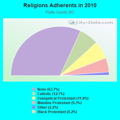
Religion statistics for Edgerton, MO (based on Platte County data)

Religions Adherents in 2010
Religions Adherents - Change between 2000 and 2010
ReligionAdherentsCongregations
Catholic11,3803
Evangelical Protestant10,56041
Mainline Protestant8,28121
Other1,9749
Black Protestant1851
Orthodox--
None56,942-
Source: Clifford Grammich, Kirk Hadaway, Richard Houseal, Dale E.Jones, Alexei Krindatch, Richie Stanley and Richard H.Taylor. 2012. 2010 U.S.Religion Census: Religious Congregations & Membership Study. Association of Statisticians of American Religious Bodies. Jones, Dale E., et al. 2002. Congregations and Membership in the United States 2000. Nashville, TN: Glenmary Research Center. Graphs represent county-level data

Food Environment Statistics:

Number of grocery stores: 13
Platte County:

1.53 / 10,000 pop.
Missouri:

1.88 / 10,000 pop.
Number of supercenters and club stores: 1
Here:

0.12 / 10,000 pop.
Missouri:

0.18 / 10,000 pop.
Number of convenience stores (no gas): 1
This county:

0.12 / 10,000 pop.
State:

0.60 / 10,000 pop.
Number of convenience stores (with gas): 24
Platte County:

2.83 / 10,000 pop.
Missouri:

4.34 / 10,000 pop.
Number of full-service restaurants: 73
This county:

8.62 / 10,000 pop.
Missouri:

7.37 / 10,000 pop.
Adult diabetes rate:
Platte County:

7.7%
State:

8.8%
Adult obesity rate:
Platte County:

29.0%
Missouri:

29.6%
Low-income preschool obesity rate:
This county:

15.6%
State:

13.5%

Health and Nutrition:

Healthy diet rate:
Edgerton:

47.3%
State:

50.9%

Average overall health of teeth and gums:
Here:

41.4%
Missouri:

48.6%

Average BMI:
This city:

29.1
Missouri:

28.7

People feeling badly about themselves:
Here:

23.6%
Missouri:

20.6%

People not drinking alcohol at all:
Here:

12.0%
State:

10.1%

Average hours sleeping at night:
Edgerton:

6.7
Missouri:

6.8

Overweight people:
Here:

34.8%
Missouri:

34.3%

General health condition:
Edgerton:

53.0%
Missouri:

57.5%

Average condition of hearing:
Here:

76.0%
Missouri:

79.3%

More about Health and Nutrition of Edgerton, MO Residents
Local government employment and payroll (March 2022)
Function Full-time employees Monthly full-time payroll Average yearly full-time wage Part-time employees Monthly part-time payroll
Sewerage 2$7,697$46,1821$1,971
Streets and Highways 2$8,524$51,1441$990
Water Supply 2$4,865$29,1901$1,681
Parks and Recreation 2$9,730$58,3801$853
Police Protection - Officers 0$0 2$829
Other Government Administration 0$0 7$1,316
Totals for Government 8$30,816$46,22413$7,640

Edgerton government finances - Expenditure in 2012 (per resident):

  • Current Operations - Water Utilities: $148,000 ($244.22)
    Central Staff Services: $84,000 ($138.61)
    Regular Highways: $76,000 ($125.41)
    Sewerage: $56,000 ($92.41)
    Police Protection: $25,000 ($41.25)
    Solid Waste Management: $22,000 ($36.30)
  • Total Salaries and Wages: $107,000 ($176.57)

Edgerton government finances - Revenue in 2012 (per resident):

  • Charges - Sewerage: $82,000 ($135.31)
    Solid Waste Management: $23,000 ($37.95)
    Other: $4,000 ($6.60)
  • Revenue - Water Utilities: $145,000 ($239.27)
  • State Intergovernmental - Highways: $21,000 ($34.65)
  • Tax - General Sales and Gross Receipts: $49,000 ($80.86)
    Property: $46,000 ($75.91)
    Public Utilities Sales: $46,000 ($75.91)
    Other License: $1,000 ($1.65)

Edgerton government finances - Cash and Securities in 2012 (per resident):

  • Other Funds - Cash and Securities: $86,000 ($141.91)

12.47% of this county's 2021 resident taxpayers lived in other counties in 2020 ($71,417 average adjusted gross income)

Here:

12.47%
Missouri average:

7.67%

0.05% of residents moved from foreign countries ($363 average AGI)
Platte County:

0.05%
Missouri average:

0.02%

Top counties from which taxpayers relocated into this county between 2020 and 2021:
from Clay County, MO  3.97% ($59,813 average AGI)
from Jackson County, MO  1.94% ($81,804)
from Johnson County, KS  0.77% ($102,644)


11.31% of this county's 2020 resident taxpayers moved to other counties in 2021 ($88,963 average adjusted gross income)

Here:

11.31%
Missouri average:

7.51%

0.05% of residents moved to foreign countries ($457 average AGI)
Platte County:

0.05%
Missouri average:

0.01%

Top counties to which taxpayers relocated from this county between 2020 and 2021:
to Clay County, MO  3.79% ($60,273 average AGI)
to Jackson County, MO  1.61% ($58,517)
to Johnson County, KS  0.74% ($78,528)

Strongest AM radio stations in Edgerton:

  • WHB (810 AM; 50 kW; KANSAS CITY, MO; Owner: UNION BROADCASTING, INC.)
  • KCMO (710 AM; 10 kW; KANSAS CITY, MO; Owner: SUSQUEHANNA KANSAS CITY PARTNERSHIP)
  • KKHK (1250 AM; 25 kW; KANSAS CITY, KS)
  • KSFT (1550 AM; 5 kW; ST. JOSEPH, MO; Owner: EAGLE RADIO, INC)
  • KFEQ (680 AM; 5 kW; ST. JOSEPH, MO; Owner: EAGLE RADIO, INC.)
  • KKLO (1410 AM; 5 kW; LEAVENWORTH, KS; Owner: CHARA COMMUNICATIONS, INC.)
  • KCCV (760 AM; daytime; 6 kW; OVERLAND PARK, KS; Owner: BOTT BROADCASTING COMPANY)
  • KCTE (1510 AM; daytime; 10 kW; INDEPENDENCE, MO; Owner: UNION BROADCASTING, INC.)
  • KXTR (1660 AM; 10 kW; KANSAS CITY, KS; Owner: ENTERCOM KANSAS CITY LICENSE, LLC)
  • KCSP (610 AM; 5 kW; KANSAS CITY, MO; Owner: ENTERCOM KANSAS CITY LICENSE, LLC)
  • KMBZ (980 AM; 5 kW; KANSAS CITY, MO; Owner: ENTERCOM KANSAS CITY LICENSE, LLC)
  • KPHN (1190 AM; 5 kW; KANSAS CITY, MO; Owner: ABC, INC.)
  • KOIL (1020 AM; 50 kW; PLATTSMOUTH, NE; Owner: WAITT RADIO, INC.)

Strongest FM radio stations in Edgerton:

  • KKJO-FM (105.5 FM; ST. JOSEPH, MO; Owner: EAGLE RADIO, INC)
  • KZPL (97.3 FM; LEE'S SUMMIT, MO; Owner: UNION FIRST BROADCASTING, LLC)
  • KFKF-FM (94.1 FM; KANSAS CITY, KS; Owner: INFINITY RADIO SUBSIDIARY OPERATIONS INC.)
  • KSRC (102.1 FM; KANSAS CITY, MO; Owner: INFINITY RADIO OPERATIONS INC.)
  • KCMO-FM (94.9 FM; KANSAS CITY, MO; Owner: SUSQUEHANNA KANSAS CITY PARTNERSHIP)
  • WDAF-FM (106.5 FM; LIBERTY, MO; Owner: ENTERCOM KANSAS CITY LICENSE, LLC)
  • KUDL (98.1 FM; KANSAS CITY, KS; Owner: ENTERCOM KANSAS CITY LICENSE, LLC)
  • KBEQ-FM (104.3 FM; KANSAS CITY, MO; Owner: INFINITY RADIO SUBSIDIARY OPERATIONS INC.)
  • KQRC-FM (98.9 FM; LEAVENWORTH, KS; Owner: ENTERCOM KANSAS CITY LICENSE, LLC)
  • KRBZ (96.5 FM; KANSAS CITY, MO; Owner: ENTERCOM KANSAS CITY LICENSE, LLC)
  • KYYS (99.7 FM; KANSAS CITY, MO; Owner: ENTERCOM KANSAS CITY LICENSE, LLC)
  • KMXV (93.3 FM; KANSAS CITY, MO; Owner: INFINITY RADIO OPERATIONS INC.)
  • KPRS (103.3 FM; KANSAS CITY, MO; Owner: CARTER BROADCAST GROUP, INC.)
  • KCUR-FM (89.3 FM; KANSAS CITY, MO; Owner: CURATORS OF UNIVERSITY OF MISSOURI)
  • KLJC (88.5 FM; KANSAS CITY, MO; Owner: CALVARY BIBLE COLLEGE)
  • KKFI (90.1 FM; KANSAS CITY, MO; Owner: MID-COAST RADIO PROJECT, INC.)
  • K220FX (91.9 FM; ST. JOSEPH, MO; Owner: CALVARY CHAPEL OF TWIN FALLS, INC.)

TV broadcast stations around Edgerton:

  • KTAJ (Channel 16; ST. JOSEPH, MO; Owner: TRINITY BROADCASTING NETWORK)
  • KMBC-TV (Channel 9; KANSAS CITY, MO; Owner: KMBC HEARST-ARGYLE TELEVISION, INC.)
  • KQTV (Channel 2; ST. JOSEPH, MO; Owner: NEXSTAR BROADCASTING OF THE MIDWEST, INC.)
  • KCTV (Channel 5; KANSAS CITY, MO; Owner: MEREDITH CORPORATION)
  • KCPT (Channel 19; KANSAS CITY, MO; Owner: PUBLIC TELEVISION 19, INC.)
  • KSMO-TV (Channel 62; KANSAS CITY, MO; Owner: KSMO LICENSEE, INC.)
  • KCWE (Channel 29; KANSAS CITY, MO; Owner: KCWE-TV, INC.)
  • KSHB-TV (Channel 41; KANSAS CITY, MO; Owner: SCRIPPS HOWARD BROADCASTING COMPANY)
  • WDAF-TV (Channel 4; KANSAS CITY, MO; Owner: WDAF LICENSE, INC.)
  • KPXE (Channel 50; KANSAS CITY, MO; Owner: PAXSON KANSAS CITY LICENSE, INC.)
  • KMCI (Channel 38; LAWRENCE, KS; Owner: SCRIPPS HOWARD BROADCASTING COMPANY)
  • K48FS (Channel 48; KANSAS CITY, MO; Owner: WORD OF GOD FELLOWSHIP, INC.)
  • K35CT (Channel 35; KANSAS CITY, MO; Owner: WORD OF GOD FELLOWSHIP, INC.)

Edgerton fatal accident list:

Jun 28, 2006 07:36 PM, Sr-B, Lat: 39.483270, Lon: -94.638210, Vehicles: 1, Persons: 1, Fatalities: 1, Drunk persons involved: 1
  • National Bridge Inventory (NBI) Statistics
  • 10Number of bridges
  • 335ft / 102mTotal length
  • $1,232,000Total costs
  • 3,771Total average daily traffic
  • 357Total average daily truck traffic
  • 6,164Total future (year 2040) average daily traffic
New bridges in Edgerton, MO - historical statistics
  • New bridges - historical statistics
  • 11900-1909
  • 11920-1929
  • 21960-1969
  • 11970-1979
  • 42000-2009
  • 12010-2019
See full National Bridge Inventory statistics for Edgerton, MO

FCC Registered Cell Phone Towers:

1
  • 18010 Nw County Line Rd (Lat: 39.426167 Lon: -94.602694), Type: Tower, Structure height: 89.6 m, Overall height: 92.7 m, Call Sign: KNKA337
    Assigned Frequencies: 869.040 MHz, 869.040 MHz, 824.040 MHz, 824.040 MHz, 890.010 MHz, 890.010 MHz, 845.010 MHz, 845.010 MHzGrant Date: 01/05/2016, Expiration Date: 02/09/2026, Certifier: Gregory M RomanoRegistrant: Verizon, 1300 I St Nw - Suite 500 East, Washington, DC 20005, Phone: (202) 515-2453, Email:


FCC Registered Antenna Towers:

6
  • Lottie L Thompson, 18010 Nw County Line Rd (Lat: 39.426167 Lon: -94.602694), Type: 92.7, Overall height: 89.6 m, Registrant: American Towers, Inc., Schau-mburg, Phone: (847) 240-1508

  • Lottie L Thompson, 18010 Nw County Line Rd (Lat: 39.426167 Lon: -94.602694), Type: 92.7, Overall height: 89.6 m, Registrant: American Towers, Inc., Schau-mburg, Phone: (847) 240-1508

  • Mehran Nazari, Adjacent To 3805 Malcolm Lake Road (Lat: 39.469833 Lon: -94.620611), Type: 100.6, Overall height: 91.4 m, Registrant: Mid-America Regional Council (Marc), Kansa-s City

  • Mehran Nazari, Adjacent To 3805 Malcolm Lake Road (Lat: 39.469833 Lon: -94.620611), Type: 100.6, Overall height: 91.4 m, Registrant: Mid-America Regional Council (Marc), Kansa-s City

  • KIM E HULL, Adjacent To 3805 Malcolm Lake Road (Lat: 39.469833 Lon: -94.620611), Type: 100.6, Overall height: 91.4 m, Registrant: Mid-America Regional Council (Marc), Bwhitmer@marc.Org, , Kansa-s City, Phone: (816) 701-8251

  • Bridget Carter, 18010 Nw County Line Rd (Lat: 39.426167 Lon: -94.602694), Type: 92.7, Structure height: 29165 m, Overall height: 89.6 m, Registrant: American Towers, Inc., Schau-mburg, Phone: (847) 240-1508


FCC Registered Broadcast Land Mobile Towers:

3
  • 1 Mi N Of Int Mo Crs Kk & B 1/3 Mi E On Gravel Rd S Side (Lat: 39.416667 Lon: -94.635222), Call Sign: KNEM784, Licensee ID: L00052060,
    Assigned Frequencies: 153.035 MHz, Grant Date: 03/27/2003, Expiration Date: 04/14/2013, Cancellation Date: 06/15/2013, Registrant: Keith Taylor, 6345 Little Platte Rd, Edgerton, MO 64444, Phone: (816) 532-0737

  • Adjacent To 3805 Malcolm Lake Road (Lat: 39.469833 Lon: -94.620611), Type: Ltower, Structure height: 91.4 m, Overall height: 100.6 m, Call Sign: WQGD278,
    Assigned Frequencies: 453.212 MHz, 453.462 MHz, 453.712 MHz, Grant Date: 10/08/2016, Expiration Date: 12/14/2026, Certifier: Nikki Moss, Registrant: Commenco Inc, 4901 Bristol Avenue, Kansas City, MO 64129, Phone: (816) 753-2166, Fax: (816) 753-3688, Email:

  • TRIMBLE, Adjacent To 3805 Malcolm Lake Road (Lat: 39.469833 Lon: -94.620611), Type: Tower, Structure height: 91.4 m, Overall height: 100.6 m, Call Sign: WQKE989,
    Assigned Frequencies: 460.437 MHz, 465.050 MHz, Grant Date: 02/05/2019, Expiration Date: 04/24/2029, Certifier: Kim E Hull, Registrant: Missouri State Highway Patrol, 1510 E Elm St, Jefferson City, MO 65102-0568, Phone: (573) 526-6107, Email:


FCC Registered Microwave Towers:

6
  • TRIMBLE, Adjacent To 3805 Malcolm Lake Road (Lat: 39.469833 Lon: -94.620611), Type: Ltower, Structure height: 91.4 m, Overall height: 100.6 m, Call Sign: WQHJ742,
    Assigned Frequencies: 5974.85 MHz, 6004.50 MHz, 5945.20 MHz, 5945.20 MHz, 5945.20 MHz, 5945.20 MHz, 5945.20 MHz, 5945.20 MHz, 5945.20 MHz, 5945.20 MHz... (+31 more), Grant Date: 05/31/2017, Expiration Date: 08/16/2027, Certifier: Reggie J Chandra, Registrant: Commenco, LLC, 4901 Bristol Ave, Kansas City, MO 64129, Phone: (816) 753-2166, Fax: (816) 753-3688, Email:

  • TRIMBLE, Adjacent To 3805 Malcolm Lake Road (Lat: 39.469833 Lon: -94.620611), Type: Gtower, Structure height: 91.4 m, Overall height: 100.6 m, Call Sign: WQPZ673,
    Assigned Frequencies: 6093.45 MHz, Grant Date: 09/15/2022, Expiration Date: 09/28/2032, Certifier: Mark Owen, Registrant: Midwest Mobile Radio Service Inc., 812 South 10th Street, Saint Joseph, MO 64506, Phone: (816) 279-2065, Fax: (816) 233-8862, Email:

  • A5C0077A, 13901 Se Windecker Rd. (Lat: 39.537306 Lon: -94.610861), Type: Gtower, Structure height: 54.9 m, Call Sign: WQWC339,
    Assigned Frequencies: 11305.0 MHz, 11305.0 MHz, 11305.0 MHz, 11305.0 MHz, 11305.0 MHz, 11305.0 MHz, 11305.0 MHz, 11305.0 MHz, Grant Date: 07/15/2015, Expiration Date: 07/15/2025, Cancellation Date: 12/22/2020, Certifier: David Werblow, Registrant: T-Mobile Usa, Inc., 12920 Se 38th Street, Bellevue, WA 98006, Phone: (425) 383-8401, Fax: (425) 383-4040, Email:

  • A5C0078A, 18010 Nw County Line Rd (Lat: 39.426167 Lon: -94.602694), Type: Gtower, Structure height: 89.6 m, Overall height: 92.7 m, Call Sign: WQWC340,
    Assigned Frequencies: 10815.0 MHz, 10815.0 MHz, 10815.0 MHz, 10815.0 MHz, 10815.0 MHz, 10815.0 MHz, 10815.0 MHz, 10815.0 MHz, Grant Date: 07/15/2015, Expiration Date: 07/15/2025, Cancellation Date: 12/22/2020, Certifier: David Werblow, Registrant: T-Mobile Usa, Inc., 12920 Se 38th Street, Bellevue, WA 98006, Phone: (425) 383-8401, Fax: (425) 383-4040, Email:

  • PLTTMOAA, 18010 Nw County Line Rd (Lat: 39.426167 Lon: -94.602694), Type: Ltower, Structure height: 89.6 m, Overall height: 92.7 m, Call Sign: WRNV591, Licensee ID: L02347278,
    Assigned Frequencies: 10995.0 MHz, 11075.0 MHz, 10995.0 MHz, 11075.0 MHz, 10995.0 MHz, 11075.0 MHz, 10995.0 MHz, 11075.0 MHz, 10995.0 MHz, 11075.0 MHz... (+10 more), Grant Date: 08/28/2021, Expiration Date: 08/28/2031, Certifier: Dave Mills, Registrant: Wisper Isp, LLC, 9711 Fuesser Road, Mascoutah, IL 62258, Phone: (618) 206-4190, Email:

  • A5C0077A, Access Road Off Se Windecker Rd (Lat: 39.537306 Lon: -94.610861), Type: Gtower, Structure height: 54.9 m, Call Sign: WRUM907,
    Assigned Frequencies: 11645.0 MHz, 11645.0 MHz, 11645.0 MHz, 11645.0 MHz, 11645.0 MHz, 11645.0 MHz, 11645.0 MHz, 11645.0 MHz, 11645.0 MHz, 11645.0 MHz, 11645.0 MHz, Grant Date: 09/13/2022, Expiration Date: 09/13/2032, Cancellation Date: 02/27/2024, Certifier: Jenny Knopf, Registrant: T-Mobile Usa, Inc., 12920 Se 38th Street, Bellevue, WA 98006, Phone: (425) 383-8401, Fax: (425) 383-4040, Email:


FCC Registered Amateur Radio Licenses:

10 (See the full list of FCC Registered Amateur Radio Licenses in Edgerton)

FAA Registered Aircraft:

7
  • Aircraft: PIPER PA-34-200T (Category: Land, Engines: 2, Seats: 7, Weight: Up to 12,499 Pounds, Speed: 105 mph), Engine: CONT MOTOR TSIO-360 SER (225 HP) (Reciprocating)
    N-Number: 1070X, N1070X, N-1070X, Serial Number: 34-7570199, Year manufactured: 1975, Airworthiness Date: 05/07/1975, Certificate Issue Date: 05/17/2016
    Registrant (LLC): Mosby Group LLC, 8460 Highway E, Edgerton, MO 64444
  • Aircraft: ROBINSON HELICOPTER COMPANY R44 II (Category: Land, Seats: 4, Weight: Up to 12,499 Pounds), Engine: LYCOMING IO-540-AE1A5 (260 HP) (Reciprocating)
    N-Number: 570GG, N570GG, N-570GG, Serial Number: 13790, Year manufactured: 2015, Airworthiness Date: 02/12/2015, Certificate Issue Date: 10/16/2020
    Registrant (LLC): Glenwood Farm LLC, 8460 Highway E, Edgerton, MO 64444
  • Aircraft: CABLE CLYDE M RV-8 (Category: Land, Seats: 2, Weight: Up to 12,499 Pounds), Engine: AEROSPORT IO375 (180 HP) (4 Cycle)
    N-Number: 813CC, N813CC, N-813CC, Serial Number: 83098, Year manufactured: 2010, Airworthiness Date: 11/26/2010, Certificate Issue Date: 07/09/2012
    Registrant (Corporation): Todd P Graves Inc, 8460 Highway E, Edgerton, MO 64444
  • Aircraft: SOCATA TBM 700 (Category: Land, Seats: 7, Weight: Up to 12,499 Pounds), Engine: P&W CANADA PT6A66D (850 HP) (Turbo-prop)
    N-Number: 930RA, N930RA, N-930RA, Serial Number: 1146, Year manufactured: 2016, Airworthiness Date: 10/24/2016, Certificate Issue Date: 03/06/2019
    Registrant (Co-Owned): Group LLC Mosby, 8460 Highway E, Edgerton, MO 64444, Other Owners: Enterprises LLC 22
  • Aircraft: CESSNA 195 (Category: Land, Seats: 5, Weight: Up to 12,499 Pounds, Speed: 146 mph), Engine: JACOBS R755B SERIES (275 HP) (Reciprocating)
    N-Number: 9318A, N9318A, N-9318A, Serial Number: 7397, Year manufactured: 1949, Airworthiness Date: 05/31/1956, Certificate Issue Date: 03/10/2000
    Registrant (Co-Owned): Michael Todd Smith, 7415 Dicks Creek Rd, Edgerton, MO 64444, Other Owners: Jane Smith
  • Aircraft: PIPER PA-18A 150 (Category: Land, Weight: Up to 12,499 Pounds, Speed: 97 mph), Engine: LYCOMING 0-320 SERIES (180 HP) (Reciprocating)
    N-Number: 9879D, N9879D, N-9879D, Serial Number: 18-6901, Year manufactured: 1959, Airworthiness Date: 10/24/2002, Certificate Issue Date: 10/13/2011
    Registrant (LLC): Glenwood Farm LLC, C/O Todd Graves / 8460 Highway E, Edgerton, MO 64444
  • Aircraft: SOCATA TBM 700 (Category: Land, Seats: 7, Weight: Up to 12,499 Pounds), Engine: P&W CANADA PT6A-64 (700 HP) (Turbo-prop)
    N-Number: 703BM, N703BM, N-703BM, Serial Number: 256, Year manufactured: 2003, Airworthiness Date: 12/21/2004, Certificate Issue Date: 01/16/2018
    Registrant (Co-Owned): Group LLC Mosby, 8460 Highway E, Edgerton, MO 64444, Other Owners: Enterprises LLC 22
    Deregistered: Cancel Date: 06/18/2020, Exported to: Guernsey

Home Mortgage Disclosure Act Aggregated Statistics For Year 2009
(Based on 1 partial tract)
C) Refinancings
NumberAverage Value
LOANS ORIGINATED1$127,240
APPLICATIONS APPROVED, NOT ACCEPTED0$0
APPLICATIONS DENIED0$0
APPLICATIONS WITHDRAWN0$0
FILES CLOSED FOR INCOMPLETENESS0$0
Choose year:  2009 2006 2005 2004 2003 2002 2001

Detailed HMDA statistics for the following Tracts: 0306.00

2002 - 2018 National Fire Incident Reporting System (NFIRS) incidents

    Fire incident distribution by year Based on the data from the years 2002 - 2018 the average number of fire incidents per year is 12. The highest number of reported fires - 25 took place in 2012, and the least - 0 in 2017. The data has a decreasing trend.
    Fire incident types in Edgerton, MO When looking into fire subcategories, the most reports belonged to: Outside Fires (62.1%), and Structure Fires (21.7%).

    • Fire incident types reported to NFIRS in Edgerton, MO
    • 12362.1%Outside Fires
    • 4321.7%Structure Fires
    • 2110.6%Mobile Property/Vehicle Fires
    • 115.6%Other
See full National Fire Incident Reporting System statistics for Edgerton, MO
Most common first names in Edgerton, MO among deceased individuals
NameCountLived (average)
John1278.9 years
Mary1076.2 years
Robert1073.4 years
James879.1 years
Ruth873.5 years
William873.0 years
Charles777.7 years
Clarence672.6 years
Mabel579.8 years
Margaret579.0 years
Most common last names in Edgerton, MO among deceased individuals
Last nameCountLived (average)
Boydston1276.5 years
Miller1081.3 years
Jackson888.1 years
Shafer878.8 years
Heath879.9 years
Stubbs775.6 years
Smith773.1 years
Cook773.0 years
Johnson776.8 years
Foster778.3 years
Houses and condos Apartments
Most commonly used house heating fuel in houses and condos in Edgerton, MO
  • 63.5%Utility gas
  • 19.8%Electricity
  • 10.2%Bottled, tank, or LP gas
  • 3.6%Wood
  • 3.0%Fuel oil, kerosene, etc.
Most commonly used house heating fuel in apartments in Edgerton, MO
  • 84.7%Utility gas
  • 15.3%Electricity


Edgerton compared to Missouri state average:

  • Unemployed percentage significantly below state average.
  • Black race population percentage significantly below state average.
  • Hispanic race population percentage significantly below state average.
  • Median age above state average.
  • Foreign-born population percentage significantly below state average.
  • Renting percentage below state average.
  • Length of stay since moving in significantly above state average.
  • House age above state average.
  • Number of college students significantly below state average.
There are 2 pilots and 7 other airmen in this city.
Cost of Living Calculator
Top Patent Applicants
  • Mark B. Fisher (2)
  • Thomas J. Sweet (1)

Total of 3 patent applications in 2008-2024.