East Tehama, California
Submit your own pictures of this place and show them to the world
- OSM Map
- General Map
- Google Map
- MSN Map

| Males: 2,146 | |
| Females: 2,044 |
| Median resident age: | 39.1 years |
| California median age: | 33.3 years |
| East Tehama: | $50,802 |
| CA: | $91,551 |
Estimated per capita income in 2022: $25,409 (it was $13,514 in 2000)
East Tehama CCD income, earnings, and wages data
Estimated median house or condo value in 2022: $291,314 (it was $82,600 in 2000)
| East Tehama: | $291,314 |
| CA: | $715,900 |
Mean prices in 2022: all housing units: $341,623; detached houses: $378,867; townhouses or other attached units: $281,544; in 5-or-more-unit structures: $207,517; mobile homes: $211,680; occupied boats, rvs, vans, etc.: $84,243
Detailed information about poverty and poor residents in East Tehama, CA


- 2,99877.4%White alone
- 69017.8%Hispanic
- 721.9%American Indian alone
- 571.5%Two or more races
- 340.9%Black alone
- 100.3%Asian alone
- 70.2%Native Hawaiian and Other
Pacific Islander alone - 30.08%Other race alone

 Recent articles from our blog. Our writers, many of them Ph.D. graduates or candidates, create easy-to-read articles on a wide variety of topics.
Current Local Time: PST time zone
Land area: 1200.4 square miles.
Population density: 3.5 people per square mile (very low).

| East Tehama CCD: | 0.7% ($608) |
| California: | 0.8% ($1,564) |
Nearest city with pop. 50,000+: Chico, CA  (35.7 miles , pop. 59,954).
Nearest city with pop. 200,000+: Sacramento, CA (118.4 miles , pop. 407,018).
Nearest city with pop. 1,000,000+: Los Angeles, CA (465.4 miles , pop. 3,694,820).
Nearest cities:
), ), Latitude: 40.25 N, Longitude: 121.76 W
Area code commonly used in this area: 530


| Here: | 6.4% |
| California: | 5.1% |

- Agriculture, forestry, fishing & hunting (14.0%)
- Wood products (8.8%)
- Accommodation & food services (7.3%)
- Educational services (7.2%)
- Construction (6.6%)
- Health care (5.5%)
- Administrative & support & waste management services (4.9%)

- Agriculture, forestry, fishing & hunting (20.9%)
- Wood products (14.3%)
- Construction (11.4%)
- Accommodation & food services (6.8%)
- Administrative & support & waste management services (5.0%)
- Repair & maintenance (4.3%)
- Utilities (4.2%)

- Educational services (14.0%)
- Health care (12.5%)
- Finance & insurance (8.3%)
- Accommodation & food services (7.9%)
- Social assistance (5.3%)
- Agriculture, forestry, fishing & hunting (4.7%)
- Administrative & support & waste management services (4.7%)

- Agricultural workers, including supervisors (7.0%)
- Other production occupations, including supervisors (6.1%)
- Other management occupations, except farmers and farm managers (4.6%)
- Driver/sales workers and truck drivers (4.3%)
- Laborers and material movers, hand (3.5%)
- Material recording, scheduling, dispatching, and distributing workers (3.5%)
- Building and grounds cleaning and maintenance occupations (3.4%)

- Agricultural workers, including supervisors (10.7%)
- Other production occupations, including supervisors (9.2%)
- Driver/sales workers and truck drivers (7.4%)
- Construction traders workers except carpenters, electricians, painters, plumbers, and construction laborers (5.6%)
- Vehicle and mobile equipment mechanics, installers, and repairers (5.2%)
- Electrical equipment mechanics and other installation, maintenance, and repair workers, including supervisors (4.6%)
- Building and grounds cleaning and maintenance occupations (4.3%)

- Material recording, scheduling, dispatching, and distributing workers (6.6%)
- Other management occupations, except farmers and farm managers (5.7%)
- Other office and administrative support workers, including supervisors (5.1%)
- Counselors, social workers, and other community and social service specialists (4.9%)
- Health technologists and technicians (4.5%)
- Waiters and waitresses (4.5%)
- Other teachers, instructors, education, training, and library occupations (4.5%)
Average climate in East Tehama, California
Based on data reported by over 4,000 weather stations


(lower is better)

Air Quality Index (AQI) level in 2023 was 50.2. This is significantly better than average.
| City: | 50.2 |
| U.S.: | 72.6 |

Ozone [ppb] level in 2023 was 41.2. This is worse than average. Closest monitor was 22.0 miles away from the city center.
| City: | 41.2 |
| U.S.: | 33.3 |
Earthquake activity:
East Tehama-area historical earthquake activity is significantly above California state average. It is 5643% greater than the overall U.S. average.On 4/18/1906 at 13:12:21, a magnitude 7.9 (7.9 UK, Class: Major, Intensity: VIII - XII) earthquake occurred 169.5 miles away from East Tehama center, causing $524,000,000 total damage
On 1/31/1922 at 13:17:28, a magnitude 7.6 (7.6 UK) earthquake occurred 202.0 miles away from the city center
On 4/25/1992 at 18:06:04, a magnitude 7.2 (6.3 MB, 7.1 MS, 7.2 MW, 7.1 MW, Depth: 9.4 mi) earthquake occurred 122.0 miles away from the city center, causing $75,000,000 total damage
On 10/3/1915 at 06:52:48, a magnitude 7.6 (7.6 UK) earthquake occurred 225.0 miles away from East Tehama center
On 11/8/1980 at 10:27:34, a magnitude 7.2 (6.2 MB, 7.2 MS, 7.2 MW, 7.0 ML) earthquake occurred 145.9 miles away from East Tehama center
On 1/22/1923 at 09:04:18, a magnitude 7.2 (7.2 UK) earthquake occurred 188.6 miles away from the city center
Magnitude types: body-wave magnitude (MB), local magnitude (ML), surface-wave magnitude (MS), moment magnitude (MW)
Natural disasters:
The number of natural disasters in Tehama County (19) is greater than the US average (15).Major Disasters (Presidential) Declared: 12
Emergencies Declared: 3
Causes of natural disasters: Floods: 13, Storms: 7, Winter Storms: 6, Landslides: 4, Fires: 2, Mudslides: 2, Drought: 1, Freeze: 1, Heavy Rain: 1, Hurricane: 1, Tornado: 1, Other: 1 (Note: some incidents may be assigned to more than one category).
Colleges/universities with over 2000 students nearest to East Tehama:
- California State University-Chico (about 37 miles; Chico, CA; Full-time enrollment: 14,838)
- Shasta College (about 40 miles; Redding, CA; FT enrollment: 5,645)
- Butte College (about 43 miles; Oroville, CA; FT enrollment: 8,649)
- Yuba College (about 79 miles; Marysville, CA; FT enrollment: 4,737)
- Sierra College (about 106 miles; Rocklin, CA; FT enrollment: 11,488)
- Mendocino College (about 108 miles; Ukiah, CA; FT enrollment: 2,263)
- Universal Technical Institute of Northern California Inc (about 112 miles; Sacramento, CA; FT enrollment: 3,193)
Points of interest:
Notable locations in East Tehama: South Antelope Campground (A), Tent Camp (B), Childs Ranch (C), Battle Creek Rod and Gun Club (D), Inskip Powerhouse (E), Willow Spring Campground (F), Willards Camp (G), Stephens Ranch (H), Shults Ranch (I), Wilson Ranch (J), Wild Horse Corral (K), Transfer (L), Mount Lassen Trout Farm (M), Brokenshire Picnic Area (N), Lassen Volcanic National Park Headquarters (O), Manton Fire Control Station (P), Turner Mountain Lookout (Q), Mill Creek Campground (R), Hole in the Ground Campground (S), Lost Creek Maintenance Station (T). Display/hide their locations on the map
Cemetery: Carter Cemetery (1). Display/hide its location on the map
Lakes, reservoirs, and swamps: Patricia Lake (A), Forest Lake (B), Finley Lake (C), Turner Lake (D), Wilson Lake (E), Diamond Lake (F), Hog Lake (G), Conard Lake (H). Display/hide their locations on the map
Streams, rivers, and creeks: Brush Creek (A), Cameron Creek (B), Campbell Creek (C), China Slough (D), Cottonwood Creek (E), Delaney Slough (F), Dry Creek (G), Flume Creek (H), Hoag Slough (I). Display/hide their locations on the map
Parks in East Tehama include: Mill Creek Park (1), Tehama State Wildlife Area (2), Tehama County River Park (3). Display/hide their locations on the map
| This place: | 2.5 people |
| California: | 2.9 people |
| This place: | 65.6% |
| Whole state: | 68.7% |
| This place: | 6.9% |
| Whole state: | 7.2% |
Likely homosexual households (counted as self-reported same-sex unmarried-partner households)
- Lesbian couples: 0.1% of all households
- Gay men: 0.1% of all households
| This place: | 19.0% |
| Whole state: | 14.2% |
| This place: | 9.2% |
| Whole state: | 6.3% |
People in group quarters in East Tehama in 2010:
- 87 people in state prisons
- 50 people in other noninstitutional facilities
- 32 people in group homes intended for adults
People in group quarters in East Tehama in 2000:
- 108 people in state prisons
- 29 people in other noninstitutional group quarters
- 25 people in religious group quarters
- 8 people in nursing homes
- 4 people in homes for the mentally retarded
- 3 people in agriculture workers' dormitories on farms
For population 15 years and over in East Tehama:

- Never married: 21.8%
- Now married: 58.4%
- Separated: 1.0%
- Widowed: 7.9%
- Divorced: 11.9%
For population 25 years and over in East Tehama:
- High school or higher: 76.0%
- Bachelor's degree or higher: 9.6%
- Graduate or professional degree: 2.9%
- Unemployed: 12.4%
- Mean travel time to work (commute): 22.9 minutes


| Here: | 11.9 |
| California average: | 16.1 |
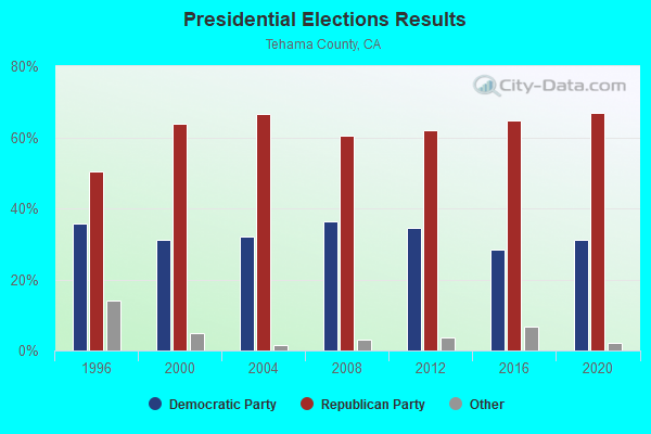
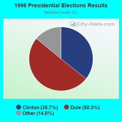

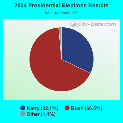
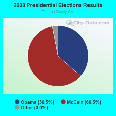
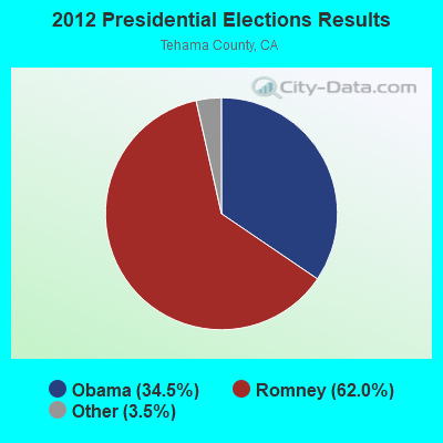
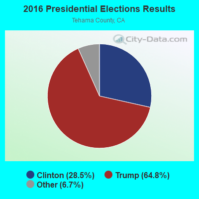

Graphs represent county-level data. Detailed 2008 Election Results
Religion statistics for East Tehama, CA (based on Tehama County data)
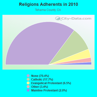
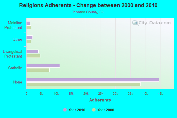
| Religion | Adherents | Congregations |
|---|---|---|
| Catholic | 11,243 | 3 |
| Evangelical Protestant | 4,100 | 39 |
| Other | 2,130 | 6 |
| Mainline Protestant | 1,280 | 11 |
| Orthodox | 20 | 1 |
| None | 44,690 | - |
Food Environment Statistics:
| Tehama County: | 1.80 / 10,000 pop. |
| California: | 2.14 / 10,000 pop. |
| This county: | 0.98 / 10,000 pop. |
| California: | 0.62 / 10,000 pop. |
| Tehama County: | 3.12 / 10,000 pop. |
| State: | 1.49 / 10,000 pop. |
| Tehama County: | 4.76 / 10,000 pop. |
| State: | 7.42 / 10,000 pop. |
| Tehama County: | 8.4% |
| State: | 7.3% |
| Tehama County: | 25.5% |
| State: | 21.3% |
| This county: | 13.3% |
| California: | 17.9% |
Strongest AM radio stations in East Tehama:
- KKOH (780 AM; 50 kW; RENO, NV; Owner: CITADEL BROADCASTING COMPANY)
- KNRO (1670 AM; 10 kW; REDDING, CA; Owner: REGENT LICENSEE OF REDDING, INC.)
- KFBK (1530 AM; 50 kW; SACRAMENTO, CA; Owner: AMFM RADIO LICENSES, L.L.C.)
- KFIA (710 AM; 25 kW; CARMICHAEL, CA; Owner: VISTA BROADCASTING INC.)
- KVIP (540 AM; 2 kW; REDDING, CA; Owner: PACIFIC CASCADE COMMUNICATIONS CORP.)
- KCBS (740 AM; 50 kW; SAN FRANCISCO, CA; Owner: INFINITY BROADCASTING OPERATIONS, INC.)
- KPAY (1290 AM; 5 kW; CHICO, CA; Owner: CAPSTAR TX LIMITED PARTNERSHIP)
- KHTK (1140 AM; 50 kW; SACRAMENTO, CA; Owner: INFINITY RADIO SUBSIDIARY OPERATIONS INC.)
- KSTE (650 AM; 25 kW; RANCHO CORDOVA, CA; Owner: AMFM RADIO LICENSES, L.L.C.)
- KCBC (770 AM; 50 kW; RIVERBANK, CA; Owner: KIERTRON, INC.)
- KNBR (680 AM; 50 kW; SAN FRANCISCO, CA; Owner: KNBR LICO, INC.)
- KTRB (860 AM; 50 kW; MODESTO, CA; Owner: PAPPAS RADIO OF CALIFORNIA, A CALIFORNIA LIMITED PARTNERSHIP)
- KGO (810 AM; 50 kW; SAN FRANCISCO, CA; Owner: KGO-AM RADIO, INC.)
Strongest FM radio stations in East Tehama:
- KLVB-FM (102.7 FM; RED BLUFF, CA; Owner: EDUCATIONAL MEDIA FOUNDATION)
- KRDG (105.3 FM; SHINGLETOWN, CA; Owner: REGENT LICENSEE OF REDDING, INC.)
- KKXS (96.1 FM; SHINGLETOWN, CA; Owner: RESULTS RADIO LICENSEE, LLC)
- KLVC (88.3 FM; MAGALIA, CA; Owner: EDUCATIONAL MEDIA FOUNDATION)
- K216CF (91.1 FM; CHICO, CA; Owner: YOUR CHRISTIAN COMPANION NETWORK, INC.)
- KZAP (96.7 FM; PARADISE, CA; Owner: REGENT LICENSEE OF CHICO, INC.)
- K205EJ (88.9 FM; CHESTER, CA; Owner: CALVARY CHAPEL OF TWIN FALLS, INC.)
- KHSL-FM (103.5 FM; PARADISE, CA; Owner: CAPSTAR TX LIMITED PARTNERSHIP)
- KCHO (91.7 FM; CHICO, CA; Owner: UNIV. FOUNDATION/CA. ST. UNIV. CHICO)
- KMXI (95.1 FM; CHICO, CA; Owner: CAPSTAR TX LIMITED PARTNERSHIP)
- KTOR (99.7 FM; WESTWOOD, CA; Owner: SIERRA RADIO, INC.)
- KFMF (93.9 FM; CHICO, CA; Owner: REGENT LICENSEE OF CHICO, INC)
- KBNF (98.9 FM; CHESTER, CA; Owner: CAROUSEL BROADCASTING, INC.)
- K209AY (89.7 FM; CHESTER, CA; Owner: THE UNIV. FOUND. CA STATE UNIVERSITY)
- KHRD (103.1 FM; WEAVERVILLE, CA; Owner: RESULTS RADIO LICENSEE, LLC)
- KNCQ (97.3 FM; REDDING, CA; Owner: RESULTS RADIO OF REDDING, LLC)
- KHGQ (100.3 FM; QUINCY, CA; Owner: KEILY MILLER)
- K225AJ (92.9 FM; BURNEY/REDDING, CA; Owner: CALVARY CHAPEL OF TWIN FALLS, INC.)
- KNCA (89.7 FM; BURNEY, CA; Owner: OREGON STATE BOARD OF HIGHER ED.)
- KHJQ (92.3 FM; SUSANVILLE, CA; Owner: SIERRA BROADCASTING CORPORATION)
TV broadcast stations around East Tehama:
- KNVN (Channel 24; CHICO, CA; Owner: CHICO LICENSE, L.L.C.)
- KCVU (Channel 30; PARADISE, CA; Owner: SAINTE PARTNERS II, L.P.)
- K53FT (Channel 53; CHICO, CA; Owner: TRINITY BROADCASTING NETWORK)

- 38.5%Wood
- 31.2%Bottled, tank, or LP gas
- 16.9%Electricity
- 7.6%Fuel oil, kerosene, etc.
- 3.7%Other fuel
- 2.1%Utility gas

- 44.9%Bottled, tank, or LP gas
- 26.5%Electricity
- 23.9%Wood
- 3.6%Other fuel
- 0.7%Fuel oil, kerosene, etc.
- 0.5%Utility gas
East Tehama compared to California state average:
- Median household income below state average.
- Median house value significantly below state average.
- Black race population percentage significantly below state average.
- Hispanic race population percentage below state average.
- Median age above state average.
- Foreign-born population percentage significantly below state average.
- Length of stay since moving in significantly above state average.
- Number of rooms per house significantly below state average.
- House age significantly below state average.
- Institutionalized population percentage above state average.
- Number of college students below state average.
- Percentage of population with a bachelor's degree or higher significantly below state average.