Dona Ana-Hill, New Mexico
Submit your own pictures of this place and show them to the world
- OSM Map
- Google Map
- MSN Map
| Males: 14,356 | |
| Females: 14,626 |
| Median resident age: | 32.7 years |
| New Mexico median age: | 34.6 years |
Zip code: 88012
| Dona Ana-Hill: | $62,492 |
| NM: | $59,726 |
Estimated per capita income in 2022: $31,164 (it was $15,764 in 2000)
Dona Ana-Hill CCD income, earnings, and wages data
Estimated median house or condo value in 2022: $232,584 (it was $81,300 in 2000)
| Dona Ana-Hill: | $232,584 |
| NM: | $243,100 |
Mean prices in 2022: all housing units: $217,959; detached houses: $251,095; townhouses or other attached units: $205,475; in 2-unit structures: $389,169; in 3-to-4-unit structures: $329,519; in 5-or-more-unit structures: $184,071; mobile homes: $97,843
Detailed information about poverty and poor residents in Dona Ana-Hill, NM


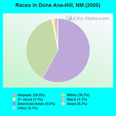
- 14,85158.0%Hispanic
- 9,90538.7%White alone
- 2691.1%Black alone
- 2771.1%Two or more races
- 1500.6%American Indian alone
- 890.3%Asian alone
- 350.1%Other race alone
- 90.04%Native Hawaiian and Other
Pacific Islander alone
Races in Dona Ana-Hill detailed stats: ancestries, foreign born residents, place of birth
 Recent articles from our blog. Our writers, many of them Ph.D. graduates or candidates, create easy-to-read articles on a wide variety of topics.

Current Local Time: MST time zone
Land area: 473.1 square miles.
Population density: 61 people per square mile (very low).
| Dona Ana-Hill CCD: | 0.9% ($748) |
| New Mexico: | 0.7% ($699) |
Nearest city with pop. 50,000+: Las Cruces, NM  (8.7 miles , pop. 74,267).
Nearest city with pop. 200,000+: El Paso, TX (49.4 miles , pop. 563,662).
Nearest city with pop. 1,000,000+: Phoenix, AZ (317.4 miles , pop. 1,321,045).
Nearest cities:
), ), ), )Latitude: 32.45 N, Longitude: 106.76 W
Area code commonly used in this area: 505
| Here: | 4.2% |
| New Mexico: | 3.6% |
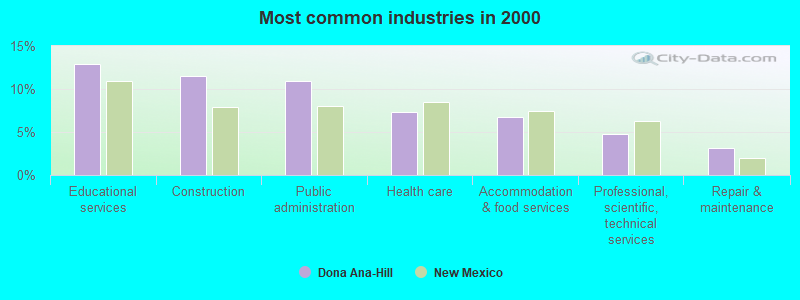
- Educational services (12.9%)
- Construction (11.5%)
- Public administration (11.0%)
- Health care (7.3%)
- Accommodation & food services (6.7%)
- Professional, scientific, technical services (4.8%)
- Repair & maintenance (3.1%)
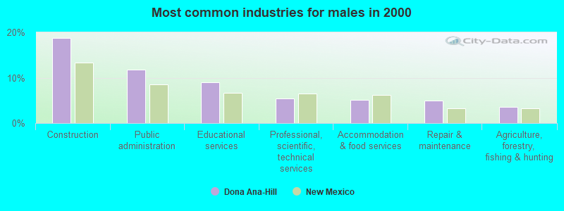
- Construction (18.7%)
- Public administration (11.7%)
- Educational services (9.0%)
- Professional, scientific, technical services (5.5%)
- Accommodation & food services (5.1%)
- Repair & maintenance (4.9%)
- Agriculture, forestry, fishing & hunting (3.6%)
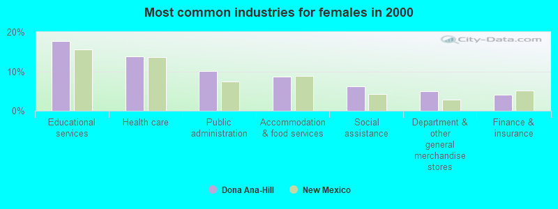
- Educational services (17.7%)
- Health care (13.7%)
- Public administration (10.0%)
- Accommodation & food services (8.7%)
- Social assistance (6.3%)
- Department & other general merchandise stores (4.9%)
- Finance & insurance (4.0%)
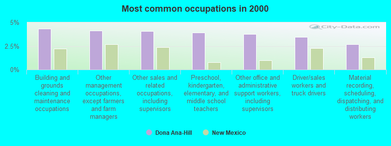
- Building and grounds cleaning and maintenance occupations (4.3%)
- Other management occupations, except farmers and farm managers (4.1%)
- Other sales and related occupations, including supervisors (4.1%)
- Preschool, kindergarten, elementary, and middle school teachers (3.9%)
- Other office and administrative support workers, including supervisors (3.8%)
- Driver/sales workers and truck drivers (3.5%)
- Material recording, scheduling, dispatching, and distributing workers (2.7%)
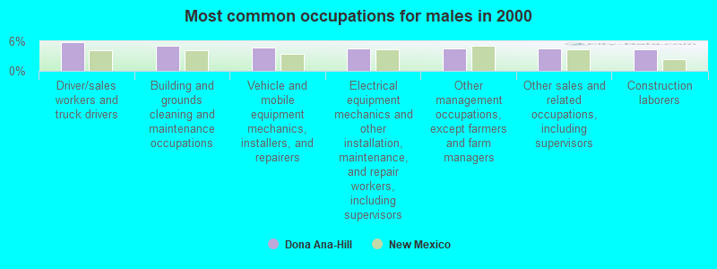
- Driver/sales workers and truck drivers (5.8%)
- Building and grounds cleaning and maintenance occupations (5.1%)
- Vehicle and mobile equipment mechanics, installers, and repairers (4.8%)
- Electrical equipment mechanics and other installation, maintenance, and repair workers, including supervisors (4.5%)
- Other management occupations, except farmers and farm managers (4.5%)
- Other sales and related occupations, including supervisors (4.5%)
- Construction laborers (4.3%)
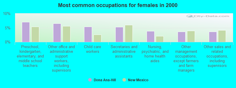
- Preschool, kindergarten, elementary, and middle school teachers (7.0%)
- Other office and administrative support workers, including supervisors (6.5%)
- Child care workers (5.4%)
- Secretaries and administrative assistants (5.2%)
- Nursing, psychiatric, and home health aides (3.8%)
- Other management occupations, except farmers and farm managers (3.6%)
- Other sales and related occupations, including supervisors (3.6%)
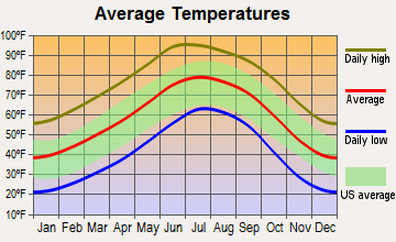
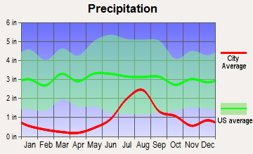
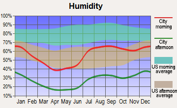
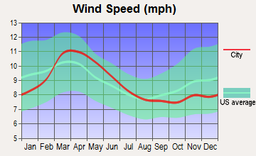
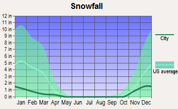
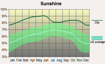
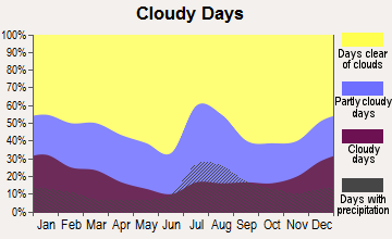
Average climate in Dona Ana-Hill, New Mexico
Based on data reported by over 4,000 weather stations
(lower is better)
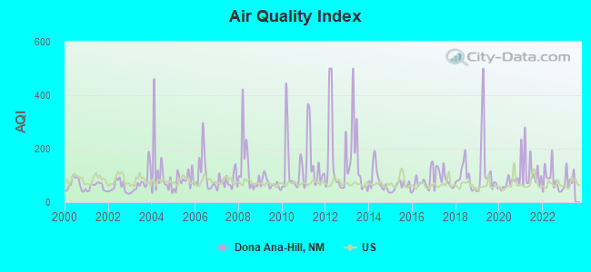
Air Quality Index (AQI) level in 2022 was 81.0. This is about average.
| City: | 81.0 |
| U.S.: | 72.6 |
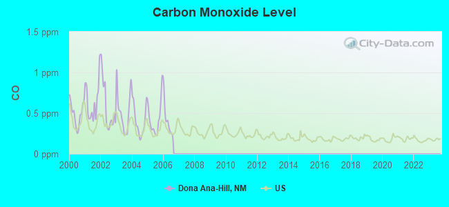
Carbon Monoxide (CO) [ppm] level in 2006 was 0.409. This is significantly worse than average. Closest monitor was 7.4 miles away from the city center.
| City: | 0.409 |
| U.S.: | 0.251 |
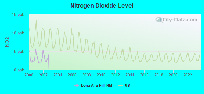
Nitrogen Dioxide (NO2) [ppb] level in 2002 was 3.13. This is significantly better than average. Closest monitor was 5.1 miles away from the city center.
| City: | 3.13 |
| U.S.: | 5.11 |
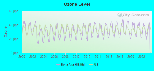
Ozone [ppb] level in 2022 was 31.0. This is about average. Closest monitor was 5.1 miles away from the city center.
| City: | 31.0 |
| U.S.: | 33.3 |
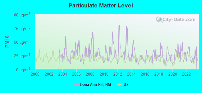
Particulate Matter (PM10) [µg/m3] level in 2022 was 24.1. This is worse than average. Closest monitor was 5.1 miles away from the city center.
| City: | 24.1 |
| U.S.: | 19.2 |
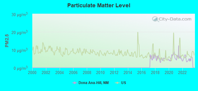
Particulate Matter (PM2.5) [µg/m3] level in 2022 was 4.79. This is significantly better than average. Closest monitor was 8.6 miles away from the city center.
| City: | 4.79 |
| U.S.: | 8.11 |
Earthquake activity:
Dona Ana-Hill-area historical earthquake activity is significantly above New Mexico state average. It is 515% greater than the overall U.S. average.On 6/29/2014 at 04:59:35, a magnitude 5.3 (5.3 MW, Depth: 4.0 mi, Class: Moderate, Intensity: VI - VII) earthquake occurred 140.8 miles away from Dona Ana-Hill center
On 6/28/1992 at 11:57:34, a magnitude 7.6 (6.2 MB, 7.6 MS, 7.3 MW, Depth: 0.7 mi, Class: Major, Intensity: VIII - XII) earthquake occurred 577.3 miles away from Dona Ana-Hill center, causing 3 deaths (1 shaking deaths, 2 other deaths) and 400 injuries, causing $100,000,000 total damage and $40,000,000 insured losses
On 4/14/1995 at 00:32:56, a magnitude 5.7 (5.6 MB, 5.7 MS, 5.7 MW, Depth: 11.1 mi) earthquake occurred 250.2 miles away from Dona Ana-Hill center
On 5/19/1940 at 04:36:40, a magnitude 7.2 (7.2 UK) earthquake occurred 522.1 miles away from the city center, causing $33,000,000 total damage
On 1/4/2006 at 08:32:32, a magnitude 6.6 (6.6 MW, Depth: 8.7 mi, Class: Strong, Intensity: VII - IX) earthquake occurred 435.8 miles away from the city center
On 12/31/1934 at 18:45:56, a magnitude 7.1 (7.1 UK) earthquake occurred 524.8 miles away from the city center
Magnitude types: body-wave magnitude (MB), surface-wave magnitude (MS), moment magnitude (MW)
Natural disasters:
The number of natural disasters in Dona Ana County (8) is smaller than the US average (15).Major Disasters (Presidential) Declared: 5
Emergencies Declared: 2
Causes of natural disasters: Floods: 4, Storms: 3, Fires: 2, Heavy Rain: 1, Hurricane: 1, Mudslide: 1, Other: 1 (Note: some incidents may be assigned to more than one category).
Hospitals and medical centers near Dona Ana-Hill:
- HSA VALLEY VIEW HOSPITAL (Hospital, about 7 miles away; LAS CRUCES, NM)
- MESILLA VALLEY HOSP (Hospital, about 7 miles away; LAS CRUCES, NM)
- CASA DE ORO CARE AND REHABILITATION CENTER (Nursing Home, about 7 miles away; LAS CRUCES, NM)
- MOUNTAIN SHADOWS HEALTH CARE CENTER (Nursing Home, about 7 miles away; LAS CRUCES, NM)
- LAS CRUCES HEALTH CARE CENTER (Nursing Home, about 9 miles away; LAS CRUCES, NM)
- SAGECREST NURSING AND REHABILITATION (Nursing Home, about 9 miles away; LAS CRUCES, NM)
- NEW HOPE HOSPICE INC (Hospital, about 9 miles away; LAS CRUCES, NM)
Colleges/universities with over 2000 students nearest to Dona Ana-Hill:
- New Mexico State University-Main Campus (about 12 miles; Las Cruces, NM; Full-time enrollment: 14,497)
- New Mexico State University-Dona Ana (about 12 miles; Las Cruces, NM; FT enrollment: 5,640)
- The University of Texas at El Paso (about 49 miles; El Paso, TX; FT enrollment: 18,008)
- Vista College (about 50 miles; El Paso, TX; FT enrollment: 3,453)
- El Paso Community College (about 52 miles; El Paso, TX; FT enrollment: 19,576)
- Western New Mexico University (about 92 miles; Silver City, NM; FT enrollment: 2,456)
- Eastern New Mexico University-Roswell Campus (about 144 miles; Roswell, NM; FT enrollment: 2,212)
Points of interest:
Notable locations in Dona Ana-Hill: Wagner Well (A), New Mexico State University Animal Science Ranch (B), Flat Lake Ranch (C), House Pasture Windmill (D), Hille Ranch (E), State University Ranch Headquarters (F), New Mexico State University Animal Science Ranch (G), Cleofas Well (H), Flat Lake Ranch (I), Jornada Experimental Range Headquarters (J), Organ Volunteer Fire Department - East Mesa Volunteer Fire Department (K), Radium Springs Fire Department (L), Organ Volunteer Fire Department (M). Display/hide their locations on the map
Church in Dona Ana-Hill: Our Lady of Purification Catholic Church Historic Site (A). Display/hide its location on the map
Lakes and reservoirs: Isaack Lake (A), Red Lake (B), Hurtt Tank (C), Katell Tank (D), Lawyer Tank (E), Lucero Tank (F), Sump Tank (G), Fleming Tank (H). Display/hide their locations on the map
Streams, rivers, and creeks: Bear Creek (A), Lucero Arroyo (B), Sand Hill Arroyo (C). Display/hide their locations on the map
Parks in Dona Ana-Hill include: Fort Selden State Monument (1), Fort Selden State Monument Historical Marker (2), Bartlett-Garcia Conde Initial Survey Point Historical Marker (3). Display/hide their locations on the map
| This place: | 2.8 people |
| New Mexico: | 2.5 people |
| This place: | 74.4% |
| Whole state: | 65.5% |
| This place: | 9.1% |
| Whole state: | 8.2% |
Likely homosexual households (counted as self-reported same-sex unmarried-partner households)
- Lesbian couples: 0.6% of all households
- Gay men: 0.5% of all households
| This place: | 18.7% |
| Whole state: | 18.4% |
| This place: | 6.1% |
| Whole state: | 7.8% |
People in group quarters in Dona Ana-Hill in 2000:
- 131 people in nursing homes
- 47 people in other noninstitutional group quarters
- 23 people in mental (psychiatric) hospitals or wards
For population 15 years and over in Dona Ana-Hill:
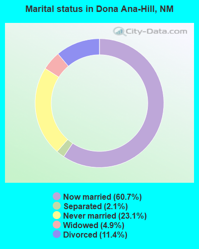
- Never married: 23.1%
- Now married: 60.7%
- Separated: 2.1%
- Widowed: 4.9%
- Divorced: 11.4%
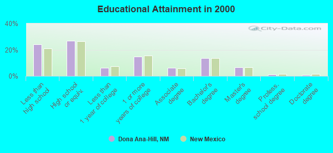
For population 25 years and over in Dona Ana-Hill:
- High school or higher: 75.7%
- Bachelor's degree or higher: 22.2%
- Graduate or professional degree: 8.7%
- Unemployed: 7.1%
- Mean travel time to work (commute): 24.0 minutes
| Here: | 16.2 |
| New Mexico average: | 14.5 |
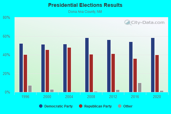
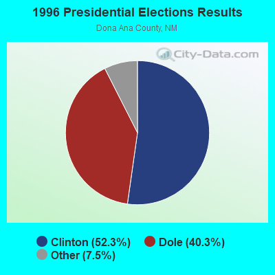
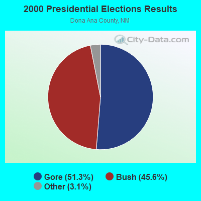

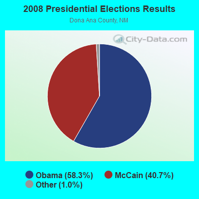
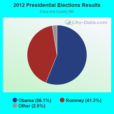
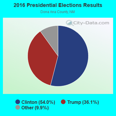
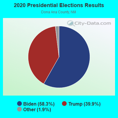
Graphs represent county-level data. Detailed 2008 Election Results
Religion statistics for Dona Ana-Hill, NM (based on Dona Ana County data)
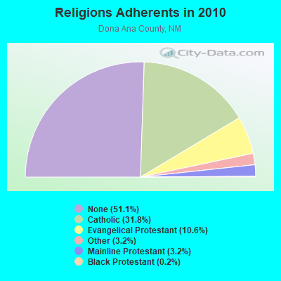
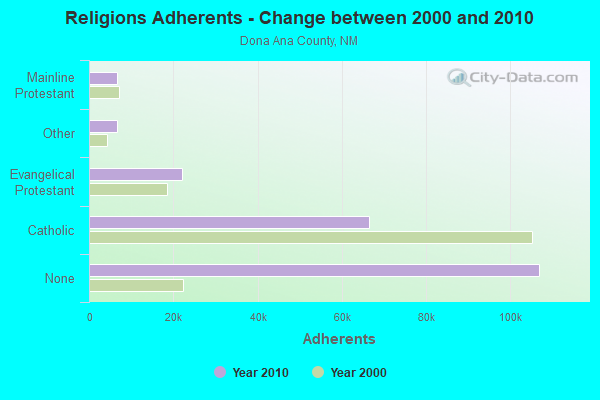
| Religion | Adherents | Congregations |
|---|---|---|
| Catholic | 66,491 | 26 |
| Evangelical Protestant | 22,120 | 114 |
| Other | 6,705 | 25 |
| Mainline Protestant | 6,640 | 17 |
| Black Protestant | 353 | 3 |
| Orthodox | 30 | 1 |
| None | 106,894 | - |
Food Environment Statistics:
| Dona Ana County: | 0.96 / 10,000 pop. |
| New Mexico: | 1.44 / 10,000 pop. |
| Here: | 0.15 / 10,000 pop. |
| New Mexico: | 0.21 / 10,000 pop. |
| This county: | 0.20 / 10,000 pop. |
| New Mexico: | 0.32 / 10,000 pop. |
| This county: | 2.73 / 10,000 pop. |
| New Mexico: | 4.06 / 10,000 pop. |
| Dona Ana County: | 5.35 / 10,000 pop. |
| New Mexico: | 7.12 / 10,000 pop. |
| Dona Ana County: | 5.7% |
| State: | 6.4% |
| Dona Ana County: | 22.7% |
| State: | 22.1% |
| This county: | 15.2% |
| New Mexico: | 11.5% |
6.15% of this county's 2021 resident taxpayers lived in other counties in 2020 ($52,361 average adjusted gross income)
| Here: | 6.15% |
| New Mexico average: | 6.50% |
0.06% of residents moved from foreign countries ($655 average AGI)
Dona Ana County: 0.06% New Mexico average: 0.07%
Top counties from which taxpayers relocated into this county between 2020 and 2021:
| from El Paso County, TX | |
| from Bernalillo County, NM | |
| from Otero County, NM |
5.98% of this county's 2020 resident taxpayers moved to other counties in 2021 ($48,402 average adjusted gross income)
| Here: | 5.98% |
| New Mexico average: | 6.53% |
0.03% of residents moved to foreign countries ($376 average AGI)
Dona Ana County: 0.03% New Mexico average: 0.05%
Top counties to which taxpayers relocated from this county between 2020 and 2021:
| to El Paso County, TX | |
| to Bernalillo County, NM | |
| to Otero County, NM |
Strongest AM radio stations in Dona Ana-Hill:
- KSNM (570 AM; 5 kW; LAS CRUCES, NM; Owner: SUNRISE BROADCASTING INC.)
- KELP (1590 AM; 50 kW; EL PASO, TX; Owner: MCCLATCHEY BROADCASTING)
- KTSM (690 AM; 10 kW; EL PASO, TX; Owner: CCB TEXAS LICENSES, L.P.)
- KOBE (1450 AM; 1 kW; LAS CRUCES, NM; Owner: EDWARDS MEDIA LTD. CO.)
- KXPL (1060 AM; daytime; 10 kW; EL PASO, TX; Owner: K-FINA RESULTS, INC.)
- KAMA (750 AM; 10 kW; EL PASO, TX; Owner: TICHENOR LICENSE CORPORATION ("TLC"))
- KROD (600 AM; 5 kW; EL PASO, TX; Owner: REGENT LICENSEE OF EL PASO, INC.)
- KBNA (920 AM; 10 kW; EL PASO, TX; Owner: TICHENOR LICENSE CORPORATION ("TLC"))
- KSVE (1150 AM; 10 kW; EL PASO, TX; Owner: ENTRAVISION HOLDINGS, LLC)
- KINF (1020 AM; 50 kW; ROSWELL, NM; Owner: JAMES CRYSTAL HOLDINGS OF NEW MEXICO, INC.)
- KHEY (1380 AM; 5 kW; EL PASO, TX; Owner: CCB TEXAS LICENSES, L.P.)
- KKOB (770 AM; 50 kW; ALBUQUERQUE, NM; Owner: CITADEL BROADCASTING COMPANY)
- KTNN (660 AM; 50 kW; WINDOW ROCK, AZ; Owner: THE NAVAJO NATION)
Strongest FM radio stations in Dona Ana-Hill:
- K211EN (90.1 FM; LAS CRUCES, NM; Owner: CALVARY CHAPEL OF TWIN FALLS, INC.)
- K220GF (91.9 FM; LAS CRUCES, NM; Owner: PENSACOLA CHRISTIAN COLLEGE, INC.)
- KROL (99.5 FM; LAS CRUCES, NM; Owner: RIO GRANDE CHRISTIAN BROADCASTING CO)
- KHQT (103.1 FM; LAS CRUCES, NM; Owner: RICHARDSON COMMERCIAL CORPORATION)
- K216CK (91.1 FM; TRUTH OR CONSEQUENCE, NM; Owner: CONNECTION COMMUNICATIONS ASSOC., INC.)
- KKVS (98.7 FM; TRUTH OR CONSEQUENCE, NM; Owner: RICHARDSON COMMERCIAL CORPORATION)
- KVLC (101.1 FM; HATCH, NM; Owner: RADIO PROPERTY DEVELOPMENT, INC.)
- KOFX (92.3 FM; EL PASO, TX; Owner: ENTRAVISION HOLDINGS, LLC)
- KTSM-FM (99.9 FM; EL PASO, TX; Owner: CCB TEXAS LICENSES, L.P.)
- K219BX (91.7 FM; EL PASO, ETC., TX; Owner: FAMILY STATIONS, INC.)
- K205DE (88.9 FM; ALAMOGORDO, NM; Owner: PAULINO BERNAL EVANGELISM)
- K256AI (99.1 FM; ALAMOGORDO, NM; Owner: CALVARY CHAPEL OF TWIN FALLS, INC.)
- KSII (93.1 FM; EL PASO, TX; Owner: REGENT LICENSEE OF EL PASO, INC.)
- KINT-FM (93.9 FM; EL PASO, TX; Owner: ENTRAVISION HOLDINGS, LLC)
- KHEY-FM (96.3 FM; EL PASO, TX; Owner: CCB TEXAS LICENSES, L.P.)
- KLAQ (95.5 FM; EL PASO, TX; Owner: REGENT LICENSEE OF EL PASO, INC.)
- KZZX (105.3 FM; ALAMOGORDO, NM; Owner: BURT BROADCASTING, INC.)
- K215EC (91.1 FM; ALAMOGORDO, NM; Owner: CALVARY CHAPEL OF TWIN FALLS, INC.)
- KRWG (90.7 FM; LAS CRUCES, NM; Owner: REGENTS OF NEW MEXICO STATE UNIVERSITY)
- KGRT-FM (103.9 FM; LAS CRUCES, NM; Owner: SUNRISE BROADCASTING INC.)
TV broadcast stations around Dona Ana-Hill:
- K54GR (Channel 54; LAS CRUCES, NM; Owner: REGENTS OF NEW MEXICO STATE UNIV.)
- K46DH (Channel 46; LAS CRUCES, NM; Owner: COUNCIL TREE COMMUNICATIONS VI, L.P.)
- KLCP-LP (Channel 30; LAS CRUCES, NM; Owner: PRIME TIME CHRISTIAN B/CING., INC.)
- KRWG-TV (Channel 22; LAS CRUCES, NM; Owner: REGENTS OF NEW MEXICO STATE UNIVERSITY)
- K42DJ (Channel 42; LAS CRUCES, NM; Owner: KOB-TV, LLC)
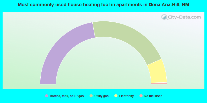
- 53.1%Utility gas
- 34.1%Bottled, tank, or LP gas
- 9.3%Electricity
- 2.8%Wood
- 0.3%Other fuel
- 0.3%Solar energy
- 0.1%Fuel oil, kerosene, etc.
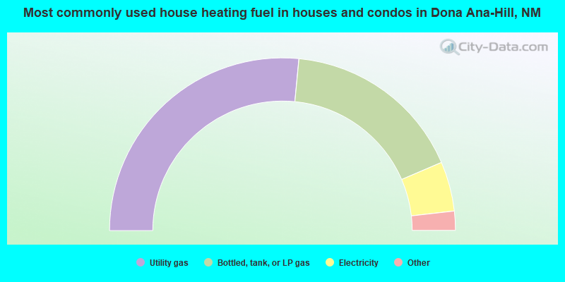
- 44.4%Bottled, tank, or LP gas
- 42.5%Utility gas
- 12.2%Electricity
- 0.9%No fuel used
Dona Ana-Hill compared to New Mexico state average:
- Unemployed percentage below state average.
- Median age below state average.
- Foreign-born population percentage significantly below state average.
- Length of stay since moving in significantly above state average.
- Number of rooms per house significantly below state average.
- House age significantly below state average.
Dona Ana-Hill on our top lists:
- #17 on the list of "Top 101 cities with largest percentage of females in occupations: child care workers (population 5,000+)"
- #25 on the list of "Top 101 cities with largest percentage of females in occupations: communications equipment operators (population 5,000+)"
- #27 on the list of "Top 101 cities with largest percentage of males in occupations: communications equipment operators (population 5,000+)"
- #41 on the list of "Top 101 cities with largest percentage of males in occupations: construction laborers (population 5,000+)"
- #42 on the list of "Top 101 cities with largest percentage of males in occupations: pipelayers, plumbers, pipefitters, and steamfitters (population 5,000+)"
- #45 on the list of "Top 101 cities with largest percentage of males in occupations: drafters, engineering, and mapping technicians (population 5,000+)"
- #77 on the list of "Top 101 cities with the largest percentage of mobile homes (2,000+ housing units)"
- #79 on the list of "Top 101 cities with largest percentage of females in industries: social assistance (population 5,000+)"
- #96 on the list of "Top 101 cities with largest percentage of females in industries: department and other general merchandise stores (population 5,000+)"
- #96 on the list of "Top 101 cities with largest percentage of males in industries: repair and maintenance (population 5,000+)"
- #2 on the list of "Top 101 counties with the highest Particulate Matter (PM10) Annual air pollution readings in 2012 (µg/m3)"
- #7 on the list of "Top 101 counties with the highest Particulate Matter (PM2.5) Annual air pollution readings in 2012 (µg/m3)"
- #33 on the list of "Top 101 counties with highest percentage of residents voting for 3rd party candidates in the 2012 Presidential Election (pop. 50,000+)"
- #34 on the list of "Top 101 counties with the worst general health status score of residents (1-5), 3 years of data"
- #53 on the list of "Top 101 counties with the lowest percentage of residents that drank alcohol in the past 30 days"