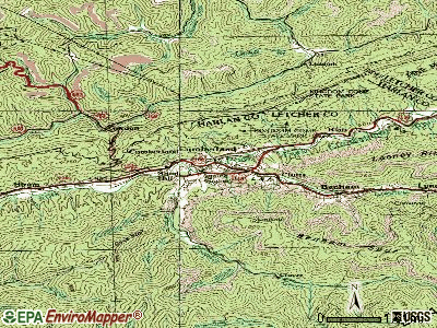
Cumberland City, Kentucky
Submit your own pictures of this place and show them to the world
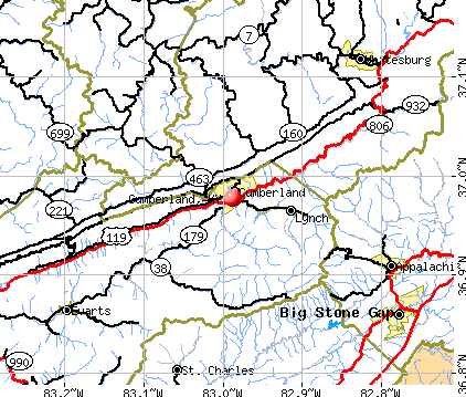
- OSM Map
- General Map
- Google Map
- MSN Map
| Males: 1,335 | |
| Females: 1,316 |
| Median resident age: | 38.9 years |
| Kentucky median age: | 35.9 years |
Zip code: 42602
| Cumberland City: | $49,431 |
| KY: | $59,341 |
Estimated per capita income in 2022: $21,683 (it was $11,886 in 2000)
Cumberland City CCD income, earnings, and wages data
Estimated median house or condo value in 2022: $88,574 (it was $37,200 in 2000)
| Cumberland City: | $88,574 |
| KY: | $196,300 |
Mean prices in 2022: all housing units: $112,810; detached houses: $127,555; mobile homes: $56,532
Cumberland City, KY residents, houses, and apartments details
Detailed information about poverty and poor residents in Cumberland City, KY


- 2,65798.6%White alone
- 190.7%Hispanic
- 130.5%American Indian alone
- 50.2%Two or more races
- 10.04%Asian alone

Races in Cumberland City detailed stats: ancestries, foreign born residents, place of birth
 Recent articles from our blog. Our writers, many of them Ph.D. graduates or candidates, create easy-to-read articles on a wide variety of topics.
Current Local Time: CST time zone
Elevation: 1053 feet
Land area: 78.2 square miles.
Population density: 34 people per square mile (very low).
| Cumberland City CCD: | 0.8% ($284) |
| Kentucky: | 0.8% ($610) |
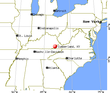
Nearest city with pop. 50,000+: Knoxville, TN  (85.8 miles , pop. 173,890).
Nearest city with pop. 200,000+: Fayette, KY (91.9 miles , pop. 260,512).
Nearest city with pop. 1,000,000+: Chicago, IL (375.5 miles , pop. 2,896,016).
Nearest cities:
), ), ), ), Latitude: 36.79 N, Longitude: 85.10 W

| Here: | 4.7% |
| Kentucky: | 3.8% |

- Health care (9.2%)
- Apparel (8.7%)
- Educational services (7.6%)
- Agriculture, forestry, fishing & hunting (7.2%)
- Construction (7.1%)
- Accommodation & food services (6.9%)
- Food & beverage stores (6.2%)

- Agriculture, forestry, fishing & hunting (12.6%)
- Construction (12.4%)
- Wood products (9.4%)
- Educational services (6.8%)
- Food & beverage stores (4.5%)
- Food (4.2%)
- Professional, scientific, technical services (3.6%)

- Health care (19.7%)
- Apparel (17.1%)
- Accommodation & food services (12.3%)
- Educational services (8.7%)
- Food & beverage stores (8.5%)
- Food (4.4%)
- Social assistance (3.6%)

- Other production occupations, including supervisors (8.3%)
- Textile, apparel, and furnishings workers (7.5%)
- Building and grounds cleaning and maintenance occupations (6.1%)
- Electrical equipment mechanics and other installation, maintenance, and repair workers, including supervisors (5.2%)
- Farmers and farm managers (4.4%)
- Other sales and related occupations, including supervisors (4.2%)
- Waiters and waitresses (3.4%)

- Electrical equipment mechanics and other installation, maintenance, and repair workers, including supervisors (9.1%)
- Other production occupations, including supervisors (8.0%)
- Farmers and farm managers (7.7%)
- Building and grounds cleaning and maintenance occupations (6.4%)
- Agricultural workers, including supervisors (5.0%)
- Other sales and related occupations, including supervisors (4.4%)
- Construction traders workers except carpenters, electricians, painters, plumbers, and construction laborers (4.2%)

- Textile, apparel, and furnishings workers (12.9%)
- Other production occupations, including supervisors (8.7%)
- Waiters and waitresses (7.8%)
- Cashiers (7.8%)
- Secretaries and administrative assistants (7.8%)
- Registered nurses (6.0%)
- Building and grounds cleaning and maintenance occupations (5.6%)
Average climate in Cumberland City, Kentucky
Based on data reported by over 4,000 weather stations


|
|

Tornado activity:
Cumberland City-area historical tornado activity is near Kentucky state average. It is 31% greater than the overall U.S. average.
On 4/3/1974, a category F4 (max. wind speeds 207-260 mph) tornado 16.5 miles away from the Cumberland City place center killed 5 people and injured 6 people and caused between $500,000 and $5,000,000 in damages.
On 4/3/1974, a category F4 tornado 17.9 miles away from the place center killed 10 people and injured 113 people and caused between $5000 and $50,000 in damages.
Earthquake activity:
Cumberland City-area historical earthquake activity is significantly above Kentucky state average. It is 114% greater than the overall U.S. average.On 7/27/1980 at 18:52:21, a magnitude 5.2 (5.1 MB, 4.7 MS, 5.0 UK, 5.2 UK, Class: Moderate, Intensity: VI - VII) earthquake occurred 116.6 miles away from Cumberland City center
On 4/18/2008 at 09:36:59, a magnitude 5.4 (5.1 MB, 4.8 MS, 5.4 MW, 5.2 MW) earthquake occurred 191.1 miles away from Cumberland City center
On 4/18/2008 at 09:36:59, a magnitude 5.2 (5.2 MW, Depth: 8.9 mi) earthquake occurred 191.0 miles away from the city center
On 11/30/1973 at 07:48:41, a magnitude 4.7 (4.7 MB, 4.6 ML, Class: Light, Intensity: IV - V) earthquake occurred 93.4 miles away from Cumberland City center
On 6/18/2002 at 17:37:15, a magnitude 5.0 (4.3 MB, 4.6 MW, 5.0 LG) earthquake occurred 168.9 miles away from the city center
On 4/29/2003 at 08:59:39, a magnitude 4.9 (4.4 MB, 4.6 MW, 4.9 LG) earthquake occurred 161.6 miles away from the city center
Magnitude types: regional Lg-wave magnitude (LG), body-wave magnitude (MB), local magnitude (ML), surface-wave magnitude (MS), moment magnitude (MW)
Natural disasters:
The number of natural disasters in Clinton County (9) is smaller than the US average (15).Major Disasters (Presidential) Declared: 6
Emergencies Declared: 2
Causes of natural disasters: Storms: 3, Floods: 2, Tornadoes: 2, Winter Storms: 2, Blizzard: 1, Freeze: 1, Hurricane: 1, Mudslide: 1, Snow: 1, Snowfall: 1, Other: 1 (Note: some incidents may be assigned to more than one category).
Hospitals and medical centers near Cumberland City:
- CLINTON COUNTY HOSPITAL, INC Acute Care Hospitals (about 7 miles away; ALBANY, KY)
- CLINTON COUNTY CARE AND REHABILITATION CENTER (Nursing Home, about 7 miles away; ALBANY, KY)
- WAYNE COUNTY HOSPITAL Critical Access Hospitals (about 13 miles away; MONTICELLO, KY)
- CUMBERLAND COUNTY HOSPITAL Critical Access Hospitals (about 15 miles away; BURKESVILLE, KY)
- CUMBERLAND VALLEY MANOR (Nursing Home, about 16 miles away; BURKESVILLE, KY)
- PICKETT CARE AND REHABILITATION CENTER (Nursing Home, about 16 miles away; BYRDSTOWN, TN)
- PICKETT COUNTY NURSING HOME (Nursing Home, about 16 miles away; BYRDSTOWN, TN)
Colleges/universities with over 2000 students nearest to Cumberland City:
- Lindsey Wilson College (about 25 miles; Columbia, KY; Full-time enrollment: 2,552)
- Somerset Community College (about 33 miles; Somerset, KY; FT enrollment: 4,698)
- Campbellsville University (about 41 miles; Campbellsville, KY; FT enrollment: 2,948)
- Tennessee Technological University (about 49 miles; Cookeville, TN; FT enrollment: 9,761)
- University of the Cumberlands (about 53 miles; Williamsburg, KY; FT enrollment: 3,585)
- Roane State Community College (about 69 miles; Harriman, TN; FT enrollment: 4,302)
- Elizabethtown Community and Technical College (about 76 miles; Elizabethtown, KY; FT enrollment: 3,762)
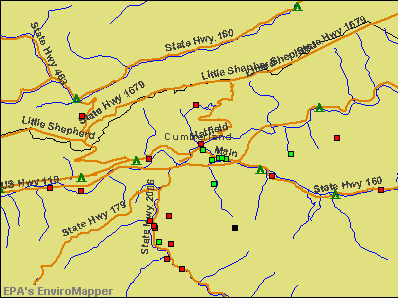
Points of interest:
Notable locations in Cumberland City: Grahams Crossroads (A), Piney Woods (B), Grider Hill Dock (C), Seminary (D). Display/hide their locations on the map
Churches in Cumberland City include: Walnut Grove Church (A), Lands Chapel (B), Mount Union Church (C), Aaron Chapel (D), Cave Spring Church (E), Davis Chapel (F), Fairview Church (G). Display/hide their locations on the map
Cemeteries: Cartwright Cemetery (1), Walnut Grove Church Cemetery (2), Brumley Cemetery (3), Piercy Cemetery (4), Hopkins Cemetery (5), Ray Cemetery (6), Hickory Ridge Cemetery (7). Display/hide their locations on the map
Streams, rivers, and creeks: Dicken Branch (A), Brown Creek (B), Turkeypen Creek (C), Tearcoat Creek (D), Williams Creek (E), Sugarcamp Branch (F), Laurel Creek (G), York Branch (H), Owens Branch (I). Display/hide their locations on the map
| This place: | 2.4 people |
| Kentucky: | 2.5 people |
| This place: | 70.7% |
| Whole state: | 66.9% |
| This place: | 3.6% |
| Whole state: | 6.4% |
Likely homosexual households (counted as self-reported same-sex unmarried-partner households)
- Lesbian couples: 0.3% of all households
- Gay men: 0.1% of all households
| This place: | 18.4% |
| Whole state: | 15.8% |
| This place: | 6.9% |
| Whole state: | 6.6% |
For population 15 years and over in Cumberland City:

- Never married: 15.1%
- Now married: 68.7%
- Separated: 1.6%
- Widowed: 4.9%
- Divorced: 11.3%
For population 25 years and over in Cumberland City:
- High school or higher: 57.8%
- Bachelor's degree or higher: 9.2%
- Graduate or professional degree: 3.5%
- Unemployed: 4.5%
- Mean travel time to work (commute): 21.5 minutes


| Here: | 17.7 |
| Kentucky average: | 13.8 |
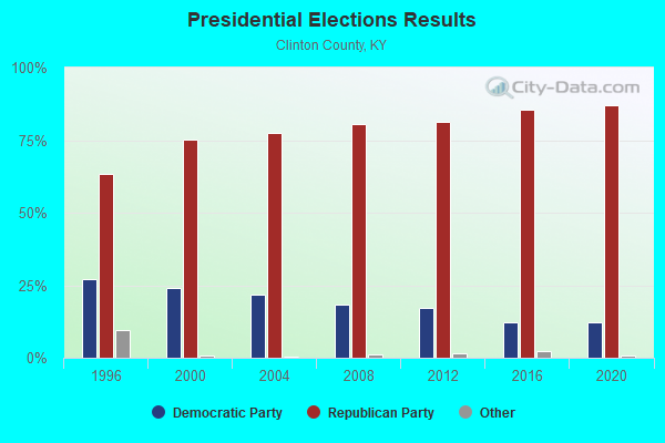
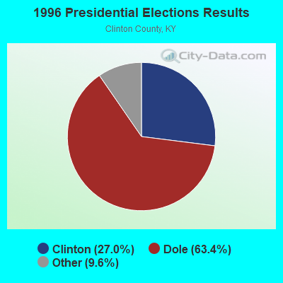
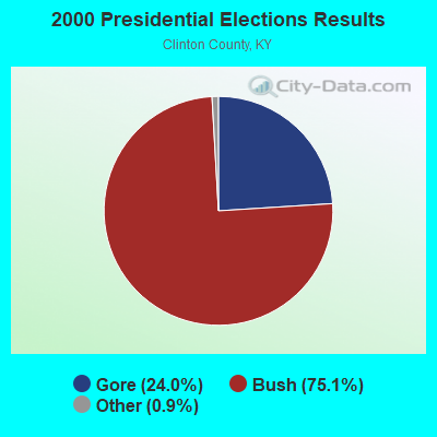
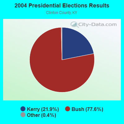
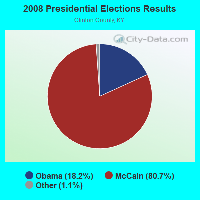
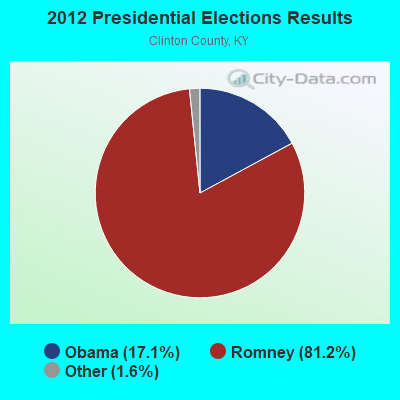

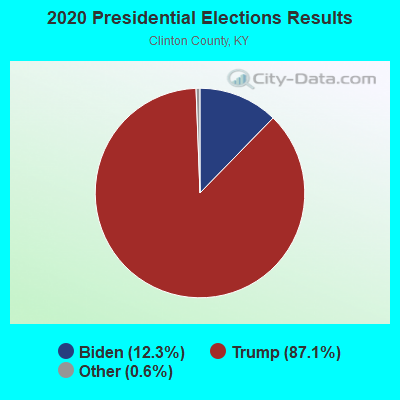
Graphs represent county-level data. Detailed 2008 Election Results
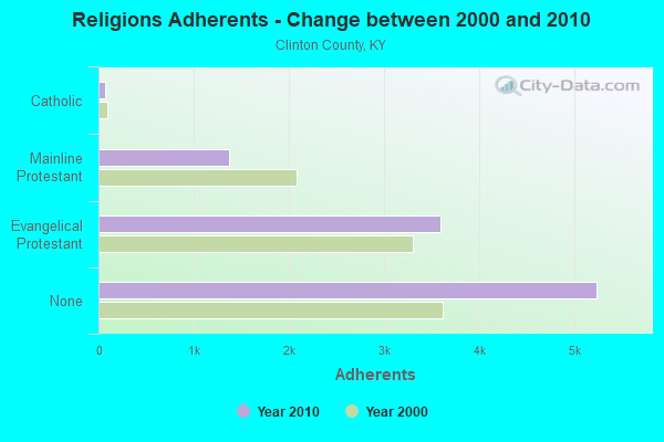
Religion statistics for Cumberland City, KY (based on Clinton County data)
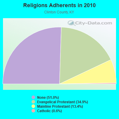
| Religion | Adherents | Congregations |
|---|---|---|
| Evangelical Protestant | 3,590 | 17 |
| Mainline Protestant | 1,377 | 11 |
| Catholic | 65 | 1 |
| None | 5,240 | - |
Food Environment Statistics:
| Here: | 2.10 / 10,000 pop. |
| Kentucky: | 2.19 / 10,000 pop. |
| Clinton County: | 9.43 / 10,000 pop. |
| Kentucky: | 4.36 / 10,000 pop. |
| This county: | 5.24 / 10,000 pop. |
| State: | 5.74 / 10,000 pop. |
| Clinton County: | 11.9% |
| Kentucky: | 11.0% |
| This county: | 30.9% |
| Kentucky: | 30.0% |
| This county: | 20.8% |
| State: | 15.9% |
Strongest AM radio stations in Cumberland City:
- WANY (1390 AM; daytime; 1 kW; ALBANY, KY; Owner: PAMELA ALLRED DBA ALBANY BROADCASTING COMPANY)
- WKVL (850 AM; daytime; 50 kW; KNOXVILLE, TN; Owner: HORNE RADIO, LLC)
- WSM (650 AM; 50 kW; NASHVILLE, TN; Owner: GAYLORD ENTERTAINMENT COMPANY)
- WHAS (840 AM; 50 kW; LOUISVILLE, KY; Owner: CLEAR CHANNEL BROADCASTING LICENSES, INC.)
- WAMB (1160 AM; 50 kW; DONELSON, TN; Owner: GREAT SOUTHERN BROADCASTING COMPANY, INC.)
- WFLW (1360 AM; 1 kW; MONTICELLO, KY; Owner: STEPHEN W. STAPLES, JR.)
- WWAM (820 AM; daytime; 50 kW; JASPER, TN; Owner: SHELTON BROADCASTING SYSTEM)
- WKDA (1200 AM; 50 kW; NASHVILLE, TN; Owner: RADIO NASHVILLE, INC.)
- WJKY (1060 AM; daytime; 1 kW; JAMESTOWN, KY; Owner: LAKE CUMBERLAND BROADCASTERS)
- WLAC (1510 AM; 50 kW; NASHVILLE, TN; Owner: CAPSTAR TX LIMITED PARTNERSHIP)
- WNQM (1300 AM; 50 kW; NASHVILLE, TN; Owner: WNQM. INC.)
- WFLI (1070 AM; 50 kW; LOOKOUT MOUNTAIN, TN; Owner: WFLI, INC.)
- WEKC (710 AM; daytime; 4 kW; WILLIAMSBURG, KY; Owner: GERALD PARKS)
Strongest FM radio stations in Cumberland City:
- WMKZ (93.1 FM; MONTICELLO, KY; Owner: MONTICELLO-WAYNE COUNTY MEDIA, INC.)
- WKYM (101.7 FM; MONTICELLO, KY; Owner: STEPHEN W. STAPLES JR.)
- WJRS (104.9 FM; JAMESTOWN, KY; Owner: LAKE CUMBERLAND BROADCASTERS)
- WKYR-FM (107.9 FM; BURKESVILLE, KY; Owner: RAY MULLINIX)
- WGSQ (94.7 FM; COOKEVILLE, TN; Owner: CLEAR CHANNEL BROADCASTING LICENSES, INC.)
- WLQK (95.9 FM; LIVINGSTON, TN; Owner: JWC BROADCASTING)
- WHVE (92.7 FM; RUSSELL SPRINGS, KY; Owner: SHORELINE COMMUNICATIONS, INC)
- WDCL-FM (89.7 FM; SOMERSET, KY; Owner: WESTERN KENTUCKY UNIVERSITY)
- WSEK (97.1 FM; SOMERSET, KY; Owner: CAPSTAR TX LIMITED PARTNERSHIP)
- WDEB-FM (103.9 FM; JAMESTOWN, TN; Owner: BAZ BROADCASTING, INC.)
- WKWY (102.7 FM; TOMPKINSVILLE, KY; Owner: J.K. WHITTIMORE)
- WANY-FM (106.3 FM; ALBANY, KY; Owner: PAMELA ALLRED DBA ALBANY BROADCASTING COMPANY)
TV broadcast stations around Cumberland City:
- WKSO-TV (Channel 29; SOMERSET, KY; Owner: KENTUCKY AUTHORITY FOR EDUCATIONAL TV)

- 49.0%Electricity
- 28.4%Bottled, tank, or LP gas
- 13.6%Fuel oil, kerosene, etc.
- 5.8%Wood
- 1.9%Coal or coke
- 1.4%Utility gas

- 31.9%Electricity
- 24.7%Bottled, tank, or LP gas
- 19.9%Wood
- 12.0%Fuel oil, kerosene, etc.
- 4.2%Utility gas
- 3.6%Coal or coke
- 3.6%No fuel used
Cumberland City compared to Kentucky state average:
- Median house value below state average.
- Unemployed percentage significantly below state average.
- Black race population percentage significantly below state average.
- Hispanic race population percentage significantly below state average.
- Foreign-born population percentage significantly below state average.
- Renting percentage below state average.
- Length of stay since moving in significantly above state average.
- Number of rooms per house significantly below state average.
- House age significantly below state average.
- Number of college students below state average.
- Percentage of population with a bachelor's degree or higher below state average.