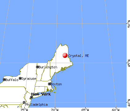
Crystal, Maine
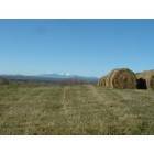
Crystal: Fall Mt Katahdin Crystal Maine
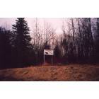
Crystal: From Patten entering Crystal.
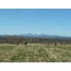
Crystal: Fall Mt Katahdin Crystal Maine

Crystal: Stream Crystal Maine
- add
your
Submit your own pictures of this town and show them to the world
- OSM Map
- General Map
- Google Map
- MSN Map
Population change since 2000: -5.6%
 |
| Males: 134 | |
| Females: 135 |
| Median resident age: | 51.8 years |
| Maine median age: | 43.0 years |
Zip codes: 04747.
| Crystal: | $50,744 |
| ME: | $69,543 |
Estimated per capita income in 2022: $29,591 (it was $14,338 in 2000)
Crystal town income, earnings, and wages data
Estimated median house or condo value in 2022: $117,430 (it was $48,500 in 2000)
| Crystal: | $117,430 |
| ME: | $290,600 |
Mean prices in 2022: all housing units: $179,108; detached houses: $185,023; townhouses or other attached units: $218,327; in 2-unit structures: $262,505; in 3-to-4-unit structures: $121,406; in 5-or-more-unit structures: $185,084; mobile homes: $117,009; occupied boats, rvs, vans, etc.: $12,682
Detailed information about poverty and poor residents in Crystal, ME


- 26698.9%White alone
- 10.4%American Indian alone
- 10.4%Two or more races
- 10.4%Hispanic

Races in Crystal detailed stats: ancestries, foreign born residents, place of birth
According to our research of Maine and other state lists, there was 1 registered sex offender living in Crystal, Maine as of May 23, 2024.
The ratio of all residents to sex offenders in Crystal is 269 to 1.
 Recent articles from our blog. Our writers, many of them Ph.D. graduates or candidates, create easy-to-read articles on a wide variety of topics.

 | crystal me (9 replies) |
| Maine Demographics (36 replies) |
| Maine and IPAs --- Or, is there life beyond Pale Ale? (11 replies) |
| New House construction and building on acreage (16 replies) |
| Lead Ban Lifted (14 replies) |
| Brunswick as a place to retire? (8 replies) |
Latest news from Crystal, ME collected exclusively by city-data.com from local newspapers, TV, and radio stations
Ancestries: English (39.6%), Irish (19.3%), French (17.2%), Scotch-Irish (5.3%), United States (5.3%), French Canadian (4.2%).
Current Local Time: EST time zone
Incorporated on 03/21/1901
Elevation: 511 feet
Land area: 40.1 square miles.
Population density: 6.7 people per square mile (very low).
2 residents are foreign born
| This town: | 0.7% |
| Maine: | 2.9% |
| Crystal town: | 1.0% ($468) |
| Maine: | 1.5% ($1,417) |
Nearest city with pop. 50,000+: Portland, ME  (186.1 miles , pop. 64,249).
Nearest city with pop. 200,000+: Boston, MA (287.6 miles , pop. 589,141).
Nearest city with pop. 1,000,000+: Bronx, NY (450.6 miles , pop. 1,332,650).
Nearest cities:
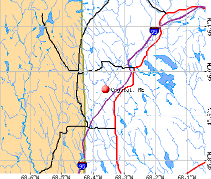
), Latitude: 45.99 N, Longitude: 68.36 W
Area code commonly used in this area: 207


| Here: | 5.3% |
| Maine: | 3.4% |


- Health care (15.1%)
- Social assistance (10.3%)
- Construction (9.5%)
- Public administration (9.5%)
- Accommodation & food services (7.9%)
- Educational services (7.1%)
- Agriculture, forestry, fishing & hunting (6.3%)

- Construction (20.3%)
- Public administration (15.3%)
- Wood products (10.2%)
- Social assistance (8.5%)
- Agriculture, forestry, fishing & hunting (6.8%)
- Accommodation & food services (6.8%)
- Food (5.1%)

- Health care (28.4%)
- Social assistance (11.9%)
- Educational services (10.4%)
- Accommodation & food services (9.0%)
- Other direct selling establishments (7.5%)
- Finance & insurance (7.5%)
- Agriculture, forestry, fishing & hunting (6.0%)

- Nursing, psychiatric, and home health aides (15.1%)
- Other sales and related occupations, including supervisors (5.6%)
- Other office and administrative support workers, including supervisors (5.6%)
- Other management occupations, except farmers and farm managers (4.8%)
- Laborers and material movers, hand (4.0%)
- Woodworkers (4.0%)
- Carpenters (4.0%)

- Carpenters (8.5%)
- Woodworkers (8.5%)
- Laborers and material movers, hand (8.5%)
- Engineers (6.8%)
- Other management occupations, except farmers and farm managers (6.8%)
- Supervisors, construction and extraction workers (6.8%)
- Vehicle and mobile equipment mechanics, installers, and repairers (6.8%)

- Nursing, psychiatric, and home health aides (25.4%)
- Other sales and related occupations, including supervisors (10.4%)
- Other office and administrative support workers, including supervisors (7.5%)
- Life, physical, and social science technicians (6.0%)
- Other teachers, instructors, education, training, and library occupations (6.0%)
- Financial clerks, except bookkeeping, accounting and auditing clerks (6.0%)
- Other protective service workers, including supervisors (4.5%)
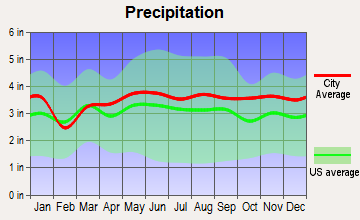
Average climate in Crystal, Maine
Based on data reported by over 4,000 weather stations


Earthquake activity:
Crystal-area historical earthquake activity is significantly above Maine state average. It is 84% smaller than the overall U.S. average.On 4/20/2002 at 10:50:47, a magnitude 5.3 (5.3 ML, Depth: 3.0 mi, Class: Moderate, Intensity: VI - VII) earthquake occurred 279.3 miles away from Crystal center
On 4/20/2002 at 10:50:47, a magnitude 5.2 (5.2 MB, 4.2 MS, 5.2 MW, 5.0 MW) earthquake occurred 280.9 miles away from the city center
On 10/16/2012 at 23:12:25, a magnitude 4.7 (4.7 ML, Depth: 10.0 mi, Class: Light, Intensity: IV - V) earthquake occurred 200.2 miles away from Crystal center
On 10/7/1983 at 10:18:46, a magnitude 5.3 (5.1 MB, 5.3 LG, 5.1 ML) earthquake occurred 324.8 miles away from Crystal center
On 7/14/2006 at 09:34:48, a magnitude 3.9 (3.9 MD, Depth: 8.6 mi, Class: Light, Intensity: II - III) earthquake occurred 63.3 miles away from Crystal center
On 1/19/1982 at 00:14:42, a magnitude 4.7 (4.5 MB, 4.7 MD, 4.5 LG) earthquake occurred 234.5 miles away from the city center
Magnitude types: regional Lg-wave magnitude (LG), body-wave magnitude (MB), duration magnitude (MD), local magnitude (ML), surface-wave magnitude (MS), moment magnitude (MW)
Natural disasters:
The number of natural disasters in Aroostook County (22) is greater than the US average (15).Major Disasters (Presidential) Declared: 13
Emergencies Declared: 9
Causes of natural disasters: Floods: 10, Storms: 8, Snows: 7, Heavy Rains: 2, Blizzard: 1, Hurricane: 1, Ice Storm: 1, Snowfall: 1, Snowstorm: 1, Wind: 1, Winter Storm: 1, Other: 2 (Note: some incidents may be assigned to more than one category).
Colleges/universities with over 2000 students nearest to Crystal:
- University of Maine (about 78 miles; Orono, ME; Full-time enrollment: 8,931)
- Husson University (about 83 miles; Bangor, ME; FT enrollment: 2,421)
- University of Maine at Farmington (about 127 miles; Farmington, ME; FT enrollment: 2,036)
- University of Maine at Augusta (about 135 miles; Augusta, ME; FT enrollment: 3,204)
- Saint Joseph's College of Maine (about 183 miles; Standish, ME; FT enrollment: 2,010)
- Southern Maine Community College (about 187 miles; South Portland, ME; FT enrollment: 4,666)
- University of Southern Maine (about 187 miles; Portland, ME; FT enrollment: 6,647)
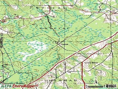
Points of interest:
Churches in Crystal include: Belvedere Church (A), Patten United Methodist Church (B). Display/hide their locations on the map
Cemetery: Crystal Cemetery (1). Display/hide its location on the map
Lakes and swamps: Lost Pond (A), Thousand Acre Bog (B). Display/hide their locations on the map
Streams, rivers, and creeks: Webster Brook (A), Crystal Brook (B), Lyman Brook (C), Cold Brook (D), Bog Brook (E). Display/hide their locations on the map
| This town: | 2.3 people |
| Maine: | 2.3 people |
| This town: | 73.0% |
| Whole state: | 62.9% |
| This town: | 4.3% |
| Whole state: | 9.4% |
No gay or lesbian households reported
| This town: | 8.6% |
| Whole state: | 10.9% |
| This town: | 1.1% |
| Whole state: | 4.1% |
For population 15 years and over in Crystal:

- Never married: 19.4%
- Now married: 63.8%
- Separated: 0.0%
- Widowed: 3.9%
- Divorced: 12.9%
For population 25 years and over in Crystal:
- High school or higher: 76.0%
- Bachelor's degree or higher: 11.3%
- Graduate or professional degree: 2.9%
- Unemployed: 12.5%
- Mean travel time to work (commute): 23.8 minutes


| Here: | 10.7 |
| Maine average: | 11.2 |


Graphs represent county-level data. Detailed 2008 Election Results
Religion statistics for Crystal, ME (based on Aroostook County data)


| Religion | Adherents | Congregations |
|---|---|---|
| Catholic | 22,200 | 27 |
| Mainline Protestant | 5,845 | 40 |
| Evangelical Protestant | 4,411 | 51 |
| Other | 957 | 7 |
| Orthodox | 10 | 1 |
| None | 38,447 | - |
Food Environment Statistics:
| This county: | 4.03 / 10,000 pop. |
| Maine: | 2.80 / 10,000 pop. |
| Aroostook County: | 0.14 / 10,000 pop. |
| State: | 0.14 / 10,000 pop. |
| Aroostook County: | 2.22 / 10,000 pop. |
| Maine: | 2.20 / 10,000 pop. |
| This county: | 7.78 / 10,000 pop. |
| Maine: | 5.75 / 10,000 pop. |
| Here: | 9.17 / 10,000 pop. |
| Maine: | 11.02 / 10,000 pop. |
| This county: | 11.7% |
| State: | 8.2% |
| Here: | 27.6% |
| Maine: | 25.0% |
Strongest AM radio stations in Crystal:
- WREM (710 AM; daytime; 5 kW; MONTICELLO, ME; Owner: ALLAN H WEINER)
- WFST (600 AM; 5 kW; CARIBOU, ME; Owner: NORTHERN BROADCAST MINISTRIES, INC.)
- WEGP (1390 AM; 5 kW; PRESQUE ISLE, ME; Owner: DECELLES/SMITH MEDIA, INC.)
- WZON (620 AM; 5 kW; BANGOR, ME; Owner: THE ZONE CORPORATION)
- WSYY (1240 AM; 1 kW; MILLINOCKET, ME; Owner: KATAHDIN BROADCASTING, INC.)
- WRKO (680 AM; 50 kW; BOSTON, MA; Owner: ENTERCOM BOSTON LICENSE, LLC)
- WSKW (1160 AM; 10 kW; SKOWHEGAN, ME; Owner: MOUNTAIN WIRELESS, INCORPORATED)
- WABI (910 AM; 5 kW; BANGOR, ME; Owner: CLEAR CHANNEL BROADCASTING LICENSES, INC.)
- WCHP (760 AM; 35 kW; CHAMPLAIN, NY; Owner: CHAMPLAIN RADIO, INC.)
- WEEI (850 AM; 50 kW; BOSTON, MA; Owner: ENTERCOM BOSTON LICENSE, LLC)
- WNNZ (640 AM; 50 kW; WESTFIELD, MA; Owner: CLEAR CHANNEL BROADCASTING LICENSES, INC.)
- WCRN (830 AM; 50 kW; WORCESTER, MA; Owner: CARTER BROADCASTING CORPORATION)
- WBZ (1030 AM; 50 kW; BOSTON, MA; Owner: INFINITY BROADCASTING OPERATIONS, INC.)
Strongest FM radio stations in Crystal:
- WHOU-FM (100.1 FM; HOULTON, ME; Owner: COUNTY COMMUNICATIONS, INC.)
- WSYY-FM (94.9 FM; MILLINOCKET, ME; Owner: KATAHDIN COMMUNICATIONS, INC.)
- WQHR (96.1 FM; PRESQUE ISLE, ME; Owner: CITADEL BROADCASTING COMPANY)
- WOZI (101.9 FM; PRESQUE ISLE, ME; Owner: CITADEL BROADCASTING COMPANY)
- National Bridge Inventory (NBI) Statistics
- 5Number of bridges
- 59ft / 17.9mTotal length
- 6,470Total average daily traffic
- 322Total average daily truck traffic
- 9,436Total future (year 2016) average daily traffic
Crystal compared to Maine state average:
- Median house value significantly below state average.
- Black race population percentage significantly below state average.
- Hispanic race population percentage significantly below state average.
- Median age significantly above state average.
- Foreign-born population percentage significantly below state average.
- Renting percentage significantly below state average.
- Length of stay since moving in significantly above state average.
- Number of rooms per house significantly below state average.
- House age significantly below state average.
- Number of college students below state average.
- Percentage of population with a bachelor's degree or higher significantly below state average.