Columbia, Washington
Submit your own pictures of this place and show them to the world
- OSM Map
- General Map
- Google Map
- MSN Map

| Males: 722 | |
| Females: 766 |
| Median resident age: | 41.6 years |
| Washington median age: | 35.3 years |
Zip code: 99131
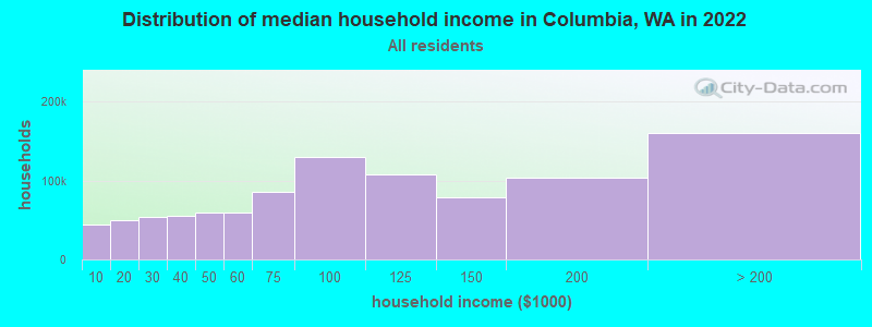
| Columbia: | $53,363 |
| WA: | $91,306 |
Estimated per capita income in 2022: $28,177 (it was $13,054 in 2000)
Columbia CCD income, earnings, and wages data
Estimated median house or condo value in 2022: $331,735 (it was $107,200 in 2000)
| Columbia: | $331,735 |
| WA: | $569,500 |
Detailed information about poverty and poor residents in Columbia, WA


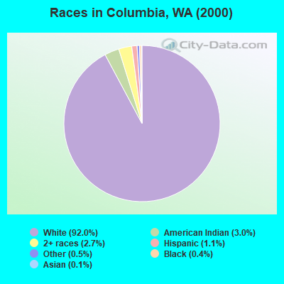
- 1,31292.0%White alone
- 433.0%American Indian alone
- 392.7%Two or more races
- 161.1%Hispanic
- 70.5%Other race alone
- 60.4%Black alone
- 20.1%Asian alone
- 10.07%Native Hawaiian and Other
Pacific Islander alone
Races in Columbia detailed stats: ancestries, foreign born residents, place of birth
 Recent articles from our blog. Our writers, many of them Ph.D. graduates or candidates, create easy-to-read articles on a wide variety of topics.
Current Local Time: PST time zone
Land area: 262.2 square miles.
Population density: 5.7 people per square mile (very low).

| Columbia CCD: | 0.5% ($547) |
| Washington: | 1.2% ($1,915) |
Nearest city with pop. 50,000+: Spokane, WA  (51.2 miles , pop. 195,629).
Nearest city with pop. 200,000+: East Seattle, WA (194.1 miles , pop. 480,100).
Nearest city with pop. 1,000,000+: Los Angeles, CA (980.3 miles , pop. 3,694,820).
Nearest cities:
), ), ), Latitude: 48.26 N, Longitude: 118.09 W
Area code: 509

| Here: | 7.1% |
| Washington: | 4.6% |
- Agriculture, forestry, fishing & hunting (18.9%)
- Educational services (11.7%)
- Construction (9.0%)
- Arts, entertainment, recreation (7.6%)
- Health care (5.7%)
- Wood products (5.3%)
- Public administration (4.7%)
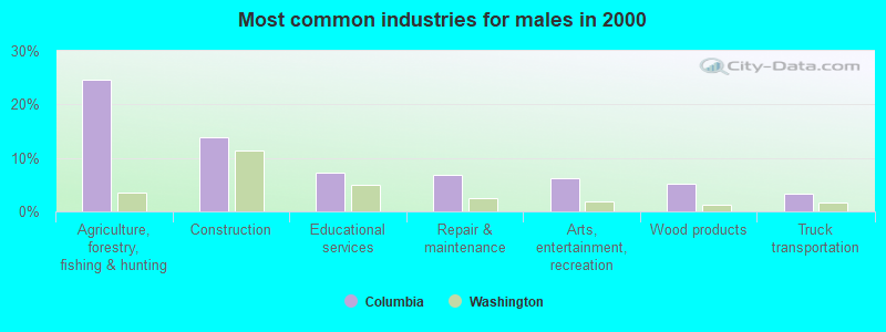
- Agriculture, forestry, fishing & hunting (24.7%)
- Construction (13.8%)
- Educational services (7.2%)
- Repair & maintenance (6.9%)
- Arts, entertainment, recreation (6.2%)
- Wood products (5.3%)
- Truck transportation (3.3%)
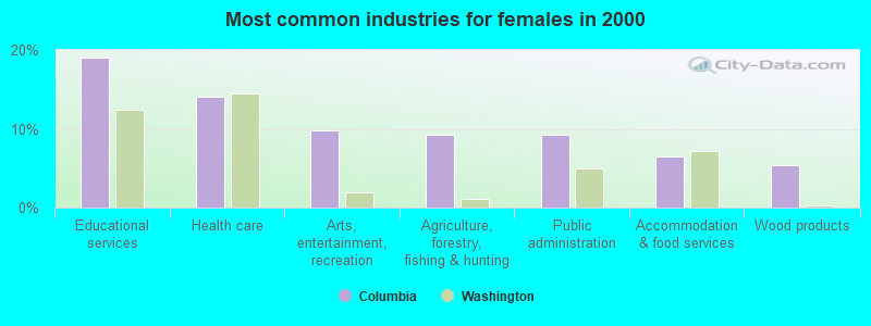
- Educational services (19.0%)
- Health care (14.1%)
- Arts, entertainment, recreation (9.8%)
- Agriculture, forestry, fishing & hunting (9.2%)
- Public administration (9.2%)
- Accommodation & food services (6.5%)
- Wood products (5.4%)
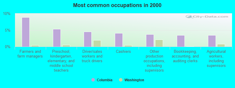
- Farmers and farm managers (8.8%)
- Preschool, kindergarten, elementary, and middle school teachers (5.3%)
- Driver/sales workers and truck drivers (4.5%)
- Cashiers (4.1%)
- Other production occupations, including supervisors (3.7%)
- Bookkeeping, accounting, and auditing clerks (3.5%)
- Agricultural workers, including supervisors (3.5%)

- Farmers and farm managers (10.9%)
- Driver/sales workers and truck drivers (6.6%)
- Construction traders workers except carpenters, electricians, painters, plumbers, and construction laborers (5.3%)
- Agricultural workers, including supervisors (4.9%)
- Metal workers and plastic workers (4.6%)
- Electrical equipment mechanics and other installation, maintenance, and repair workers, including supervisors (4.6%)
- Fishing, hunting, and forestry occupations (4.6%)
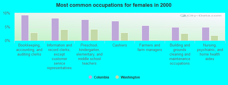
- Bookkeeping, accounting, and auditing clerks (9.2%)
- Information and record clerks, except customer service representatives (8.2%)
- Preschool, kindergarten, elementary, and middle school teachers (7.6%)
- Cashiers (7.1%)
- Farmers and farm managers (5.4%)
- Building and grounds cleaning and maintenance occupations (4.9%)
- Nursing, psychiatric, and home health aides (4.9%)
Average climate in Columbia, Washington
Based on data reported by over 4,000 weather stations


(lower is better)
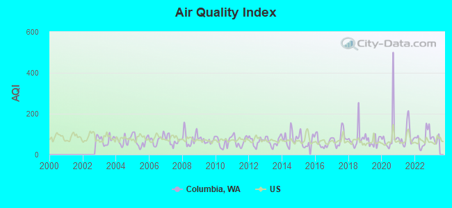
Air Quality Index (AQI) level in 2022 was 79.2. This is about average.
| City: | 79.2 |
| U.S.: | 72.6 |
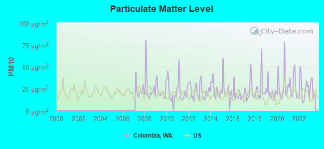
Particulate Matter (PM10) [µg/m3] level in 2022 was 24.3. This is worse than average. Closest monitor was 17.9 miles away from the city center.
| City: | 24.3 |
| U.S.: | 19.2 |
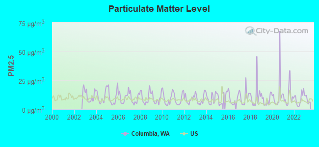
Particulate Matter (PM2.5) [µg/m3] level in 2022 was 9.19. This is about average. Closest monitor was 17.2 miles away from the city center.
| City: | 9.19 |
| U.S.: | 8.11 |
Earthquake activity:
Columbia-area historical earthquake activity is significantly above Washington state average. It is 922% greater than the overall U.S. average.On 4/13/1949 at 19:55:42, a magnitude 7.0 (7.0 UK, Class: Major, Intensity: VIII - XII) earthquake occurred 216.7 miles away from Columbia center, causing $80,000,000 total damage
On 2/28/2001 at 18:54:32, a magnitude 6.8 (6.5 MB, 6.6 MS, 6.8 MW, Class: Strong, Intensity: VII - IX) earthquake occurred 224.3 miles away from Columbia center, causing $2,000,000,000 total damage and $305,000,000 insured losses
On 2/28/2001 at 18:54:32, a magnitude 6.8 (6.8 MD, Depth: 32.2 mi) earthquake occurred 229.1 miles away from the city center
On 4/29/1965 at 15:28:43, a magnitude 6.6 (6.6 UK) earthquake occurred 207.7 miles away from Columbia center, causing $28,000,000 total damage
On 10/28/1983 at 14:06:06, a magnitude 7.3 (6.2 MB, 7.3 MS, 7.0 MW) earthquake occurred 354.5 miles away from Columbia center, causing 2 deaths (2 shaking deaths) and 3 injuries, causing $15,000,000 total damage
On 8/18/1959 at 06:37:13, a magnitude 7.7 (7.7 UK) earthquake occurred 436.5 miles away from the city center, causing $26,000,000 total damage
Magnitude types: body-wave magnitude (MB), duration magnitude (MD), surface-wave magnitude (MS), moment magnitude (MW)
Natural disasters:
The number of natural disasters in Stevens County (16) is near the US average (15).Major Disasters (Presidential) Declared: 11
Emergencies Declared: 3
Causes of natural disasters: Floods: 6, Fires: 5, Mudslides: 4, Storms: 3, Landslides: 2, Snows: 2, Winter Storms: 2, Drought: 1, Heavy Rain: 1, Hurricane: 1, Volcanic Eruption: 1, Wind: 1, Other: 1 (Note: some incidents may be assigned to more than one category).
Colleges/universities with over 2000 students nearest to Columbia:
- Whitworth University (about 47 miles; Spokane, WA; Full-time enrollment: 2,689)
- Spokane Falls Community College (about 50 miles; Spokane, WA; FT enrollment: 6,052)
- Gonzaga University (about 52 miles; Spokane, WA; FT enrollment: 6,780)
- Spokane Community College (about 53 miles; Spokane, WA; FT enrollment: 6,482)
- Eastern Washington University (about 58 miles; Cheney, WA; FT enrollment: 11,643)
- North Idaho College (about 72 miles; Coeur d'Alene, ID; FT enrollment: 4,684)
- Washington State University (about 115 miles; Pullman, WA; FT enrollment: 25,055)
Points of interest:
Notable locations in Columbia: Hunters Landing (A), Alyea (B), Gifford Ferry Landing (C), Gerome Landing (D), Hunters Landing (E), Gifford Campground (F), Cloverleaf Beach Campground (G), Greenwood Grange (H), Enterprise Camp (I), Stevens County Fire Protection District 12 Station 121 (J), Stevens County Fire District 2 Station 240 (K), Stevens County Fire District 2 Station 230 (L), Stevens County Fire District 2 Station 220 (M), Stevens County Fire District 2 Station 210 (N), Hunters Public Library (O). Display/hide their locations on the map
Churches in Columbia include: Enterprise Church (A), Cedonia Community Church (B), Columbia Heights Assembly Church (C), Advent Church (D). Display/hide their locations on the map
Cemeteries: Stranger Creek Cemetery (1), Enterprise Cemetery (2). Display/hide their locations on the map
Lakes and reservoirs: Clark Lake (A), Mudgett Lake (B), Newbill Lake (C), Mitchell Lake (D), Miller Reservoir (E), Hunters Pond (F), Snook Lake (G). Display/hide their locations on the map
Creeks: Deer Creek (A), Dunn Creek (B), Jennings Creek (C), Magee Creek (D), Smith Creek (E), Stranger Creek (F), Alder Creek (G), Harvey Creek (H), Hunter Creek (I). Display/hide their locations on the map
| This place: | 2.7 people |
| Washington: | 2.5 people |
| This place: | 63.6% |
| Whole state: | 66.5% |
| This place: | 5.1% |
| Whole state: | 6.1% |
Likely homosexual households (counted as self-reported same-sex unmarried-partner households)
- Lesbian couples: 0.4% of all households
- Gay men: 0.6% of all households
| This place: | 22.7% |
| Whole state: | 10.6% |
| This place: | 11.0% |
| Whole state: | 4.6% |
For population 15 years and over in Columbia:

- Never married: 19.9%
- Now married: 66.4%
- Separated: 1.1%
- Widowed: 4.9%
- Divorced: 8.8%
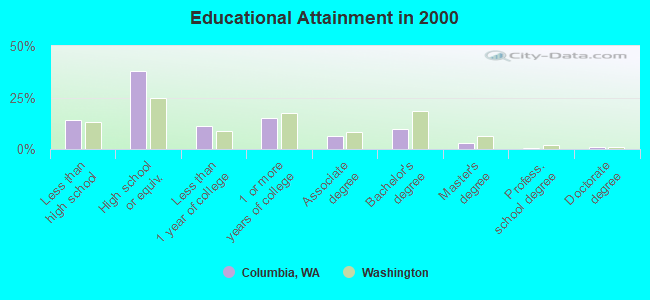
For population 25 years and over in Columbia:
- High school or higher: 85.8%
- Bachelor's degree or higher: 14.8%
- Graduate or professional degree: 4.9%
- Unemployed: 9.0%
- Mean travel time to work (commute): 27.3 minutes
| Here: | 9.7 |
| Washington average: | 11.3 |
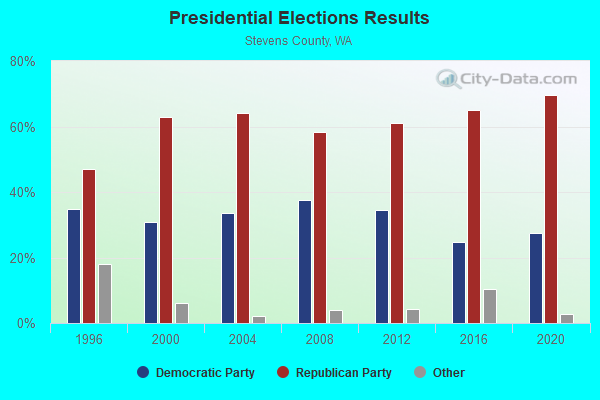
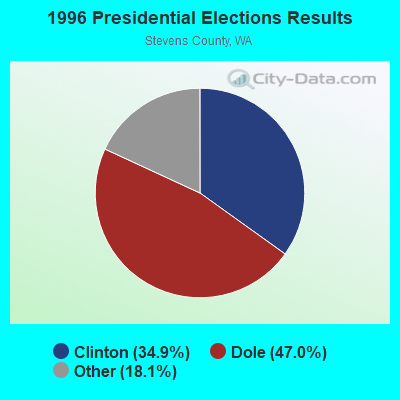
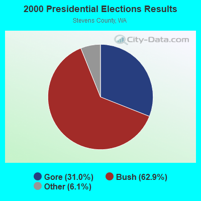
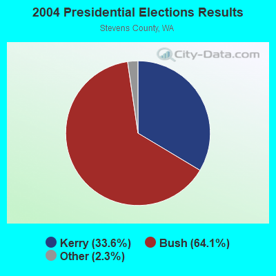

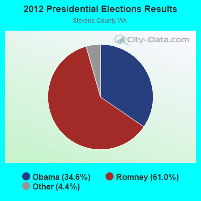

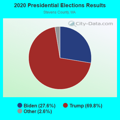
Graphs represent county-level data. Detailed 2008 Election Results
Religion statistics for Columbia, WA (based on Stevens County data)
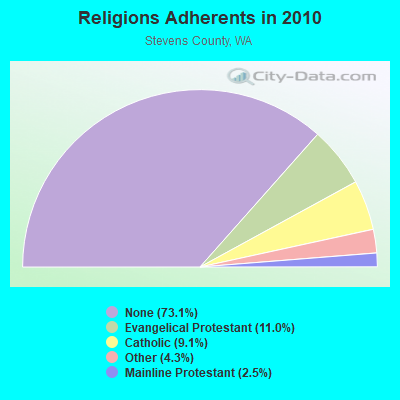
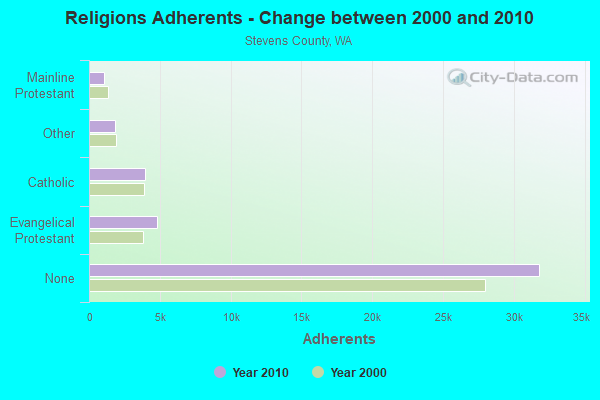
| Religion | Adherents | Congregations |
|---|---|---|
| Evangelical Protestant | 4,803 | 46 |
| Catholic | 3,974 | 10 |
| Other | 1,860 | 7 |
| Mainline Protestant | 1,094 | 8 |
| None | 31,800 | - |
Food Environment Statistics:
| Here: | 2.16 / 10,000 pop. |
| State: | 2.06 / 10,000 pop. |
| This county: | 0.24 / 10,000 pop. |
| Washington: | 0.19 / 10,000 pop. |
| Stevens County: | 1.20 / 10,000 pop. |
| Washington: | 1.18 / 10,000 pop. |
| Stevens County: | 2.64 / 10,000 pop. |
| Washington: | 2.67 / 10,000 pop. |
| Stevens County: | 6.95 / 10,000 pop. |
| Washington: | 8.26 / 10,000 pop. |
| This county: | 8.3% |
| Washington: | 7.7% |
| Here: | 27.0% |
| Washington: | 25.7% |
| Stevens County: | 10.8% |
| Washington: | 13.9% |
Strongest AM radio stations in Columbia:
- KGA (1510 AM; 50 kW; SPOKANE, WA; Owner: CITADEL BROADCASTING COMPANY)
- KTBI (810 AM; daytime; 50 kW; EPHRATA, WA; Owner: TACOMA BROADCASTERS, INCORPORATED)
- KXLY (920 AM; 20 kW; SPOKANE, WA; Owner: SPOKANE RADIO, INC.)
- KMJY (700 AM; 10 kW; NEWPORT, WA; Owner: JAMES E. AND HELEN G. STARGEL)
- KQNT (590 AM; 5 kW; SPOKANE, WA; Owner: CAPSTAR TX LIMITED PARTNERSHIP)
- KCVL (1240 AM; 1 kW; COLVILLE, WA; Owner: NORTH COUNTRY BROADCASTING)
- KJRB (790 AM; 5 kW; SPOKANE, WA; Owner: CITADEL BROADCASTING COMPANY)
- KERR (750 AM; 50 kW; POLSON, MT; Owner: ANDERSON RADIO BROADCASTING, INC.)
- KQQQ (1150 AM; 25 kW; PULLMAN, WA; Owner: RADIO PALOUSE, INC.)
- KTRW (970 AM; 5 kW; SPOKANE, WA; Owner: KTRW, LLC)
- KOMW (680 AM; daytime; 5 kW; OMAK, WA; Owner: NORTH CASCADES BROADCASTING, INC.)
- KVNI (1080 AM; 10 kW; COEUR D' ALENE, ID; Owner: QUEENB RADIO, INC.)
- KIRO (710 AM; 50 kW; SEATTLE, WA; Owner: ENTERCOM SEATTLE LICENSE, LLC)
Strongest FM radio stations in Columbia:
- KMJY-FM (104.5 FM; NEWPORT, WA; Owner: ALC COMMUNICATIONS)
- KXLY-FM (99.9 FM; SPOKANE, WA; Owner: SPOKANE RADIO, INC.)
- K219DQ (90.5 FM; OMAK, WA; Owner: WALLA WALLA COLLEGE)
- KZZU-FM (92.9 FM; SPOKANE, WA; Owner: QUEENB)
- KCDA (103.1 FM; POST FALLS, ID; Owner: CAPSTAR TX LIMITED PARTNERSHIP)
- KDRK-FM (93.7 FM; SPOKANE, WA; Owner: CITADEL BROADCASTING COMPANY)
- KIXZ-FM (96.1 FM; OPPORTUNITY, WA; Owner: CAPSTAR TX LIMITED PARTNERSHIP)
- KPND (95.3 FM; SANDPOINT, ID; Owner: BLUE SKY BROADCASTING INC.)
- KMBI-FM (107.9 FM; SPOKANE, WA; Owner: THE MOODY BIBLE INSTITUTE OF CHICAGO)
- KPBX-FM (91.1 FM; SPOKANE, WA; Owner: SPOKANE PUBLIC RADIO, INC.)
- KISC (98.1 FM; SPOKANE, WA; Owner: CAPSTAR TX LIMITED PARTNERSHIP)
- KEYF-FM (101.1 FM; CHENEY, WA; Owner: CITADEL BROADCASTING COMPANY)
- KEYG-FM (98.5 FM; GRAND COULEE, WA; Owner: WHEELER BROADCASTING, INC.)
- KZBD (105.7 FM; SPOKANE, WA; Owner: CITADEL BROADCASTING COMPANY)
- KAGU (88.7 FM; SPOKANE, WA; Owner: GONZAGA UNIVERSITY TELECOMMUNICATIONS ASSOCIATION)
- KCRK-FM (92.1 FM; COLVILLE, WA; Owner: NORTH COUNTRY BROADCASTING)
TV broadcast stations around Columbia:
- K59BW (Channel 59; BONNERS FERRY, ID; Owner: STATE BOARD OF EDUCATION (IEPBS))
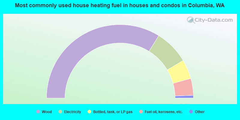
- 67.7%Wood
- 15.2%Electricity
- 8.5%Bottled, tank, or LP gas
- 7.4%Fuel oil, kerosene, etc.
- 0.7%Other fuel
- 0.5%No fuel used
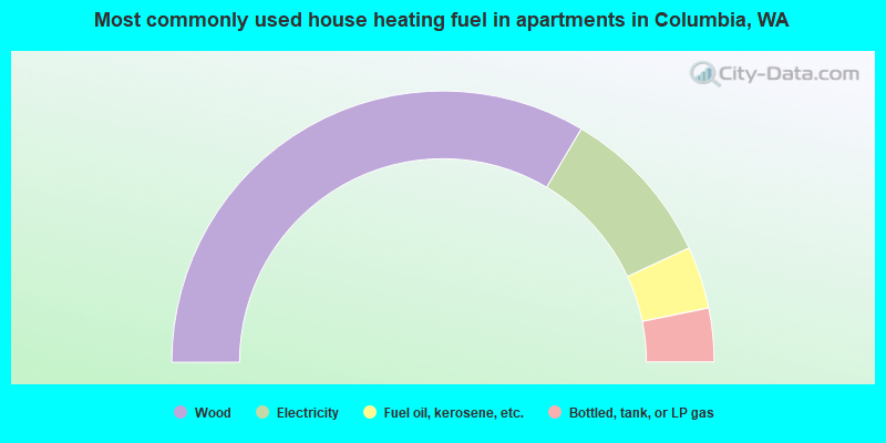
- 67.0%Wood
- 19.1%Electricity
- 7.4%Fuel oil, kerosene, etc.
- 6.4%Bottled, tank, or LP gas
Columbia compared to Washington state average:
- Median household income below state average.
- Median house value below state average.
- Black race population percentage significantly below state average.
- Hispanic race population percentage significantly below state average.
- Median age significantly above state average.
- Foreign-born population percentage significantly below state average.
- Renting percentage significantly below state average.
- Length of stay since moving in significantly above state average.
- Number of rooms per house significantly below state average.
- House age significantly below state average.
- Number of college students significantly below state average.
- Percentage of population with a bachelor's degree or higher below state average.

|
Total of 1 patent application in 2008-2024.