Clark Canyon-Horse Prairie, Montana
Submit your own pictures of this place and show them to the world
- OSM Map
- Google Map
- MSN Map
| Males: 232 | |
| Females: 202 |
| Median resident age: | 35.2 years |
| Montana median age: | 37.5 years |
Zip code: 59725
| Clark Canyon-Horse Prairie: | $48,615 |
| MT: | $67,631 |
Estimated per capita income in 2022: $22,989 (it was $10,234 in 2000)
Clark Canyon-Horse Prairie CCD income, earnings, and wages data
Estimated median house or condo value in 2022: $492,802 (it was $127,500 in 2000)
| Clark Canyon-Horse Prairie: | $492,802 |
| MT: | $366,400 |
Clark Canyon-Horse Prairie, MT residents, houses, and apartments details
Detailed information about poverty and poor residents in Clark Canyon-Horse Prairie, MT


- 41692.2%White alone
- 286.2%Hispanic
- 51.1%American Indian alone
- 20.4%Other race alone

 Recent articles from our blog. Our writers, many of them Ph.D. graduates or candidates, create easy-to-read articles on a wide variety of topics.
Current Local Time: MST time zone
Land area: 1248.7 square miles.
Population density: 0.3 people per square mile (very low).
| Clark Canyon-Horse Prairie CCD: | 0.5% ($650) |
| Montana: | 1.3% ($1,212) |
Nearest city with pop. 50,000+: Idaho Falls, ID  (114.0 miles , pop. 50,730).
Nearest city with pop. 200,000+: Northwest Clackamas, OR (465.6 miles , pop. 224,220).
Nearest city with pop. 1,000,000+: Phoenix, AZ (792.3 miles , pop. 1,321,045).
Nearest cities:
), ), Latitude: 44.96 N, Longitude: 113.08 W

| Here: | 3.2% |
| Montana: | 3.8% |

- Agriculture, forestry, fishing & hunting (59.9%)
- Accommodation & food services (8.3%)
- Educational services (5.7%)
- Public administration (3.6%)
- Personal & laundry services (3.6%)
- Farm supplies merchant wholesalers (3.1%)
- Farm product raw materials merchant wholesalers (2.1%)

- Agriculture, forestry, fishing & hunting (71.1%)
- Farm supplies merchant wholesalers (4.7%)
- Accommodation & food services (4.7%)
- Personal & laundry services (4.7%)
- Educational services (3.9%)
- Construction (1.6%)
- Building material & garden equipment & supplies dealers (1.6%)

- Agriculture, forestry, fishing & hunting (37.5%)
- Accommodation & food services (15.6%)
- Educational services (9.4%)
- Public administration (7.8%)
- Farm product raw materials merchant wholesalers (6.2%)
- Health care (6.2%)
- Food & beverage stores (3.1%)

- Farmers and farm managers (31.8%)
- Agricultural workers, including supervisors (25.5%)
- Sales representatives, services, wholesale and manufacturing (5.2%)
- Waiters and waitresses (3.6%)
- Cooks and food preparation workers (3.6%)
- Building and grounds cleaning and maintenance occupations (3.1%)
- Other sales and related occupations, including supervisors (3.1%)

- Farmers and farm managers (43.8%)
- Agricultural workers, including supervisors (27.3%)
- Sales representatives, services, wholesale and manufacturing (6.2%)
- Building and grounds cleaning and maintenance occupations (4.7%)
- Other management occupations, except farmers and farm managers (3.1%)
- Preschool, kindergarten, elementary, and middle school teachers (2.3%)
- Other protective service workers, including supervisors (1.6%)

- Agricultural workers, including supervisors (21.9%)
- Cooks and food preparation workers (10.9%)
- Waiters and waitresses (10.9%)
- Information and record clerks, except customer service representatives (7.8%)
- Farmers and farm managers (7.8%)
- Cashiers (6.2%)
- Other sales and related occupations, including supervisors (6.2%)
Average climate in Clark Canyon-Horse Prairie, Montana
Based on data reported by over 4,000 weather stations


Earthquake activity:
Clark Canyon-Horse Prairie-area historical earthquake activity is significantly above Montana state average. It is 1124% greater than the overall U.S. average.On 8/18/1959 at 06:37:13, a magnitude 7.7 (7.7 UK, Class: Major, Intensity: VIII - XII) earthquake occurred 122.3 miles away from Clark Canyon-Horse Prairie center, causing $26,000,000 total damage
On 10/28/1983 at 14:06:06, a magnitude 7.3 (6.2 MB, 7.3 MS, 7.0 MW) earthquake occurred 70.4 miles away from Clark Canyon-Horse Prairie center, causing 2 deaths (2 shaking deaths) and 3 injuries, causing $15,000,000 total damage
On 3/31/2020 at 23:52:30, a magnitude 6.5 (6.5 MW, Depth: 7.5 mi, Class: Strong, Intensity: VII - IX) earthquake occurred 105.6 miles away from Clark Canyon-Horse Prairie center
On 10/3/1915 at 06:52:48, a magnitude 7.6 (7.6 UK) earthquake occurred 381.1 miles away from the city center
On 6/30/1975 at 18:54:13, a magnitude 6.1 (5.6 MB, 5.9 MS, 6.1 UK, 6.1 ML) earthquake occurred 116.8 miles away from Clark Canyon-Horse Prairie center
On 8/22/1984 at 09:46:30, a magnitude 5.8 (5.0 MB, 5.1 MS, 5.8 ML, Class: Moderate, Intensity: VI - VII) earthquake occurred 53.3 miles away from the city center
Magnitude types: body-wave magnitude (MB), local magnitude (ML), surface-wave magnitude (MS), moment magnitude (MW)
Natural disasters:
The number of natural disasters in Beaverhead County (4) is a lot smaller than the US average (15).Major Disasters (Presidential) Declared: 1
Emergencies Declared: 1
Causes of natural disasters: Fires: 2, Hurricane: 1, Other: 1 (Note: some incidents may be assigned to more than one category).
Colleges/universities with over 2000 students nearest to Clark Canyon-Horse Prairie:
- Brigham Young University-Idaho (about 102 miles; Rexburg, ID; Full-time enrollment: 30,522)
- Montana State University (about 111 miles; Bozeman, MT; FT enrollment: 12,942)
- The University of Montana (about 139 miles; Missoula, MT; FT enrollment: 13,602)
- Idaho State University (about 149 miles; Pocatello, ID; FT enrollment: 10,350)
- College of Southern Idaho (about 179 miles; Twin Falls, ID; FT enrollment: 5,051)
- Boise State University (about 181 miles; Boise, ID; FT enrollment: 16,774)
- College of Western Idaho (about 194 miles; Nampa, ID; FT enrollment: 6,300)
Points of interest:
Notable locations in Clark Canyon-Horse Prairie: McMenomey Ranch (A), Bannack Bench Windmill (B), Bloody Dick Guard Station (C), Mansfield Cow Camp (D), Briggs Ranch (E), Keystone Drift Fence (F), Cross Ranch (G), Peterson Ranch (H), Pierce Ranch (I), Sacajawea Memorial Camp (J), Selway Ranch (K), Henneberry Ranch (L), High Bridge Fishing Access Site (M), Henneberry Fishing Access Site (N), Donovan Ranch (O), Christensen Ranch (P), Hansen Ranch (Q), LC Cow Camp (R), Kidd (S), Horse Prairie Guard Station (T). Display/hide their locations on the map
Lakes, reservoirs, and swamps: Lovells Lake (A), Dad Creek Lake (B), Selway Lake (C), Poison Lakes (D), Lake Canyon Lake (E), Harrison Lake (F), Horseshoe Lake (G), Goldstone Lake (H). Display/hide their locations on the map
Rivers and creeks: Browns Creek (A), Trail Creek (B), Alkali Creek (C), Noble Creek (D), Anton Creek (E), Barrett Creek (F), Bear Creek (G), Bill Hill Creek (H), Black Canyon Creek (I). Display/hide their locations on the map
Parks in Clark Canyon-Horse Prairie include: Clark Canyon Reservoir Recreational Area (1), Bannack State Park (2), Old Trail to the Gold Diggins Historical Marker (3), Dell Park (4). Display/hide their locations on the map
| This place: | 2.4 people |
| Montana: | 2.4 people |
| This place: | 66.0% |
| Whole state: | 62.8% |
| This place: | 4.4% |
| Whole state: | 6.7% |
No gay or lesbian households reported
| This place: | 29.5% |
| Whole state: | 14.6% |
| This place: | 14.3% |
| Whole state: | 5.8% |
For population 15 years and over in Clark Canyon-Horse Prairie:

- Never married: 22.0%
- Now married: 70.5%
- Separated: 0.9%
- Widowed: 2.4%
- Divorced: 5.1%
For population 25 years and over in Clark Canyon-Horse Prairie:
- High school or higher: 82.2%
- Bachelor's degree or higher: 23.4%
- Graduate or professional degree: 6.3%
- Unemployed: 2.5%
- Mean travel time to work (commute): 10.8 minutes


| Here: | 11.3 |
| Montana average: | 10.4 |
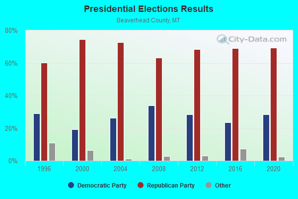
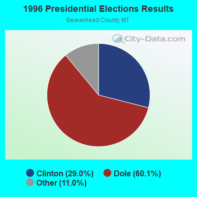
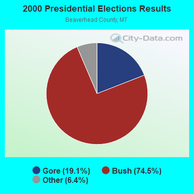
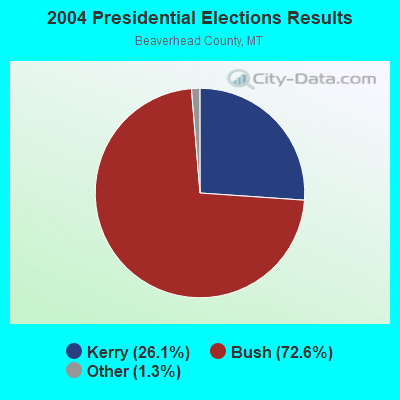
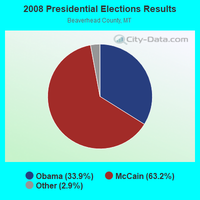


Graphs represent county-level data. Detailed 2008 Election Results
Religion statistics for Clark Canyon-Horse Prairie, MT (based on Beaverhead County data)
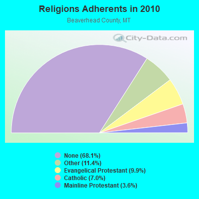
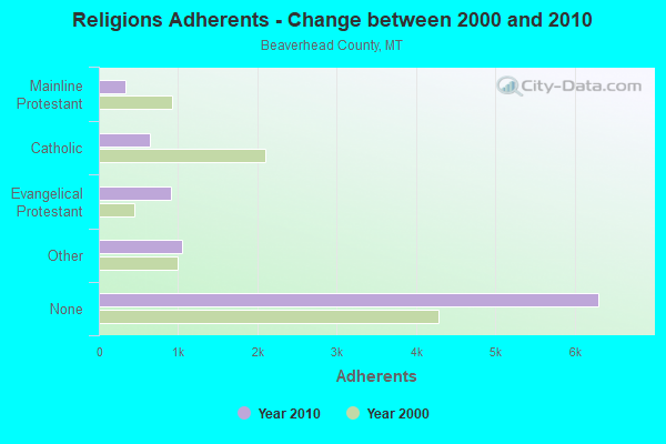
| Religion | Adherents | Congregations |
|---|---|---|
| Other | 1,052 | 5 |
| Evangelical Protestant | 911 | 10 |
| Catholic | 650 | 3 |
| Mainline Protestant | 332 | 5 |
| None | 6,301 | - |
Food Environment Statistics:
| Beaverhead County: | 3.41 / 10,000 pop. |
| Montana: | 2.55 / 10,000 pop. |
| Here: | 5.68 / 10,000 pop. |
| Montana: | 4.69 / 10,000 pop. |
| Here: | 18.17 / 10,000 pop. |
| Montana: | 10.38 / 10,000 pop. |
| Beaverhead County: | 8.4% |
| Montana: | 7.2% |
| Beaverhead County: | 23.0% |
| Montana: | 23.1% |
| Beaverhead County: | 7.6% |
| State: | 10.7% |
Strongest AM radio stations in Clark Canyon-Horse Prairie:
- KBOI (670 AM; 50 kW; BOISE, ID; Owner: CITADEL BROADCASTING COMPANY)
- KERR (750 AM; 50 kW; POLSON, MT; Owner: ANDERSON RADIO BROADCASTING, INC.)
- KBOW (550 AM; 5 kW; BUTTE, MT; Owner: BUTTE BROADCASTING INCORPORATED)
- KGVW (640 AM; 10 kW; BELGRADE, MT; Owner: GALLATIN VALLEY WITNESS, INC.)
- KWEI (1260 AM; 50 kW; WEISER, ID; Owner: TREASURE VALLEY BROADCASTING CO.)
- KZNR (690 AM; 10 kW; BLACKFOOT, ID; Owner: WESTERN COMMUNICATIONS, INC.)
- KALL (700 AM; 50 kW; NORTH SALT LAKE CITY, UT; Owner: CITICASTERS LICENSES, L.P.)
- KDBM (1490 AM; 1 kW; DILLON, MT; Owner: DEAD-AIR BROADCASTING COMPANY, INC.)
- KOFI (1180 AM; 50 kW; KALISPELL, MT; Owner: KOFI, INC.)
- KXTL (1370 AM; 5 kW; BUTTE, MT; Owner: FISHER RADIO REGIONAL GROUP, INC.)
- KID (590 AM; 5 kW; IDAHO FALLS, ID; Owner: CITICASTERS LICENSES, L.P.)
- KSRA (960 AM; 1 kW; SALMON, ID; Owner: SALMON RIVER COMMUNICATIONS, INC.)
- KIQN (1010 AM; 50 kW; TOOELE, UT)
Strongest FM radio stations in Clark Canyon-Horse Prairie:
- K204CC (88.7 FM; CHALLIS, ETC., ID; Owner: CHALLIS MISSION CHURCH)
- KBEV-FM (98.3 FM; DILLON, MT; Owner: DEAD-AIR BROADCASTING COMPANY, INC.)

- 48.3%Bottled, tank, or LP gas
- 25.8%Wood
- 11.2%Electricity
- 7.9%Fuel oil, kerosene, etc.
- 4.5%Other fuel
- 2.2%Utility gas

- 40.0%Bottled, tank, or LP gas
- 24.0%Electricity
- 24.0%Wood
- 9.3%Fuel oil, kerosene, etc.
- 2.7%Utility gas
Clark Canyon-Horse Prairie compared to Montana state average:
- Unemployed percentage significantly below state average.
- Black race population percentage significantly below state average.
- Foreign-born population percentage significantly below state average.
- Length of stay since moving in significantly above state average.
- Number of rooms per house significantly below state average.
- House age significantly below state average.
- Number of college students significantly below state average.