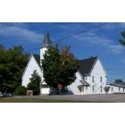
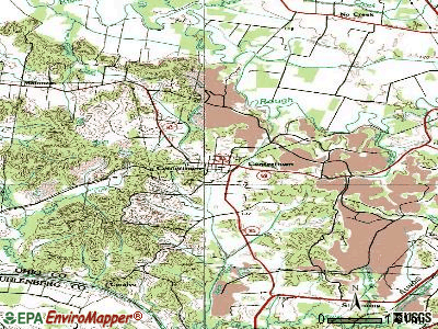
Centertown, Kentucky
Submit your own pictures of this city and show them to the world
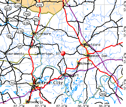
- OSM Map
- General Map
- Google Map
- MSN Map
Population change since 2000: -1.4%
 |
| Males: 210 | |
| Females: 200 |
| Median resident age: | 40.2 years |
| Kentucky median age: | 39.4 years |
Zip codes: 42328.
| Centertown: | $44,679 |
| KY: | $59,341 |
Estimated per capita income in 2022: $20,767 (it was $13,018 in 2000)
Centertown city income, earnings, and wages data
Estimated median house or condo value in 2022: $94,268 (it was $37,900 in 2000)
| Centertown: | $94,268 |
| KY: | $196,300 |
Mean prices in 2022: all housing units: $83,574; detached houses: $92,500; mobile homes: $50,599
Median gross rent in 2022: $862.
(26.9% for White Non-Hispanic residents, 100.0% for Black residents)
Detailed information about poverty and poor residents in Centertown, KY
Compare current foreclosures near Centertown, KY:
| Photo | Address | Area | Beds / Baths | Price | Details |
|---|---|---|---|---|---|

|
#1
State Route 85 E
Centertown, KY 42328
|
- sq. feet
|
- baths - beds |
show details | |

|
#2
Willow Glen Rd
Central City, KY 42330
|
1,100 sq. feet
|
1 baths 3 beds |
show details | |

|
#3
Us Highway 62 W
Rockport, KY 42369
|
1,225 sq. feet
|
1 baths 3 beds |
show details | |

|
#4
Sycamore Dr
Livermore, KY 42352
|
2,376 sq. feet
|
2 baths 3 beds |
show details | |

|
#5
State Route 70 W
Central City, KY 42330
|
- sq. feet
|
1 baths 3 beds |
show details | |

|
#6
Reynolds Ln
Sacramento, KY 42372
|
1,496 sq. feet
|
1 baths 4 beds |
show details | |

|
#7
Greenbriar Rd
Utica, KY 42376
|
2,476 sq. feet
|
2 baths 3 beds |
show details | |

|
#8
Richland Rd
Calhoun, KY 42327
|
756 sq. feet
|
1 baths 3 beds |
show details | |

|
#9
Greenbriar Rd
Utica, KY 42376
|
- sq. feet
|
- baths - beds |
show details | |

|
#10
E Harmons Ferry Rd
Utica, KY 42376
|
1,680 sq. feet
|
- baths - beds |
show details |
| Photo | Address | Area | Beds / Baths | Price | Details |
|---|---|---|---|---|---|

|
#11
Craig Rd
Sacramento, KY 42372
|
- sq. feet
|
- baths - beds |
show details | |

|
#12
Lee Dr
Beaver Dam, KY 42320
|
- sq. feet
|
- baths - beds |
show details | |

|
#13
W Reservoir Ave
Central City, KY 42330
|
- sq. feet
|
- baths - beds |
show details | |

|
#14
Taylors Lake Rd
Morgantown, KY 42261
|
- sq. feet
|
- baths - beds |
show details | |

|
#15
Phillip Stone Way Lot 53
Central City, KY 42330
|
- sq. feet
|
- baths - beds |
show details | |

|
#16
Wilhite Ln
Utica, KY 42376
|
- sq. feet
|
- baths - beds |
show details | |

|
#17
Kentucky 269
Beaver Dam, KY 42320
|
- sq. feet
|
- baths - beds |
show details | |

|
#18
W Mose Rager Blvd
Drakesboro, KY 42337
|
- sq. feet
|
- baths - beds |
show details | |

|
#19
State Route 70 W
Bremen, KY 42325
|
- sq. feet
|
- baths - beds |
show details | |

|
#20
Us Highway 431
Utica, KY 42376
|
- sq. feet
|
- baths - beds |
show details |
| Photo | Address | Area | Beds / Baths | Price | Details |
|---|---|---|---|---|---|

|
#21
Obannon Ln
Central City, KY 42330
|
- sq. feet
|
- baths - beds |
show details | |

|
#22
Us Highway 431 S
Beechmont, KY 42323
|
- sq. feet
|
- baths - beds |
show details | |

|
#23
Harris Rd
Belton, KY 42324
|
1,040 sq. feet
|
- baths - beds |
show details | |

|
#24
Beech Grove St
Calhoun, KY 42327
|
- sq. feet
|
- baths - beds |
show details | |

|
#25
Walnut St
Calhoun, KY 42327
|
- sq. feet
|
- baths - beds |
show details | |

|
#26
State Route 70 W
Bremen, KY 42325
|
- sq. feet
|
- baths - beds |
show details | |

|
#27
Hill Rd
Belton, KY 42324
|
- sq. feet
|
- baths - beds |
show details | |

|
#28
E 2nd St
Calhoun, KY 42327
|
- sq. feet
|
- baths - beds |
show details | |

|
#29
Salem Rd
Olaton, KY 42361
|
- sq. feet
|
- baths - beds |
show details | |

|
#30
State Route 1207
Utica, KY 42376
|
- sq. feet
|
- baths - beds |
show details |
| Photo | Address | Area | Beds / Baths | Price | Details |
|---|---|---|---|---|---|

|
#31
Kentucky 1414
Whitesville, KY 42378
|
- sq. feet
|
- baths - beds |
show details | |

|
#32
Willis Dr
Powderly, KY 42367
|
- sq. feet
|
- baths - beds |
show details | |

|
#33
Red Bud Ln
Powderly, KY 42367
|
- sq. feet
|
- baths - beds |
show details | |

|
#34
Pendley St
Powderly, KY 42367
|
- sq. feet
|
- baths - beds |
show details | |

|
#35
Chestnut St Lot C
Sacramento, KY 42372
|
- sq. feet
|
- baths - beds |
show details | |

|
#36
Cleaton Rd Apt 3
Central City, KY 42330
|
- sq. feet
|
- baths - beds |
show details | |

|
#37
Reynolds St
Central City, KY 42330
|
924 sq. feet
|
- baths - beds |
show details | |

|
#38
Taffy Rd
Hartford, KY 42347
|
- sq. feet
|
- baths - beds |
show details | |

|
#39
Rochester Rd
Beaver Dam, KY 42320
|
- sq. feet
|
- baths - beds |
show details | |

|
#40
Barnard Ct
Beaver Dam, KY 42320
|
- sq. feet
|
- baths - beds |
show details |
| Photo | Address | Area | Beds / Baths | Price | Details |
|---|---|---|---|---|---|

|
#41
Mapleleaf Dr
Utica, KY 42376
|
- sq. feet
|
- baths - beds |
show details | |

|
#42
E Render St
Hartford, KY 42347
|
- sq. feet
|
- baths - beds |
show details | |

|
#43
Embry Heights Dr
Beaver Dam, KY 42320
|
- sq. feet
|
- baths - beds |
show details | |

|
#44
Bruce School Rd
Beaver Dam, KY 42320
|
- sq. feet
|
- baths - beds |
show details | |

|
#45
Old Main St
Hartford, KY 42347
|
- sq. feet
|
- baths - beds |
show details | |

|
#46
Burge Ln
Beaver Dam, KY 42320
|
- sq. feet
|
- baths - beds |
show details | |

|
#47
W 1st St
Beaver Dam, KY 42320
|
- sq. feet
|
- baths - beds |
show details | |

|
#48
Silver Beach Rd
Hartford, KY 42347
|
- sq. feet
|
- baths - beds |
show details | |

|
#49
Kentucky 1414
Hartford, KY 42347
|
- sq. feet
|
- baths - beds |
show details | |

|
Check over 1 million property listings on Foreclosure.com!
|
browse all offers | |||


- 39690.8%White alone
- 388.7%Two or more races
- 61.4%Asian alone
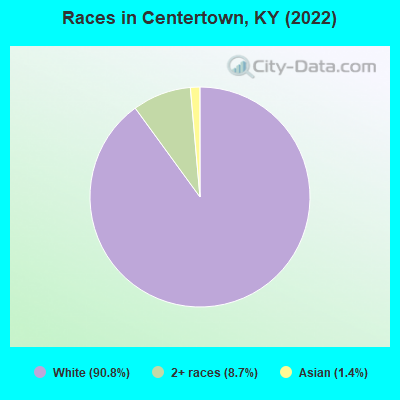
Races in Centertown detailed stats: ancestries, foreign born residents, place of birth
According to our research of Kentucky and other state lists, there were 2 registered sex offenders living in Centertown, Kentucky as of May 23, 2024.
The ratio of all residents to sex offenders in Centertown is 222 to 1.
Type |
2011 |
2012 |
2014 |
2015 |
2016 |
2018 |
2020 |
2022 |
|---|---|---|---|---|---|---|---|---|
| Murders (per 100,000) | 0 (0.0) | 0 (0.0) | 0 (0.0) | 0 (0.0) | 0 (0.0) | 0 (0.0) | 0 (0.0) | 0 (0.0) |
| Rapes (per 100,000) | 0 (0.0) | 0 (0.0) | 0 (0.0) | 0 (0.0) | 0 (0.0) | 0 (0.0) | 0 (0.0) | 0 (0.0) |
| Robberies (per 100,000) | 0 (0.0) | 0 (0.0) | 0 (0.0) | 0 (0.0) | 0 (0.0) | 0 (0.0) | 0 (0.0) | 0 (0.0) |
| Assaults (per 100,000) | 0 (0.0) | 0 (0.0) | 0 (0.0) | 0 (0.0) | 0 (0.0) | 0 (0.0) | 0 (0.0) | 0 (0.0) |
| Burglaries (per 100,000) | 0 (0.0) | 0 (0.0) | 0 (0.0) | 0 (0.0) | 0 (0.0) | 1 (229.4) | 0 (0.0) | 0 (0.0) |
| Thefts (per 100,000) | 1 (234.7) | 1 (233.1) | 1 (224.7) | 1 (226.8) | 1 (225.2) | 1 (229.4) | 1 (233.1) | 1 (241.5) |
| Auto thefts (per 100,000) | 0 (0.0) | 0 (0.0) | 0 (0.0) | 0 (0.0) | 0 (0.0) | 0 (0.0) | 0 (0.0) | 1 (241.5) |
| Arson (per 100,000) | 0 (0.0) | 0 (0.0) | 0 (0.0) | 0 (0.0) | 0 (0.0) | 0 (0.0) | 0 (0.0) | 0 (0.0) |
| City-Data.com crime index | 9.4 | 9.3 | 9.0 | 9.1 | 9.0 | 25.2 | 9.3 | 29.0 |
The City-Data.com crime index weighs serious crimes and violent crimes more heavily. Higher means more crime, U.S. average is 246.1. It adjusts for the number of visitors and daily workers commuting into cities.

Crime rate in Centertown detailed stats: murders, rapes, robberies, assaults, burglaries, thefts, arson
Full-time law enforcement employees in 2021, including police officers: 1 (1 officers - 1 male; 0 female).
| Officers per 1,000 residents here: | 2.33 |
| Kentucky average: | 1.89 |
 Recent articles from our blog. Our writers, many of them Ph.D. graduates or candidates, create easy-to-read articles on a wide variety of topics.

 | Rural KY photo "sticky" (336 replies) |
| Western Kentucky (Ohio County) Jobs Progress! (0 replies) |
Latest news from Centertown, KY collected exclusively by city-data.com from local newspapers, TV, and radio stations
Ancestries: American (67.4%), Irish (9.7%), English (9.0%), European (1.9%), German (1.1%).
Current Local Time: CST time zone
Incorporated on 02/11/1890
Elevation: 424 feet
Land area: 0.31 square miles.
Population density: 1,337 people per square mile (low).
3 residents are foreign born
| This city: | 0.7% |
| Kentucky: | 4.1% |
| Centertown city: | 0.7% ($261) |
| Kentucky: | 0.8% ($610) |
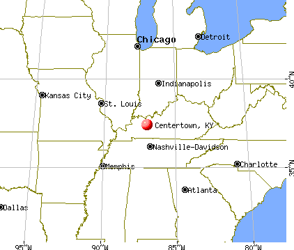
Nearest city with pop. 50,000+: Owensboro, KY  (24.5 miles , pop. 54,067).
Nearest city with pop. 200,000+: Metropolitan Government, TN (88.1 miles , pop. 569,891).
Nearest city with pop. 1,000,000+: Chicago, IL (308.1 miles , pop. 2,896,016).
Nearest cities:
), ), ), Latitude: 37.42 N, Longitude: 87.00 W
Area code: 270


| Here: | 5.7% |
| Kentucky: | 3.8% |

- Construction (14.6%)
- Health care (14.0%)
- Metal & metal products (11.2%)
- Educational services (7.9%)
- Accommodation & food services (6.2%)
- Food (3.9%)
- Furniture & related product manufacturing (3.9%)

- Construction (24.2%)
- Metal & metal products (22.0%)
- Mining, quarrying, oil & gas extraction (6.6%)
- Furniture & related product manufacturing (5.5%)
- Food & beverage stores (4.4%)
- Truck transportation (4.4%)
- Administrative & support & waste management services (4.4%)

- Health care (28.7%)
- Educational services (13.8%)
- Accommodation & food services (9.2%)
- Public administration (8.0%)
- Construction (4.6%)
- Food (4.6%)
- Department & other general merchandise stores (3.4%)

- Construction traders workers except carpenters, electricians, painters, plumbers, and construction laborers (8.4%)
- Metal workers and plastic workers (7.9%)
- Other production occupations, including supervisors (7.3%)
- Other material moving workers, except laborers (5.6%)
- Other sales and related occupations, including supervisors (5.6%)
- Construction laborers (4.5%)
- Cooks and food preparation workers (3.9%)

- Metal workers and plastic workers (15.4%)
- Construction traders workers except carpenters, electricians, painters, plumbers, and construction laborers (14.3%)
- Other material moving workers, except laborers (9.9%)
- Construction laborers (8.8%)
- Other production occupations, including supervisors (8.8%)
- Vehicle and mobile equipment mechanics, installers, and repairers (6.6%)
- Cashiers (4.4%)

- Health technologists and technicians (8.0%)
- Nursing, psychiatric, and home health aides (8.0%)
- Other sales and related occupations, including supervisors (8.0%)
- Retail sales workers, except cashiers (6.9%)
- Other management occupations, except farmers and farm managers (5.7%)
- Other production occupations, including supervisors (5.7%)
- Other office and administrative support workers, including supervisors (5.7%)
Average climate in Centertown, Kentucky
Based on data reported by over 4,000 weather stations


(lower is better)

Air Quality Index (AQI) level in 2005 was 88.0. This is worse than average.
| City: | 88.0 |
| U.S.: | 72.6 |

Nitrogen Dioxide (NO2) [ppb] level in 2001 was 5.36. This is about average. Closest monitor was 7.3 miles away from the city center.
| City: | 5.36 |
| U.S.: | 5.11 |

Sulfur Dioxide (SO2) [ppb] level in 2001 was 2.52. This is significantly worse than average. Closest monitor was 3.9 miles away from the city center.
| City: | 2.52 |
| U.S.: | 1.51 |

Ozone [ppb] level in 2005 was 35.1. This is about average. Closest monitor was 7.3 miles away from the city center.
| City: | 35.1 |
| U.S.: | 33.3 |
Tornado activity:
Centertown-area historical tornado activity is slightly above Kentucky state average. It is 53% greater than the overall U.S. average.
On 4/3/1974, a category F5 (max. wind speeds 261-318 mph) tornado 33.5 miles away from the Centertown city center killed 31 people and injured 270 people and caused between $500,000 and $5,000,000 in damages.
On 4/3/1974, a category F4 (max. wind speeds 207-260 mph) tornado 23.4 miles away from the city center injured 2 people.
Earthquake activity:
Centertown-area historical earthquake activity is significantly above Kentucky state average. It is 194% greater than the overall U.S. average.On 4/18/2008 at 09:36:59, a magnitude 5.4 (5.1 MB, 4.8 MS, 5.4 MW, 5.2 MW, Class: Moderate, Intensity: VI - VII) earthquake occurred 86.5 miles away from the city center
On 4/18/2008 at 09:36:59, a magnitude 5.2 (5.2 MW, Depth: 8.9 mi) earthquake occurred 86.5 miles away from Centertown center
On 6/18/2002 at 17:37:15, a magnitude 5.0 (4.3 MB, 4.6 MW, 5.0 LG) earthquake occurred 58.3 miles away from the city center
On 6/10/1987 at 23:48:54, a magnitude 5.1 (4.9 MB, 4.4 MS, 4.6 MS, 5.1 LG) earthquake occurred 108.5 miles away from the city center
On 4/18/2008 at 15:14:16, a magnitude 4.8 (4.5 MB, 4.8 MW, 4.6 MW, Class: Light, Intensity: IV - V) earthquake occurred 86.8 miles away from Centertown center
On 7/27/1980 at 18:52:21, a magnitude 5.2 (5.1 MB, 4.7 MS, 5.0 UK, 5.2 UK) earthquake occurred 175.5 miles away from Centertown center
Magnitude types: regional Lg-wave magnitude (LG), body-wave magnitude (MB), surface-wave magnitude (MS), moment magnitude (MW)
Natural disasters:
The number of natural disasters in Ohio County (17) is near the US average (15).Major Disasters (Presidential) Declared: 13
Emergencies Declared: 2
Causes of natural disasters: Floods: 11, Storms: 10, Tornadoes: 7, Mudslides: 5, Landslides: 3, Winter Storms: 3, Winds: 2, Blizzard: 1, Hurricane: 1, Snowstorm: 1, Tropical Depression: 1, Other: 1 (Note: some incidents may be assigned to more than one category).
Colleges/universities with over 2000 students nearest to Centertown:
- Owensboro Community and Technical College (about 22 miles; Owensboro, KY; Full-time enrollment: 2,754)
- Madisonville Community College (about 29 miles; Madisonville, KY; FT enrollment: 2,082)
- Southcentral Kentucky Community and Technical College (about 42 miles; Bowling Green, KY; FT enrollment: 2,794)
- Western Kentucky University (about 43 miles; Bowling Green, KY; FT enrollment: 16,942)
- Hopkinsville Community College (about 46 miles; Hopkinsville, KY; FT enrollment: 2,269)
- University of Evansville (about 49 miles; Evansville, IN; FT enrollment: 2,688)
- University of Southern Indiana (about 54 miles; Evansville, IN; FT enrollment: 9,532)
Public elementary/middle school in Centertown:
- WESTERN ELEMENTARY SCHOOL (Students: 268, Location: 4008 ST RT 85 E, Grades: PK-6)
Points of interest:
Notable location: Centertown Fire Department (A). Display/hide its location on the map
Drinking water stations with addresses in Centertown and their reported violations in the past:
CENTERTOWN WATER SYSTEM (Population served: 1,485, Purch surface water):Past health violations:Past monitoring violations:
- MCL, Monthly (TCR) - In AUG-2006, Contaminant: Coliform. Follow-up actions: St Public Notif requested (NOV-29-2006), St Formal NOV issued (NOV-29-2006), St Public Notif received (2 times from JAN-11-2007 to JAN-23-2007), St Compliance achieved (APR-18-2007)
- Monitoring of Treatment (SWTR-Filter) - In JAN-2013. Follow-up actions: St Public Notif requested (MAR-16-2013), St Formal NOV issued (MAR-16-2013), St Compliance achieved (JUN-13-2013)
- Monitoring, Repeat Major (TCR) - In NOV-2006, Contaminant: Coliform (TCR). Follow-up actions: St Public Notif requested (JAN-29-2007), St Formal NOV issued (JAN-29-2007), St Compliance achieved (FEB-16-2007), St Public Notif received (JUN-28-2007)
- Monitoring, Repeat Major (TCR) - In SEP-2006, Contaminant: Coliform (TCR). Follow-up actions: St Public Notif requested (DEC-07-2006), St Formal NOV issued (DEC-07-2006), St Compliance achieved (FEB-15-2007), St Public Notif received (JUN-28-2007)
- Monitoring, Repeat Major (TCR) - In AUG-2006, Contaminant: Coliform (TCR). Follow-up actions: St Public Notif requested (NOV-29-2006), St Formal NOV issued (NOV-29-2006), St Compliance achieved (FEB-15-2007), St Public Notif received (JUN-28-2007)
- 6 minor monitoring violations
| This city: | 2.8 people |
| Kentucky: | 2.5 people |
| This city: | 82.7% |
| Whole state: | 66.9% |
| This city: | 7.3% |
| Whole state: | 6.4% |
No gay or lesbian households reported
Banks with branches in Centertown (2011 data):
- Commonwealth Community Bank, Inc.: Centertown Branch at Main Street And Highway 69, branch established on 1967/11/11. Info updated 2006/11/03: Bank assets: $157.5 mil, Deposits: $122.4 mil, headquarters in Hartford, KY, positive income, 4 total offices, Holding Company: Ohio County Community Bancshares, Inc.
For population 15 years and over in Centertown:

- Never married: 20.3%
- Now married: 56.6%
- Separated: 3.8%
- Widowed: 8.8%
- Divorced: 10.5%
For population 25 years and over in Centertown:
- High school or higher: 82.7%
- Bachelor's degree or higher: 6.5%
- Graduate or professional degree: 2.0%
- Unemployed: 5.3%
- Mean travel time to work (commute): 31.6 minutes


| Here: | 6.9 |
| Kentucky average: | 11.7 |
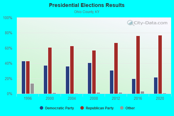
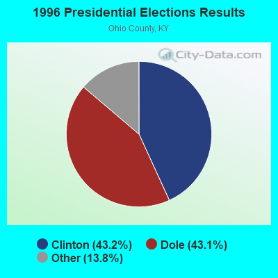
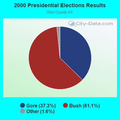
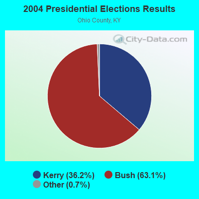
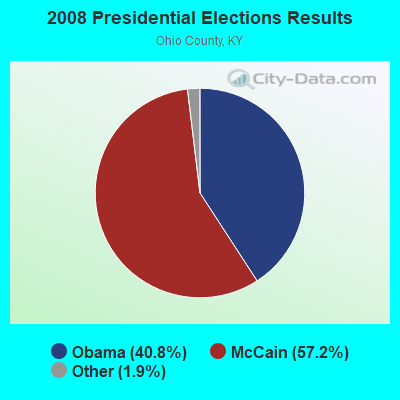
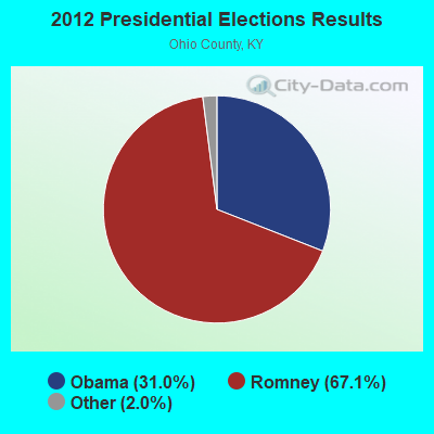
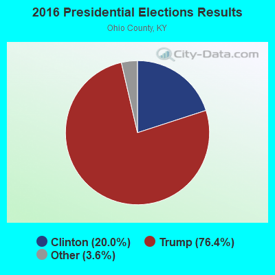
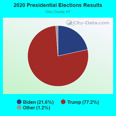
Graphs represent county-level data. Detailed 2008 Election Results
Religion statistics for Centertown, KY (based on Ohio County data)
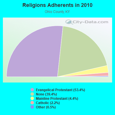
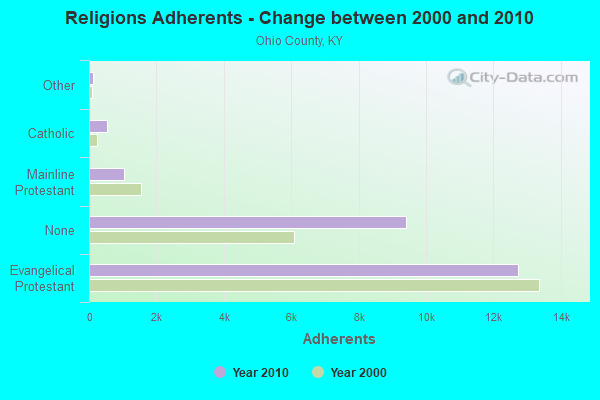
| Religion | Adherents | Congregations |
|---|---|---|
| Evangelical Protestant | 12,741 | 65 |
| Mainline Protestant | 1,042 | 15 |
| Catholic | 530 | 2 |
| Other | 125 | 2 |
| None | 9,404 | - |
Food Environment Statistics:
| Ohio County: | 1.27 / 10,000 pop. |
| State: | 2.19 / 10,000 pop. |
| Ohio County: | 0.42 / 10,000 pop. |
| Kentucky: | 0.25 / 10,000 pop. |
| Ohio County: | 2.97 / 10,000 pop. |
| Kentucky: | 4.36 / 10,000 pop. |
| Ohio County: | 5.10 / 10,000 pop. |
| State: | 5.74 / 10,000 pop. |
| Here: | 13.1% |
| State: | 11.0% |
| This county: | 31.5% |
| Kentucky: | 30.0% |
| Ohio County: | 15.8% |
| Kentucky: | 15.9% |
Health and Nutrition:
| This city: | 43.7% |
| Kentucky: | 49.9% |
| This city: | 41.2% |
| Kentucky: | 47.0% |
| This city: | 29.0 |
| Kentucky: | 28.6 |
| This city: | 18.7% |
| Kentucky: | 21.0% |
| Centertown: | 11.8% |
| Kentucky: | 10.1% |
| Centertown: | 6.8 |
| Kentucky: | 6.8 |
| This city: | 31.6% |
| Kentucky: | 33.8% |
| This city: | 52.1% |
| Kentucky: | 56.8% |
| Centertown: | 81.7% |
| Kentucky: | 78.9% |
More about Health and Nutrition of Centertown, KY Residents
| Local government employment and payroll (March 2022) | |||||
| Function | Full-time employees | Monthly full-time payroll | Average yearly full-time wage | Part-time employees | Monthly part-time payroll |
|---|---|---|---|---|---|
| Other Government Administration | 4 | $12,856 | $38,568 | 10 | $5,837 |
| Other and Unallocable | 2 | $7,577 | $45,462 | 0 | $0 |
| Water Supply | 2 | $7,577 | $45,462 | 0 | $0 |
| Police Protection - Officers | 2 | $7,387 | $44,322 | 0 | $0 |
| Totals for Government | 10 | $35,398 | $42,478 | 10 | $5,837 |
Centertown government finances - Expenditure in 2017 (per resident):
- Current Operations - Water Utilities: $286,000 ($697.56)
Central Staff Services: $270,000 ($658.54)
Sewerage: $122,000 ($297.56)
Police Protection: $42,000 ($102.44)
Local Fire Protection: $32,000 ($78.05)
Regular Highways: $20,000 ($48.78)
- General - Interest on Debt: $16,000 ($39.02)
- Total Salaries and Wages: $241,000 ($587.80)
- Water Utilities - Interest on Debt: $46,000 ($112.20)
Centertown government finances - Revenue in 2017 (per resident):
- Charges - Sewerage: $94,000 ($229.27)
Other: $15,000 ($36.59)
- Local Intergovernmental - Sewerage: $69,000 ($168.29)
- Miscellaneous - Sale of Property: $5,000 ($12.20)
- Revenue - Water Utilities: $379,000 ($924.39)
- State Intergovernmental - Other: $25,000 ($60.98)
Highways: $8,000 ($19.51)
- Tax - Insurance Premiums Sales: $25,000 ($60.98)
Property: $16,000 ($39.02)
Public Utilities Sales: $16,000 ($39.02)
Centertown government finances - Debt in 2017 (per resident):
- Long Term Debt - Beginning Outstanding - Unspecified Public Purpose: $1,536,000 ($3746.34)
Outstanding Unspecified Public Purpose: $1,459,000 ($3558.54)
Retired Unspecified Public Purpose: $77,000 ($187.80)
Centertown government finances - Cash and Securities in 2017 (per resident):
- Other Funds - Cash and Securities: $651,000 ($1587.80)
Strongest AM radio stations in Centertown:
- WAIA (1600 AM; 1 kW; BEAVER DAM, KY; Owner: STARLIGHT BROADCASTING CO., INC.)
- WSM (650 AM; 50 kW; NASHVILLE, TN; Owner: GAYLORD ENTERTAINMENT COMPANY)
- WKDA (1200 AM; 50 kW; NASHVILLE, TN; Owner: RADIO NASHVILLE, INC.)
- WNES (1050 AM; 1 kW; CENTRAL CITY, KY; Owner: STARLIGHT BROADCASTING CO., INC.)
- WAMB (1160 AM; 50 kW; DONELSON, TN; Owner: GREAT SOUTHERN BROADCASTING COMPANY, INC.)
- WNQM (1300 AM; 50 kW; NASHVILLE, TN; Owner: WNQM. INC.)
- WHAS (840 AM; 50 kW; LOUISVILLE, KY; Owner: CLEAR CHANNEL BROADCASTING LICENSES, INC.)
- WLAC (1510 AM; 50 kW; NASHVILLE, TN; Owner: CAPSTAR TX LIMITED PARTNERSHIP)
- WVJS (1420 AM; 5 kW; OWENSBORO, KY; Owner: TSB III, LLC)
- WKCT (930 AM; 5 kW; BOWLING GREEN, KY; Owner: DAILY NEWS BROADCASTING CO.)
- WMTA (1380 AM; 0 kW; CENTRAL CITY, KY; Owner: WMTA, AM 1380,INC.)
- WWAM (820 AM; daytime; 50 kW; JASPER, TN; Owner: SHELTON BROADCASTING SYSTEM)
- WLW (700 AM; 50 kW; CINCINNATI, OH; Owner: JACOR BROADCASTING CORPORATION)
Strongest FM radio stations in Centertown:
- WBKR (92.5 FM; OWENSBORO, KY; Owner: REGENT BROADCASTING OF EVANSVILLE/OWENSBORO, INC.)
- WXMZ (106.3 FM; HARTFORD, KY; Owner: STARLIGHT BROADCASTING CO., INC.)
- WQXQ (101.9 FM; CENTRAL CITY, KY; Owner: STARLIGHT BROADCASTING CO., INC.)
- WSTO (96.1 FM; OWENSBORO, KY; Owner: TSB III, LLC)
- W278AD (103.5 FM; CENTRAL CITY, KY; Owner: HEARTLAND MINISTRIES, INC.)
- WXCM (97.1 FM; HAWESVILLE, KY; Owner: WLME, INC.)
- WUBT (101.1 FM; RUSSELLVILLE, KY; Owner: CAPSTAR TX LIMITED PARTNERSHIP)
- WVVR (100.3 FM; HOPKINSVILLE, KY; Owner: SAGA COMMUNICATIONS OF TUCKESSEE, LLC)
- WKTG (93.9 FM; MADISONVILLE, KY; Owner: SOUND BROADCASTERS, INC.)
- WNTC (103.9 FM; DRAKESBORO, KY; Owner: NASHVILLE'S SPORTSRADIO, INCORPORATED)
- WYMV (106.9 FM; MADISONVILLE, KY; Owner: MADISONVILLE CBC, INC.)
- WBIO (94.7 FM; PHILPOT, KY; Owner: THE CROMWELL GROUP, INC OF KENTUCKY)
- WKDQ (99.5 FM; HENDERSON, KY; Owner: REGENT BROADCASTING OF EVANSVILLE/OWENSBORO, INC.)
- WTCJ-FM (105.7 FM; TELL CITY, IN; Owner: HANCOCK COMMUNICATIONS, INC.)
- WKYA (105.5 FM; GREENVILLE, KY; Owner: STARLIGHT BROADCASTING CO., INC.)
TV broadcast stations around Centertown:
- WKMA-TV (Channel 35; MADISONVILLE, KY; Owner: KENTUCKY AUTHORITY FOR EDUCATIONAL TV)
- W62CJ (Channel 62; JACKSON, TN; Owner: MS COMMUNICATIONS, LLC)
- WNIN (Channel 9; EVANSVILLE, IN; Owner: TRI-STATE PUBLIC TELEPLEX, INC.)
- WAZE-TV (Channel 19; MADISONVILLE, KY; Owner: SOUTH CENTRAL COMMUNICATIONS CORP.)
- WKGB-TV (Channel 53; BOWLING GREEN, KY; Owner: KENTUCKY AUTHORITY FOR EDUCATIONAL TV)
Centertown fatal accident list:
- National Bridge Inventory (NBI) Statistics
- 6Number of bridges
- 23ft / 7.3mTotal length
- 7,223Total average daily traffic
- 1,712Total average daily truck traffic
- 8,333Total future (year 2026) average daily traffic
FCC Registered Antenna Towers:
5- John Pulliam, Approx. 1 Mile Sw Of Centertown (Lat: 37.403056 Lon: -87.007111), Type: 70.1, Structure height: 21183 m, Overall height: 67.1 m, Registrant: Keller And Heckman LLP, Telecomlicensing@khlaw.Com, , Washi-ngton, Phone: (202) 434-4100
- Roy D Gray, Approx. 1 Mile Sw Of Centertown (Lat: 37.403056 Lon: -87.007111), Type: 70.1, Structure height: 21183 m, Overall height: 70.1 m, Registrant: Keller And Heckman LLP, Telecomlicensing@khlaw.Com, , Washi-ngton, Phone: (202) 434-4100
- Roy D Gray, Approx. 1 Mile Sw Of Centertown (Lat: 37.403056 Lon: -87.007111), Type: 70.1, Structure height: 21183 m, Overall height: 70.1 m, Registrant: Keller And Heckman LLP, Telecomlicensing@khlaw.Com, , Washi-ngton, Phone: (202) 434-4100
- John Pulliam, Approx. 1 Mile Sw Of Centertown (Lat: 37.403056 Lon: -87.007111), Type: 70.1, Structure height: 21183 m, Overall height: 70.1 m, Registrant: Keller And Heckman LLP, Telecomlicensing@khlaw.Com, , Washi-ngton, Phone: (202) 434-4100
- John Pulliam, Approx. 1 Mile Sw Of Centertown (Lat: 37.403056 Lon: -87.007111), Type: 70.1, Structure height: 21183 m, Overall height: 70.1 m, Registrant: Keller And Heckman LLP, Telecomlicensing@khlaw.Com, , Washi-ngton, Phone: (202) 434-4100
FCC Registered Broadcast Land Mobile Towers:
5- Lat: 37.409444 Lon: -86.992222, Call Sign: WPSP217,
Assigned Frequencies: 451.950 MHz, 456.950 MHz, Grant Date: 06/29/2001, Expiration Date: 06/29/2011, Cancellation Date: 09/03/2011, Certifier: Michael P Stenberg, Registrant: Troxell, Lorry A, 1588 Fairfield Road, Gettysburg, PA 17325, Phone: (717) 334-9262, Fax: (717) 334-6440
- Hwy 69/Wallace Loop (Lat: 37.416806 Lon: -87.015056), Type: Tank, Structure height: 30.4 m, Call Sign: WPXF946,
Assigned Frequencies: 173.362 MHz, Grant Date: 01/24/2023, Expiration Date: 03/26/2033, Certifier: John Leach, Registrant: Federal Licensing Inc, 1588 Fairfield Road, Gettysburg, PA 17325, Phone: (717) 334-9262, Fax: (717) 334-6440, Email:
- Lat: 37.417444 Lon: -87.000167, Call Sign: WQLC483,
Assigned Frequencies: 156.135 MHz, Grant Date: 10/12/2019, Expiration Date: 12/02/2029, Certifier: Patty S Kessinger, Registrant: Business Radio Licensing, 30251 Golden Lantern, Suite E # 501, Laguna Niguel, CA 92677, Phone: (949) 348-8510, Fax: (949) 348-8514, Email:
- DB WILSON PLANT, Lat: 37.450833 Lon: -87.087778, Call Sign: WQPT463,
Assigned Frequencies: 74.6100 MHz, 75.3900 MHz, Grant Date: 07/12/2022, Expiration Date: 08/10/2032, Certifier: Randall E Hooper, Registrant: Utility Telecom Consulting Group, Inc., 9850 S Maryland Pkwy Ste A5-108, Las Vegas, NV 89183, Phone: (702) 340-1706, Email:
- Lat: 37.404972 Lon: -87.016722, Call Sign: WRWS419,
Assigned Frequencies: 461.993 MHz, 466.993 MHz, Grant Date: 03/22/2023, Expiration Date: 03/22/2033, Certifier: Charlie Montelongo, Registrant: Master Meter Inc., 101 Regency Parkway, Mansfield, TX 76063-5093, Phone: (817) 842-8000, Fax: (817) 842-8030, Email:
FCC Registered Microwave Towers:
6- Centertown Sub, 1/2 Mile East Of Centertown (Lat: 37.416167 Lon: -87.000000), Type: Tower, Structure height: 55.4 m, Call Sign: WPON899,
Assigned Frequencies: 957.950 MHz, Grant Date: 02/10/2010, Expiration Date: 04/26/2020, Cancellation Date: 07/31/2012, Certifier: John E Newland Pe, Registrant: Keller And Heckman LLP, 1001 G Street Nw Suite 500 West, Washington, DC 20001, Phone: (202) 434-4130, Fax: (202) 434-4646
- Equality Mine, 4.5 Miles North Of (Lat: 37.356667 Lon: -87.098889), Type: Pole, Structure height: 18.3 m, Call Sign: WQKP633,
Assigned Frequencies: 957.550 MHz, Grant Date: 05/29/2019, Expiration Date: 08/04/2029, Certifier: Randall E Hooper, Registrant: Utility Telecom Consulting Group, Inc., 9850 S Maryland Pkwy Ste A5-108, Las Vegas, NV 89183, Phone: (702) 340-1706, Email:
- Armstrong Dock, 5.5 Miles West Of (Lat: 37.415583 Lon: -87.094306), Type: Pole, Structure height: 16.8 m, Overall height: 18.3 m, Call Sign: WQKP634,
Assigned Frequencies: 958.750 MHz, Grant Date: 05/29/2019, Expiration Date: 08/04/2029, Certifier: Randall E Hooper, Registrant: Utility Telecom Consulting Group, Inc., 9850 S Maryland Pkwy Ste A5-108, Las Vegas, NV 89183, Phone: (702) 340-1706, Email:
- CENTERTOWN S, Hw 86.7 Mi East Of (Lat: 37.414278 Lon: -86.999167), Type: Tower, Structure height: 54.9 m, Call Sign: WQPG972, Licensee ID: L00197208,
Assigned Frequencies: 11545.0 MHz, 11545.0 MHz, 11545.0 MHz, 11545.0 MHz, Grant Date: 05/15/2012, Expiration Date: 05/15/2022, Cancellation Date: 08/29/2016, Certifier: John E Newland, Registrant: Kenergy Corporation, 6402 Old Corydon Road, Henderson, KY 42419, Phone: (270) 826-3991, Fax: (270) 826-3999, Email:
- Matanzas, Approx. 1 Mile Sw Of Centertown (Lat: 37.403056 Lon: -87.007111), Type: Ltower, Structure height: 70.1 m, Call Sign: WQRD366,
Assigned Frequencies: 5945.20 MHz, 5974.85 MHz, 6034.15 MHz, 6063.80 MHz, 6004.50 MHz, 6093.45 MHz, Grant Date: 01/28/2023, Expiration Date: 04/19/2033, Certifier: John Pulliam, Registrant: Keller And Heckman LLP, 1001 G Street Nw, Suite 500 West, Washington, DC 20001, Phone: (202) 434-4100, Fax: (202) 434-4646, Email:
- CENTERTOWN, 47 Pitts Lane (Lat: 37.414194 Lon: -86.984861), Type: Ltower, Structure height: 54.9 m, Call Sign: WQXU378,
Assigned Frequencies: 10815.0 MHz, 10815.0 MHz, 10815.0 MHz, 10815.0 MHz, 10815.0 MHz, 10815.0 MHz, 10815.0 MHz, 10815.0 MHz, 11545.0 MHz, 11545.0 MHz, 11545.0 MHz, 11545.0 MHz, Grant Date: 06/10/2016, Expiration Date: 06/10/2026, Certifier: Scott Gentry, Registrant: Kenergy Corporation, 6402 Old Corydon Road, Henderson, KY 42419, Phone: (800) 844-4832, Fax: (270) 826-3999, Email:
FCC Registered Amateur Radio Licenses:
4- Call Sign: KA4AJK, Licensee ID: L00853862, Grant Date: 05/23/2014, Expiration Date: 07/14/2024, Certifier: Randall C Render, Registrant: Randall C Render, 429 Gum St, Centertown, KY 42328
- Call Sign: KD4UAU, Licensee ID: L00931690, Grant Date: 08/26/2014, Expiration Date: 10/23/2024, Registrant: James C Reid, 12 Church Street, Centertown, KY 42328
- Call Sign: KF4INT, Grant Date: 04/10/1996, Expiration Date: 04/10/2006, Cancellation Date: 04/11/2008, Registrant: Jeremy L Render, Rt 1 Box 348, Centertown, KY 42328
- Call Sign: WB4TFQ, Licensee ID: L01322121, Grant Date: 11/06/2017, Expiration Date: 12/08/2027, Certifier: Douglas G Smith, Registrant: Douglas G Smith, 413 S Church St, Centertown, KY 42328
| Most common first names in Centertown, KY among deceased individuals | ||
| Name | Count | Lived (average) |
|---|---|---|
| William | 18 | 75.0 years |
| James | 13 | 72.9 years |
| John | 12 | 78.4 years |
| Mary | 9 | 80.3 years |
| Anna | 7 | 81.0 years |
| Robert | 7 | 77.7 years |
| Henry | 5 | 78.0 years |
| Charles | 5 | 66.8 years |
| Walter | 5 | 71.6 years |
| Jessie | 4 | 73.5 years |
| Most common last names in Centertown, KY among deceased individuals | ||
| Last name | Count | Lived (average) |
|---|---|---|
| Brown | 21 | 83.3 years |
| Tichenor | 14 | 83.6 years |
| Ashby | 12 | 81.2 years |
| James | 11 | 76.3 years |
| Smith | 10 | 76.3 years |
| Rowe | 9 | 80.5 years |
| Heflin | 9 | 83.2 years |
| Porter | 9 | 82.8 years |
| Boyd | 8 | 76.2 years |
| Daugherty | 8 | 76.4 years |

- 77.4%Electricity
- 18.3%Bottled, tank, or LP gas
- 2.6%Wood
- 1.7%Utility gas

- 68.3%Electricity
- 29.3%Bottled, tank, or LP gas
- 2.4%Other fuel
Centertown compared to Kentucky state average:
- Median house value below state average.
- Unemployed percentage below state average.
- Black race population percentage significantly below state average.
- Hispanic race population percentage significantly below state average.
- Median age below state average.
- Foreign-born population percentage significantly below state average.
- Renting percentage below state average.
- Length of stay since moving in significantly above state average.
- Number of college students below state average.
- Percentage of population with a bachelor's degree or higher significantly below state average.