Center Point, Tennessee
Submit your own pictures of this place and show them to the world
- OSM Map
- General Map
- Google Map
- MSN Map

| Males: 1,837 | |
| Females: 1,830 |
| Median resident age: | 37.7 years |
| Tennessee median age: | 35.9 years |
Zip code: 37327
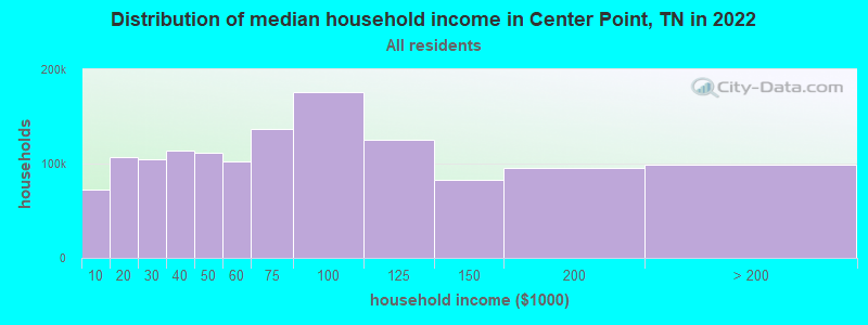
| Center Point: | $59,273 |
| TN: | $65,254 |
Estimated per capita income in 2022: $29,098 (it was $18,129 in 2000)
Center Point CCD income, earnings, and wages data
Estimated median house or condo value in 2022: $238,325 (it was $78,700 in 2000)
| Center Point: | $238,325 |
| TN: | $284,800 |
Detailed information about poverty and poor residents in Center Point, TN


- 3,03397.4%White alone
- 361.2%Hispanic
- 190.6%Two or more races
- 140.4%American Indian alone
- 50.2%Black alone
- 30.10%Other race alone
- 20.06%Asian alone
- 10.03%Native Hawaiian and Other
Pacific Islander alone

Races in Center Point detailed stats: ancestries, foreign born residents, place of birth
 Recent articles from our blog. Our writers, many of them Ph.D. graduates or candidates, create easy-to-read articles on a wide variety of topics.
Current Local Time: CST time zone
Land area: 104.1 square miles.
Population density: 35 people per square mile (very low).

| Center Point CCD: | 0.5% ($401) |
| Tennessee: | 0.8% ($715) |
Nearest city with pop. 50,000+: Chattanooga, TN  (18.9 miles , pop. 155,554).
Nearest city with pop. 200,000+: Nashville-Davidson, TN (98.5 miles , pop. 545,524).
Nearest city with pop. 1,000,000+: Chicago, IL (468.8 miles , pop. 2,896,016).
Nearest cities:
), ), ), ), ), )Latitude: 35.31 N, Longitude: 85.35 W
Area code commonly used in this area: 423

| Here: | 3.5% |
| Tennessee: | 3.0% |
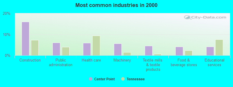
- Construction (15.9%)
- Public administration (6.1%)
- Health care (6.0%)
- Machinery (5.6%)
- Textile mills & textile products (4.5%)
- Food & beverage stores (4.2%)
- Educational services (4.2%)
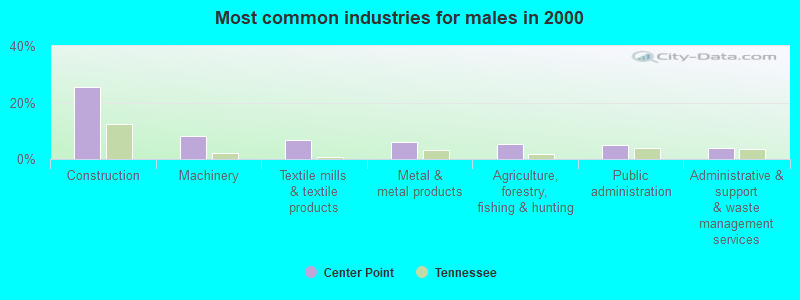
- Construction (25.6%)
- Machinery (8.1%)
- Textile mills & textile products (6.8%)
- Metal & metal products (5.9%)
- Agriculture, forestry, fishing & hunting (5.2%)
- Public administration (5.1%)
- Administrative & support & waste management services (4.0%)
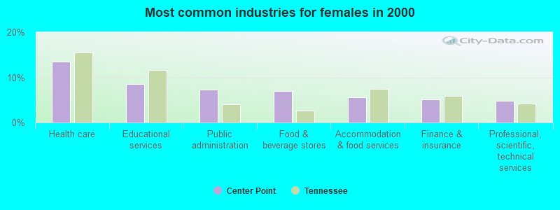
- Health care (13.5%)
- Educational services (8.5%)
- Public administration (7.3%)
- Food & beverage stores (7.0%)
- Accommodation & food services (5.6%)
- Finance & insurance (5.2%)
- Professional, scientific, technical services (4.9%)

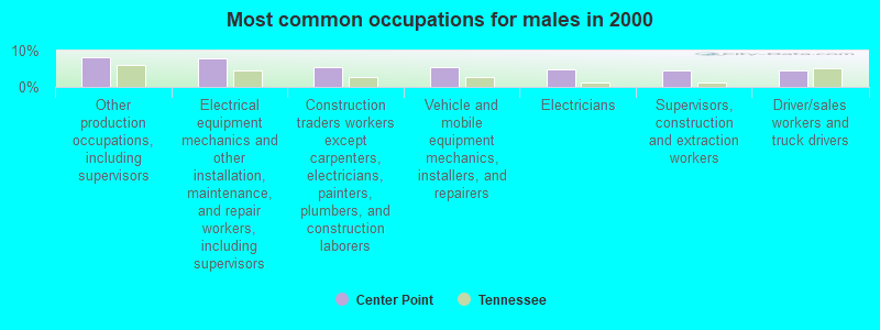
- Other production occupations, including supervisors (7.2%)
- Cashiers (4.5%)
- Electrical equipment mechanics and other installation, maintenance, and repair workers, including supervisors (4.4%)
- Electricians (4.1%)
- Textile, apparel, and furnishings workers (3.8%)
- Assemblers and fabricators (3.2%)
- Building and grounds cleaning and maintenance occupations (3.2%)
- Other production occupations, including supervisors (8.3%)
- Electrical equipment mechanics and other installation, maintenance, and repair workers, including supervisors (7.9%)
- Construction traders workers except carpenters, electricians, painters, plumbers, and construction laborers (5.6%)
- Vehicle and mobile equipment mechanics, installers, and repairers (5.4%)
- Electricians (4.8%)
- Supervisors, construction and extraction workers (4.6%)
- Driver/sales workers and truck drivers (4.5%)
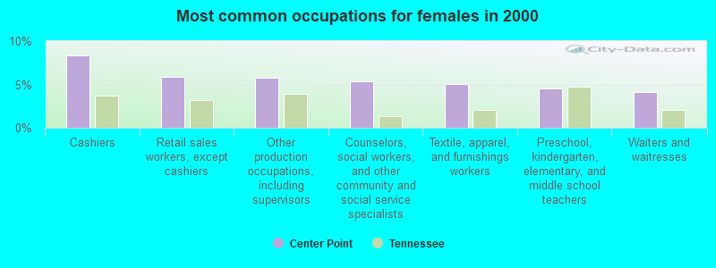
- Cashiers (8.3%)
- Retail sales workers, except cashiers (5.9%)
- Other production occupations, including supervisors (5.8%)
- Counselors, social workers, and other community and social service specialists (5.3%)
- Textile, apparel, and furnishings workers (5.0%)
- Preschool, kindergarten, elementary, and middle school teachers (4.6%)
- Waiters and waitresses (4.1%)
Average climate in Center Point, Tennessee
Based on data reported by over 4,000 weather stations


(lower is better)
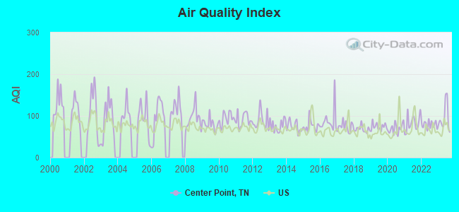
Air Quality Index (AQI) level in 2023 was 94.7. This is worse than average.
| City: | 94.7 |
| U.S.: | 72.6 |
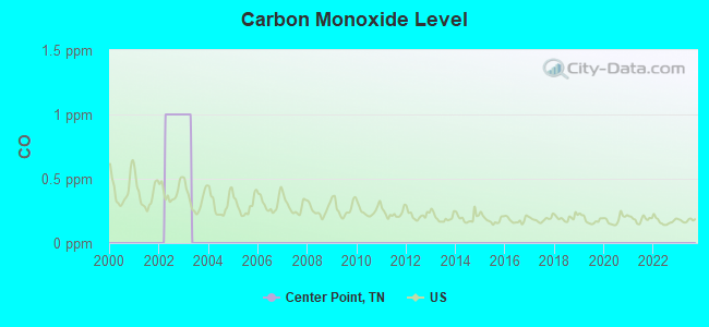
Carbon Monoxide (CO) [ppm] level in 2002 was 1.00. This is significantly worse than average. Closest monitor was 21.5 miles away from the city center.
| City: | 1.00 |
| U.S.: | 0.25 |
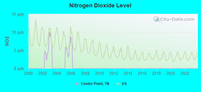
Nitrogen Dioxide (NO2) [ppb] level in 2005 was 5.46. This is about average. Closest monitor was 13.2 miles away from the city center.
| City: | 5.46 |
| U.S.: | 5.11 |
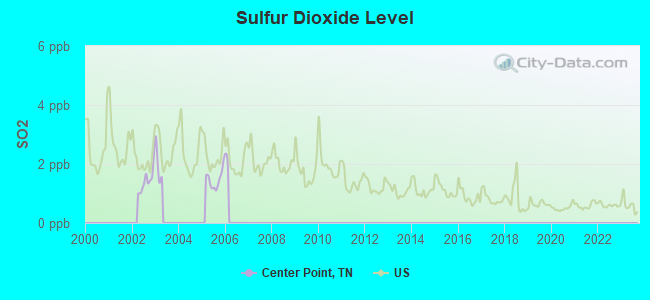
Sulfur Dioxide (SO2) [ppb] level in 2005 was 1.48. This is about average. Closest monitor was 13.8 miles away from the city center.
| City: | 1.48 |
| U.S.: | 1.51 |
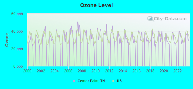
Ozone [ppb] level in 2023 was 34.7. This is about average. Closest monitor was 10.8 miles away from the city center.
| City: | 34.7 |
| U.S.: | 33.3 |
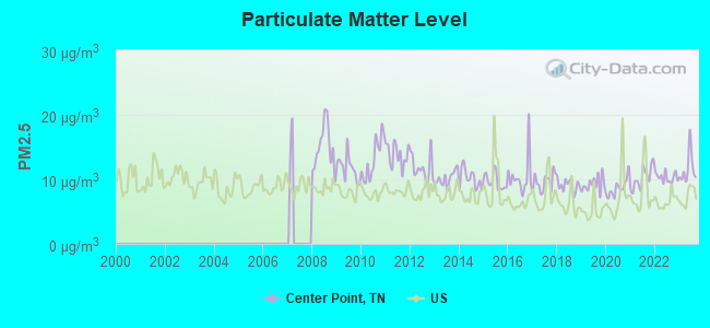
Particulate Matter (PM2.5) [µg/m3] level in 2023 was 11.6. This is significantly worse than average. Closest monitor was 10.8 miles away from the city center.
| City: | 11.6 |
| U.S.: | 8.1 |
Tornado activity:
Center Point-area historical tornado activity is near Tennessee state average. It is 41% greater than the overall U.S. average.
On 4/3/1974, a category F5 (max. wind speeds 261-318 mph) tornado 39.0 miles away from the Center Point place center killed 16 people and injured 190 people.
On 5/2/1953, a category F4 (max. wind speeds 207-260 mph) tornado 35.1 miles away from the place center killed 4 people and injured 8 people and caused between $50,000 and $500,000 in damages.
Earthquake activity:
Center Point-area historical earthquake activity is significantly above Tennessee state average. It is 122% greater than the overall U.S. average.On 4/29/2003 at 08:59:39, a magnitude 4.9 (4.4 MB, 4.6 MW, 4.9 LG, Class: Light, Intensity: IV - V) earthquake occurred 58.7 miles away from Center Point center
On 4/29/2003 at 08:59:39, a magnitude 4.6 (4.6 MW, Depth: 12.3 mi) earthquake occurred 58.7 miles away from Center Point center
On 11/30/1973 at 07:48:41, a magnitude 4.7 (4.7 MB, 4.6 ML) earthquake occurred 85.0 miles away from Center Point center
On 12/12/2018 at 09:14:43, a magnitude 4.4 (4.4 MW, Depth: 4.9 mi) earthquake occurred 40.5 miles away from the city center
On 7/27/1980 at 18:52:21, a magnitude 5.2 (5.1 MB, 4.7 MS, 5.0 UK, 5.2 UK, Class: Moderate, Intensity: VI - VII) earthquake occurred 214.8 miles away from the city center
On 4/18/2008 at 09:36:59, a magnitude 5.4 (5.1 MB, 4.8 MS, 5.4 MW, 5.2 MW) earthquake occurred 258.6 miles away from Center Point center
Magnitude types: regional Lg-wave magnitude (LG), body-wave magnitude (MB), local magnitude (ML), surface-wave magnitude (MS), moment magnitude (MW)
Natural disasters:
The number of natural disasters in Sequatchie County (16) is near the US average (15).Major Disasters (Presidential) Declared: 10
Emergencies Declared: 2
Causes of natural disasters: Floods: 8, Storms: 8, Tornadoes: 5, Winter Storms: 3, Fires: 2, Winds: 2, Flash Flood: 1, Heavy Rain: 1, Hurricane: 1, Ice Storm: 1, Landslide: 1, Mudslide: 1, Snowfall: 1, Other: 1 (Note: some incidents may be assigned to more than one category).
Hospitals and medical centers near Center Point:
- NHC HEALTHCARE, SEQUATCHIE (Nursing Home, about 6 miles away; DUNLAP, TN)
- ORANGE GROVE CENTER/PINE MARR (Hospital, about 12 miles away; HIXSON, TN)
- SODDY-DAISY HEALTH CARE CENTER (Nursing Home, about 12 miles away; SODDY-DAISY, TN)
- (CLOSED) COLUMBIA WHITWELL MEDICAL CENTER INC (Hospital, about 13 miles away; WHITWELL, TN)
- ORANGE GROVE CENTER SHELBY (Hospital, about 13 miles away; HIXSON, TN)
- CHATTANOOGA KIDNEY CENTER NORTH, LLC (Dialysis Facility, about 14 miles away; CHATTANOOGA, TN)
- RIVERCHASE HOSPITAL (Hospital, about 14 miles away; CHATTANOOGA, TN)
Operable nuclear power plants near Center Point:
- 11 miles: Sequoyah 1 and 2 in Soddy-Daisy, TN.
Colleges/universities with over 2000 students nearest to Center Point:
- Chattanooga State Community College (about 16 miles; Chattanooga, TN; Full-time enrollment: 6,827)
- The University of Tennessee-Chattanooga (about 19 miles; Chattanooga, TN; FT enrollment: 10,158)
- Southern Adventist University (about 25 miles; Collegedale, TN; FT enrollment: 2,898)
- Cleveland State Community College (about 28 miles; Cleveland, TN; FT enrollment: 2,500)
- Lee University (about 29 miles; Cleveland, TN; FT enrollment: 4,422)
- Dalton State College (about 42 miles; Dalton, GA; FT enrollment: 3,846)
- Motlow State Community College (about 54 miles; Tullahoma, TN; FT enrollment: 2,915)
Points of interest:
Notable locations in Center Point: Lewis Chapel (A), Stewart Camp (B), Double Bridges (C), Lewis Chapel Volunteer Fire Department (D). Display/hide their locations on the map
Churches in Center Point include: Lewis Chapel (A), Taft Highway Church (B), Davis Chapel (C), Hall Church (D), Sequatchie Chapel (E), Welch Chapel (F), Hopewell Church (G), Chapel Hill Church (H), New Hope Church (I). Display/hide their locations on the map
Cemeteries: Hudson Cemetery (1), Lewis Cemetery (2), Chapel Hill Cemetery (3), Welch Chapel Cemetery (4), McWilliams Cemetery (5), Hall Cemetery (6), Harvey Cemetery (7). Display/hide their locations on the map
Reservoirs: Glen Barker Lake (A), Ernest Taylor Lake (B). Display/hide their locations on the map
Streams, rivers, and creeks: Lewis Creek (A), Kell Branch (B), Welch Branch (C), Harvey Creek (D), Standifer Creek (E), Emmaline Branch (F), Easterly Branch (G), Dry Branch (H), Cove Branch (I). Display/hide their locations on the map
| This place: | 2.5 people |
| Tennessee: | 2.5 people |
| This place: | 66.2% |
| Whole state: | 69.8% |
| This place: | 5.6% |
| Whole state: | 4.2% |
Likely homosexual households (counted as self-reported same-sex unmarried-partner households)
- Lesbian couples: 0.5% of all households
- Gay men: 0.3% of all households
| This place: | 12.1% |
| Whole state: | 13.5% |
| This place: | 7.1% |
| Whole state: | 5.8% |
For population 15 years and over in Center Point:
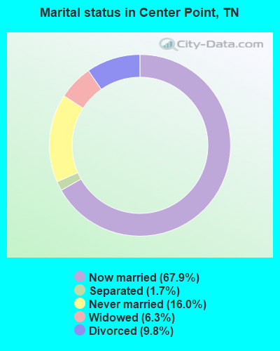
- Never married: 16.0%
- Now married: 67.9%
- Separated: 1.7%
- Widowed: 6.3%
- Divorced: 9.8%
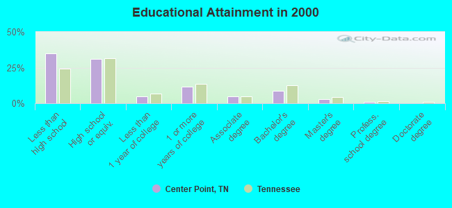
For population 25 years and over in Center Point:
- High school or higher: 65.2%
- Bachelor's degree or higher: 12.8%
- Graduate or professional degree: 4.2%
- Unemployed: 2.5%
- Mean travel time to work (commute): 29.0 minutes
| Here: | 13.2 |
| Tennessee average: | 13.3 |
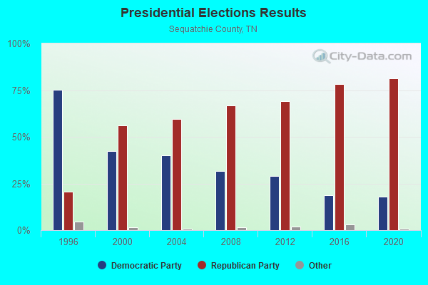
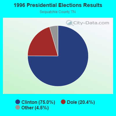
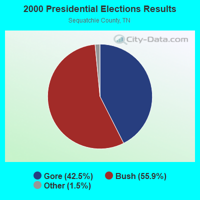
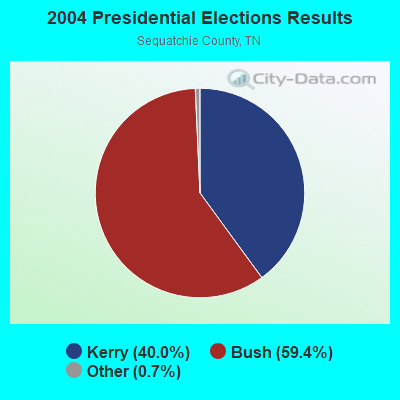
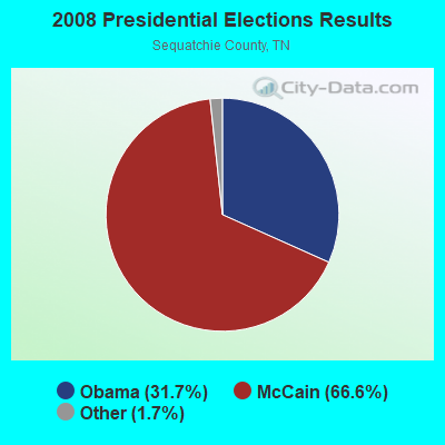

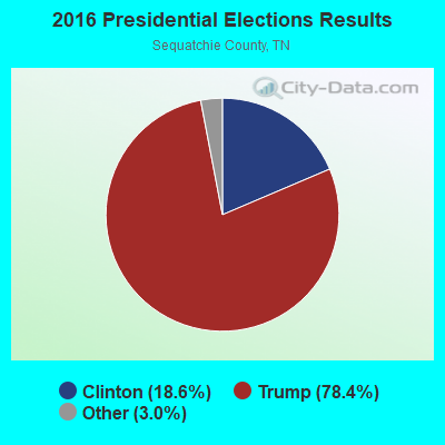
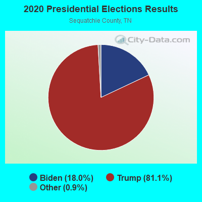
Graphs represent county-level data. Detailed 2008 Election Results
Religion statistics for Center Point, TN (based on Sequatchie County data)
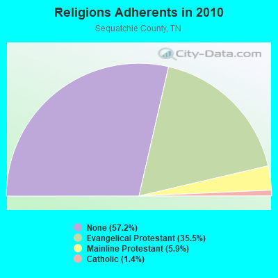
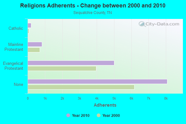
| Religion | Adherents | Congregations |
|---|---|---|
| Evangelical Protestant | 5,007 | 30 |
| Mainline Protestant | 826 | 2 |
| Catholic | 200 | 1 |
| Other | 2 | - |
| None | 8,077 | - |
Food Environment Statistics:
| Sequatchie County: | 0.75 / 10,000 pop. |
| Tennessee: | 1.99 / 10,000 pop. |
| Here: | 6.74 / 10,000 pop. |
| State: | 5.16 / 10,000 pop. |
| Here: | 9.73 / 10,000 pop. |
| Tennessee: | 6.56 / 10,000 pop. |
| Sequatchie County: | 11.0% |
| State: | 11.4% |
| Sequatchie County: | 30.9% |
| Tennessee: | 30.2% |
| This county: | 11.4% |
| Tennessee: | 13.5% |
Strongest AM radio stations in Center Point:
- WSDQ (1190 AM; daytime; 5 kW; DUNLAP, TN; Owner: RODGSON, INC.)
- WFLI (1070 AM; 50 kW; LOOKOUT MOUNTAIN, TN; Owner: WFLI, INC.)
- WWAM (820 AM; daytime; 50 kW; JASPER, TN; Owner: SHELTON BROADCASTING SYSTEM)
- WGOW (1150 AM; 5 kW; CHATTANOOGA, TN; Owner: CITADEL BROADCASTING COMPANY)
- WDOD (1310 AM; 5 kW; CHATTANOOGA, TN; Owner: WDOD OF CHATTANOOGA, INC.)
- WNOO (1260 AM; 5 kW; CHATTANOOGA, TN; Owner: PYE BROADCASTING, INC.)
- WDEF (1370 AM; 5 kW; CHATTANOOGA, TN; Owner: JACKSON TELECASTERS, INC)
- WSM (650 AM; 50 kW; NASHVILLE, TN; Owner: GAYLORD ENTERTAINMENT COMPANY)
- WSDT (1240 AM; 1 kW; SODDY-DAISY, TN; Owner: WILLIS BROADCASTING CORPORATION)
- WEPG (910 AM; 5 kW; SOUTH PITTSBURG, TN; Owner: STONE/COLLINS COMMUNICATIONS, INC.)
- WKVL (850 AM; daytime; 50 kW; KNOXVILLE, TN; Owner: HORNE RADIO, LLC)
- WCNN (680 AM; 50 kW; NORTH ATLANTA, GA; Owner: DICKEY BROADCASTING COMPANY)
- WNSI (810 AM; 50 kW; JACKSONVILLE, AL; Owner: UNITED BROADCASTING NETWORK, INC.)
Strongest FM radio stations in Center Point:
- WUSY (100.7 FM; CLEVELAND, TN; Owner: CAPSTAR TX LIMITED PARTNERSHIP)
- WSMC-FM (90.5 FM; COLLEGEDALE, TN; Owner: SOUTHERN COLLEGE OF SEVENTH-DAY ADVT)
- WUTC (88.1 FM; CHATTANOOGA, TN; Owner: UNIVERSITY OF TENNESSEE)
- W268AA (101.5 FM; FALLING WATER, TN; Owner: S/WEST FLORIDA COMMUNITY RADIO, INC.)
- WDOD-FM (96.5 FM; CHATTANOOGA, TN; Owner: WDOD OF CHATTANOOGA, INC.)
- WSKZ (106.5 FM; CHATTANOOGA, TN; Owner: CITADEL BROADCASTING COMPANY)
- WOGT (107.9 FM; EAST RIDGE, TN; Owner: CITADEL BROADCASTING COMPANY)
- W203AZ (88.5 FM; FAIRMOUNT, TN; Owner: CALVARY CHAPEL OF TWIN FALLS, INC.)
- WDEF-FM (92.3 FM; CHATTANOOGA, TN; Owner: JACKSON TELECASTERS, INC.)
- W211BG (90.1 FM; WALDEN, TN; Owner: EDUCATIONAL MEDIA FOUNDATION)
- WDYN (89.7 FM; CHATTANOOGA, TN; Owner: TENNESSEE TEMPLE UNIVERSITY)
- W278AC (103.5 FM; WALDEN, TN; Owner: CAPSTAR TX LIMITED PARTNERSHIP)
- WMBW (88.9 FM; CHATTANOOGA, TN; Owner: THE MOODY BIBLE INSTITUTE OF CHICAGO)
- W257AZ (99.3 FM; LOOKOUT MOUNTAIN, TN; Owner: CAPSTAR TX LIMITED PARTNERSHIP)
- WKXJ (98.1 FM; SIGNAL MOUNTAIN, TN; Owner: CAPSTAR TX LIMITED PARTNERSHIP)
- WAYB-FM (95.7 FM; GRAYSVILLE, TN; Owner: FAMILY WORSHIP CENTER CHURCH, INC.)
- WBDX (102.7 FM; TRENTON, GA; Owner: PARTNERS FOR CHRISTIAN RADIO, INC.)
- WALV (95.3 FM; CLEVELAND, TN; Owner: J. L. BREWER BROADCASTING OF CLEVELAND, LLC)
- WGOW-FM (102.3 FM; SODDY-DAISY, TN; Owner: CITADEL BROADCASTING COMPANY)
- WDNT-FM (104.9 FM; DAYTON, TN; Owner: J. L. BREWER BROADCASTING OF CLEVELAND, LLC)
TV broadcast stations around Center Point:
- WFLI-TV (Channel 53; CLEVELAND, TN; Owner: CHATTANOOGA MEDIA HOLDINGS, L.L.C.)
- WDSI-TV (Channel 61; CHATTANOOGA, TN; Owner: WDSI LICENSE CORP.)
- WTCI (Channel 45; CHATTANOOGA, TN; Owner: THE GREATER CHATTANOOGA PUBLIC TELEVISION CORP)
- W26BE (Channel 26; CHATTANOOGA, TN; Owner: THREE ANGELS BROADCASTING NETWORK)
- WRCB-TV (Channel 3; CHATTANOOGA, TN; Owner: SARKES TARZIAN, INC.)
- WDEF-TV (Channel 12; CHATTANOOGA, TN; Owner: MEDIA GENERAL COMMUNICATIONS, INC.)
- WOOT-LP (Channel 6; CHATTANOOGA, ETC., TN; Owner: TIGER EYE BROADCASTING CORPORATION)
- WTVC (Channel 9; CHATTANOOGA, TN; Owner: FREEDOM BROADCASTING OF TENNESSEE, INC.)
- WCNT-LP (Channel 65; CHATTANOOGA, TN; Owner: NORTH GEORGIA TELEVISION)
- WYHB-CA (Channel 39; CHATTANOOGA, TN; Owner: YING HUA BENNS)
- WELF (Channel 23; DALTON, GA; Owner: TRINITY BROADCASTING NETWORK)
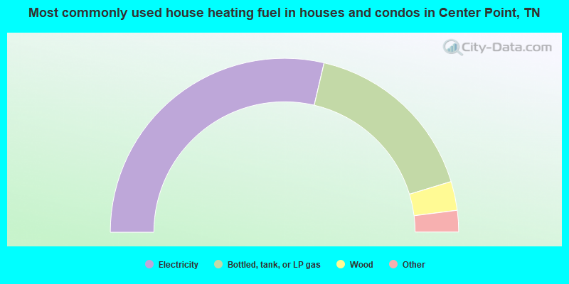
- 57.3%Electricity
- 33.3%Bottled, tank, or LP gas
- 5.4%Wood
- 2.0%Utility gas
- 1.9%Fuel oil, kerosene, etc.

- 58.2%Electricity
- 32.1%Bottled, tank, or LP gas
- 4.9%Fuel oil, kerosene, etc.
- 4.9%Wood
Center Point compared to Tennessee state average:
- Unemployed percentage significantly below state average.
- Black race population percentage significantly below state average.
- Hispanic race population percentage significantly below state average.
- Foreign-born population percentage significantly below state average.
- Renting percentage significantly below state average.
- Length of stay since moving in significantly above state average.
- Number of rooms per house significantly below state average.
- House age significantly below state average.
- Number of college students below state average.
- Percentage of population with a bachelor's degree or higher below state average.