Cedar Grove, Georgia
Submit your own pictures of this place and show them to the world
- OSM Map
- General Map
- Google Map
- MSN Map

| Males: 548 | |
| Females: 523 |
| Median resident age: | 38.3 years |
| Georgia median age: | 33.4 years |
Zip code: 31021
| Cedar Grove: | $55,793 |
| GA: | $72,837 |
Estimated per capita income in 2022: $27,586 (it was $16,539 in 2000)
Cedar Grove CCD income, earnings, and wages data
Estimated median house or condo value in 2022: $132,736 (it was $51,300 in 2000)
| Cedar Grove: | $132,736 |
| GA: | $297,400 |
Detailed information about poverty and poor residents in Cedar Grove, GA


- 86985.6%White alone
- 11511.3%Black alone
- 282.8%Hispanic
- 30.3%American Indian alone

Races in Cedar Grove detailed stats: ancestries, foreign born residents, place of birth
 Recent articles from our blog. Our writers, many of them Ph.D. graduates or candidates, create easy-to-read articles on a wide variety of topics.
Current Local Time: EST time zone
Land area: 119.0 square miles.
Population density: 9.0 people per square mile (very low).

| Cedar Grove CCD: | 0.5% ($272) |
| Georgia: | 0.9% ($919) |
Nearest city with pop. 50,000+: Macon, GA  (60.3 miles , pop. 97,255).
Nearest city with pop. 200,000+: Atlanta, GA (136.6 miles , pop. 416,474).
Nearest city with pop. 1,000,000+: Philadelphia, PA (684.3 miles , pop. 1,517,550).
Nearest cities:
Latitude: 32.29 N, Longitude: 82.83 W
Area code: 478


| Here: | 3.5% |
| Georgia: | 2.9% |

- Public administration (10.5%)
- Health care (10.5%)
- Agriculture, forestry, fishing & hunting (8.1%)
- Educational services (7.4%)
- Furniture & related product manufacturing (7.0%)
- Construction (5.0%)
- Administrative & support & waste management services (4.4%)

- Agriculture, forestry, fishing & hunting (11.3%)
- Public administration (11.0%)
- Construction (8.2%)
- Furniture & related product manufacturing (8.2%)
- Repair & maintenance (7.1%)
- Mining, quarrying, oil & gas extraction (5.7%)
- Miscellaneous manufacturing (3.9%)

- Health care (23.3%)
- Educational services (16.5%)
- Finance & insurance (10.2%)
- Public administration (9.7%)
- Administrative & support & waste management services (8.0%)
- Food & beverage stores (6.2%)
- Accommodation & food services (6.2%)

- Driver/sales workers and truck drivers (8.1%)
- Other office and administrative support workers, including supervisors (7.6%)
- Electrical equipment mechanics and other installation, maintenance, and repair workers, including supervisors (5.9%)
- Cashiers (4.1%)
- Law enforcement workers, including supervisors (3.9%)
- Construction traders workers except carpenters, electricians, painters, plumbers, and construction laborers (3.9%)
- Bookkeeping, accounting, and auditing clerks (3.5%)

- Driver/sales workers and truck drivers (13.1%)
- Electrical equipment mechanics and other installation, maintenance, and repair workers, including supervisors (9.6%)
- Law enforcement workers, including supervisors (6.4%)
- Construction traders workers except carpenters, electricians, painters, plumbers, and construction laborers (6.4%)
- Fishing, hunting, and forestry occupations (5.3%)
- Motor vehicle operators, except bus and truck drivers (5.0%)
- Other management occupations, except farmers and farm managers (4.3%)

- Other office and administrative support workers, including supervisors (14.2%)
- Cashiers (10.8%)
- Bookkeeping, accounting, and auditing clerks (9.1%)
- Preschool, kindergarten, elementary, and middle school teachers (8.0%)
- Nursing, psychiatric, and home health aides (7.4%)
- Financial clerks, except bookkeeping, accounting and auditing clerks (7.4%)
- Other teachers, instructors, education, training, and library occupations (4.5%)
Average climate in Cedar Grove, Georgia
Based on data reported by over 4,000 weather stations


Tornado activity:
Cedar Grove-area historical tornado activity is slightly below Georgia state average. It is 8% greater than the overall U.S. average.
On 5/11/2008, a category F3 (max. wind speeds 158-206 mph) tornado 15.3 miles away from the Cedar Grove place center .
On 4/8/1957, a category F3 tornado 30.1 miles away from the place center killed one person and injured 3 people and caused between $5000 and $50,000 in damages.
Earthquake activity:
Cedar Grove-area historical earthquake activity is significantly above Georgia state average. It is 19% smaller than the overall U.S. average.On 8/2/1974 at 08:52:09, a magnitude 4.9 (4.3 MB, 4.9 LG, Class: Light, Intensity: IV - V) earthquake occurred 111.6 miles away from Cedar Grove center
On 11/22/1974 at 05:25:55, a magnitude 4.7 (4.7 MB) earthquake occurred 162.4 miles away from the city center
On 4/29/2003 at 08:59:39, a magnitude 4.9 (4.4 MB, 4.6 MW, 4.9 LG) earthquake occurred 222.2 miles away from the city center
On 8/21/1992 at 16:31:55, a magnitude 4.4 (4.1 MB, 4.1 LG, 4.4 LG, Depth: 6.2 mi) earthquake occurred 166.9 miles away from Cedar Grove center
On 2/15/2014 at 03:23:38, a magnitude 4.1 (4.1 MW, Depth: 3.2 mi) earthquake occurred 114.3 miles away from the city center
On 8/9/2020 at 12:07:37, a magnitude 5.1 (5.1 MW, Depth: 4.7 mi, Class: Moderate, Intensity: VI - VII) earthquake occurred 306.4 miles away from the city center
Magnitude types: regional Lg-wave magnitude (LG), body-wave magnitude (MB), moment magnitude (MW)
Natural disasters:
The number of natural disasters in Laurens County (11) is smaller than the US average (15).Major Disasters (Presidential) Declared: 6
Emergencies Declared: 4
Causes of natural disasters: Floods: 4, Storms: 3, Hurricanes: 2, Winter Storms: 2, Drought: 1, Snowfall: 1, Tornado: 1, Tropical Storm: 1, Other: 1 (Note: some incidents may be assigned to more than one category).
Colleges/universities with over 2000 students nearest to Cedar Grove:
- East Georgia State College (about 38 miles; Swainsboro, GA; Full-time enrollment: 2,345)
- Central Georgia Technical College (about 52 miles; Warner Robins, GA; FT enrollment: 6,829)
- South Georgia State College (about 55 miles; Douglas, GA; FT enrollment: 2,507)
- Georgia Military College-Distance Learning Campuses (about 60 miles; Milledgeville, GA; FT enrollment: 6,438)
- Georgia College and State University (about 60 miles; Milledgeville, GA; FT enrollment: 6,271)
- Mercer University (about 61 miles; Macon, GA; FT enrollment: 6,297)
- Georgia Southern University (about 63 miles; Statesboro, GA; FT enrollment: 18,824)
Points of interest:
Notable locations in Cedar Grove: Diamond Landing (A), Windham Greenhouses (B), Laurens County Fire Department Station 14 Cedar Grove (C), Laurens County Fire Department Station 16 Lowery (D). Display/hide their locations on the map
Churches in Cedar Grove include: Browning Church (A), Cedar Grove Church (B), McRae Church (C), Oak Dale Church (D), Pearlie Church (E), Saint Marks Church (F), South Poplar Springs Church (G), Union Springs Church (H), White Springs Church (I). Display/hide their locations on the map
Cemeteries: Antioch Cemetery (1), Lowery Cemetery (2), Braceville Cemetery (3), McDaniel Cemetery (4), Burch Cemetery (5), Miller Cemetery (6). Display/hide their locations on the map
Reservoirs: Swinson Lake (A), Currie Lake (B). Display/hide their locations on the map
Streams, rivers, and creeks: Whitewater Creek (A), Flat Creek (B), Buck Creek (C), Pitts Creek (D), Ochwalkee Creek (E), Bay Branch (F), Long Branch (G), Lime Sink Creek (H), Land Branch (I). Display/hide their locations on the map
| This place: | 2.4 people |
| Georgia: | 2.6 people |
| This place: | 70.0% |
| Whole state: | 68.5% |
| This place: | 3.3% |
| Whole state: | 5.9% |
Likely homosexual households (counted as self-reported same-sex unmarried-partner households)
- Lesbian couples: 0.2% of all households
- Gay men: 0.5% of all households
| This place: | 8.5% |
| Whole state: | 13.0% |
| This place: | 3.6% |
| Whole state: | 6.1% |
For population 15 years and over in Cedar Grove:

- Never married: 14.6%
- Now married: 72.1%
- Separated: 2.0%
- Widowed: 8.0%
- Divorced: 5.3%
For population 25 years and over in Cedar Grove:
- High school or higher: 75.8%
- Bachelor's degree or higher: 10.0%
- Graduate or professional degree: 2.4%
- Unemployed: 2.8%
- Mean travel time to work (commute): 44.5 minutes


| Here: | 10.3 |
| Georgia average: | 13.3 |
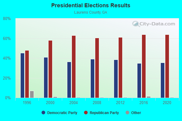
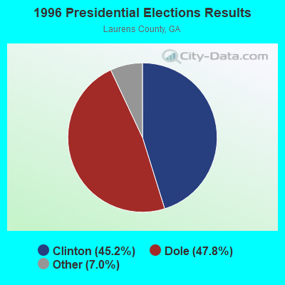
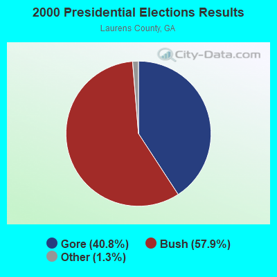

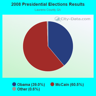
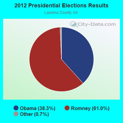

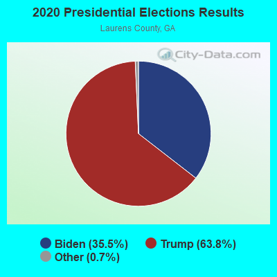
Graphs represent county-level data. Detailed 2008 Election Results
Religion statistics for Cedar Grove, GA (based on Laurens County data)
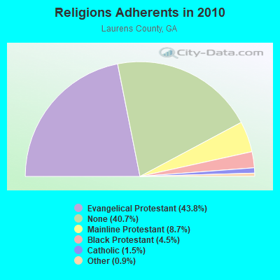
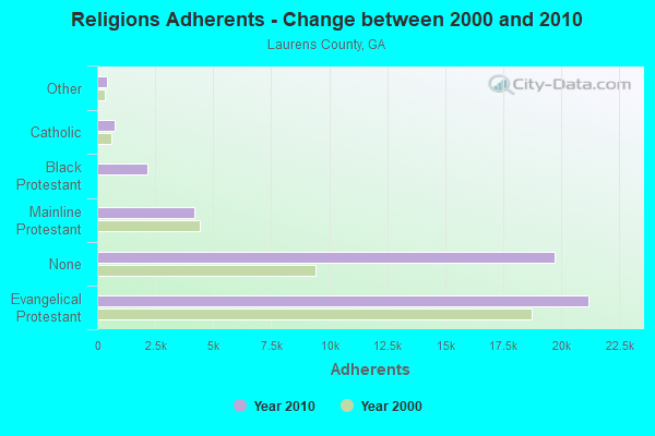
| Religion | Adherents | Congregations |
|---|---|---|
| Evangelical Protestant | 21,192 | 86 |
| Mainline Protestant | 4,205 | 24 |
| Black Protestant | 2,164 | 13 |
| Catholic | 739 | 1 |
| Other | 423 | 2 |
| None | 19,711 | - |
Food Environment Statistics:
| Laurens County: | 1.48 / 10,000 pop. |
| Georgia: | 1.91 / 10,000 pop. |
| Here: | 0.63 / 10,000 pop. |
| Georgia: | 0.86 / 10,000 pop. |
| Laurens County: | 8.44 / 10,000 pop. |
| Georgia: | 5.12 / 10,000 pop. |
| Laurens County: | 6.12 / 10,000 pop. |
| Georgia: | 7.41 / 10,000 pop. |
| Laurens County: | 13.3% |
| Georgia: | 10.4% |
| Here: | 31.2% |
| Georgia: | 27.8% |
| Laurens County: | 17.8% |
| Georgia: | 14.6% |
Strongest AM radio stations in Cedar Grove:
- WMAC (940 AM; 50 kW; MACON, GA; Owner: CUMULUS LICENSING CORP.)
- WMLT (1330 AM; 5 kW; DUBLIN, GA; Owner: STATE BROADCASTING CORPORATION)
- WVOP (970 AM; 5 kW; VIDALIA, GA; Owner: VIDALIA COMMUNICATIONS CORPORATION)
- WUFF (710 AM; daytime; 2 kW; EASTMAN, GA; Owner: FARNELL O'QUINN)
- WNNG (1350 AM; 15 kW; WARNER ROBINS, GA; Owner: CHASE BROADCASTING, INC.)
- WGST (640 AM; 50 kW; ATLANTA, GA; Owner: CITICASTERS LICENSES, L.P.)
- WSB (750 AM; 50 kW; ATLANTA, GA; Owner: CXR HOLDINGS, INC.)
- WCNN (680 AM; 50 kW; NORTH ATLANTA, GA; Owner: DICKEY BROADCASTING COMPANY)
- WOKV (690 AM; 50 kW; JACKSONVILLE, FL; Owner: COX RADIO, INC.)
- WXJO (1120 AM; daytime; 10 kW; GORDON, GA; Owner: ROBERTS COMMUNICATIONS, INC.)
- WGUN (1010 AM; 50 kW; ATLANTA, GA; Owner: WGUN, INC.)
- WYIS (1410 AM; 1 kW; MCRAE, GA; Owner: CINECOM BROASCASTING SYSTEM, INC.)
- WFVR (910 AM; 50 kW; VALDOSTA, GA; Owner: RAMA COMMUNICATIONS, INC.)
Strongest FM radio stations in Cedar Grove:
- WMCG (104.9 FM; MILAN, GA; Owner: TEL-DODGE BROADCASTING CO.)
- WKTM (106.1 FM; SOPERTON, GA; Owner: BARINOWSKI INVESTMENT COMPANY)
- WDCO-FM (89.7 FM; COCHRAN, GA; Owner: GEORGIA PUBLIC TELECOMMUNICATIONS COMMISSION)
- WQZY (95.9 FM; DUBLIN, GA; Owner: STATE BROADCASTING CORPORATION)
- WKKZ (92.7 FM; DUBLIN, GA; Owner: KIRBY BROADCASTING COMPANY)
- WELT (98.1 FM; SWAINSBORO, GA; Owner: LACOM COMMUNICATIONS, INC.)
- WYSC (102.7 FM; MCRAE, GA; Owner: CINECOM BROASCASTING SYSTEM, INC.)
- WGPH (91.5 FM; VIDALIA, GA; Owner: AUGUSTA RADIO FELLOWSHIP INSTITUTE,)
- WQIL (101.3 FM; CHAUNCEY, GA; Owner: GSW, INC.)
- WBYZ (94.5 FM; BAXLEY, GA; Owner: SOUTH GEORGIA BROADCASTERS, INC.)
- WYUM (101.7 FM; MOUNT VERNON, GA; Owner: VIDALIA COMMUNICATIONS CORPORATION)
- WOKA-FM (106.7 FM; DOUGLAS, GA; Owner: COFFEE COUNTY BROADCASTERS, INC.)
- WUFF-FM (97.5 FM; EASTMAN, GA; Owner: FARNELL O'QUINN)
- WTCQ (97.7 FM; VIDALIA, GA; Owner: VIDALIA COMMUNICATIONS CORPORATION)
TV broadcast stations around Cedar Grove:
- WDCO-TV (Channel 29; COCHRAN, GA; Owner: GEORGIA PUBLIC TELECOMMUNICATIONS COMMISSION)
- WPHJ-CA (Channel 46; VIDALIA, GA; Owner: BARINOWSKI INVESTMENT COMPANY, L.P.)
- W35BB (Channel 35; DUBLIN, GA; Owner: WDIG, LLC)
FCC Registered Cell Phone Towers:
2 (See the full list of FCC Registered Cell Phone Towers in Cedar Grove)FCC Registered Antenna Towers:
19 (See the full list of FCC Registered Antenna Towers)FCC Registered Private Land Mobile Towers:
2- 1.2 Mi E Of Ga Hwys 441 & 46 (Lat: 32.263500 Lon: -82.885139), Type: Tower, Structure height: 85 m, Call Sign: WPBV318,
Assigned Frequencies: 859.312 MHz, 859.337 MHz, 859.362 MHz, 859.387 MHz, 859.412 MHz, 860.287 MHz, 860.312 MHz, 860.337 MHz, 860.362 MHz, 860.387 MHz, 860.412 MHz, Grant Date: 05/01/2018, Expiration Date: 04/22/2028, Certifier: Robert G Dawson, Registrant: Southern Communications Services, Inc D/B/A Southern Linc, 600 18th St N Bin Sn-0800, Birmingham, AL 35203-2206, Phone: (205) 257-1534, Email:
- 1.2 Mi E Of Ga Hwys 441 & 46 (Lat: 32.263500 Lon: -82.885139), Type: Tower, Structure height: 85 m, Call Sign: WQJM605,
Assigned Frequencies: 858.337 MHz, Grant Date: 05/30/2008, Expiration Date: 04/22/2018, Cancellation Date: 05/21/2013, Certifier: Robin J Cohen, Registrant: Sprint Nextel Corporation, 12502 Sunrise Valley Drive, Reston, VA 20191, Phone: (703) 433-4000, Fax: (703) 433-4483
FCC Registered Microwave Towers:
8 (See the full list of FCC Registered Microwave Towers in this town)
- 59.8%Electricity
- 32.7%Bottled, tank, or LP gas
- 4.2%Utility gas
- 3.3%Wood

- 78.9%Bottled, tank, or LP gas
- 10.5%Utility gas
- 10.5%Electricity
Cedar Grove compared to Georgia state average:
- Median house value below state average.
- Unemployed percentage significantly below state average.
- Black race population percentage below state average.
- Hispanic race population percentage significantly below state average.
- Foreign-born population percentage significantly below state average.
- Renting percentage below state average.
- Length of stay since moving in significantly above state average.
- Number of rooms per house significantly below state average.
- House age significantly below state average.
- Number of college students significantly below state average.
- Percentage of population with a bachelor's degree or higher significantly below state average.