Cartecay, Georgia
Submit your own pictures of this place and show them to the world
- OSM Map
- General Map
- Google Map
- MSN Map

| Males: 1,972 | |
| Females: 1,938 |
| Median resident age: | 36.8 years |
| Georgia median age: | 33.4 years |
Zip code: 30540
| Cartecay: | $66,857 |
| GA: | $72,837 |
Estimated per capita income in 2022: $33,521 (it was $16,467 in 2000)
Cartecay CCD income, earnings, and wages data
Estimated median house or condo value in 2022: $315,912 (it was $86,700 in 2000)
| Cartecay: | $315,912 |
| GA: | $297,400 |
Detailed information about poverty and poor residents in Cartecay, GA


- 3,08294.9%White alone
- 1354.2%Hispanic
- 220.7%Two or more races
- 50.2%Asian alone
- 30.09%Black alone
- 20.06%Native Hawaiian and Other
Pacific Islander alone

Races in Cartecay detailed stats: ancestries, foreign born residents, place of birth
 Recent articles from our blog. Our writers, many of them Ph.D. graduates or candidates, create easy-to-read articles on a wide variety of topics.
Current Local Time: EST time zone
Elevation: 1650 feet
Land area: 58.5 square miles.
Population density: 67 people per square mile (very low).

| Cartecay CCD: | 0.6% ($526) |
| Georgia: | 0.9% ($919) |
Nearest city with pop. 50,000+: Roswell, GA  (40.2 miles , pop. 79,334).
Nearest city with pop. 200,000+: Atlanta, GA (58.8 miles , pop. 416,474).
Nearest city with pop. 1,000,000+: Chicago, IL (530.2 miles , pop. 2,896,016).
Nearest cities:
), ), )Latitude: 34.61 N, Longitude: 84.43 W
Area code commonly used in this area: 706


| Here: | 2.7% |
| Georgia: | 2.9% |

- Construction (15.0%)
- Textile mills & textile products (11.7%)
- Food (8.2%)
- Agriculture, forestry, fishing & hunting (7.5%)
- Health care (5.1%)
- Accommodation & food services (4.6%)
- Public administration (4.5%)

- Construction (21.1%)
- Textile mills & textile products (11.5%)
- Agriculture, forestry, fishing & hunting (11.0%)
- Food (6.5%)
- Repair & maintenance (4.0%)
- Motor vehicle & parts dealers (3.4%)
- Furniture & related product manufacturing (3.1%)

- Health care (12.3%)
- Textile mills & textile products (11.9%)
- Food (11.0%)
- Accommodation & food services (9.2%)
- Public administration (7.6%)
- Real estate & rental & leasing (6.1%)
- Educational services (5.9%)

- Other production occupations, including supervisors (8.9%)
- Supervisors, construction and extraction workers (5.1%)
- Driver/sales workers and truck drivers (4.9%)
- Electrical equipment mechanics and other installation, maintenance, and repair workers, including supervisors (4.9%)
- Textile, apparel, and furnishings workers (4.7%)
- Farmers and farm managers (4.2%)
- Other management occupations, except farmers and farm managers (4.2%)

- Supervisors, construction and extraction workers (8.3%)
- Other production occupations, including supervisors (8.0%)
- Electrical equipment mechanics and other installation, maintenance, and repair workers, including supervisors (7.0%)
- Driver/sales workers and truck drivers (6.4%)
- Farmers and farm managers (6.2%)
- Textile, apparel, and furnishings workers (4.6%)
- Laborers and material movers, hand (4.2%)

- Other production occupations, including supervisors (10.3%)
- Nursing, psychiatric, and home health aides (6.3%)
- Other office and administrative support workers, including supervisors (6.1%)
- Other sales and related occupations, including supervisors (6.1%)
- Waiters and waitresses (5.6%)
- Agricultural workers, including supervisors (5.2%)
- Textile, apparel, and furnishings workers (4.9%)
Average climate in Cartecay, Georgia
Based on data reported by over 4,000 weather stations


Tornado activity:
Cartecay-area historical tornado activity is slightly above Georgia state average. It is 42% greater than the overall U.S. average.
On 3/27/1994, a category F4 (max. wind speeds 207-260 mph) tornado 14.6 miles away from the Cartecay place center killed 3 people and injured 20 people and caused between $5,000,000 and $50,000,000 in damages.
On 4/3/1974, a category F4 tornado 17.6 miles away from the place center killed 6 people and injured 30 people and caused between $500,000 and $5,000,000 in damages.
Earthquake activity:
Cartecay-area historical earthquake activity is significantly above Georgia state average. It is 76% greater than the overall U.S. average.On 4/29/2003 at 08:59:39, a magnitude 4.9 (4.4 MB, 4.6 MW, 4.9 LG, Class: Light, Intensity: IV - V) earthquake occurred 68.5 miles away from Cartecay center
On 8/2/1974 at 08:52:09, a magnitude 4.9 (4.3 MB, 4.9 LG) earthquake occurred 122.4 miles away from the city center
On 11/30/1973 at 07:48:41, a magnitude 4.7 (4.7 MB, 4.6 ML) earthquake occurred 86.5 miles away from Cartecay center
On 4/29/2003 at 08:59:39, a magnitude 4.6 (4.6 MW, Depth: 12.3 mi) earthquake occurred 68.6 miles away from the city center
On 12/12/2018 at 09:14:43, a magnitude 4.4 (4.4 MW, Depth: 4.9 mi) earthquake occurred 71.4 miles away from Cartecay center
On 8/9/2020 at 12:07:37, a magnitude 5.1 (5.1 MW, Depth: 4.7 mi, Class: Moderate, Intensity: VI - VII) earthquake occurred 228.0 miles away from the city center
Magnitude types: regional Lg-wave magnitude (LG), body-wave magnitude (MB), local magnitude (ML), moment magnitude (MW)
Natural disasters:
The number of natural disasters in Gilmer County (11) is smaller than the US average (15).Major Disasters (Presidential) Declared: 7
Emergencies Declared: 3
Causes of natural disasters: Winter Storms: 4, Hurricanes: 3, Floods: 2, Storms: 2, Tornadoes: 2, Snowfall: 1, Other: 1 (Note: some incidents may be assigned to more than one category).
Hospitals and medical centers near Cartecay:
- FMC DIALYSIS SERVICES ELLIJAY (Dialysis Facility, about 6 miles away; ELLIJAY, GA)
- DAVITA ELLIJAY DIALYSIS (Dialysis Facility, about 6 miles away; ELLIJAY, GA)
- NORTH GEORGIA MEDICAL CENTER Acute Care Hospitals (about 6 miles away; ELLIJAY, GA)
- GRANDVIEW HEALTH CARE CENTER (Nursing Home, about 9 miles away; JASPER, GA)
- MOUNTAINSIDE MEDICAL CENTER (Hospital, about 11 miles away; JASPER, GA)
- HERITAGE HEALTHCARE OF JASPER (Nursing Home, about 11 miles away; JASPER, GA)
- MOUNTAIN SIDE NURSING HOME (Nursing Home, about 11 miles away; JASPER, GA)
Colleges/universities with over 2000 students nearest to Cartecay:
- University of North Georgia (about 27 miles; Dahlonega, GA; Full-time enrollment: 12,445)
- Dalton State College (about 35 miles; Dalton, GA; FT enrollment: 3,846)
- Kennesaw State University (about 41 miles; Kennesaw, GA; FT enrollment: 21,215)
- Brenau University (about 41 miles; Gainesville, GA; FT enrollment: 2,341)
- Lanier Technical College (about 42 miles; Oakwood, GA; FT enrollment: 2,435)
- Lee University (about 46 miles; Cleveland, TN; FT enrollment: 4,422)
- Southern Adventist University (about 47 miles; Collegedale, TN; FT enrollment: 2,898)
Points of interest:
Notable location: Gilmer County Prison Camp (A). Display/hide its location on the map
Churches in Cartecay include: Pleasant Valley Baptist Church (A), Mount Vernon Church (B), Clear Creek Church (C), Talona Church (D). Display/hide their locations on the map
Cemeteries: Pleasant Valley Baptist Church Cemetery (1), Talona Baptist Church Cemetery (2), Whitestone Baptist Church Cemetery (3), Yukon Cemetery (4), Clear Creek Baptist Church Cemetery (5), Oak Hill United Methodist Church Cemetery (6). Display/hide their locations on the map
Reservoirs: Montag Lake (A), Nalls Lake (B), Diamond Lure Lake (C). Display/hide their locations on the map
Creeks: Turkey Creek (A), Owltown Creek (B), Licklog Creek (C), Clear Creek (D), Fausett Creek (E), Price Creek (F). Display/hide their locations on the map
| This place: | 2.5 people |
| Georgia: | 2.6 people |
| This place: | 63.1% |
| Whole state: | 70.7% |
| This place: | 4.6% |
| Whole state: | 4.8% |
Likely homosexual households (counted as self-reported same-sex unmarried-partner households)
- Lesbian couples: 0.2% of all households
- Gay men: 0.3% of all households
| This place: | 10.6% |
| Whole state: | 13.0% |
| This place: | 4.7% |
| Whole state: | 6.1% |
For population 15 years and over in Cartecay:

- Never married: 13.3%
- Now married: 70.8%
- Separated: 1.6%
- Widowed: 5.7%
- Divorced: 10.2%
For population 25 years and over in Cartecay:
- High school or higher: 69.2%
- Bachelor's degree or higher: 13.0%
- Graduate or professional degree: 4.0%
- Unemployed: 3.0%
- Mean travel time to work (commute): 29.7 minutes


| Here: | 11.7 |
| Georgia average: | 13.3 |
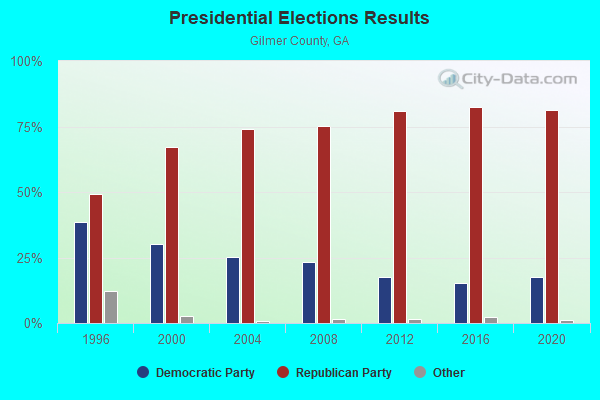
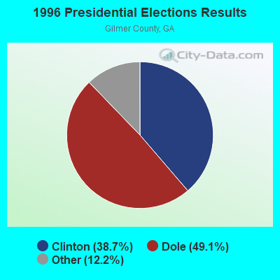
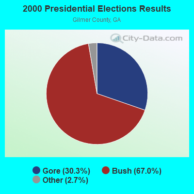
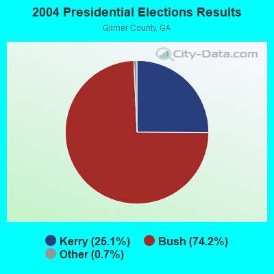
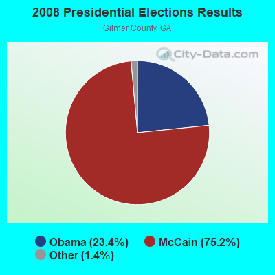
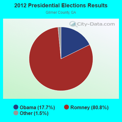
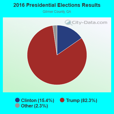
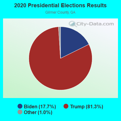
Graphs represent county-level data. Detailed 2008 Election Results
Religion statistics for Cartecay, GA (based on Gilmer County data)
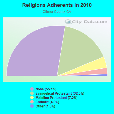
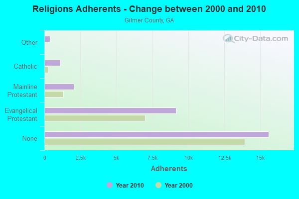
| Religion | Adherents | Congregations |
|---|---|---|
| Evangelical Protestant | 9,152 | 36 |
| Mainline Protestant | 2,043 | 8 |
| Catholic | 1,120 | 1 |
| Other | 381 | 3 |
| None | 15,596 | - |
Food Environment Statistics:
| Gilmer County: | 1.77 / 10,000 pop. |
| Georgia: | 1.91 / 10,000 pop. |
| Here: | 0.35 / 10,000 pop. |
| Georgia: | 0.15 / 10,000 pop. |
| Gilmer County: | 0.71 / 10,000 pop. |
| State: | 0.86 / 10,000 pop. |
| This county: | 5.30 / 10,000 pop. |
| Georgia: | 5.12 / 10,000 pop. |
| Gilmer County: | 7.77 / 10,000 pop. |
| Georgia: | 7.41 / 10,000 pop. |
| Gilmer County: | 10.3% |
| Georgia: | 10.4% |
| Here: | 25.2% |
| Georgia: | 27.8% |
| Here: | 20.9% |
| Georgia: | 14.6% |
Strongest AM radio stations in Cartecay:
- WCNN (680 AM; 50 kW; NORTH ATLANTA, GA; Owner: DICKEY BROADCASTING COMPANY)
- WFTD (1080 AM; daytime; 50 kW; MARIETTA, GA; Owner: PRIETO ENTERPRISES, INC.)
- WSB (750 AM; 50 kW; ATLANTA, GA; Owner: CXR HOLDINGS, INC.)
- WGST (640 AM; 50 kW; ATLANTA, GA; Owner: CITICASTERS LICENSES, L.P.)
- WMLB (1160 AM; 50 kW; EAST POINT, GA; Owner: ATLANTA AREA BROADCASTING, INC.)
- WPGY (1560 AM; daytime; 1 kW; ELLIJAY, GA; Owner: TRI-STATE COMMUNICATIONS, INC.)
- WDGR (1210 AM; daytime; 10 kW; DAHLONEGA, GA; Owner: SMALL TOWN RADIO OF GEORGIA, INC.)
- WAZX (1550 AM; 50 kW; SMYRNA, GA; Owner: GA-MEX BROADCASTING, INC.)
- WFLI (1070 AM; 50 kW; LOOKOUT MOUNTAIN, TN; Owner: WFLI, INC.)
- WGUN (1010 AM; 50 kW; ATLANTA, GA; Owner: WGUN, INC.)
- WQXI (790 AM; 28 kW; ATLANTA, GA; Owner: JEFFERSON-PILOT COMMUNICATIONS COMPANY OF GEORGIA)
- WAOK (1380 AM; 50 kW; ATLANTA, GA; Owner: INFINITY BROADCASTING OPERATIONS, INC.)
- WWAM (820 AM; daytime; 50 kW; JASPER, TN; Owner: SHELTON BROADCASTING SYSTEM)
Strongest FM radio stations in Cartecay:
- WNSY (100.1 FM; TALKING ROCK, GA; Owner: CHARLES A. MCCLURE)
- W234AG (94.7 FM; CHATSWORTH, GA; Owner: IMMANUEL BROADCASTING NETWORK, INC.)
- W221AW (92.1 FM; NORTH CANTON, GA; Owner: IMMANUEL BROADCASTING NETWORK, INC.)
- W214AS (90.7 FM; WALESKA, GA; Owner: CALVARY CHAPEL OF TWIN FALLS, INC.)
- WLJA-FM (93.5 FM; ELLIJAY, GA; Owner: TRI-STATE COMMUNICATIONS, INC.)
- WWEV-FM (91.5 FM; CUMMING, GA; Owner: CURRICULUM DEVELOPMENT FOUNDATION)
- WFOX (97.1 FM; GAINESVILLE, GA; Owner: COX RADIO, INC.)
- WFQS (91.3 FM; FRANKLIN, NC; Owner: WESTERN NORTH CAROLINA PUBLIC RADIO)
- WCVP-FM (95.9 FM; ROBBINSVILLE, NC; Owner: CHEROKEE BROADCASTING COMPANY, INC.)
- WQMT (98.9 FM; CHATSWORTH, GA; Owner: CLEAR CHANNEL BROADCASTING LICENSES, INC.)
- WCCV (91.7 FM; CARTERSVILLE, GA; Owner: IMMANUEL BROADCASTING NETWORK, INC.)
- WYAY (106.7 FM; GAINESVILLE, GA; Owner: ABC, INC.)
- WNGC (106.1 FM; TOCCOA, GA; Owner: SOUTHERN BROADCASTING OF PENSACOLA, INC)
- WPPL (103.9 FM; BLUE RIDGE, GA; Owner: FANNIN COUNTY BROADCASTING CO., INC.)
- WLCL (105.7 FM; CANTON, GA; Owner: CHEROKEE BROADCASTING CO., INC.)
- W215AY (90.9 FM; ELLIJAY, GA; Owner: IMMANUEL BROADCASTING NETWORK, INC.)
- WNGU (89.5 FM; DAHLONEGA, GA; Owner: GEORGIA PUBLIC TELECOMMUNICATIONS COMMISSION)
- W265BD (100.9 FM; WOODSTOCK, GA; Owner: IMMANUEL BROADCASTING NETWORK, INC.)
- WKHC (104.3 FM; DAHLONEGA, GA; Owner: WILLIAMS COMMUNICATIONS, INC.)
TV broadcast stations around Cartecay:
- W50AB (Channel 50; HIAWASSEE, GA; Owner: GEORGIA PUBLIC TELECOMMUNICATIONS COMMISSION)
- WPXA (Channel 14; ROME, GA; Owner: PAXSON ATLANTA LICENSE, INC.)
- WFLI-TV (Channel 53; CLEVELAND, TN; Owner: CHATTANOOGA MEDIA HOLDINGS, L.L.C.)
- WUVG (Channel 34; ATHENS, GA; Owner: UNIVISION ATLANTA LLC)
- WSKC-LP (Channel 59; ATLANTA, GA; Owner: KM LPTV OF ATLANTA, L.L.C.)
- WCLP-TV (Channel 18; CHATSWORTH, GA; Owner: GEORGIA PUBLIC TELECOMMUNICATIONS COMMISSION)

- 62.7%Bottled, tank, or LP gas
- 21.0%Electricity
- 6.4%Wood
- 5.3%Fuel oil, kerosene, etc.
- 3.6%Utility gas
- 0.9%Other fuel

- 58.6%Bottled, tank, or LP gas
- 30.1%Electricity
- 5.9%Utility gas
- 5.5%Fuel oil, kerosene, etc.
Cartecay compared to Georgia state average:
- Unemployed percentage significantly below state average.
- Black race population percentage significantly below state average.
- Hispanic race population percentage below state average.
- Foreign-born population percentage significantly below state average.
- Renting percentage significantly below state average.
- Length of stay since moving in significantly above state average.
- Number of rooms per house significantly below state average.
- House age significantly below state average.
- Number of college students significantly below state average.
- Percentage of population with a bachelor's degree or higher below state average.