Carsonville-Panhandle, Georgia
Submit your own pictures of this place and show them to the world
- OSM Map
- Google Map
- MSN Map
| Males: 832 | |
| Females: 597 |
| Median resident age: | 35.3 years |
| Georgia median age: | 33.4 years |
Zip code: 31006
| Carsonville-Panhandle: | $44,666 |
| GA: | $72,837 |
Estimated per capita income in 2022: $28,786 (it was $15,589 in 2000)
Carsonville-Panhandle CCD income, earnings, and wages data
Estimated median house or condo value in 2022: $140,837 (it was $63,200 in 2000)
| Carsonville-Panhandle: | $140,837 |
| GA: | $297,400 |
Mean prices in 2022: all housing units: $150,127; detached houses: $186,077; mobile homes: $81,547
Carsonville-Panhandle, GA residents, houses, and apartments details
Detailed information about poverty and poor residents in Carsonville-Panhandle, GA


- 92163.3%White alone
- 44030.2%Black alone
- 755.2%Hispanic
- 130.9%Two or more races
- 50.3%Asian alone
- 20.1%American Indian alone

Races in Carsonville-Panhandle detailed stats: ancestries, foreign born residents, place of birth
 Recent articles from our blog. Our writers, many of them Ph.D. graduates or candidates, create easy-to-read articles on a wide variety of topics.
Current Local Time: EST time zone
Land area: 103.3 square miles.
Population density: 14 people per square mile (very low).
| Carsonville-Panhandle CCD: | 1.0% ($606) |
| Georgia: | 0.9% ($919) |
Nearest city with pop. 50,000+: Macon, GA  (37.6 miles , pop. 97,255).
Nearest city with pop. 200,000+: Atlanta, GA (76.7 miles , pop. 416,474).
Nearest city with pop. 1,000,000+: Chicago, IL (662.5 miles , pop. 2,896,016).
Nearest cities:
), Latitude: 32.66 N, Longitude: 84.24 W
Area code commonly used in this area: 478

| Here: | 3.6% |
| Georgia: | 2.9% |

- Health care (13.0%)
- Agriculture, forestry, fishing & hunting (7.1%)
- Public administration (6.8%)
- Finance & insurance (6.4%)
- Broadcasting & telecommunications (6.2%)
- Educational services (5.7%)
- Construction (5.5%)

- Agriculture, forestry, fishing & hunting (9.7%)
- Construction (9.7%)
- Truck transportation (7.7%)
- Health care (5.2%)
- Broadcasting & telecommunications (5.2%)
- Public administration (5.2%)
- Textile mills & textile products (4.8%)

- Health care (23.0%)
- Finance & insurance (14.7%)
- Educational services (9.4%)
- Public administration (8.9%)
- Broadcasting & telecommunications (7.3%)
- Gasoline stations (6.3%)
- Accommodation & food services (4.7%)

- Electrical equipment mechanics and other installation, maintenance, and repair workers, including supervisors (8.7%)
- Driver/sales workers and truck drivers (7.3%)
- Registered nurses (5.7%)
- Textile, apparel, and furnishings workers (5.7%)
- Other production occupations, including supervisors (5.7%)
- Material recording, scheduling, dispatching, and distributing workers (4.8%)
- Secretaries and administrative assistants (4.8%)

- Electrical equipment mechanics and other installation, maintenance, and repair workers, including supervisors (15.3%)
- Driver/sales workers and truck drivers (12.9%)
- Other production occupations, including supervisors (8.1%)
- Material recording, scheduling, dispatching, and distributing workers (6.9%)
- Building and grounds cleaning and maintenance occupations (6.0%)
- Construction traders workers except carpenters, electricians, painters, plumbers, and construction laborers (6.0%)
- Law enforcement workers, including supervisors (5.2%)

- Registered nurses (13.1%)
- Secretaries and administrative assistants (11.0%)
- Bookkeeping, accounting, and auditing clerks (10.5%)
- Other office and administrative support workers, including supervisors (6.8%)
- Textile, apparel, and furnishings workers (6.8%)
- Preschool, kindergarten, elementary, and middle school teachers (6.3%)
- Nursing, psychiatric, and home health aides (6.3%)
Average climate in Carsonville-Panhandle, Georgia
Based on data reported by over 4,000 weather stations


Tornado activity:
Carsonville-Panhandle-area historical tornado activity is near Georgia state average. It is 33% greater than the overall U.S. average.
On 3/13/1954, a category F3 (max. wind speeds 158-206 mph) tornado 11.6 miles away from the Carsonville-Panhandle place center killed 5 people and injured 75 people and caused between $500,000 and $5,000,000 in damages.
On 12/25/1964, a category F3 tornado 14.7 miles away from the place center killed 2 people and injured 16 people and caused between $500,000 and $5,000,000 in damages.
Earthquake activity:
Carsonville-Panhandle-area historical earthquake activity is significantly above Georgia state average. It is 20% greater than the overall U.S. average.On 8/2/1974 at 08:52:09, a magnitude 4.9 (4.3 MB, 4.9 LG, Class: Light, Intensity: IV - V) earthquake occurred 131.6 miles away from the city center
On 4/29/2003 at 08:59:39, a magnitude 4.9 (4.4 MB, 4.6 MW, 4.9 LG) earthquake occurred 150.0 miles away from Carsonville-Panhandle center
On 1/18/1999 at 07:00:53, a magnitude 4.8 (4.8 MB, 4.0 LG, Depth: 0.6 mi) earthquake occurred 182.2 miles away from Carsonville-Panhandle center
On 10/24/1997 at 08:35:17, a magnitude 4.9 (4.8 MB, 4.2 MS, 4.9 LG, Depth: 6.2 mi) earthquake occurred 207.3 miles away from Carsonville-Panhandle center
On 4/29/2003 at 08:59:39, a magnitude 4.6 (4.6 MW, Depth: 12.3 mi) earthquake occurred 150.0 miles away from the city center
On 11/30/1973 at 07:48:41, a magnitude 4.7 (4.7 MB, 4.6 ML) earthquake occurred 217.8 miles away from the city center
Magnitude types: regional Lg-wave magnitude (LG), body-wave magnitude (MB), local magnitude (ML), surface-wave magnitude (MS), moment magnitude (MW)
Natural disasters:
The number of natural disasters in Taylor County (9) is smaller than the US average (15).Major Disasters (Presidential) Declared: 6
Emergencies Declared: 2
Causes of natural disasters: Floods: 4, Storms: 3, Tornadoes: 2, Tropical Storms: 2, Drought: 1, Heavy Rain: 1, Hurricane: 1, Other: 1 (Note: some incidents may be assigned to more than one category).
Colleges/universities with over 2000 students nearest to Carsonville-Panhandle:
- Fort Valley State University (about 22 miles; Fort Valley, GA; Full-time enrollment: 3,200)
- Gordon State College (about 28 miles; Barnesville, GA; FT enrollment: 3,336)
- Middle Georgia State College (about 32 miles; Macon, GA; FT enrollment: 7,091)
- Central Georgia Technical College (about 35 miles; Warner Robins, GA; FT enrollment: 6,829)
- Mercer University (about 37 miles; Macon, GA; FT enrollment: 6,297)
- Southern Crescent Technical College (about 42 miles; Griffin, GA; FT enrollment: 4,168)
- Georgia Southwestern State University (about 42 miles; Americus, GA; FT enrollment: 2,689)
Points of interest:
Notable locations in Carsonville-Panhandle: Taylor County Holiness Camp Ground (A), Central Fire Department (B), Panhandle Volunteer Fire Department (C). Display/hide their locations on the map
Churches in Carsonville-Panhandle include: Bethel Church (A), Crowells Church (B), Damascus Church (C), Zion Hill Church (D), Wesley Church (E), Midway Church (F), Mount Gilliard Church (G), Antioch Church (H), Turners Chapel (I). Display/hide their locations on the map
Cemeteries: Antioch Cemetery (1), Chambliss Cemetery (2), Crowell Cemetery (3), Scott-Bussy Cemetery (4), Turners Chapel Cemetery (5), Wainwright Cemetery (6), Wesley Cemetery (7). Display/hide their locations on the map
Reservoirs: Bell Lake (A), Lake Mary (B). Display/hide their locations on the map
Creeks: Timms Creek (A), Duck Creek (B), Little Patsiliga Creek (C). Display/hide their locations on the map
| This place: | 2.6 people |
| Georgia: | 2.6 people |
| This place: | 65.7% |
| Whole state: | 70.7% |
| This place: | 3.3% |
| Whole state: | 4.8% |
Likely homosexual households (counted as self-reported same-sex unmarried-partner households)
- Lesbian couples: 0.2% of all households
- Gay men: 0.4% of all households
| This place: | 15.7% |
| Whole state: | 13.0% |
| This place: | 3.8% |
| Whole state: | 6.1% |
64 people in agriculture workers' dormitories on farms in 2000
For population 15 years and over in Carsonville-Panhandle:

- Never married: 30.0%
- Now married: 51.2%
- Separated: 2.1%
- Widowed: 8.1%
- Divorced: 10.7%
For population 25 years and over in Carsonville-Panhandle:
- High school or higher: 70.8%
- Bachelor's degree or higher: 5.0%
- Graduate or professional degree: 1.4%
- Unemployed: 2.9%
- Mean travel time to work (commute): 31.4 minutes


| Here: | 11.7 |
| Georgia average: | 13.3 |
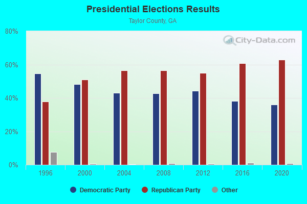
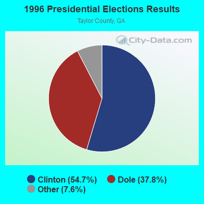
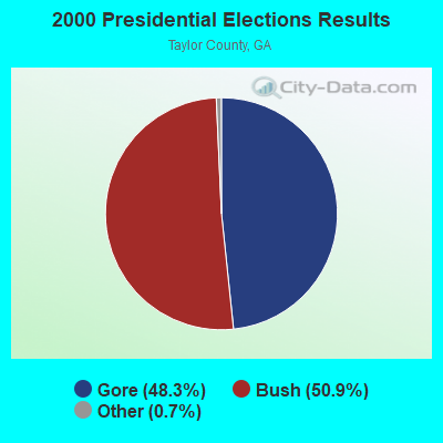

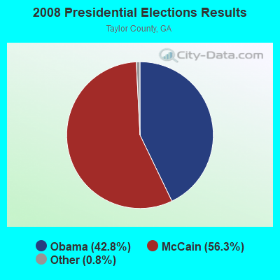
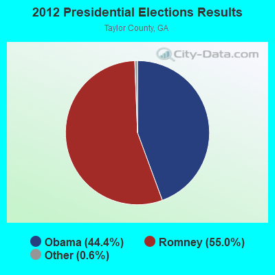
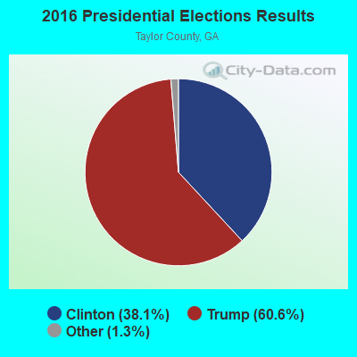

Graphs represent county-level data. Detailed 2008 Election Results
Religion statistics for Carsonville-Panhandle, GA (based on Taylor County data)
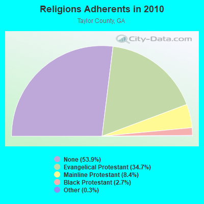
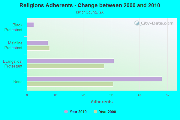
| Religion | Adherents | Congregations |
|---|---|---|
| Evangelical Protestant | 3,087 | 16 |
| Mainline Protestant | 744 | 10 |
| Black Protestant | 243 | 3 |
| Other | 30 | - |
| None | 4,802 | - |
Food Environment Statistics:
| Here: | 5.74 / 10,000 pop. |
| Georgia: | 1.91 / 10,000 pop. |
| This county: | 1.15 / 10,000 pop. |
| State: | 0.86 / 10,000 pop. |
| Here: | 4.59 / 10,000 pop. |
| Georgia: | 5.12 / 10,000 pop. |
| Taylor County: | 3.45 / 10,000 pop. |
| Georgia: | 7.41 / 10,000 pop. |
| This county: | 14.1% |
| Georgia: | 10.4% |
| This county: | 30.9% |
| Georgia: | 27.8% |
| Taylor County: | 14.6% |
| State: | 14.6% |
Strongest AM radio stations in Carsonville-Panhandle:
- WMAC (940 AM; 50 kW; MACON, GA; Owner: CUMULUS LICENSING CORP.)
- WGST (640 AM; 50 kW; ATLANTA, GA; Owner: CITICASTERS LICENSES, L.P.)
- WSB (750 AM; 50 kW; ATLANTA, GA; Owner: CXR HOLDINGS, INC.)
- WGUN (1010 AM; 50 kW; ATLANTA, GA; Owner: WGUN, INC.)
- WNNG (1350 AM; 15 kW; WARNER ROBINS, GA; Owner: CHASE BROADCASTING, INC.)
- WCNN (680 AM; 50 kW; NORTH ATLANTA, GA; Owner: DICKEY BROADCASTING COMPANY)
- WMLB (1160 AM; 50 kW; EAST POINT, GA; Owner: ATLANTA AREA BROADCASTING, INC.)
- WAOK (1380 AM; 50 kW; ATLANTA, GA; Owner: INFINITY BROADCASTING OPERATIONS, INC.)
- WPGA (980 AM; 5 kW; PERRY, GA; Owner: RADIO PERRY, INC.)
- WQXI (790 AM; 28 kW; ATLANTA, GA; Owner: JEFFERSON-PILOT COMMUNICATIONS COMPANY OF GEORGIA)
- WKNG (1060 AM; daytime; 50 kW; TALLAPOOSA, GA; Owner: WKNG, INC.)
- WFTD (1080 AM; daytime; 50 kW; MARIETTA, GA; Owner: PRIETO ENTERPRISES, INC.)
- WAZX (1550 AM; 50 kW; SMYRNA, GA; Owner: GA-MEX BROADCASTING, INC.)
Strongest FM radio stations in Carsonville-Panhandle:
- WVFJ-FM (93.3 FM; MANCHESTER, GA; Owner: PROVIDENT BROADCASTING COMPANY)
- WKEU-FM (88.9 FM; THE ROCK, GA; Owner: GEORGIA FOUNDATION OF PUBLIC BROADCASTING, INC.)
- WJSP-FM (88.1 FM; WARM SPRINGS, GA; Owner: GEORGIA PUBLIC TELECOMMUNICATIONS COMMISSION)
- WKZJ (95.7 FM; GREENVILLE, GA; Owner: DAVIS B/CASTING OF COLUMBUS, INC)
- WJTG (91.3 FM; FORT VALLEY, GA; Owner: JOY PUBLIC B/CNG CORP)
- WTGA-FM (101.1 FM; THOMASTON, GA; Owner: RADIO GEORGIA, INC.)
- WQMJ (100.1 FM; FORSYTH, GA; Owner: ROBERTS COMMUNICATIONS, INC.)
- WIBB-FM (97.9 FM; FORT VALLEY, GA; Owner: CLEVELAND RADIO LICENSES, LLC)
- WYNF (96.5 FM; GRAY, GA; Owner: CLEVELAND RADIO LICENSES, LLC)
- WQBZ (106.3 FM; FORT VALLEY, GA; Owner: CLEVELAND RADIO LICENSES, LLC)
TV broadcast stations around Carsonville-Panhandle:
- WTVM (Channel 9; COLUMBUS, GA; Owner: RAYCOM AMERICA, INC.)
- WRBL (Channel 3; COLUMBUS, GA; Owner: MEDIA GENERAL BROADCASTING OF SO. CAROLINA HOLDINGS, INC.)
- WJSP-TV (Channel 28; COLUMBUS, GA; Owner: GEORGIA PUBLIC TELECOMMUNICATIONS COMMISSION)
- WLTZ (Channel 38; COLUMBUS, GA; Owner: LEWIS BROADCASTING CORPORATION)
- WXTX (Channel 54; COLUMBUS, GA; Owner: FISHER BROADCASTING - GEORGIA, L.L.C.)
- WDMA-LP (Channel 32; MACON, GA; Owner: WORD OF GOD FELLOWSHIP, INC.)
- WPGA-TV (Channel 58; PERRY, GA; Owner: RADIO PERRY, INC.)
- WMGT-TV (Channel 41; MACON, GA; Owner: MORRIS NETWORK, INC.)
- WMAZ-TV (Channel 13; MACON, GA; Owner: GANNETT GEORGIA, L.P.)
- WGXA (Channel 24; MACON, GA; Owner: PIEDMONT TELEVISION OF MACON LICENSE LLC)
- National Bridge Inventory (NBI) Statistics
- 1Number of bridges
- 3ft / 1.0mTotal length
- $193,000Total costs
- 1,420Total average daily traffic
- 14Total average daily truck traffic
- 2,130Total future (year 2031) average daily traffic

- 70.8%Bottled, tank, or LP gas
- 19.3%Electricity
- 4.1%Utility gas
- 4.1%Wood
- 1.8%Fuel oil, kerosene, etc.

- 88.5%Bottled, tank, or LP gas
- 11.5%Electricity
Carsonville-Panhandle compared to Georgia state average:
- Median household income below state average.
- Median house value below state average.
- Unemployed percentage significantly below state average.
- Hispanic race population percentage below state average.
- Median age below state average.
- Foreign-born population percentage significantly below state average.
- Renting percentage significantly below state average.
- Length of stay since moving in significantly above state average.
- Number of rooms per house significantly below state average.
- House age significantly below state average.
- Institutionalized population percentage significantly above state average.
- Number of college students below state average.
- Percentage of population with a bachelor's degree or higher significantly below state average.
Carsonville-Panhandle on our top lists:
- #18 on the list of "Top 101 cities with the largest percentage of people in agriculture workers' dormitories on farms (population 1,000+)"