Carr Fork, Kentucky
Submit your own pictures of this place and show them to the world
- OSM Map
- General Map
- Google Map
- MSN Map

| Males: 2,170 | |
| Females: 2,234 |
| Median resident age: | 36.8 years |
| Kentucky median age: | 35.9 years |
Zip code: 41773
| Carr Fork: | $38,395 |
| KY: | $59,341 |
Estimated per capita income in 2022: $22,299 (it was $12,099 in 2000)
Carr Fork CCD income, earnings, and wages data
Estimated median house or condo value in 2022: $75,698 (it was $37,100 in 2000)
| Carr Fork: | $75,698 |
| KY: | $196,300 |
Detailed information about poverty and poor residents in Carr Fork, KY


- 4,38296.5%White alone
- 1032.3%Black alone
- 290.6%Hispanic
- 170.4%Two or more races
- 50.1%American Indian alone
- 10.02%Asian alone
- 10.02%Native Hawaiian and Other
Pacific Islander alone - 10.02%Other race alone

Races in Carr Fork detailed stats: ancestries, foreign born residents, place of birth
 Recent articles from our blog. Our writers, many of them Ph.D. graduates or candidates, create easy-to-read articles on a wide variety of topics.
Current Local Time: EST time zone
Land area: 80.2 square miles.
Population density: 55 people per square mile (very low).

| Carr Fork CCD: | 0.8% ($280) |
| Kentucky: | 0.8% ($610) |
Nearest city with pop. 50,000+: Johnson City, TN  (72.1 miles , pop. 55,469).
Nearest city with pop. 200,000+: Fayette, KY (98.2 miles , pop. 260,512).
Nearest city with pop. 1,000,000+: Chicago, IL (403.9 miles , pop. 2,896,016).
Nearest cities:
), ), ), ), )Latitude: 37.25 N, Longitude: 83.00 W
Area code commonly used in this area: 606


| Here: | 6.2% |
| Kentucky: | 3.8% |

- Health care (15.2%)
- Educational services (14.9%)
- Mining, quarrying, oil & gas extraction (13.6%)
- Public administration (5.3%)
- Construction (5.2%)
- Food & beverage stores (4.9%)
- Accommodation & food services (4.3%)

- Mining, quarrying, oil & gas extraction (25.9%)
- Construction (9.1%)
- Educational services (9.1%)
- Health care (8.6%)
- Public administration (4.6%)
- Truck transportation (4.6%)
- Administrative & support & waste management services (4.0%)

- Health care (22.5%)
- Educational services (21.3%)
- Food & beverage stores (9.3%)
- Accommodation & food services (9.0%)
- Public administration (6.1%)
- Social assistance (4.0%)
- Finance & insurance (3.1%)

- Driver/sales workers and truck drivers (6.2%)
- Extraction workers (5.9%)
- Other sales and related occupations, including supervisors (4.8%)
- Building and grounds cleaning and maintenance occupations (4.6%)
- Health technologists and technicians (4.3%)
- Preschool, kindergarten, elementary, and middle school teachers (4.1%)
- Other production occupations, including supervisors (3.6%)

- Driver/sales workers and truck drivers (11.9%)
- Extraction workers (11.2%)
- Other sales and related occupations, including supervisors (5.9%)
- Building and grounds cleaning and maintenance occupations (5.3%)
- Laborers and material movers, hand (4.8%)
- Other production occupations, including supervisors (4.7%)
- Construction traders workers except carpenters, electricians, painters, plumbers, and construction laborers (4.1%)

- Preschool, kindergarten, elementary, and middle school teachers (8.6%)
- Registered nurses (7.6%)
- Cooks and food preparation workers (7.0%)
- Cashiers (6.4%)
- Other office and administrative support workers, including supervisors (5.2%)
- Other management occupations, except farmers and farm managers (4.7%)
- Health technologists and technicians (4.7%)
Average climate in Carr Fork, Kentucky
Based on data reported by over 4,000 weather stations


(lower is better)

Air Quality Index (AQI) level in 2022 was 81.6. This is about average.
| City: | 81.6 |
| U.S.: | 72.6 |

Ozone [ppb] level in 2022 was 24.9. This is better than average. Closest monitor was 10.1 miles away from the city center.
| City: | 24.9 |
| U.S.: | 33.3 |

Particulate Matter (PM2.5) [µg/m3] level in 2022 was 9.26. This is about average. Closest monitor was 11.9 miles away from the city center.
| City: | 9.26 |
| U.S.: | 8.11 |
Tornado activity:
Carr Fork-area historical tornado activity is significantly below Kentucky state average. It is 69% smaller than the overall U.S. average.
On 5/18/1995, a category F2 (max. wind speeds 113-157 mph) tornado 7.4 miles away from the Carr Fork place center caused between $50,000 and $500,000 in damages.
On 6/9/1961, a category F3 (max. wind speeds 158-206 mph) tornado 51.4 miles away from the place center killed one person and injured 63 people and caused between $500,000 and $5,000,000 in damages.
Earthquake activity:
Carr Fork-area historical earthquake activity is significantly above Kentucky state average. It is 37% greater than the overall U.S. average.On 7/27/1980 at 18:52:21, a magnitude 5.2 (5.1 MB, 4.7 MS, 5.0 UK, 5.2 UK, Class: Moderate, Intensity: VI - VII) earthquake occurred 83.9 miles away from the city center
On 8/9/2020 at 12:07:37, a magnitude 5.1 (5.1 MW, Depth: 4.7 mi) earthquake occurred 118.2 miles away from the city center
On 8/23/2011 at 17:51:04, a magnitude 5.8 (5.8 MW, Depth: 3.7 mi) earthquake occurred 281.1 miles away from the city center
On 9/7/1988 at 02:28:09, a magnitude 4.6 (4.5 MB, 4.6 LG, Class: Light, Intensity: IV - V) earthquake occurred 78.4 miles away from Carr Fork center
On 11/30/1973 at 07:48:41, a magnitude 4.7 (4.7 MB, 4.6 ML) earthquake occurred 113.8 miles away from Carr Fork center
On 11/10/2012 at 17:08:14, a magnitude 4.2 (4.2 MW, Depth: 10.6 mi) earthquake occurred 8.3 miles away from Carr Fork center
Magnitude types: regional Lg-wave magnitude (LG), body-wave magnitude (MB), local magnitude (ML), surface-wave magnitude (MS), moment magnitude (MW)
Natural disasters:
The number of natural disasters in Knott County (33) is a lot greater than the US average (15).Major Disasters (Presidential) Declared: 28
Emergencies Declared: 2
Causes of natural disasters: Floods: 28, Storms: 23, Mudslides: 12, Tornadoes: 10, Landslides: 7, Winter Storms: 4, Winds: 3, Snowstorms: 2, Blizzard: 1, Heavy Rain: 1, Hurricane: 1, Snow: 1, Snowfall: 1, Other: 1 (Note: some incidents may be assigned to more than one category).
Hospitals and medical centers near Carr Fork:
- KNOTT COUNTY HEALTH AND REHABILITATION CENTER (Nursing Home, about 6 miles away; HINDMAN, KY)
- KENTUCKY RIVER DISTRICT HHA (Home Health Center, about 7 miles away; HINDMAN, KY)
- MOUNTAIN COMMUNITY HOSPICE (Hospital, about 11 miles away; HAZARD, KY)
- HAZARD HEALTH AND REHABILITATION CENTER (Nursing Home, about 13 miles away; HAZARD, KY)
- LETCHER MANOR (Nursing Home, about 15 miles away; WHITESBURG, KY)
Colleges/universities with over 2000 students nearest to Carr Fork:
- Hazard Community and Technical College (about 10 miles; Hazard, KY; Full-time enrollment: 2,087)
- Southeast Kentucky Community and Technical College (about 20 miles; Cumberland, KY; FT enrollment: 2,196)
- Big Sandy Community and Technical College (about 33 miles; Prestonsburg, KY; FT enrollment: 2,660)
- Lincoln Memorial University (about 59 miles; Harrogate, TN; FT enrollment: 3,706)
- Northeast State Community College (about 63 miles; Blountville, TN; FT enrollment: 4,480)
- King University (about 66 miles; Bristol, TN; FT enrollment: 2,472)
- Morehead State University (about 70 miles; Morehead, KY; FT enrollment: 7,523)
Points of interest:
Notable locations in Carr Fork: Elic (A), Carr Creek Volunteer Fire Department (B), Lotts Creek Volunteer Fire Department (C). Display/hide their locations on the map
Churches in Carr Fork include: Kelly Fork Church of God (A), Little Dove Old Regular Baptist Church (B), Mallet Regular Baptist Church (C), Happy Home of Regular Baptist Church (D), Cody Bible Church (E), Little Home Church (F), Old Carr Church (G), Happy Home Church (H), Lotts Creek United Baptist Church (I). Display/hide their locations on the map
Cemeteries: Cornett Hill Cemetery (1), Christon Cemetery (2), Upper Kelly Cemetery (3), Franklin Cemetery (4), Madden Cemetery (5). Display/hide their locations on the map
Reservoir: Carr Fork Lake (A). Display/hide its location on the map
Streams, rivers, and creeks: Alum Cave Branch (A), Bee Branch (B), Big Branch (C), Big Doubles Branch (D), Big Fork (E), Black John Branch (F), Blair Branch (G), Dickson Branch (H), Branhams Branch (I). Display/hide their locations on the map
Parks in Carr Fork include: Carr Creek State Park (1), Carr Fork Lake State Wildlife Management Areas (2). Display/hide their locations on the map
| This place: | 2.5 people |
| Kentucky: | 2.5 people |
| This place: | 70.7% |
| Whole state: | 66.9% |
| This place: | 5.0% |
| Whole state: | 6.4% |
Likely homosexual households (counted as self-reported same-sex unmarried-partner households)
- Lesbian couples: 0.1% of all households
- Gay men: 0.1% of all households
| This place: | 29.1% |
| Whole state: | 15.8% |
| This place: | 14.0% |
| Whole state: | 6.6% |
For population 15 years and over in Carr Fork:

- Never married: 20.3%
- Now married: 62.8%
- Separated: 1.2%
- Widowed: 9.3%
- Divorced: 7.7%
For population 25 years and over in Carr Fork:
- High school or higher: 60.0%
- Bachelor's degree or higher: 7.7%
- Graduate or professional degree: 3.2%
- Unemployed: 12.4%
- Mean travel time to work (commute): 29.8 minutes


| Here: | 16.5 |
| Kentucky average: | 13.8 |
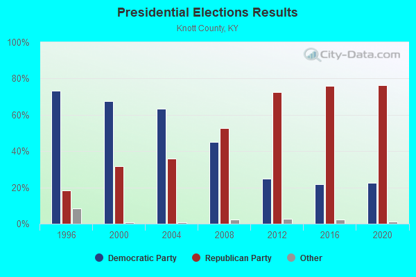
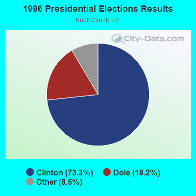
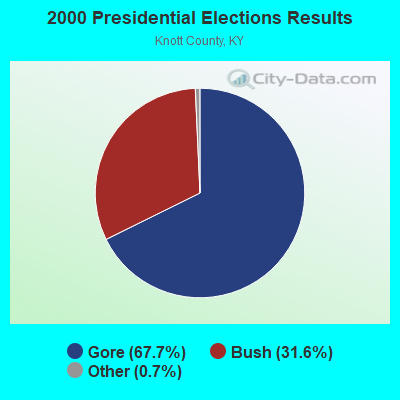
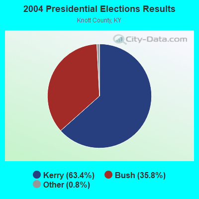
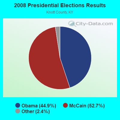
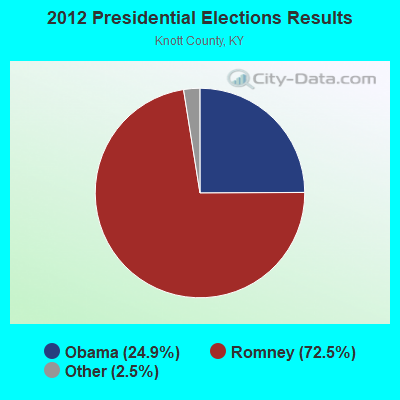
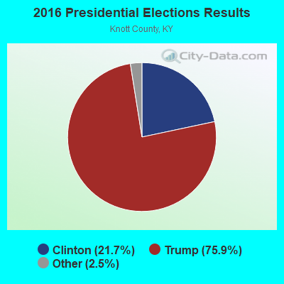
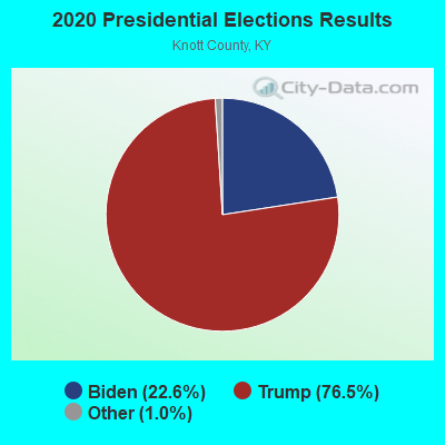
Graphs represent county-level data. Detailed 2008 Election Results
Religion statistics for Carr Fork, KY (based on Knott County data)
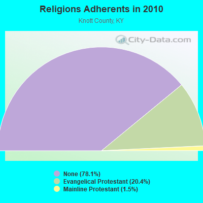
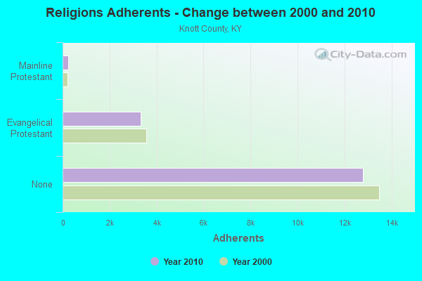
| Religion | Adherents | Congregations |
|---|---|---|
| Evangelical Protestant | 3,332 | 11 |
| Mainline Protestant | 243 | 1 |
| Other | 1 | 1 |
| None | 12,770 | - |
Food Environment Statistics:
| Here: | 3.48 / 10,000 pop. |
| State: | 2.19 / 10,000 pop. |
| This county: | 0.58 / 10,000 pop. |
| Kentucky: | 0.74 / 10,000 pop. |
| Knott County: | 3.48 / 10,000 pop. |
| State: | 4.36 / 10,000 pop. |
| Knott County: | 0.58 / 10,000 pop. |
| Kentucky: | 5.74 / 10,000 pop. |
| Knott County: | 13.0% |
| Kentucky: | 11.0% |
| Here: | 32.0% |
| Kentucky: | 30.0% |
| Here: | 22.6% |
| State: | 15.9% |
Strongest AM radio stations in Carr Fork:
- WKIC (1390 AM; 5 kW; HAZARD, KY)
- WKCB (1340 AM; 1 kW; HINDMAN, KY; Owner: HINDMAN BROADCASTING CORPORATION)
- WTCW (920 AM; 4 kW; WHITESBURG, KY; Owner: T.C.W. BROADCASTING , INC.)
- WEZC (1480 AM; daytime; 5 kW; NEON, KY; Owner: JESUS COMMUNICATION ILNC.)
- WLSI (900 AM; 5 kW; PIKEVILLE, KY; Owner: EAST KENTUCKY BROADCASTING CORPORATION)
- WKVL (850 AM; daytime; 50 kW; KNOXVILLE, TN; Owner: HORNE RADIO, LLC)
- WPRT (960 AM; 5 kW; PRESTONSBURG, KY; Owner: EAST KENTUCKY RADIO NETWORK, INC.)
- WEKG (810 AM; daytime; 5 kW; JACKSON, KY; Owner: INTERMOUNTAIN B/CING CO., INC.)
- WQXY (1560 AM; daytime; 1 kW; HAZARD, KY; Owner: BLACK GOLD BROADCASTING)
- WMTC (730 AM; 5 kW; VANCLEVE, KY; Owner: THE KENTUCKY MOUNTAIN HOLINESS ASSN.)
- WKYH (600 AM; 5 kW; PAINTSVILLE, KY; Owner: HIGHLANDS BROADCASTING CORPORATION)
- WFSR (970 AM; 5 kW; HARLAN, KY; Owner: EASTERN BROADCASTING COMPAY)
- WNVA (1350 AM; 5 kW; NORTON, VA; Owner: RADIO-WISE, INC.)
Strongest FM radio stations in Carr Fork:
- WSGS (101.1 FM; HAZARD, KY; Owner: MOUNTAIN BROADCASTING SERVICE, INC.)
- WKCB-FM (107.1 FM; HINDMAN, KY; Owner: HINDMAN BROADCASTING CORPORATION)
- WZQQ (97.9 FM; HYDEN, KY; Owner: LESLIE COUNTY BROADCASTING, INC.)
- WJMD (104.7 FM; HAZARD, KY; Owner: HAZARD BROADCASTING SERVICES)
- WEKH (90.9 FM; HAZARD, KY; Owner: EASTERN KENTUCKY UNIVERSITY)
- WSEH (102.7 FM; CUMBERLAND, KY; Owner: CUMBERLAND CITY BROADCASTING, INC.)
- WIFX-FM (94.3 FM; JENKINS, KY; Owner: LETCHER COUNTY BROADCASTING, INC)
- WXKQ-FM (103.9 FM; WHITESBURG, KY; Owner: T.C.W. BROADCASTING , INC.)
- WMMT (88.7 FM; WHITESBURG, KY; Owner: APPALSHOP, INCORPORATED)
- WWJD (91.7 FM; PIPPA PASSES, KY; Owner: ALICE LLOYD COLLEGE)
- WAXM (93.5 FM; BIG STONE GAP, VA; Owner: VALLEY BROADCASTING, INC.)
- WDXC (102.3 FM; POUND, VA; Owner: WDXC RADIO, INC.)
- W223AA (92.5 FM; BIG STONE GAP, VA; Owner: VALLEY BROADCASTING, INC.)
- WPKE-FM (103.1 FM; COAL RUN, KY; Owner: EAST KENTUCKY BROADCASTING CORP.)
- WTUK (105.1 FM; HARLAN, KY; Owner: EASTERN BROADCASTING COMPANY)
- WTFM (98.5 FM; KINGSPORT, TN; Owner: HOLSTON VALLEY BROADCASTING CORP.)
- WZLK (107.5 FM; VIRGIE, KY; Owner: EAST KENTUCKY BROADCASTING CORPORATION)
- WDHR (93.1 FM; PIKEVILLE, KY; Owner: EAST KENTUCKY BROADCASTING CORP.)
- WQHY (95.5 FM; PRESTONSBURG, KY; Owner: WDOC, INC.)
- WJSN-FM (106.5 FM; JACKSON, KY; Owner: INTERMOUNTAIN BROADCASTING CO.)
TV broadcast stations around Carr Fork:
- W24BT (Channel 24; TALBERT, KY; Owner: MS COMMUNICATIONS, LLC)
- WYMT-TV (Channel 57; HAZARD, KY; Owner: WYMT LICENSEE CORP.)
- W31BU (Channel 31; TALBERT, KY; Owner: MS COMMUNICATIONS, LLC)
- W53BQ (Channel 53; TALBERT, KY; Owner: MS COMMUNICATIONS, LLC)
- W69ED (Channel 69; TALBERT, KY; Owner: MS COMMUNICATIONS, LLC)
- WKHA (Channel 35; HAZARD, KY; Owner: KENTUCKY AUTHORITY FOR EDUCATIONAL TV)
- W26BK (Channel 26; TALBERT, KY; Owner: MS COMMUNICATIONS, LLC)
- W16BI (Channel 16; TALBERT, KY; Owner: MS COMMUNICATIONS, LLC)
- W20BO (Channel 20; TALBERT, KY; Owner: MS COMMUNICATIONS, LLC)
- W64CM (Channel 64; TALBERT, KY; Owner: MS COMMUNICATIONS, LLC)
- W66DA (Channel 66; TALBERT, KY; Owner: MS COMMUNICATIONS, LLC)

- 60.2%Electricity
- 27.8%Utility gas
- 4.5%Coal or coke
- 3.5%Fuel oil, kerosene, etc.
- 2.0%Bottled, tank, or LP gas
- 2.0%Wood

- 57.1%Electricity
- 31.5%Utility gas
- 7.6%Coal or coke
- 2.2%Fuel oil, kerosene, etc.
- 1.6%Wood
Carr Fork compared to Kentucky state average:
- Median household income below state average.
- Median house value significantly below state average.
- Black race population percentage significantly below state average.
- Hispanic race population percentage significantly below state average.
- Median age below state average.
- Foreign-born population percentage significantly below state average.
- Renting percentage below state average.
- Length of stay since moving in significantly above state average.
- Number of rooms per house significantly below state average.
- House age significantly below state average.
- Percentage of population with a bachelor's degree or higher significantly below state average.