Estimated median house or condo value in 2022: $67,120 (it was $34,700 in 2000)
Caldwell:
$67,120
KS:
$206,600
Mean prices in 2022:all housing units: $171,482; detached houses: $174,844; townhouses or other attached units: $231,992; in 2-unit structures: $94,669; mobile homes: $90,179
Median gross rent in 2022: $599.
March 2022 cost of living index in Caldwell: 77.5 (low, U.S. average is 100)
Percentage of residents living in poverty in 2022: 19.1%
(16.1% for White Non-Hispanic residents, 9.1% for Hispanic or Latino residents, 15.8% for other race residents, 43.4% for two or more races residents)
According to our research of Kansas and other state lists, there was 1 registered sex offender living in Caldwell, Kansas as of May 23, 2024. The ratio of all residents to sex offenders in Caldwell is 1,140 to 1. The ratio of registered sex offenders to all residents in this city is much lower than the state average.
Crime rates in Caldwell by year
Type
2009
2010
2011
2012
2013
2014
2015
2016
2017
2018
2019
2020
2021
2022
Murders (per 100,000)
0 (0.0)
0 (0.0)
0 (0.0)
0 (0.0)
0 (0.0)
0 (0.0)
0 (0.0)
0 (0.0)
0 (0.0)
0 (0.0)
0 (0.0)
0 (0.0)
0 (0.0)
0 (0.0)
Rapes (per 100,000)
0 (0.0)
1 (93.6)
0 (0.0)
0 (0.0)
0 (0.0)
0 (0.0)
1 (97.5)
0 (0.0)
0 (0.0)
0 (0.0)
0 (0.0)
0 (0.0)
0 (0.0)
0 (0.0)
Robberies (per 100,000)
0 (0.0)
0 (0.0)
0 (0.0)
0 (0.0)
0 (0.0)
0 (0.0)
0 (0.0)
0 (0.0)
0 (0.0)
0 (0.0)
0 (0.0)
0 (0.0)
0 (0.0)
0 (0.0)
Assaults (per 100,000)
0 (0.0)
3 (280.9)
6 (558.1)
2 (189.2)
2 (193.1)
0 (0.0)
13 (1,267)
0 (0.0)
0 (0.0)
4 (399.6)
3 (303.0)
1 (102.2)
0 (0.0)
3 (295.6)
Burglaries (per 100,000)
6 (531.0)
4 (374.5)
4 (372.1)
0 (0.0)
0 (0.0)
0 (0.0)
0 (0.0)
0 (0.0)
0 (0.0)
2 (199.8)
4 (404.0)
4 (409.0)
2 (207.7)
3 (295.6)
Thefts (per 100,000)
12 (1,062)
8 (749.1)
3 (279.1)
1 (94.6)
0 (0.0)
0 (0.0)
0 (0.0)
0 (0.0)
2 (197.4)
8 (799.2)
11 (1,111)
8 (818.0)
4 (415.4)
8 (788.2)
Auto thefts (per 100,000)
3 (265.5)
1 (93.6)
1 (93.0)
1 (94.6)
1 (96.5)
0 (0.0)
0 (0.0)
0 (0.0)
0 (0.0)
0 (0.0)
0 (0.0)
0 (0.0)
2 (207.7)
0 (0.0)
Arson (per 100,000)
0 (0.0)
0 (0.0)
1 (93.0)
0 (0.0)
0 (0.0)
1 (97.3)
0 (0.0)
0 (0.0)
0 (0.0)
0 (0.0)
0 (0.0)
0 (0.0)
0 (0.0)
0 (0.0)
City-Data.com crime index
100.9
194.8
156.3
49.2
46.3
0.0
331.4
0.0
7.9
125.9
133.3
81.8
47.8
111.3
The City-Data.com crime index weighs serious crimes and violent crimes more heavily. Higher means more crime, U.S. average is 246.1. It adjusts for the number of visitors and daily workers commuting into cities.
Latest news from Caldwell, KS collected exclusively by city-data.com from local newspapers, TV, and radio stations
Ancestries: German (43.0%), English (6.9%), European (4.2%), American (4.0%), French (2.5%), Czech (1.7%).
Current Local Time: CST time zone
Elevation: 1149 feet
Land area: 1.10 square miles.
Population density: 926 people per square mile (low).
2 residents are foreign born
This city:
0.2%
Kansas:
7.1%
Median real estate property taxes paid for housing units with mortgages in 2022: $2,019 (2.2%) Median real estate property taxes paid for housing units with no mortgage in 2022: $1,157 (2.0%)
Nearest city with pop. 50,000+: Wichita, KS (47.7 miles , pop. 344,284).
Nearest city with pop. 1,000,000+: Dallas, TX (296.6 miles , pop. 1,188,580).
Air Quality Index (AQI) level in 2020 was 60.5. This is about average.
City:
60.5
U.S.:
72.6
Particulate Matter (PM2.5) [µg/m3] level in 2020 was 8.33. This is about average.Closest monitor was 16.0 miles away from the city center.
City:
8.33
U.S.:
8.11
Tornado activity:
Caldwell-area historical tornado activity is slightly above Kansas state average. It is 122% greater than the overall U.S. average.
On 5/25/1955, a category F5 (max. wind speeds 261-318 mph) tornado 11.8 miles away from the Caldwell city center killed 20 peopleand injured 280 peopleand causedbetween $5,000,000 and $50,000,000 in damages.
On 5/25/1955, a category F5 tornado 27.5 miles away from the city center killed 80 peopleand injured 273 peopleand causedbetween $50,000 and $500,000 in damages.
Earthquake activity:
Caldwell-area historical earthquake activity is significantly above Kansas state average. It is 922% greater than the overall U.S. average.
On 9/3/2016 at 12:02:44, a magnitude 5.8 (5.8 MW, Depth: 3.5 mi, Class: Moderate, Intensity: VI - VII) earthquake occurred 56.5 miles away from the city center On 11/6/2011 at 03:53:10, a magnitude 5.7 (5.7 MW, Depth: 3.2 mi) earthquake occurred 114.1 miles away from Caldwell center On 11/12/2014 at 21:40:00, a magnitude 4.9 (4.9 MW, Depth: 2.5 mi, Class: Light, Intensity: IV - V) earthquake occurred 16.4 miles away from Caldwell center On 2/13/2016 at 17:07:06, a magnitude 5.1 (5.1 MW, Depth: 5.2 mi) earthquake occurred 71.6 miles away from the city center On 11/7/2016 at 01:44:24, a magnitude 5.0 (5.0 MW, Depth: 2.8 mi) earthquake occurred 84.9 miles away from Caldwell center On 11/30/2015 at 09:49:12, a magnitude 4.7 (4.7 MW, Depth: 3.5 mi) earthquake occurred 31.5 miles away from the city center Magnitude types: moment magnitude (MW)
Natural disasters:
The number of natural disasters in Sumner County (20) is greater than the US average (15). Major Disasters (Presidential) Declared: 15 Emergencies Declared: 2
Causes of natural disasters: Floods: 14, Storms: 14, Tornadoes: 9, Winds: 6, Winter Storms: 3, Heavy Rain: 1, Hurricane: 1, Ice Storm: 1, Landslide: 1, Mudslide: 1, Snow: 1, Other: 1 (Note: some incidents may be assigned to more than one category).
Hospitals and medical centers in Caldwell:
HOSPITAL DIST #1 OF SUMNER CO (601 S OSAGE ST)
SUMNER COUNTY HOSPITAL DISTRICT #1 (601 SOUTH OSAGE STREET)
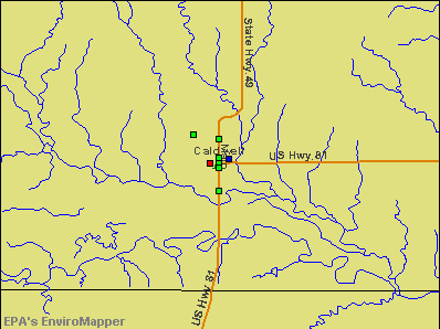
Notable locations in Caldwell: Sumner County Fairgrounds (A), Caldwell Police Department (B), Caldwell Public Library (C), Cherokee Strip Center (D), Border Queen Museum (E), Caldwell Fire Department (F). Display/hide their locations on the map
Churches in Caldwell include: Assembly of God Church (A), Central Christian Church (B), First Baptist Church (C), First Church of God (D), First Presbyterian Church (E), Saint Martin's Catholic Church (F), Soveriegn Grace Baptist Church (G), Caldwell United Methodist Church (H). Display/hide their locations on the map
Birthplace of: Max Showalter - Actor, Lee A. Johnson - Politician.
Sumner County has a predicted average indoor radon screening level between 2 and 4 pCi/L (pico curies per liter) - Moderate Potential
Drinking water stations with addresses in Caldwell that have no violations reported:
CALDWELL, CITY OF (Population served: 1,052,Primary Water Source Type: Groundwater)
Average household size:
This city:
2.1 people
Kansas:
2.5 people
Percentage of family households:
This city:
56.0%
Whole state:
66.0%
Percentage of households with unmarried partners:
This city:
6.9%
Whole state:
5.8%
Likely homosexual households (counted as self-reported same-sex unmarried-partner households)
Lesbian couples: 0.2% of all households
Gay men: 0.4% of all households
8 people in nursing facilities/skilled-nursing facilities in 2010
People in group quarters in Caldwell in 2000:
39 people in nursing homes
10 people in other noninstitutional group quarters
8 people in wards in general hospitals for patients who have no usual home elsewhere
Banks with branches in Caldwell (2011 data):
The Caldwell State Bank in Caldwell, Kansas: The Caldwell State Bank In Caldwell, Kansas at 24 North Main Street, branch established on 1928/04/03. Info updated 2006/11/03: Bank assets: $39.6 mil, Deposits: $33.8 mil, local headquarters, positive income, Agricultural Specialization, 1 total offices
The Stock Exchange Bank, Caldwell, Kansas: at 103 South Main Street, branch established on 1881/11/12. Info updated 2006/11/03: Bank assets: $41.0 mil, Deposits: $37.4 mil, local headquarters, positive income, Agricultural Specialization, 2 total offices, Holding Company: Stock Exchange Financial Corporation
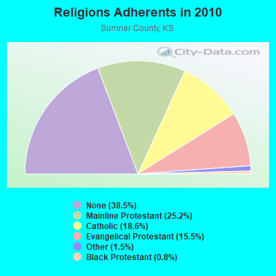
Religion statistics for Caldwell, KS (based on Sumner County data)
Religion
Adherents
Congregations
Mainline Protestant
6,073
28
Catholic
4,500
4
Evangelical Protestant
3,731
28
Other
350
2
Black Protestant
187
1
None
9,291
-
Source: Clifford Grammich, Kirk Hadaway, Richard Houseal, Dale E.Jones, Alexei Krindatch, Richie Stanley and Richard H.Taylor. 2012. 2010 U.S.Religion Census: Religious Congregations & Membership Study. Association of Statisticians of American Religious Bodies. Jones, Dale E., et al. 2002. Congregations and Membership in the United States 2000. Nashville, TN: Glenmary Research Center. Graphs represent county-level data
600 S Osage (Lat: 37.033361 Lon: -97.614222), Call Sign: KMB251, Assigned Frequencies: 155.220 MHz, Grant Date: 08/05/1997, Expiration Date: 09/18/2002, Cancellation Date: 01/12/2003, Registrant: Hospital District 1, 600 S Osage, Caldwell, KS 67022, Phone: (316) 845-6492
503 N Main (Lat: 37.040306 Lon: -97.608667), Call Sign: KNFT487, Licensee ID: L00115127, Assigned Frequencies: 151.865 MHz, Grant Date: 04/29/1997, Expiration Date: 06/22/2002, Cancellation Date: 10/27/2002, Registrant: Willis Kerr, 503 N Main, Caldwell, KS 67022, Phone: (316) 845-2441
1/4 Mi W Of Caldwell Airport (Lat: 37.033361 Lon: -97.583667), Call Sign: KNGH816, Assigned Frequencies: 152.990 MHz, Grant Date: 02/12/1998, Expiration Date: 04/06/2003, Cancellation Date: 10/08/2002, Registrant: John Cobb, Box 33, Caldwell, KS 67022
201 S Arrapohoe (Lat: 37.029750 Lon: -97.605056), Type: Pole, Structure height: 21 m, Call Sign: KAG700, Assigned Frequencies: 153.530 MHz, Grant Date: 08/17/2011, Expiration Date: 10/29/2021, Cancellation Date: 01/01/2022, Certifier: William Branch, Registrant: Sunflower Electric Power Corporation, 2075 W. St. John Street, Garden City, KS 67846, Phone: (620) 272-5400, Email:
14 West Central (Lat: 37.032611 Lon: -97.607667), Type: Tower, Structure height: 6.1 m, Overall height: 18.2 m, Call Sign: WPSQ547, Assigned Frequencies: 163.250 MHz, Grant Date: 04/27/2021, Expiration Date: 07/11/2031, Certifier: James A Reed, Registrant: Business Radio Licensing, 30251 Golden Lantern, Suite E # 501, Laguna Niguel, CA 92677, Phone: (949) 348-8510, Fax: (949) 348-8514, Email:
CALDWELL DTMF SWCH, Lat: 37.032361 Lon: -97.604306, Call Sign: WQPV516, Assigned Frequencies: 160.470 MHz, 160.470 MHz, Grant Date: 07/16/2022, Expiration Date: 08/23/2032, Certifier: Thomas J Mcgovern, Registrant: Concentrix, 222 So 15th St Suite 505n, Omaha, NE 68102, Phone: (402) 522-5068, Email:
BPS 1, Bps 1 - W Of W 160th St S & S Sumner Rd Junction (Lat: 37.055000 Lon: -97.566389), Type: Bant, Structure height: 6.1 m, Call Sign: WQSX444, Assigned Frequencies: 451.025 MHz, Grant Date: 12/04/2013, Expiration Date: 12/04/2023, Cancellation Date: 02/03/2024, Certifier: Alice Anderson-Stiles, Registrant: Micro-Comm, Inc., 15895 S. Pflumm Road, Olathe, KS 66062, Phone: (913) 390-4500, Fax: (913) 390-4550, Email:
FCC Registered Microwave Towers:
6
CALDWELL, Off Of South Springfield Road, 0.8 Km Nnw Of (Lat: 37.048861 Lon: -97.619806), Type: Gtower, Structure height: 83.8 m, Call Sign: WQEY378, Assigned Frequencies: 11265.0 MHz, 6555.00 MHz, 11265.0 MHz, 6555.00 MHz, 11265.0 MHz, 6555.00 MHz, 11265.0 MHz, 6555.00 MHz, 11345.0 MHz, 6555.00 MHz... (+14 more), Grant Date: 04/19/2016, Expiration Date: 05/17/2026, Cancellation Date: 11/21/2023, Certifier: Richard A Ruhl, Registrant: Lukas, Lafuria, Gutierrez & Sachs, LLP, 8350 Broad Street Suite 1450, Tysons, VA 22102, Phone: (703) 584-8673, Fax: (703) 584-8696, Email:
Caldwell Warehouse, 201 S Arapahoe St (Lat: 37.030167 Lon: -97.604667), Type: Pole, Structure height: 21 m, Call Sign: WQUU824, Assigned Frequencies: 17845.0 MHz, 17845.0 MHz, 17845.0 MHz, 17845.0 MHz, 17845.0 MHz, 17845.0 MHz, Grant Date: 10/20/2014, Expiration Date: 10/20/2024, Certifier: Jevin P Kasselman, Registrant: Wheatland Electric Cooperative, Inc, 416 S Main St, Scott City, KS 67871, Phone: (620) 872-5885, Fax: (620) 872-8786, Email:
Caldwell Sub, Se4 Of S35 T34s R3w (Lat: 37.040806 Lon: -97.603417), Type: Ltower, Structure height: 48.8 m, Call Sign: WQUV468, Assigned Frequencies: 11225.0 MHz, 19405.0 MHz, 11225.0 MHz, 19405.0 MHz, 11225.0 MHz, 19405.0 MHz, 11225.0 MHz, 19405.0 MHz, 11225.0 MHz, 19405.0 MHz, 11225.0 MHz, 19405.0 MHz, Grant Date: 10/23/2014, Expiration Date: 10/23/2024, Certifier: Jevin P Kasselman, Registrant: Wheatland Electric Cooperative, Inc, 416 S Main St, Scott City, KS 67871, Phone: (620) 872-5885, Fax: (620) 872-8786, Email:
CALDWELL DT, South Side Of The Town Of (Lat: 37.024889 Lon: -97.606028), Type: Mtower, Structure height: 45.7 m, Overall height: 50.3 m, Call Sign: WRDD380, Assigned Frequencies: 10775.0 MHz, 10775.0 MHz, 10775.0 MHz, 10775.0 MHz, 10855.0 MHz, 10855.0 MHz, 10855.0 MHz, 10855.0 MHz, Grant Date: 04/02/2019, Expiration Date: 04/02/2029, Cancellation Date: 11/21/2023, Certifier: Steve Espolt, Registrant: Lukas, Lafuria, Gutierrez & Sachs, LLP, 8350 Broad Street Suite 1450, Tysons, VA 22102, Phone: (703) 584-8673, Fax: (703) 584-8696, Email:
CORBIN, 1155 W 90th Street (Ks11384-A) (Lat: 37.154667 Lon: -97.666361), Type: Gtower, Structure height: 79.2 m, Overall height: 80.5 m, Call Sign: WRDD381, Licensee ID: L00085110, Assigned Frequencies: 10735.0 MHz, 10735.0 MHz, 10735.0 MHz, 10735.0 MHz, 10735.0 MHz, 10735.0 MHz, 10735.0 MHz, 10735.0 MHz, 10815.0 MHz, 10815.0 MHz... (+6 more), Grant Date: 04/02/2019, Expiration Date: 04/02/2029, Cancellation Date: 04/26/2021, Certifier: Steve Espolt, Registrant: Cellular Network Partnership, An Ok LP, Kingfisher, OK 73750, Phone: (405) 375-0330, Email:
CORBIN II, 97yds East Of S Ryan Rd And 938yds South Of W 90th Street S (Lat: 37.147528 Lon: -97.655417), Type: Gtower, Structure height: 86.9 m, Overall height: 89.9 m, Call Sign: WRMI246, Assigned Frequencies: 10735.0 MHz, 10735.0 MHz, 10735.0 MHz, 10735.0 MHz, 10735.0 MHz, 10735.0 MHz, 10735.0 MHz, 10735.0 MHz, 10815.0 MHz, 10815.0 MHz... (+6 more), Grant Date: 04/13/2021, Expiration Date: 04/13/2031, Cancellation Date: 11/21/2023, Certifier: Richard Ruhl, Registrant: Lukas, Lafuria, Gutierrez & Sachs, LLP, 8350 Broad Street Suite 1450, Tysons, VA 22102, Phone: (703) 584-8673, Fax: (703) 584-8696, Email:
Aircraft: AERONCA 65-CA (Category: Land, Seats: 2, Weight: Up to 12,499 Pounds, Speed: 75 mph), Engine: CONT MOTOR A&C65 SERIES (65 HP) (Reciprocating) N-Number: 29445, N29445, N-29445, Serial Number: C-10300, Year manufactured: 1940, Airworthiness Date: 08/09/1955, Certificate Issue Date: 09/23/2019 Registrant (Individual): Michael E Brunhoeber, 1172 S Springdale Rd, Caldwell, KS 67022
Aircraft: PIPER PA-28-160 (Category: Land, Seats: 4, Weight: Up to 12,499 Pounds, Speed: 107 mph), Engine: LYCOMING 0-320 SERIES (180 HP) (Reciprocating) N-Number: 5265W, N5265W, N-5265W, Serial Number: 28-311, Year manufactured: 1962, Airworthiness Date: 01/24/1962, Certificate Issue Date: 11/04/1988 Registrant (Corporation): Dwight Marketing Corporation, 431 W 160th St S, Caldwell, KS 67022
2003 - 2018 National Fire Incident Reporting System (NFIRS) incidents
According to the data from the years 2003 - 2018 the average number of fire incidents per year is 28. The highest number of fire incidents - 56 took place in 2006, and the least - 11 in 2010. The data has a dropping trend.
When looking into fire subcategories, the most reports belonged to: Outside Fires (65.1%), and Structure Fires (16.8%).
Fire incident types reported to NFIRS in Caldwell, KS
#66 on the list of "Top 101 cities with the largest percentage of people in wards in general hospitals for patients who have no usual home elsewhere (population 1,000+)"
#27 on the list of "Top 101 counties with the highest Nitrogen Dioxide air pollution readings in 2012 (ppm)"


 Recent articles from our blog. Our writers, many of them Ph.D. graduates or candidates, create easy-to-read articles on a wide variety of topics.

 (47.7 miles


 According to the data from the years 2003 - 2018 the average number of fire incidents per year is 28. The highest number of fire incidents - 56 took place in 2006, and the least - 11 in 2010. The data has a dropping trend.
 When looking into fire subcategories, the most reports belonged to: Outside Fires (65.1%), and Structure Fires (16.8%).
