Burnham, New Mexico
Submit your own pictures of this place and show them to the world
- OSM Map
- General Map
- Google Map
- MSN Map

| Males: 2,594 | |
| Females: 2,583 |
| Median resident age: | 23.6 years |
| New Mexico median age: | 34.6 years |
Zip code: 87416
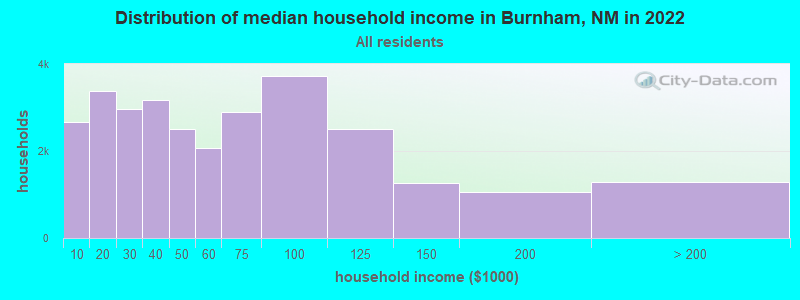
| Burnham: | $35,689 |
| NM: | $59,726 |
Estimated per capita income in 2022: $12,634 (it was $7,173 in 2000)
Burnham CCD income, earnings, and wages data
Estimated median house or condo value in 2022: $82,409 (it was $34,300 in 2000)
| Burnham: | $82,409 |
| NM: | $243,100 |
Mean prices in 2022: all housing units: $214,182; detached houses: $258,708; townhouses or other attached units: $238,387; mobile homes: $127,007; occupied boats, rvs, vans, etc.: $48,750
Detailed information about poverty and poor residents in Burnham, NM
Compare current foreclosures near Burnham, NM:
| Photo | Address | Area | Beds / Baths | Price | Details |
|---|---|---|---|---|---|

|
#1
County Rd 6897
Waterflow, NM 87421
|
1,067 sq. feet
|
2 baths 3 beds |
show details | |

|
#2
Road 6400
Kirtland, NM 87417
|
- sq. feet
|
- baths - beds |
show details | |

|
#3
Ostrich St
Farmington, NM 87401
|
- sq. feet
|
- baths - beds |
show details | |

|
#4
W 24th St
Farmington, NM 87401
|
- sq. feet
|
- baths - beds |
show details | |

|
#5
El Paso Dr
Farmington, NM 87401
|
- sq. feet
|
- baths - beds |
show details | |

|
#6
Chilton Ct
Farmington, NM 87401
|
- sq. feet
|
- baths - beds |
show details | |

|
#7
Finch Ave
Farmington, NM 87401
|
- sq. feet
|
- baths - beds |
show details | |

|
#8
La Sierra Pl
Farmington, NM 87401
|
- sq. feet
|
- baths - beds |
show details | |

|
#9
Winter Park
Farmington, NM 87401
|
- sq. feet
|
- baths - beds |
show details | |

|
#10
Mockingbird Cir
Farmington, NM 87401
|
- sq. feet
|
- baths - beds |
show details |
| Photo | Address | Area | Beds / Baths | Price | Details |
|---|---|---|---|---|---|

|
#11
Road 6663
Fruitland, NM 87416
|
- sq. feet
|
- baths - beds |
show details | |

|
#12
Brenna Pl
Farmington, NM 87401
|
- sq. feet
|
- baths - beds |
show details | |

|
#13
N Monterey Ave
Farmington, NM 87401
|
- sq. feet
|
- baths - beds |
show details | |

|
#14
Brooke Pl
Farmington, NM 87401
|
- sq. feet
|
- baths - beds |
show details | |

|
#15
N Western Ave
Farmington, NM 87401
|
- sq. feet
|
- baths - beds |
show details | |

|
#16
Lynwood Dr
Farmington, NM 87401
|
- sq. feet
|
- baths - beds |
show details | |

|
#17
Road 6406 # A
Kirtland, NM 87417
|
- sq. feet
|
- baths - beds |
show details | |

|
#18
W 31st St
Farmington, NM 87401
|
- sq. feet
|
- baths - beds |
show details | |

|
#19
Ocio St
Farmington, NM 87401
|
- sq. feet
|
- baths - beds |
show details | |

|
#20
N Chaco Ave
Farmington, NM 87401
|
- sq. feet
|
- baths - beds |
show details |
| Photo | Address | Area | Beds / Baths | Price | Details |
|---|---|---|---|---|---|

|
Check over 1 million property listings on Foreclosure.com!
|
browse all offers | |||
| Photo | Address | Area | Beds / Baths | Price | Details |
|---|

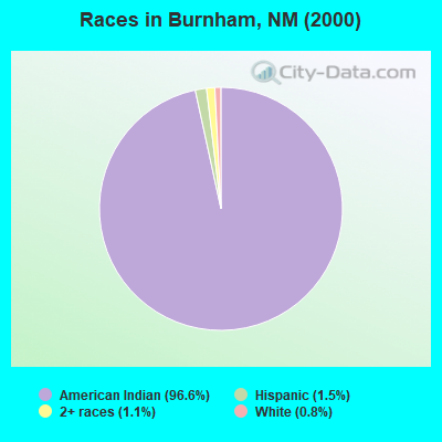
- 4,66696.6%American Indian alone
- 711.5%Hispanic
- 511.1%Two or more races
- 370.8%White alone
- 10.02%Black alone
- 10.02%Asian alone
- 10.02%Native Hawaiian and Other
Pacific Islander alone
Races in Burnham detailed stats: ancestries, foreign born residents, place of birth
 Recent articles from our blog. Our writers, many of them Ph.D. graduates or candidates, create easy-to-read articles on a wide variety of topics.

Current Local Time: MST time zone
Land area: 623.1 square miles.
Population density: 8.3 people per square mile (very low).

| Burnham CCD: | 0.7% ($251) |
| New Mexico: | 0.7% ($699) |
Nearest city with pop. 50,000+: Rio Rancho, NM  (130.6 miles , pop. 51,765).
Nearest city with pop. 200,000+: Albuquerque, NM (141.5 miles , pop. 448,607).
Nearest city with pop. 1,000,000+: Phoenix, AZ (295.6 miles , pop. 1,321,045).
Nearest cities:
), ), ), ), ), ), Latitude: 36.56 N, Longitude: 108.39 W
Area code commonly used in this area: 505

| Here: | 3.9% |
| New Mexico: | 3.6% |
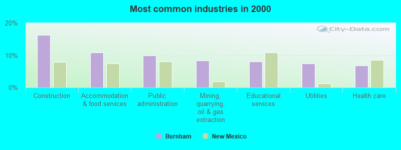
- Construction (16.3%)
- Accommodation & food services (10.8%)
- Public administration (9.9%)
- Mining, quarrying, oil & gas extraction (8.3%)
- Educational services (8.0%)
- Utilities (7.4%)
- Health care (6.9%)
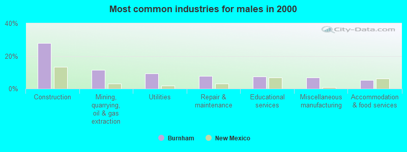
- Construction (27.9%)
- Mining, quarrying, oil & gas extraction (11.5%)
- Utilities (9.3%)
- Repair & maintenance (7.6%)
- Educational services (7.5%)
- Miscellaneous manufacturing (6.9%)
- Accommodation & food services (5.4%)
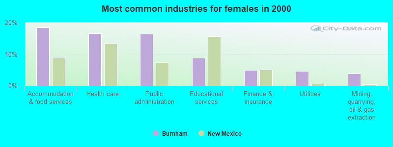
- Accommodation & food services (18.4%)
- Health care (16.6%)
- Public administration (16.4%)
- Educational services (8.8%)
- Finance & insurance (5.0%)
- Utilities (4.6%)
- Mining, quarrying, oil & gas extraction (3.8%)
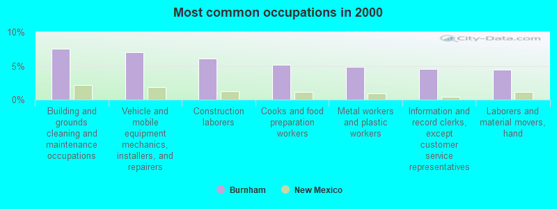
- Building and grounds cleaning and maintenance occupations (7.6%)
- Vehicle and mobile equipment mechanics, installers, and repairers (7.0%)
- Construction laborers (6.1%)
- Cooks and food preparation workers (5.1%)
- Metal workers and plastic workers (4.8%)
- Information and record clerks, except customer service representatives (4.6%)
- Laborers and material movers, hand (4.5%)
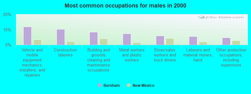
- Vehicle and mobile equipment mechanics, installers, and repairers (11.9%)
- Construction laborers (10.3%)
- Building and grounds cleaning and maintenance occupations (8.4%)
- Metal workers and plastic workers (7.4%)
- Driver/sales workers and truck drivers (5.9%)
- Laborers and material movers, hand (5.7%)
- Other production occupations, including supervisors (4.7%)
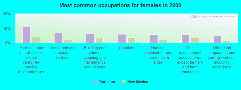
- Information and record clerks, except customer service representatives (11.0%)
- Cooks and food preparation workers (6.8%)
- Building and grounds cleaning and maintenance occupations (6.4%)
- Cashiers (6.0%)
- Nursing, psychiatric, and home health aides (5.8%)
- Other management occupations, except farmers and farm managers (5.6%)
- Other food preparation and serving workers, including supervisors (4.8%)
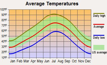
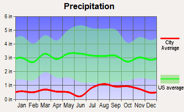
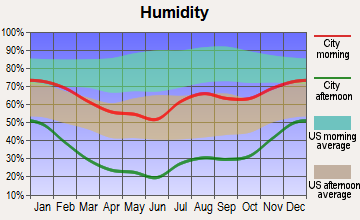
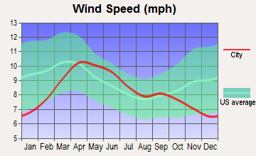
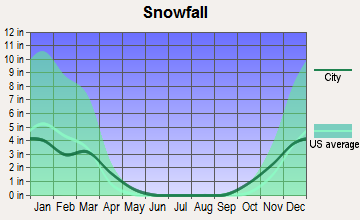
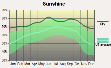
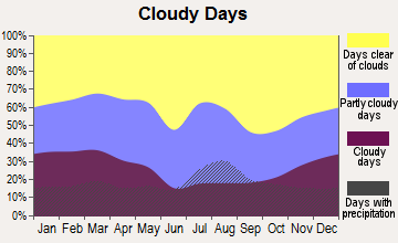
Average climate in Burnham, New Mexico
Based on data reported by over 4,000 weather stations
(lower is better)
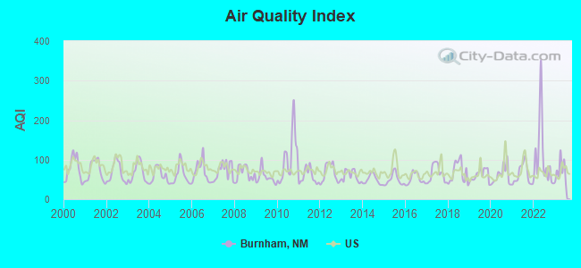
Air Quality Index (AQI) level in 2023 was 71.9. This is about average.
| City: | 71.9 |
| U.S.: | 72.6 |
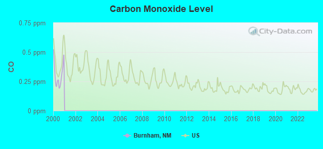
Carbon Monoxide (CO) [ppm] level in 2000 was 0.308. This is worse than average. Closest monitor was 15.1 miles away from the city center.
| City: | 0.308 |
| U.S.: | 0.251 |
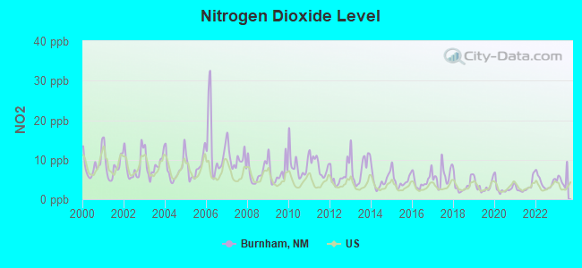
Nitrogen Dioxide (NO2) [ppb] level in 2023 was 5.19. This is about average. Closest monitor was 11.9 miles away from the city center.
| City: | 5.19 |
| U.S.: | 5.11 |
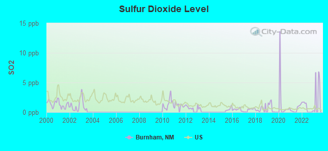
Sulfur Dioxide (SO2) [ppb] level in 2022 was 0.735. This is significantly better than average. Closest monitor was 11.9 miles away from the city center.
| City: | 0.735 |
| U.S.: | 1.515 |
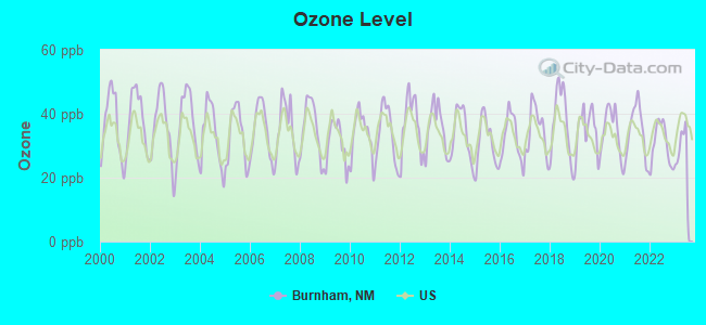
Ozone [ppb] level in 2023 was 27.2. This is better than average. Closest monitor was 17.1 miles away from the city center.
| City: | 27.2 |
| U.S.: | 33.3 |

Particulate Matter (PM10) [µg/m3] level in 2022 was 20.7. This is about average. Closest monitor was 15.1 miles away from the city center.
| City: | 20.7 |
| U.S.: | 19.2 |
Earthquake activity:
Burnham-area historical earthquake activity is significantly above New Mexico state average. It is 1299% greater than the overall U.S. average.On 6/28/1992 at 11:57:34, a magnitude 7.6 (6.2 MB, 7.6 MS, 7.3 MW, Depth: 0.7 mi, Class: Major, Intensity: VIII - XII) earthquake occurred 487.3 miles away from the city center, causing 3 deaths (1 shaking deaths, 2 other deaths) and 400 injuries, causing $100,000,000 total damage and $40,000,000 insured losses
On 10/16/1999 at 09:46:44, a magnitude 7.4 (6.3 MB, 7.4 MS, 7.2 MW, 7.3 ML) earthquake occurred 473.9 miles away from the city center
On 5/19/1940 at 04:36:40, a magnitude 7.2 (7.2 UK) earthquake occurred 474.0 miles away from the city center, causing $33,000,000 total damage
On 8/18/1959 at 06:37:13, a magnitude 7.7 (7.7 UK) earthquake occurred 566.4 miles away from the city center, causing $26,000,000 total damage
On 10/3/1915 at 06:52:48, a magnitude 7.6 (7.6 UK) earthquake occurred 562.7 miles away from Burnham center
On 9/2/1992 at 10:26:20, a magnitude 5.9 (5.7 MB, 5.6 MS, 5.6 MW, 5.9 ML, Depth: 9.3 mi, Class: Moderate, Intensity: VI - VII) earthquake occurred 283.0 miles away from Burnham center
Magnitude types: body-wave magnitude (MB), local magnitude (ML), surface-wave magnitude (MS), moment magnitude (MW)
Natural disasters:
The number of natural disasters in San Juan County (9) is smaller than the US average (15).Major Disasters (Presidential) Declared: 4
Emergencies Declared: 3
Causes of natural disasters: Floods: 3, Storms: 3, Fires: 2, Drought: 1, Hurricane: 1, Mudslide: 1, Other: 2 (Note: some incidents may be assigned to more than one category).
Hospitals and medical centers near Burnham:
- SUN CREST HOSPITAL (Hospital, about 15 miles away; FARMINGTON, NM)
- LIFE CARE CENTER OF FARMINGTON (Nursing Home, about 15 miles away; FARMINGTON, NM)
- SAN JUAN CARE AND REHABILITATION CENTER (Nursing Home, about 16 miles away; FARMINGTON, NM)
- SAN JUAN MANOR NF (Nursing Home, about 16 miles away; FARMINGTON, NM)
- SAN JUAN REGIONAL MEDICAL CENTER Acute Care Hospitals (about 16 miles away; FARMINGTON, NM)
- SAN JUAN REGIONAL REHABILITATION HOSPITAL (Hospital, about 16 miles away; FARMINGTON, NM)
- FOUR CORNERS DIALYSIS FARMINGTON (DVA) (Dialysis Facility, about 16 miles away; FARMINGTON, NM)
Colleges/universities with over 2000 students nearest to Burnham:
- San Juan College (about 20 miles; Farmington, NM; Full-time enrollment: 5,112)
- Fort Lewis College (about 58 miles; Durango, CO; FT enrollment: 3,631)
- University of Phoenix-Albuquerque Campus (about 139 miles; Albuquerque, NM; FT enrollment: 2,335)
- University of New Mexico-Main Campus (about 143 miles; Albuquerque, NM; FT enrollment: 23,042)
- Central New Mexico Community College (about 143 miles; Albuquerque, NM; FT enrollment: 19,398)
- Santa Fe Community College (about 150 miles; Santa Fe, NM; FT enrollment: 3,047)
- Adams State University (about 153 miles; Alamosa, CO; FT enrollment: 2,805)
Points of interest:
Notable locations in Burnham: Four Corners Powerplant (A), Burnham Trading Post (B), Nenahnezad Chapter House (C). Display/hide their locations on the map
Church in Burnham: Saint Michael Church (A). Display/hide its location on the map
Reservoir: Morgan Lake (A). Display/hide its location on the map
Streams, rivers, and creeks: De-na-zin Wash (A), Rio Chusca (B), Coal Creek (C), Pinabete Arroyo (D), Sheep Springs Wash (E), Teec-ni-di-tso Wash (F), Chinde Wash (G), Coyote Wash (H), Hunter Wash (I). Display/hide their locations on the map
| This place: | 3.9 people |
| New Mexico: | 2.6 people |
| This place: | 64.5% |
| Whole state: | 69.2% |
| This place: | 6.9% |
| Whole state: | 6.4% |
Likely homosexual households (counted as self-reported same-sex unmarried-partner households)
- Lesbian couples: 0.2% of all households
- Gay men: 0.2% of all households
| This place: | 37.6% |
| Whole state: | 18.4% |
| This place: | 10.7% |
| Whole state: | 7.8% |
For population 15 years and over in Burnham:
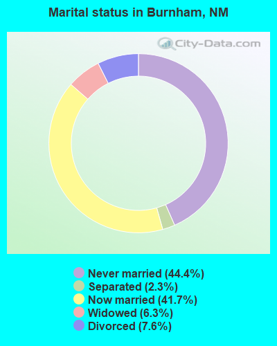
- Never married: 44.4%
- Now married: 41.7%
- Separated: 2.3%
- Widowed: 6.3%
- Divorced: 7.6%
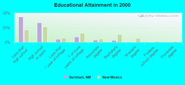
For population 25 years and over in Burnham:
- High school or higher: 56.1%
- Bachelor's degree or higher: 4.2%
- Graduate or professional degree: 0.8%
- Unemployed: 20.9%
- Mean travel time to work (commute): 30.5 minutes
| Here: | 18.2 |
| New Mexico average: | 14.5 |
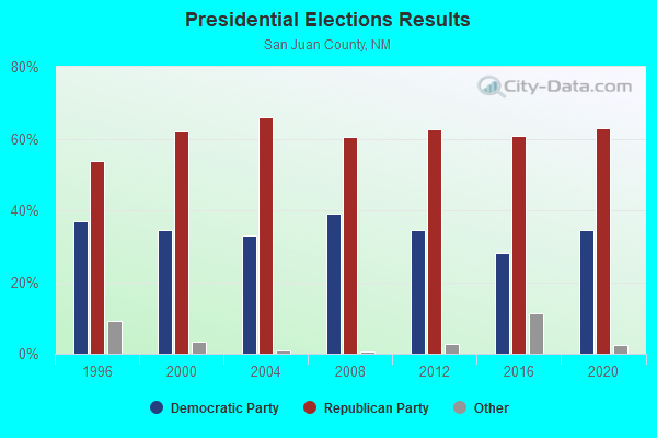
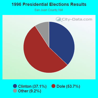

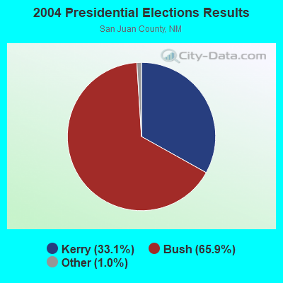
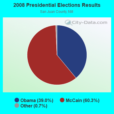
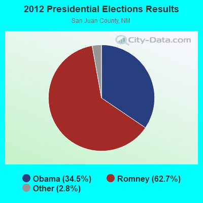
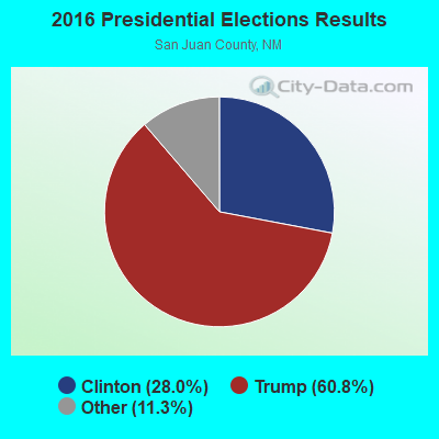

Graphs represent county-level data. Detailed 2008 Election Results
Religion statistics for Burnham, NM (based on San Juan County data)
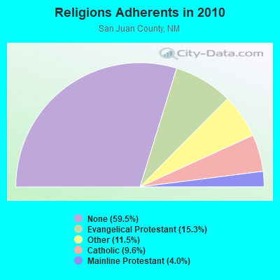
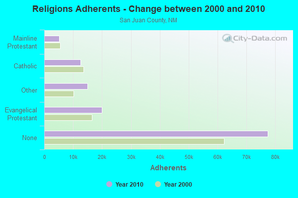
| Religion | Adherents | Congregations |
|---|---|---|
| Evangelical Protestant | 19,905 | 115 |
| Other | 15,001 | 31 |
| Catholic | 12,500 | 11 |
| Mainline Protestant | 5,222 | 16 |
| None | 77,416 | - |
Food Environment Statistics:
| This county: | 0.82 / 10,000 pop. |
| New Mexico: | 1.44 / 10,000 pop. |
| This county: | 0.16 / 10,000 pop. |
| New Mexico: | 0.21 / 10,000 pop. |
| This county: | 0.41 / 10,000 pop. |
| New Mexico: | 0.32 / 10,000 pop. |
| Here: | 5.73 / 10,000 pop. |
| State: | 4.06 / 10,000 pop. |
| Here: | 5.07 / 10,000 pop. |
| New Mexico: | 7.12 / 10,000 pop. |
| San Juan County: | 7.3% |
| State: | 6.4% |
| San Juan County: | 26.4% |
| New Mexico: | 22.1% |
Strongest AM radio stations in Burnham:
- KENN (1390 AM; 10 kW; FARMINGTON, NM; Owner: WINTON ROAD BROADCASTING CO, LLC)
- KNDN (960 AM; 5 kW; FARMINGTON, NM; Owner: BASIN BROADCASTING CO.)
- KTNN (660 AM; 50 kW; WINDOW ROCK, AZ; Owner: THE NAVAJO NATION)
- KHAC (880 AM; 43 kW; TSE BONITO, NM; Owner: WESTERN INDIAN MINISTRIES, INC.)
- KRZE (1280 AM; 5 kW; FARMINGTON, NM; Owner: J. THOMAS DEVELOPMENT OF NM, INC.)
- KKOB (770 AM; 50 kW; ALBUQUERQUE, NM; Owner: CITADEL BROADCASTING COMPANY)
- KNZZ (1100 AM; 50 kW; GRAND JUNCTION, CO; Owner: M B C GRAND BROADCASTING, INC.)
- KIUP (930 AM; 5 kW; DURANGO, CO; Owner: FOUR CORNERS BROADCASTING, LLC)
- KLLV (550 AM; daytime; 2 kW; BREEN, CO; Owner: DAYSTAR RADIO, LTD.)
- KCQL (1340 AM; 1 kW; AZTEC, NM; Owner: CAPSTAR TX LIMITED PARTNERSHIP)
- KMIA (710 AM; 50 kW; BLACK CANYON CITY, AZ; Owner: ENTRAVISION HOLDINGS, LLC)
- KLTT (670 AM; 50 kW; COMMERCE CITY, CO; Owner: KLZ RADIO, INC.)
- KGAK (1330 AM; 5 kW; GALLUP, NM; Owner: KRJG, INC.)
Strongest FM radio stations in Burnham:
- KNMI (88.9 FM; FARMINGTON, NM; Owner: NAVAJO MISSIONS, INC.)
- K287AC (105.3 FM; FARMINGTON, NM; Owner: KUTE, INC.)
- KISZ-FM1 (97.9 FM; FARMINGTON, NM; Owner: WINTON ROAD BROADCASTING CO, LLC)
- K230AF (93.9 FM; KIRTLAND, NM; Owner: CAPSTAR TX LIMITED PARTNERSHIP)
- KRTZ (98.7 FM; CORTEZ, CO; Owner: WINTON ROAD BROADCASTING CO., LLC)
- KWYK-FM (94.9 FM; AZTEC, NM; Owner: BASIN BROADCASTING COMPANY)
- K289AD (105.7 FM; CHINLE, AZ; Owner: PROCLAIMING CHRIST'S LOVE MINISTRIES)
- KRWN (92.9 FM; FARMINGTON, NM; Owner: WINTON ROAD BROADCASTING CO, LLC)
- KPCL (95.7 FM; FARMINGTON, NM; Owner: VOICE MINISTRIES OF FARMINGTON)
- KSJE (90.9 FM; FARMINGTON, NM; Owner: SAN JUAN COLLEGE)
- KDAG (96.9 FM; FARMINGTON, NM; Owner: CAPSTAR TX LIMITED PARTNERSHIP)
- K232DA (94.3 FM; HESPERUS, CO; Owner: NATIVE AMERICAN CHRISTIAN VOICE, INC.)
- K237CR (95.3 FM; HESPERUS, CO; Owner: NATIVE AMERICAN CHRISTIAN VOICE, INC.)
- KKFG (104.5 FM; BLOOMFIELD, NM; Owner: CAPSTAR TX LIMITED PARTNERSHIP)
- KTGW (91.7 FM; FRUITLAND, NM; Owner: NATIVE AMERICAN CHRISTIAN VOICE, INC)
- KAZX (102.9 FM; KIRTLAND, NM; Owner: CAPSTAR TX LIMITED PARTNERSHIP)
- KTRA-FM (102.1 FM; FARMINGTON, NM; Owner: CAPSTAR TX LIMITED PARTNERSHIP)
- K257DQ (99.3 FM; FARMINGTON, NM; Owner: BEN F. STINSON III)
- K220EM (91.9 FM; DZILTH-NA-O-DITH-HLE, NM; Owner: THE REGENTS OF THE UNIV. OF N.M.)
TV broadcast stations around Burnham:
- K08HQ (Channel 8; CHINLE, AZ; Owner: KOB-TV, LLC)
- K23BT (Channel 23; FARMINGTON, NM; Owner: ACME TELEVISION LICENSES OF NEW MEXICO, LLC)
- K47DR (Channel 47; FARMINGTON, NM; Owner: CHRISTIAN B/CING COMMUNICATIONS)
- K21AX (Channel 21; FARMINGTON, NM; Owner: EMMIS TELEVISION LICENSE CORPORATION)
- K43AI (Channel 43; FARMINGTON, NM; Owner: REGENTS OF THE UNIVERSITY OF NEW MEXICO)
- K19CM (Channel 19; FARMINGTON, NM; Owner: KOAT HEARST-ARGYLE TELEVISION, INC.)
- KOBF (Channel 12; FARMINGTON, NM; Owner: KOB-TV, LLC)
FCC Registered Antenna Towers:
4- Renee Chappell, 15 Mi E. Of Hwy 191 And 1500 Ft S Of Bia Rd. 5 (Lat: 36.331778 Lon: -108.441528), Type: 58.0, Overall height: 58 m, Registrant: Smith Bagley, Inc. Dba Cellularone, Rchappell@cellularoneaz.Com, , Show -Low, Phone: (928) 537-0690
- Renee Chappell, 15 Mi E. Of Hwy 191 And 1500 Ft S Of Bia Rd. 5 (Lat: 36.331778 Lon: -108.441528), Type: 58.0, Overall height: 58 m, Registrant: Smith Bagley, Inc. Dba Cellularone, Rchappell@cellularoneaz.Com, , Show -Low, Phone: (928) 537-0690
- Gwen Sherwood, 15 Mi E. Of Hwy 191 And 1500 Ft S Of Bia Rd. 5 (Lat: 36.331778 Lon: -108.441528), Type: 58.0, Structure height: 35045 m, Overall height: 58 m, Registrant: Smith Bagley, Inc., Gpine@cellularoneaz.Com, , Show -Low, Phone: (928) 537-0375
- Ella McNeil, 15 Mi E. Of Hwy 191 And 1500 Ft S Of Bia Rd. 5 (Lat: 36.331778 Lon: -108.441528), Type: 58.0, Structure height: 35045 m, Overall height: 58 m, Registrant: Smith Bagley Inc, Emcneil@cellularoneaz.Com, , Show -Low, Phone: (928) 537-0690
FCC Registered Microwave Towers:
1- BURNHAM, Burnham, Nm. Zip Code: 87325 (Lat: 36.335056 Lon: -108.432611), Type: Tower, Structure height: 54.9 m, Call Sign: WQLJ559,
Assigned Frequencies: 10755.0 MHz, 10795.0 MHz, 12950.0 MHz, 13000.0 MHz, 10835.0 MHz, 10875.0 MHz, Grant Date: 01/07/2020, Expiration Date: 02/12/2030, Certifier: Justin E Hinkle, Registrant: Americas Communications LLC, 6100 W Gila Springs Place, Ste 7, Chandler, AZ 85226, Phone: (602) 304-1760, Fax: (877) 284-0791, Email:
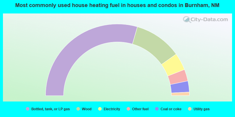
- 59.0%Bottled, tank, or LP gas
- 21.4%Wood
- 7.8%Electricity
- 5.3%Other fuel
- 5.0%Coal or coke
- 1.6%Utility gas
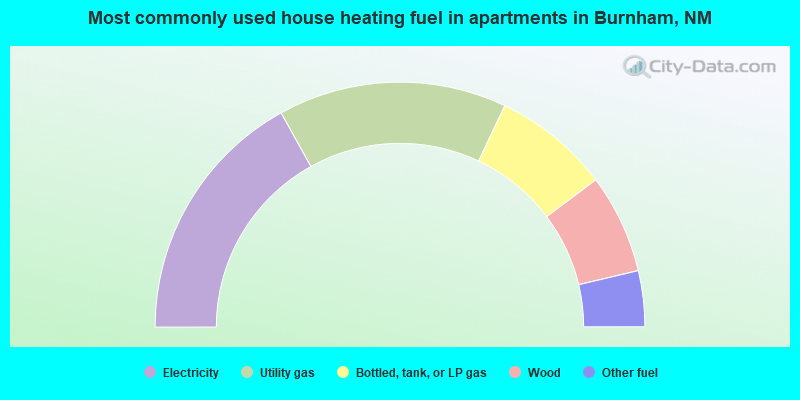
- 33.9%Electricity
- 30.2%Utility gas
- 15.4%Bottled, tank, or LP gas
- 13.1%Wood
- 7.4%Other fuel
Burnham compared to New Mexico state average:
- Median household income below state average.
- Median house value significantly below state average.
- Black race population percentage significantly below state average.
- Hispanic race population percentage significantly below state average.
- Median age significantly below state average.
- Foreign-born population percentage significantly below state average.
- Renting percentage significantly below state average.
- Length of stay since moving in significantly above state average.
- Number of rooms per house significantly below state average.
- House age significantly below state average.
- Percentage of population with a bachelor's degree or higher significantly below state average.
Burnham on our top lists:
- #1 on the list of "Top 101 cities with largest percentage of males in occupations: construction laborers (population 5,000+)"
- #2 on the list of "Top 101 cities with largest percentage of males in occupations: vehicle and mobile equipment mechanics, installers, and repairers (population 5,000+)"
- #3 on the list of "Top 101 cities with largest percentage of females in occupations: electrical equipment mechanics and other installation, maintenance, and repair occupations including supervisors (population 5,000+)"
- #3 on the list of "Top 101 cities with largest percentage of females in occupations: plant and system operators (population 5,000+)"
- #3 on the list of "Top 101 cities with largest percentage of males in industries: miscellaneous manufacturing (population 5,000+)"
- #4 on the list of "Top 101 cities with largest percentage of females in occupations: other food preparation and serving workers including supervisors (population 5,000+)"
- #5 on the list of "Top 101 cities with largest percentage of males in occupations: pipelayers, plumbers, pipefitters, and steamfitters (population 5,000+)"
- #7 on the list of "Top 101 cities with largest percentage of females in industries: pharmacies and drug stores (population 5,000+)"
- #7 on the list of "Top 101 cities with largest percentage of males in industries: repair and maintenance (population 5,000+)"
- #8 on the list of "Top 101 cities with largest percentage of males in industries: clothing and accessories, including shoe, stores (population 5,000+)"
- #10 on the list of "Top 101 cities with the largest house values disparities (population 5,000+)"
- #19 on the list of "Top 101 cities with largest percentage of females in industries: utilities (population 5,000+)"
- #24 on the list of "Top 101 cities with largest percentage of males in industries: utilities (population 5,000+)"
- #35 on the list of "Top 101 cities with the least people having Master's or Doctorate degrees (population 5,000+)"
- #36 on the list of "Top 101 cities with largest percentage of females in industries: wood products (population 5,000+)"
- #37 on the list of "Top 101 cities with the most people taking a taxi to work (population 5,000+)"
- #39 on the list of "Top 101 cities with largest percentage of females in industries: groceries and related products merchant wholesalers (population 5,000+)"
- #42 on the list of "Top 101 cities with largest percentage of females in industries: furniture and related product manufacturing (population 5,000+)"
- #52 on the list of "Top 101 cities with largest percentage of females in industries: mining, quarrying, and oil and gas extraction (population 5,000+)"
- #54 on the list of "Top 101 cities with largest percentage of males in industries: petroleum and petroleum products merchant wholesalers (population 5,000+)"
- #44 (87416) on the list of "Top 101 zip codes with the largest percentage of Dutch first ancestries"
- #80 (87416) on the list of "Top 101 zip codes with the smallest percentage of taxpayers reporting profit/loss from business in 2012 (pop 5,000+)"
- #3 on the list of "Top 101 counties with the largest number of people moving out compared to moving in (pop. 50,000+)"
- #13 on the list of "Top 101 counties with the lowest percentage of residents that visited a dentist within the past year"
- #16 on the list of "Top 101 counties with highest percentage of residents voting for 3rd party candidates in the 2012 Presidential Election (pop. 50,000+)"
- #21 on the list of "Top 101 counties with the lowest Particulate Matter (PM2.5) Annual air pollution readings in 2012 (µg/m3)"
- #25 on the list of "Top 101 counties with the highest percentage of residents that keep firearms around their homes"