Bryantsville, Kentucky
Submit your own pictures of this place and show them to the world
- OSM Map
- General Map
- Google Map
- MSN Map

| Males: 2,565 | |
| Females: 2,452 |
| Median resident age: | 36.0 years |
| Kentucky median age: | 35.9 years |
Zip code: 40444
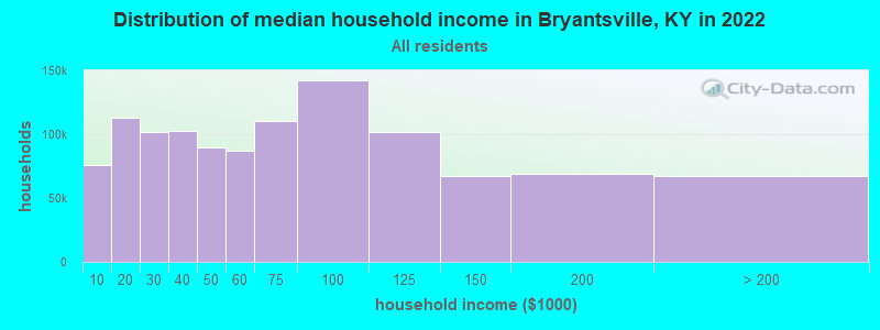
| Bryantsville: | $69,913 |
| KY: | $59,341 |
Estimated per capita income in 2022: $33,250 (it was $18,053 in 2000)
Bryantsville CCD income, earnings, and wages data
Estimated median house or condo value in 2022: $225,897 (it was $96,000 in 2000)
| Bryantsville: | $225,897 |
| KY: | $196,300 |
Mean prices in 2022: all housing units: $224,811; detached houses: $238,115; mobile homes: $84,167
Detailed information about poverty and poor residents in Bryantsville, KY
Compare current foreclosures near Bryantsville, KY:
| Photo | Address | Area | Beds / Baths | Price | Details |
|---|---|---|---|---|---|

|
#1
Pam Dr
Lancaster, KY 40444
|
1,417 sq. feet
|
2 baths 3 beds |
$170,000
|
show details |

|
#2
Richmond St
Lancaster, KY 40444
|
3,293 sq. feet
|
3 baths 4 beds |
$250,000
|
show details |

|
#3
Cottage St
Nicholasville, KY 40356
|
1 sq. feet
|
1 baths 1 beds |
$62,500
|
show details |

|
#4
Feathers Ln
Danville, KY 40422
|
1,003 sq. feet
|
1 baths 3 beds |
$54,500
|
show details |

|
#5
Baybrook Cir
Nicholasville, KY 40356
|
1,432 sq. feet
|
2 baths 3 beds |
show details | |

|
#6
Ridgecrest Dr
Nicholasville, KY 40356
|
1,560 sq. feet
|
2 baths 3 beds |
show details | |

|
#7
Cardinal Dr
Harrodsburg, KY 40330
|
1,218 sq. feet
|
1 baths 2 beds |
show details | |

|
#8
Runyon Rd
Harrodsburg, KY 40330
|
1,936 sq. feet
|
2 baths 3 beds |
show details | |

|
#9
Talmage Mayo Rd
Harrodsburg, KY 40330
|
1,352 sq. feet
|
1 baths 3 beds |
show details | |

|
#10
Tabler Ave
Harrodsburg, KY 40330
|
624 sq. feet
|
1 baths 2 beds |
show details |
| Photo | Address | Area | Beds / Baths | Price | Details |
|---|---|---|---|---|---|

|
#11
Allison Cir
Nicholasville, KY 40356
|
1,339 sq. feet
|
2 baths 3 beds |
show details | |

|
#12
Ridge Rd
Harrodsburg, KY 40330
|
1,000 sq. feet
|
1 baths 3 beds |
show details | |

|
#13
Beechmont Dr
Nicholasville, KY 40356
|
1,036 sq. feet
|
1 baths 3 beds |
show details | |

|
#14
Rolling Acres Dr
Nicholasville, KY 40356
|
1,080 sq. feet
|
1 baths 3 beds |
show details | |

|
#15
Liberty St
Nicholasville, KY 40356
|
1,066 sq. feet
|
1 baths 3 beds |
show details | |

|
#16
Kimberly Heights Dr
Nicholasville, KY 40356
|
1,512 sq. feet
|
2 baths 3 beds |
show details | |

|
#17
Greenbriar Dr
Harrodsburg, KY 40330
|
1,167 sq. feet
|
1 baths 2 beds |
show details | |

|
#18
Greenbriar Dr
Harrodsburg, KY 40330
|
1,134 sq. feet
|
1 baths 3 beds |
show details | |

|
#19
Barbaro Ln
Nicholasville, KY 40356
|
1,148 sq. feet
|
2 baths 4 beds |
show details | |

|
#20
High St
Harrodsburg, KY 40330
|
1,128 sq. feet
|
1 baths 3 beds |
show details |
| Photo | Address | Area | Beds / Baths | Price | Details |
|---|---|---|---|---|---|

|
#21
Locust Hts
Nicholasville, KY 40356
|
1,408 sq. feet
|
1 baths 2 beds |
show details | |

|
#22
Alpine Way
Nicholasville, KY 40356
|
1,025 sq. feet
|
1 baths 3 beds |
show details | |

|
#23
Shun Pike
Nicholasville, KY 40356
|
1,215 sq. feet
|
1 baths 3 beds |
show details | |

|
#24
Bohon Rd
Harrodsburg, KY 40330
|
1,623 sq. feet
|
3 baths 4 beds |
show details | |

|
#25
Brome Dr
Nicholasville, KY 40356
|
2,134 sq. feet
|
2 baths 4 beds |
show details | |

|
#26
Oakwood Dr
Nicholasville, KY 40356
|
1,225 sq. feet
|
1 baths 3 beds |
show details | |

|
#27
College Mnr
Harrodsburg, KY 40330
|
1,604 sq. feet
|
2 baths 3 beds |
show details | |

|
#28
Barberry Ln
Nicholasville, KY 40356
|
1,257 sq. feet
|
1 baths 3 beds |
show details | |

|
#29
Laurel Ln
Nicholasville, KY 40356
|
1,188 sq. feet
|
1 baths 3 beds |
show details | |

|
#30
Dry Branch Rd
Richmond, KY 40475
|
- sq. feet
|
2 baths 3 beds |
show details |
| Photo | Address | Area | Beds / Baths | Price | Details |
|---|---|---|---|---|---|

|
#31
Greenbriar St
Nicholasville, KY 40356
|
1,542 sq. feet
|
1 baths 3 beds |
show details | |

|
#32
Christopher Dr
Nicholasville, KY 40356
|
1,336 sq. feet
|
2 baths 3 beds |
show details | |

|
#33
Greenbriar St
Nicholasville, KY 40356
|
2,144 sq. feet
|
1 baths 3 beds |
show details | |

|
#34
Briarwood Dr
Nicholasville, KY 40356
|
1,250 sq. feet
|
1 baths 3 beds |
show details | |

|
#35
W Brown St
Nicholasville, KY 40356
|
1,092 sq. feet
|
1 baths 2 beds |
show details | |

|
#36
Foxwood Dr
Nicholasville, KY 40356
|
1,637 sq. feet
|
1 baths 3 beds |
show details | |

|
#37
Bellechase Ln
Nicholasville, KY 40356
|
1,096 sq. feet
|
1 baths 3 beds |
show details | |

|
#38
Linden Ave
Harrodsburg, KY 40330
|
1,720 sq. feet
|
1 baths 3 beds |
show details | |

|
#39
Mount Lebanon Pike
Nicholasville, KY 40356
|
1,512 sq. feet
|
2 baths 3 beds |
show details | |

|
#40
N College St
Harrodsburg, KY 40330
|
2,038 sq. feet
|
2 baths 3 beds |
show details |
| Photo | Address | Area | Beds / Baths | Price | Details |
|---|---|---|---|---|---|

|
#41
Price Ave
Harrodsburg, KY 40330
|
1,112 sq. feet
|
1 baths 3 beds |
show details | |

|
#42
Garden Park Dr
Nicholasville, KY 40356
|
1,150 sq. feet
|
1 baths 3 beds |
show details | |

|
#43
N Greenville St
Harrodsburg, KY 40330
|
980 sq. feet
|
1 baths 3 beds |
show details | |

|
#44
Edwards Rd
Nicholasville, KY 40356
|
1,008 sq. feet
|
1 baths 3 beds |
show details | |

|
#45
Pacer Rd
Wilmore, KY 40390
|
2,890 sq. feet
|
2 baths 4 beds |
show details | |

|
#46
Thames Cir
Nicholasville, KY 40356
|
2,162 sq. feet
|
2 baths 4 beds |
show details | |

|
#47
Mingo Rd
Nicholasville, KY 40356
|
2,296 sq. feet
|
3 baths 4 beds |
show details | |

|
#48
Peachtree Rd
Nicholasville, KY 40356
|
1,105 sq. feet
|
2 baths 3 beds |
show details | |

|
#49
Lowry Ln
Wilmore, KY 40390
|
2,102 sq. feet
|
1 baths 3 beds |
show details | |

|
Check over 1 million property listings on Foreclosure.com!
|
browse all offers | |||

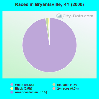
- 4,27897.5%White alone
- 671.5%Hispanic
- 210.5%Black alone
- 140.3%Two or more races
- 50.1%American Indian alone
- 40.09%Asian alone
Races in Bryantsville detailed stats: ancestries, foreign born residents, place of birth
 Recent articles from our blog. Our writers, many of them Ph.D. graduates or candidates, create easy-to-read articles on a wide variety of topics.
Current Local Time: EST time zone
Elevation: 953 feet
Land area: 57.0 square miles.
Population density: 88 people per square mile (very low).

| Bryantsville CCD: | 0.7% ($681) |
| Kentucky: | 0.8% ($610) |
Nearest city with pop. 50,000+: Fayette, KY  (22.5 miles , pop. 260,512).
Nearest city with pop. 1,000,000+: Chicago, IL (326.3 miles , pop. 2,896,016).
Nearest cities:
), ), ), )Latitude: 37.73 N, Longitude: 84.66 W
Area code: 859

| Here: | 3.6% |
| Kentucky: | 3.8% |

- Construction (11.9%)
- Health care (9.2%)
- Educational services (7.3%)
- Agriculture, forestry, fishing & hunting (5.5%)
- Professional, scientific, technical services (5.0%)
- Printing & related support activities (3.7%)
- Food & beverage stores (3.7%)

- Construction (20.6%)
- Agriculture, forestry, fishing & hunting (7.9%)
- Health care (5.4%)
- Educational services (3.9%)
- Miscellaneous manufacturing (3.5%)
- Public administration (3.4%)
- Printing & related support activities (3.3%)

- Health care (13.5%)
- Educational services (11.3%)
- Professional, scientific, technical services (7.5%)
- Food & beverage stores (6.8%)
- Accommodation & food services (4.5%)
- Department & other general merchandise stores (4.3%)
- Printing & related support activities (4.1%)

- Other production occupations, including supervisors (5.1%)
- Other sales and related occupations, including supervisors (4.7%)
- Farmers and farm managers (3.9%)
- Building and grounds cleaning and maintenance occupations (3.8%)
- Material recording, scheduling, dispatching, and distributing workers (3.1%)
- Electrical equipment mechanics and other installation, maintenance, and repair workers, including supervisors (3.1%)
- Retail sales workers, except cashiers (3.0%)

- Other production occupations, including supervisors (6.0%)
- Farmers and farm managers (5.4%)
- Electrical equipment mechanics and other installation, maintenance, and repair workers, including supervisors (5.3%)
- Other sales and related occupations, including supervisors (5.0%)
- Metal workers and plastic workers (4.3%)
- Agricultural workers, including supervisors (4.2%)
- Supervisors, construction and extraction workers (4.0%)

- Building and grounds cleaning and maintenance occupations (5.2%)
- Bookkeeping, accounting, and auditing clerks (5.2%)
- Secretaries and administrative assistants (4.8%)
- Assemblers and fabricators (4.8%)
- Other sales and related occupations, including supervisors (4.4%)
- Cashiers (4.1%)
- Material recording, scheduling, dispatching, and distributing workers (4.0%)
Average climate in Bryantsville, Kentucky
Based on data reported by over 4,000 weather stations


(lower is better)

Air Quality Index (AQI) level in 2023 was 77.5. This is about average.
| City: | 77.5 |
| U.S.: | 72.6 |

Carbon Monoxide (CO) [ppm] level in 2002 was 0.0391. This is significantly better than average. Closest monitor was 22.0 miles away from the city center.
| City: | 0.0391 |
| U.S.: | 0.2513 |

Nitrogen Dioxide (NO2) [ppb] level in 2022 was 6.38. This is worse than average. Closest monitor was 7.9 miles away from the city center.
| City: | 6.38 |
| U.S.: | 5.11 |

Sulfur Dioxide (SO2) [ppb] level in 2022 was 1.07. This is significantly better than average. Closest monitor was 7.9 miles away from the city center.
| City: | 1.07 |
| U.S.: | 1.51 |

Ozone [ppb] level in 2023 was 37.5. This is about average. Closest monitor was 7.1 miles away from the city center.
| City: | 37.5 |
| U.S.: | 33.3 |

Particulate Matter (PM2.5) [µg/m3] level in 2022 was 7.97. This is about average. Closest monitor was 20.5 miles away from the city center.
| City: | 7.97 |
| U.S.: | 8.11 |
Tornado activity:
Bryantsville-area historical tornado activity is near Kentucky state average. It is 28% greater than the overall U.S. average.
On 4/3/1974, a category F4 (max. wind speeds 207-260 mph) tornado 8.8 miles away from the Bryantsville place center killed 7 people and injured 28 people.
On 4/3/1974, a category F3 (max. wind speeds 158-206 mph) tornado 3.9 miles away from the place center killed one person and injured 98 people and caused between $500,000 and $5,000,000 in damages.
Earthquake activity:
Bryantsville-area historical earthquake activity is significantly above Kentucky state average. It is 83% greater than the overall U.S. average.On 7/27/1980 at 18:52:21, a magnitude 5.2 (5.1 MB, 4.7 MS, 5.0 UK, 5.2 UK, Class: Moderate, Intensity: VI - VII) earthquake occurred 51.0 miles away from Bryantsville center
On 4/18/2008 at 09:36:59, a magnitude 5.4 (5.1 MB, 4.8 MS, 5.4 MW, 5.2 MW) earthquake occurred 182.5 miles away from the city center
On 9/7/1988 at 02:28:09, a magnitude 4.6 (4.5 MB, 4.6 LG, Class: Light, Intensity: IV - V) earthquake occurred 51.3 miles away from the city center
On 4/18/2008 at 09:36:59, a magnitude 5.2 (5.2 MW, Depth: 8.9 mi) earthquake occurred 182.5 miles away from the city center
On 6/10/1987 at 23:48:54, a magnitude 5.1 (4.9 MB, 4.4 MS, 4.6 MS, 5.1 LG) earthquake occurred 190.6 miles away from the city center
On 6/18/2002 at 17:37:15, a magnitude 5.0 (4.3 MB, 4.6 MW, 5.0 LG) earthquake occurred 171.3 miles away from the city center
Magnitude types: regional Lg-wave magnitude (LG), body-wave magnitude (MB), surface-wave magnitude (MS), moment magnitude (MW)
Natural disasters:
The number of natural disasters in Garrard County (11) is smaller than the US average (15).Major Disasters (Presidential) Declared: 7
Emergencies Declared: 3
Causes of natural disasters: Floods: 4, Storms: 4, Winter Storms: 4, Tornadoes: 3, Mudslides: 2, Blizzard: 1, Freeze: 1, Hurricane: 1, Snow: 1, Snowfall: 1, Other: 1 (Note: some incidents may be assigned to more than one category).
Hospitals and medical centers near Bryantsville:
- CHARLESTON HEALTH CARE CENTER (Nursing Home, about 9 miles away; DANVILLE, KY)
- GARRARD CO MEMORIAL HOSP (Hospital, about 9 miles away; LANCASTER, KY)
- CHRISTIAN CARE CENTER OF LANCASTER (Nursing Home, about 9 miles away; LANCASTER, KY)
- DCI - DANVILLE (Dialysis Facility, about 10 miles away; DANVILLE, KY)
- FMC - DANVILLE (Dialysis Facility, about 10 miles away; DANVILLE, KY)
- HARRODSBURG HEALTH CARE MANOR (Nursing Home, about 10 miles away; HARRODSBURG, KY)
- KINDRED NURSING AND REHABILITATION-HARRODSBURG (Nursing Home, about 10 miles away; HARRODSBURG, KY)
Colleges/universities with over 2000 students nearest to Bryantsville:
- Eastern Kentucky University (about 20 miles; Richmond, KY; Full-time enrollment: 13,525)
- Bluegrass Community and Technical College (about 23 miles; Lexington, KY; FT enrollment: 8,560)
- University of Kentucky (about 23 miles; Lexington, KY; FT enrollment: 23,517)
- Kentucky State University (about 35 miles; Frankfort, KY; FT enrollment: 2,112)
- Campbellsville University (about 47 miles; Campbellsville, KY; FT enrollment: 2,948)
- Somerset Community College (about 47 miles; Somerset, KY; FT enrollment: 4,698)
- Lindsey Wilson College (about 56 miles; Columbia, KY; FT enrollment: 2,552)
Points of interest:
Notable locations in Bryantsville: Camp Dick Robinson (A), Castlewood Camp (B), Hoskins Crossroads (C), Gaskins Camp (D), Castlewood Camp (E), Camp Dick Fire Department Station 3 (F), Camp Dick Fire Department Station 2 (G), Camp Dick Fire Department Station 1 (H). Display/hide their locations on the map
Churches in Bryantsville include: Forks Dix River Church (A), Harmony Church (B), Lanes Chapel (C), Mount Hebron Church (D), Mount Olivet Church (E), Pleasant Grove Church (F). Display/hide their locations on the map
Streams, rivers, and creeks: Davis Creek (A), Tanyard Branch (B), Canoe Creek (C), Sugar Creek (D), McKecknie Creek (E), Rocky Fork (F), White Oak Creek (G). Display/hide their locations on the map
| This place: | 2.6 people |
| Kentucky: | 2.5 people |
| This place: | 77.5% |
| Whole state: | 66.9% |
| This place: | 7.1% |
| Whole state: | 6.4% |
Likely homosexual households (counted as self-reported same-sex unmarried-partner households)
- Lesbian couples: 0.6% of all households
- Gay men: 0.2% of all households
| This place: | 10.9% |
| Whole state: | 15.8% |
| This place: | 4.8% |
| Whole state: | 6.6% |
For population 15 years and over in Bryantsville:

- Never married: 16.0%
- Now married: 74.8%
- Separated: 1.2%
- Widowed: 2.6%
- Divorced: 6.7%
For population 25 years and over in Bryantsville:
- High school or higher: 75.7%
- Bachelor's degree or higher: 9.2%
- Graduate or professional degree: 2.6%
- Unemployed: 5.0%
- Mean travel time to work (commute): 34.9 minutes


| Here: | 10.6 |
| Kentucky average: | 13.8 |
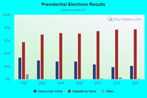
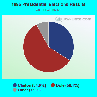

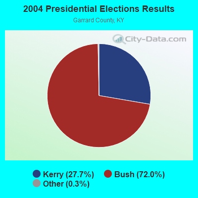


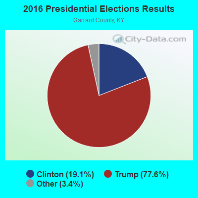
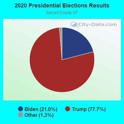
Graphs represent county-level data. Detailed 2008 Election Results
Religion statistics for Bryantsville, KY (based on Garrard County data)
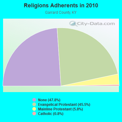
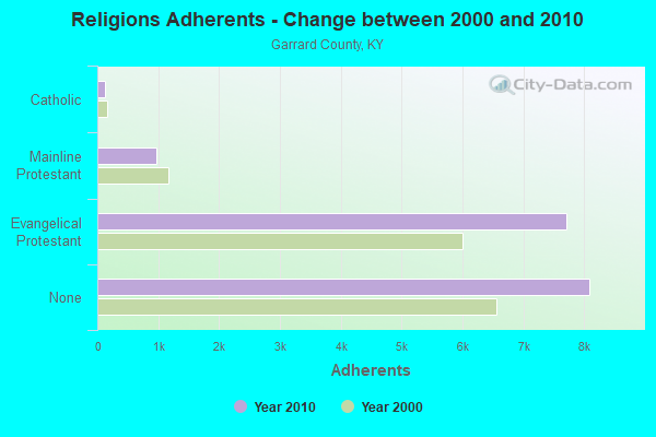
| Religion | Adherents | Congregations |
|---|---|---|
| Evangelical Protestant | 7,702 | 22 |
| Mainline Protestant | 973 | 11 |
| Catholic | 131 | 1 |
| Other | 15 | - |
| None | 8,091 | - |
Food Environment Statistics:
| Garrard County: | 2.35 / 10,000 pop. |
| Kentucky: | 2.19 / 10,000 pop. |
| Garrard County: | 0.59 / 10,000 pop. |
| Kentucky: | 0.74 / 10,000 pop. |
| Garrard County: | 2.94 / 10,000 pop. |
| State: | 4.36 / 10,000 pop. |
| Garrard County: | 1.77 / 10,000 pop. |
| Kentucky: | 5.74 / 10,000 pop. |
| Garrard County: | 11.7% |
| Kentucky: | 11.0% |
| Here: | 30.7% |
| Kentucky: | 30.0% |
| Garrard County: | 17.6% |
| Kentucky: | 15.9% |
Strongest AM radio stations in Bryantsville:
- WHAS (840 AM; 50 kW; LOUISVILLE, KY; Owner: CLEAR CHANNEL BROADCASTING LICENSES, INC.)
- WHIR (1230 AM; 1 kW; DANVILLE, KY; Owner: HOMETOWN B/CSTNG OF DANVILLE, INC.)
- WVLK (590 AM; 5 kW; LEXINGTON, KY; Owner: CUMULUS LICENSING CORP.)
- WKYY (1280 AM; 1 kW; LANCASTER, KY; Owner: LANCASTER BROADCASTERS, INC.)
- WHBN (1420 AM; 1 kW; HARRODSBURG, KY; Owner: MORTENSON BROADCASTING COMPANY OF KE)
- WLAP (630 AM; 5 kW; LEXINGTON, KY; Owner: CITICASTERS LICENSES, L.P.)
- WCGW (770 AM; daytime; 1 kW; NICHOLASVILLE, KY; Owner: MORTENSON BROADCASTING COMPANY)
- WXRA (1580 AM; 10 kW; GEORGETOWN, KY; Owner: CITICASTERS LICENSES, L.P.)
- WLW (700 AM; 50 kW; CINCINNATI, OH; Owner: JACOR BROADCASTING CORPORATION)
- WDFB (1170 AM; daytime; 1 kW; JUNCTION CITY, KY; Owner: ALUM SPRINGS VISION & OUTREACH CORP)
- WRSL (1520 AM; daytime; 1 kW; STANFORD, KY; Owner: LINCOLN-GARRARD BROADCASTING CO.,INC)
- WSAI (1530 AM; 50 kW; CINCINNATI, OH; Owner: JACOR BROADCASTING CORPORATION)
- WKVL (850 AM; daytime; 50 kW; KNOXVILLE, TN; Owner: HORNE RADIO, LLC)
Strongest FM radio stations in Bryantsville:
- WHIR-FM (107.1 FM; DANVILLE, KY; Owner: CLEAR CHANNEL BROADCASTING LICENSES, INC.)
- WJMM-FM (99.3 FM; HARRODSBURG, KY; Owner: MORTENSON BROADCASTING COMPANY OF CENTRAL KENTUCKY, LLC)
- WUKY (91.3 FM; LEXINGTON, KY; Owner: BD. OF TRUSTEES UNIV. OF KENTUCKY)
- WXKY-FM (96.3 FM; STANFORD, KY; Owner: LINCOLN-GARRARD BROADCASTING CO.,INC)
- WRNZ (105.1 FM; LANCASTER, KY; Owner: HOMETOWN BROADCASTING OF LANCASTER, INC.)
- WEKU (88.9 FM; RICHMOND, KY; Owner: EASTERN KENTUCKY UNIVERSITY)
- WVLK-FM (92.9 FM; LEXINGTON, KY; Owner: CUMULUS LICENSING CORP.)
- WDFB-FM (88.1 FM; DANVILLE, KY; Owner: ALUM SPRINGS EDUCATIONAL CORPORATION)
- WLRO (101.5 FM; RICHMOND, KY; Owner: CUMULUS LICENSING CORP.)
- WLTO (102.5 FM; NICHOLASVILLE, KY; Owner: CUMULUS LICENSING CORP.)
- WVRB (95.3 FM; WILMORE, KY; Owner: VERNON R. BALDWIN, INC.)
- WXZZ (103.3 FM; GEORGETOWN, KY; Owner: CUMULUS LICENSING CORP.)
- WCYO (100.7 FM; IRVINE, KY; Owner: KENTUCKY RIVER BROADCASTING CO.)
- WBUL-FM (98.1 FM; LEXINGTON, KY; Owner: CITICASTERS LICENSES, L.P.)
- WMXL (94.5 FM; LEXINGTON, KY; Owner: CITICASTERS LICENSES, INC.)
- WKQQ (100.1 FM; WINCHESTER, KY; Owner: CITICASTERS LICENSES, L.P.)
- WLFX (106.7 FM; BEREA, KY; Owner: WALLINGFORD COMMUNICATIONS, LLC)
- WCDA (106.3 FM; VERSAILLES, KY; Owner: L.M. COMMUNICATIONS, INC)
- WLKT (104.5 FM; LEXINGTON-FAYETTE, KY; Owner: CITICASTERS LICENSES, L.P.)
- WKYL (102.1 FM; LAWRENCEBURG, KY; Owner: DAVENPORT BROADCASTING, INC.)
TV broadcast stations around Bryantsville:
- WDKY-TV (Channel 56; DANVILLE, KY; Owner: WDKY LICENSEE, LLC)
- WKLE (Channel 46; LEXINGTON, KY; Owner: KENTUCKY AUTHORITY FOR EDUCATIONAL TV)
- WKYT-TV (Channel 27; LEXINGTON, KY; Owner: WKYT LICENSEE CORP.)
- WTVQ-TV (Channel 36; LEXINGTON, KY; Owner: MEDIA GENERAL COMMUNICATIONS, INC.)
- WLEX-TV (Channel 18; LEXINGTON, KY; Owner: WLEX COMMUNICATIONS, L.L.C.)
- WKSO-TV (Channel 29; SOMERSET, KY; Owner: KENTUCKY AUTHORITY FOR EDUCATIONAL TV)
- WBKI-TV (Channel 34; CAMPBELLSVILLE, KY; Owner: LOUISVILLE COMMUNICATIONS, LLC)
- WBLU-LP (Channel 62; LEXINGTON, KY; Owner: SANDRA B. POWLEY)

Bryantsville fatal accident list:
FCC Registered Antenna Towers:
1- 3.4 Km E Of Buena Vista School Nr (Lat: 37.765278 Lon: -84.635000), Type: 77.1, Overall height: 76.2 m, Registrant: 104.3@wnlt.Com, , Fairf-ield, Phone: (513) 829-7700
FCC Registered Microwave Towers:
2- STATION, 2 Mi Ene Of St Route 52 And St Route 590 (Lat: 37.643944 Lon: -84.650472), Overall height: 152.4 m, Call Sign: WNEH363,
Assigned Frequencies: 1985.00 MHz, Grant Date: 01/12/1998, Expiration Date: 08/09/2000, Cancellation Date: 06/22/2000, Phone: (713) 757-2212
- 2 Mi Ene Of Sr 52 And Sr 590 (Lat: 37.643944 Lon: -84.650472), Structure height: 152.4 m, Call Sign: WPNI972,
Assigned Frequencies: 1945.00 MHz, Grant Date: 01/09/1998, Expiration Date: 01/09/2003, Cancellation Date: 11/19/2001, Phone: (202) 223-9222
FAA Registered Aircraft:
1- Aircraft: CESSNA 182P (Category: Land, Seats: 4, Weight: Up to 12,499 Pounds, Speed: 120 mph), Engine: CONT MOTOR O-470 SERIES (230 HP) (Reciprocating)
N-Number: 52959, N52959, N-52959, Serial Number: 18262975, Year manufactured: 1974, Airworthiness Date: 05/09/1991, Certificate Issue Date: 11/21/2016
Registrant (Corporation): Triple T Metal Corp, Po Box 52, Bryantsville, KY 40444

- 67.8%Electricity
- 15.8%Bottled, tank, or LP gas
- 11.3%Wood
- 2.9%Fuel oil, kerosene, etc.
- 2.3%Utility gas

- 40.3%Electricity
- 35.9%Bottled, tank, or LP gas
- 13.9%Wood
- 5.6%Fuel oil, kerosene, etc.
- 4.3%Utility gas
Bryantsville compared to Kentucky state average:
- Unemployed percentage significantly below state average.
- Black race population percentage significantly below state average.
- Hispanic race population percentage below state average.
- Median age below state average.
- Foreign-born population percentage significantly below state average.
- Renting percentage below state average.
- Length of stay since moving in significantly above state average.
- Number of rooms per house significantly below state average.
- House age significantly below state average.
- Percentage of population with a bachelor's degree or higher below state average.
Bryantsville on our top lists:
- #6 on the list of "Top 101 cities with largest percentage of females in occupations: printing workers (population 5,000+)"
- #6 on the list of "Top 101 cities with largest percentage of females in industries: printing and related support activities (population 5,000+)"
- #13 on the list of "Top 101 cities with largest percentage of males in occupations: painters and paperhangers (population 5,000+)"
- #20 on the list of "Top 101 cities with largest percentage of males in occupations: special education teachers (population 5,000+)"
- #21 on the list of "Top 101 cities with largest percentage of females in occupations: carpenters (population 5,000+)"
- #22 on the list of "Top 101 cities with largest percentage of males in industries: printing and related support activities (population 5,000+)"
- #24 on the list of "Top 101 cities with largest percentage of females in occupations: farmers and farm managers (population 5,000+)"
- #24 on the list of "Top 101 cities with largest percentage of females in industries: farm supplies merchant wholesalers (population 5,000+)"
- #28 on the list of "Top 101 cities with largest percentage of females in occupations: assemblers and fabricators (population 5,000+)"
- #29 on the list of "Top 101 cities with largest percentage of males in industries: furniture and home furnishing merchant wholesalers (population 5,000+)"
- #31 on the list of "Top 101 cities with largest percentage of females in industries: food and beverage stores (population 5,000+)"
- #31 on the list of "Top 101 cities with largest percentage of females in industries: private households (population 5,000+)"
- #35 on the list of "Top 101 cities with largest percentage of males in industries: office supplies and stationery stores (population 5,000+)"
- #36 on the list of "Top 101 cities with largest percentage of males in industries: rail transportation (population 5,000+)"
- #44 on the list of "Top 101 cities with largest percentage of females in industries: plastics and rubber products (population 5,000+)"
- #50 on the list of "Top 101 cities with largest percentage of males in industries: leather and allied products (population 5,000+)"
- #51 on the list of "Top 101 cities with largest percentage of females in industries: leather and allied products (population 5,000+)"
- #56 on the list of "Top 101 cities with largest percentage of males in industries: groceries and related products merchant wholesalers (population 5,000+)"
- #65 on the list of "Top 101 cities with largest percentage of females in industries: machinery (population 5,000+)"
- #68 on the list of "Top 101 cities with largest percentage of males in industries: miscellaneous manufacturing (population 5,000+)"

|
Total of 1 patent application in 2008-2024.